Season’s first cyclone, ‘Shakhti’, forms over Arabian Sea; IMD warns of high sea activity
TNN | Oct 4, 2025
The season’s first Arabian Sea cyclonic storm, ‘Shakhti’, intensified on Friday, currently positioned west-southwest of Dwarka. Expected to become a severe cyclonic storm, it is unlikely to significantly impact Indian landmass, though remnants may bring rain to Gujarat. Sea conditions will be very rough, prompting warnings for fishermen. Meanwhile, Maharashtra anticipates light to moderate rain due to another system.
The system, currently centred about 250km west-southwest of Dwarka, is expected to strengthen into a severe cyclonic storm by Saturday. While forecasters said, it is unlikely to make a significant impact on Indian landmass, sea conditions are expected to be rough over the weekend.
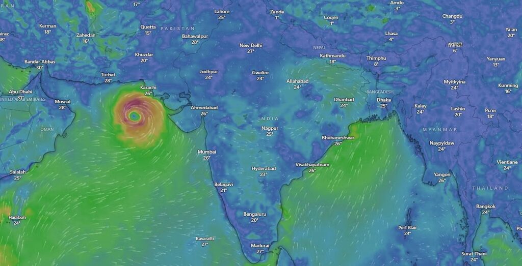
As of 11.30am on Friday, Cyclone Shakhti lay over the northeast Arabian Sea near latitude 21.7°N and longitude 66.8°E, around 270km southwest of Naliya, 300km west of Porbandar and 360km south of Karachi in Pakistan.
The system was moving northwestwards at a speed of 8kmph and will later track west-southwestwards towards the central Arabian Sea, said IMD. It is likely to reach central parts of north and adjoining central Arabian Sea by Oct 5.
Though the system will intensify into a severe cyclone, it will weaken considerably before nearing Gujarat’s coastline. Rainfall is expected in parts of Gujarat, but no major impact is anticipated in India,” said a weather blogger from Vagaries of Weather.
Independent weather forecaster Abhijit Modak also said, “The storm’s remnants may bring some rain to Saurashtra and Kutch.”
An IMD official confirmed that the storm’s trajectory is away from the Indian landmass. “The movement is west-northwestwards initially and then west-southwestwards. The system won’t directly impact land but will affect sea conditions. Fishermen are advised not to venture into the sea,” the official said.
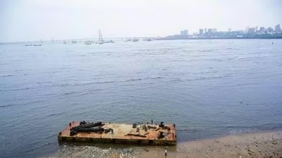
According to IMD, sea conditions were very rough to high over the northwest Arabian Sea, adjoining northeast and central Arabian Sea till the afternoon of Oct 3 and will turn high to very high between Oct 4-6. Rough to very rough sea conditions are expected along and off the Gujarat-north Maharashtra and Pakistan coasts till Oct 5.
From Oct 3-6, fishermen have been advised to not venture into northwest Arabian Sea, adjoining northeast Arabian Sea, central Arabian Sea, and along/off Gujarat-north Maharashtra coasts.
More rain in Maharashtra
Meanwhile, light to moderate rain and thunderstorms are likely at most places in Madhya Maharashtra and Marathwada on Oct 3-4, influenced by a depression over interior Odisha, added IMD.
On October 4, 2025, the India Meteorological Department (IMD) confirmed that Cyclone Shakti, the season’s first cyclonic storm in the Arabian Sea, had intensified into a severe cyclone. The storm is moving away from the Indian mainland, but coastal areas of Gujarat and Maharashtra are experiencing rough seas and heavy rainfall.

Shakti becomes season’s first severe cyclone, IMD issues advisory for Gujarat, Maharashtra
Officials said on Saturday that the storm is currently moving west-southwestward and is churning the sea as it continues to strengthen Cyclone Shakti, the first cyclonic storm of the post-monsoon season in the Arabian Sea, has intensified into a severe system with sustained wind speeds of 100 kmph and stronger gusts, according to the India Meteorological Department (IMD). Officials said on Saturday that the storm is currently moving west-southwestward and is churning the sea as it continues to strengthen.
The IMD said Shakti was centred about 420 km from Dwarka in Gujarat as of Saturday afternoon. The storm is expected to move further into the Arabian Sea and reach the northwest and adjoining west-central regions by Sunday. From Monday morning, the cyclone is likely to recurve east-northeastwards and gradually weaken.
“Cyclone Shakti has intensified into a severe cyclonic storm over the east-central and adjoining northeast Arabian Sea. It is likely to move west-southwestwards and reach the northwest and adjoining west-central Arabian Sea by Sunday, and then recurve east-northeastwards from Monday morning, weakening gradually,” the IMD said in its latest bulletin.
Warnings and Impact
Under the influence of Shakti, sea conditions along and off the Gujarat and north Maharashtra coasts, as well as near the Pakistan coastline, are expected to remain rough to very rough until Sunday. The IMD has advised fishermen not to venture into the northwest, northeast, or central Arabian Sea, and along and off the Gujarat–north Maharashtra coast, until at least Tuesday, citing safety concerns.
Officials have also urged coastal authorities to remain on alert for potential high waves, sea surges, and strong winds. While no direct landfall threat has been issued, the rough weather may disrupt marine activity and small fishing operations in coastal districts.
Cyclone Pattern and Regional Context
In recent years, the Arabian Sea has seen a rise in both the frequency and intensity of cyclones — a pattern linked by meteorologists to warming sea surface temperatures. Historically, the Bay of Bengal has produced a larger share of tropical storms, but recent years have seen notable systems form in the west.
Significant recent examples include Cyclone Tauktae in May 2021, which caused severe damage along the western coast, and Cyclone Biparjoy in June 2023, which originated in the Arabian Sea before striking Gujarat with destructive force.
Name and Origin
The cyclone has been named Shakti, a name contributed by Sri Lanka under the naming convention maintained by the World Meteorological Organisation (WMO) and the United Nations Economic and Social Commission for Asia and the Pacific (ESCAP) Panel on Tropical Cyclones. The panel comprises 13 member countries bordering the Bay of Bengal and the Arabian Sea, each responsible for suggesting names from pre-approved lists.
The IMD, which serves as the Regional Specialised Meteorological Centre (RSMC) for tropical cyclones in the North Indian Ocean, officially assigns names to storms based on this regional system.
Current status and forecast
- Intensification: Cyclone Shakti intensified into a severe cyclonic storm with sustained wind speeds of 100 kmph and gusts up to 110 kmph.
- Location: As of October 4, the storm was located about 420 km west of Dwarka, Gujarat.
- Trajectory: The cyclone is moving west-southwestward, away from the Indian coast, and is expected to reach the northwest and west-central Arabian Sea by October 5.
- Weakening: It is forecast to recurve east-northeastward and weaken gradually starting from October 6.
- No Landfall: Forecasters do not anticipate the storm to make landfall on the Indian coast.

The India Meteorological Department (IMD) on Saturday reported that Cyclone Shakhti over the northeast Arabian Sea has intensified into a severe cyclonic storm and is moving westwards at a speed of 13 kmph.
According to IMD, the storm is currently located about 420 km west of Dwarka, 420 km west-southwest of Naliya, 390 km south-southwest of Karachi (Pakistan), and 480 km west of Porbandar.
The system is expected to move west-southwestwards and reach the northwest and adjoining west-central Arabian Sea by October 5. Thereafter, it is likely to recurve and move east-northeastwards from the morning of October 6, gradually weakening thereafter.
Wind Warnings
- Current winds: Gale-force winds reaching 90–100 kmph, gusting up to 110 kmph, are prevailing over the northwest and adjoining northeast Arabian Sea.
- Forecast:
- By October 4–5: Winds may strengthen to 100–110 kmph, gusting to 125 kmph.
- By October 6: Wind speeds will reduce to 80–90 kmph, gusting to 100 kmph.
- By October 7: Further weakening to 65–75 kmph, gusting to 85 kmph.
- Coastal impact: Squally winds of 45–55 kmph, gusting up to 65 kmph, are expected along and off the Gujarat–north Maharashtra coasts between October 4–7.
Sea Conditions
- Very high sea conditions are likely over the northwest and adjoining northeast Arabian Sea between October 4–7.
- The central Arabian Sea is expected to experience rough to very rough conditions until October 5, turning high to very high from midnight of October 5 until October 7.
- Rough to very rough seas are also expected along the Gujarat, north Maharashtra, and Pakistan coasts until October 7.
Advisory: Fishermen are advised not to venture into the Arabian Sea during this period due to the dangerous sea and wind conditions. Coastal authorities in Gujarat, Maharashtra, and southern Pakistan have been placed on high alert.
Impact on coastal areas
Despite moving away from the mainland, the storm is affecting coastal regions with high sea activity and adverse weather.
Season’s First Cyclone ‘Shakti’ Forms Over Arabian Sea, IMD Warns Of Heavy Rain In Mumbai
IMD says Mumbai, Thane, Raigad, Ratnagiri, and other districts could see heavy rain and rough seas as Cyclone Shakti intensifies.
Cyclone Shakti, the first cyclonic storm of the season over the Arabian Sea, has intensified and is expected to bring rough weather conditions along the Maharashtra coast, including Mumbai, in the coming days, according to the India Meteorological Department (IMD).
The IMD on Friday placed Mumbai, Thane, Palghar, Raigad, Ratnagiri and Sindhudurg on alert, warning of high winds and heavy rain between October 3 and 7. Wind speeds of 45-55 kmph, gusting up to 65 kmph, are likely along the north Maharashtra coast between October 3 and 5. Fishermen have been strongly advised against venturing into the sea as very rough to high sea conditions are expected.
RECOMMENDED STORIES
Cyclone Shakhti churns up Arabian Sea off Gujarat coast
IMD predicts heavy showers in Mumbai, suburbs; orange alert issued
Heavy downpour soaks Mumbai overnight; over 100 mm rain in some areas
Heavy rains soak Mumbai overnight; IMD forecasts more showers
Heavy rain warning for Maharashtra
While the cyclone’s centre remains away from India’s coastline, its outer bands are expected to bring heavy to very heavy rainfall in parts of Maharashtra. Interior districts, particularly East Vidarbha and Marathwada, are likely to receive intense showers on October 3-4, which could trigger flooding in low-lying areas of North Konkan. Thunderstorms and moderate rainfall are also forecast in Madhya Maharashtra and Marathwada due to a depression over interior Odisha adding to the weather system.
The Maharashtra government has asked district administrations to activate disaster management systems, prepare evacuation plans for vulnerable areas, issue public advisories, and ensure safety during heavy rains. Mumbai, Thane, Raigad, Pune, and Ratnagiri districts have been placed on a “yellow alert.”
Where Cyclone Shakti stands now
As of Friday morning, the IMD reported that Cyclone Shakti was centred about 270 km southwest of Naliya in Gujarat, 300 km west of Porbandar and 360 km south of Karachi in Pakistan. The storm was moving northwestwards at a speed of around 8 kmph.
An IMD official confirmed that the storm’s trajectory is away from the Indian landmass: “The movement is west-northwestwards initially and then west-southwestwards. The system won’t directly impact land but will affect sea conditions. Fishermen are advised not to venture into the sea.”
Warnings for sea conditions
According to the IMD, sea conditions will remain very rough to high over the northwest Arabian Sea, adjoining northeast and central Arabian Sea until October 3, and will turn high to very high between October 4 and 6. Rough to very rough seas are expected along and off the Gujarat-north Maharashtra and Pakistan coasts till October 5.
Recent heavy rains add to concern
The cyclone warning comes just days after Maharashtra was hit by intense rainfall, with Mumbai, Thane and Raigad placed on red alert last week. The IMD has already predicted above-normal rainfall for the state in October.
During a virtual press briefing earlier this week, Mrutyunjay Mohapatra, Director-General of Meteorology, said that October is likely to see heightened rainfall activity, according to a report by Hindustan Times. With Cyclone Shakti now brewing in the Arabian Sea, authorities are preparing for more spells of heavy rain, particularly in coastal and interior districts.
- Maharashtra: The IMD has issued an alert for Mumbai, Thane, Palghar, and other districts, warning of heavy rain and gusty winds. Authorities have activated disaster management systems and are prepared for evacuations in vulnerable areas.
- Gujarat: Rough sea conditions are expected along the Gujarat coast.
- Fishermen warning: Fishermen have been advised not to venture into the Arabian Sea due to very rough to high sea conditions.
Climate change context
The formation of severe cyclones in the Arabian Sea is becoming more frequent and intense, a trend that scientists link to climate change and warming ocean temperatures.
Cyclone ‘Shakhti’ forms over Arabian Sea, to move away from Indian mainland
Storm comes two years after ‘Biparjoy’ and four years after ‘Tauktae’, a sign of the warming Arabian Sea
The India Meteorological Department (IMD) on October 3, 2025, confirmed the formation of Cyclone Shakhti, named by Sri Lanka, over the northeast Arabian Sea.
“At 1800 UTC of 3 Oct, CS Shakhti lay centered about 340 km west of Dwarka. It is likely to move west-southwestwards and intensify further into a severe cyclonic storm around 0000 UTC of 4 Oct. Thereafter, to reach central parts of north & adj central Arabian Sea by 5th October. Thereafter, it will recurve and move east-northeastward from 0000 UTC of 6th October 2025,” the IMD said in a post on the intervening night of October 3 and 4.
In an earlier post, the IMD had noted that Shakhti “lay centered at 1730 hrs IST of today, the 3rd October, 2025 over the same region near latitude 22.0N and longitude 66.4E, about 280 km west of Dwarka, 290 km west-southwest of Naliya, 330 km south-southwest of Karachi (Pakistan) and 320 km west of Porbandar. It is likely to move west-northwestwards initially and then west-southwestwards and intensify further into a severe cyclonic storm around morning of 4th October, 2025. Thereafter, it is likely to continue to move west-southwestwards and reach central parts of north and adjoining central Arabian Sea by 5th October.”
Fishermen have been advised not to venture into the northwest Arabian Sea, adjoining areas of northeast Arabian Sea, central Arabian sea and along and off the Gujarat-north Maharashtra coasts during October 3-6, 2025.
The cyclone is yet another sign of the warming Arabian Sea, which was once less cyclonically active than the Bay of Bengal. Rapid intensification due to warmer sea temperatures has led to cyclones such as Tauktae (2021) and Biparjoy (2023) off India’s west coast in the last five years.
- The Arabian Sea has experienced a 52% increase in cyclone frequency and an 80% increase in cyclone duration during the 2001–2019 period compared to previous decades.
- More cyclones are forming in the Arabian Sea, while activity in the Bay of Bengal is decreasing.
- Notable past examples include Cyclone Tauktae (2021) and Cyclone Biparjoy (2023), which both originated in the Arabian Sea.
After longest lull since 2012, year’s first cyclone forms over Arabian Sea
The India Meteorological Department (IMD) said in a 4pm bulletin on Friday that a deep depression in the northeast Arabian Sea had intensified into a cyclone at 11.30am, ending an unusually calm period for India’s coasts. This is the first cyclone to form in the North Indian Ocean this year — a dry spell not seen since 2012, when no cyclones were reported in either the Bay of Bengal or the Arabian Sea up to September.
(HT_PRINT)")
To be sure, this cyclone is more likely to make the seas rough than cause havoc inland. IMD’s bulletin shows that it is likely to move further away from India as it intensifies into a severe cyclonic storm.
What is somewhat interesting is that the first cyclone of the season has formed in the Arabian Sea, which reports a lower frequency of cyclones than the Bay of Bengal.