Cyclone Shakhti moving away from Maharashtra coast, to weaken after October 6
Coastal districts of Maharashtra, including Mumbai, Thane, Palghar, Raigad, Ratnagiri, and Sindhudurg, have been on high to moderate alert due to strong winds, heavy rains, and rough seas, with fishermen warned not to venture out.
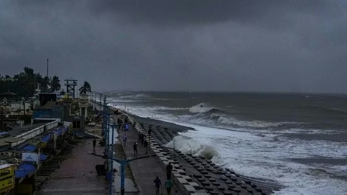
The storm is expected to recurve eastwards from October 6 and weaken gradually. (Photo: Reuters)
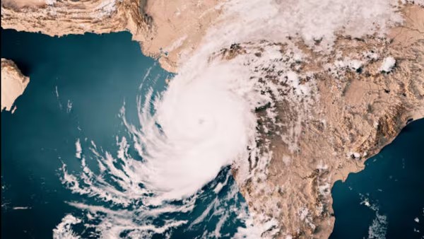
Severe Cyclonic Storm (SCS) Shakhti over the northwest Arabian Sea is steadily moving west-southwest and is expected to reach the northwest Arabian Sea by Sunday evening (October 5), the India Meteorological Department (IMD) said in its latest update late Saturday night.
The storm, located about 320 km east-southeast of Ras Al Hadd in Oman, is forecast to recurve eastwards from October 6 and gradually weaken as it moves further over the Arabian Sea.
t is likely to move west-southwestwards and reach northwest and adjoining westcentral Arabian Sea by evening of today, the 5th October. Thereafter, it will recurve and move nearly eastwards from morning of 6th October 2025 and weaken gradually.
The IMD had earlier warned of heavy rain, strong winds, and rough sea conditions along Maharashtra’s coastline as the cyclone intensified. Disaster management authorities have been asked to stay vigilant, and evacuation plans have been put in place in low-lying coastal areas.
Mumbai, Thane, Palghar, Raigad, Ratnagiri, and Sindhudurg districts remain under high to moderate alert until October 7. Wind speeds of 45–55 kmph, gusting up to 65 kmph, have already been recorded along the northern Maharashtra coast, and conditions are expected to worsen as the system moves westwards.
Authorities have cautioned fishermen not to venture into the sea, while residents in vulnerable coastal areas are being advised to remain alert for tidal surges and localised flooding. Sea conditions along and off the Gujarat–north Maharashtra and Pakistan coasts are expected to remain rough to very rough through Sunday.
Cyclone Shakhti is moving away from the Maharashtra coast and is expected to weaken gradually from October 6, 2025. Subject: Current Weather Status and Extended range Forecast for the next two weeks
(02nd to 15th October 2025)
Salient Observed Features for the week ending 01st October 2025:
❖ Further Withdrawal of the Southwest Monsoon: The southwest monsoon further
withdrawn from some more parts of Gujarat, entire Rajasthan, some more parts of Madhya Pradesh & Uttar Pradesh and entire Western Himalayan Region (Jammu-Kashmir-Ladakh-Gilgit-Baltistan-Muzaffarabad, Himachal Pradesh, Uttarakhand) on 26th september, 2025. The line of withdrawal of southwest monsoon passed through 20°N/69°E, Veraval, Bharuch,
Ujjain, Jhansi, Shahjahanpur and 30°N/81°E on 26th September.
❖ Seasonal Monsoon Rainfall: Rainfall over the country as a whole during the 2025 southwest monsoon season (June- September) was 108% of its long period average (LPA). Seasonal rainfall over Northwest India, Central India, South Peninsula, and Northeast India were 127%, 115%, 110% and 80% of the respective LPA. Monthly rainfall over the country as a whole was 109% of LPA in June, 105% in both July and August, and 115% of LPA in September.
❖ Formation of a Depression over northwest & adjoining westcentral Bay of Bengal off
South Odisha – North Andhra Pradesh coasts and its movement across south Odisha,
south Chhattisgarh and east Vidarbha during 26th – 28th September: Under the influence of an upper air cyclonic circulation over eastcentral& adjoining northeast Bay of Bengal, a Low Pressure Area formed over central parts of north and adjoining central Bay of Bengal at 1730 hours IST of 25th September. It moved westwards and lay as a Well-Marked Low Pressure Area over northwest & adjoining central Bay of Bengal at 0530 hrs IST of 26th September. It moved west-northwestwards, concentrated into a Depression and lay cantered at 1730 hrs IST of 26th September over northwest & adjoining westcentral Bay of Bengal off South Odisha – North Andhra Pradesh coasts near latitude 19.3°N and longitude 86.1°E. Moving nearly
westwards, it crossed south Odisha coast near latitude 19.3°N and longitude 85.0°E close to Gopalpur around 0430 hrs IST of 27th September and lay centred at 0530 hrs IST of 27th September, over south coastal Odisha, near latitude 19.3°N and longitude 84.8°E. It weakened into a Well-Marked Low Pressure Area over West Vidarbha & adjoining north Madhya.
Maharashtra at 0830 hours IST of 28th September; lay over Gulf of Cambay &neighbourhood at 0530 hours IST of 29th September; lay over Gulf of Kutch &neighbourhood at 0830 hours IST of 30th September; lay over northeast Arabian Sea & adjoining Saurashtra coast at 0830 hours IST of 01 st October. Moving nearly westwards, it concentrated into a Depression and lay centered at 1730 hours IST of 01st October over northeast Arabian Sea near latitude 22.0ºN and longitude 68.3ºE. It caused extremely heavy rainfall at isolated places over Konkan & Goa, Gujarat Region, Saurashtra & Kutch on 29th September. Very heavy rainfall was
recorded at isolated places over Odisha on 27th& 29th September, Jharkhand, Telangana,
Rayalaseema on 27th September, Marathwada on 27th& 28th September, Madhya Maharashtra on 28th& 29th September, Konkan & Goa, Gujarat Region on 28th September, East Rajasthan on 1st October.
❖ Formation of a Deep Depression over west central & adjoining northwest Bay of Bengal on 01 st October: Under the influence of an upper air cyclonic circulation over east central Bay of Bengal & neighbourhood, a Low Pressure Area formed over west central Bay of Bengal at 1730 hrs IST of 30th September. It lay as a Well-Marked Low Pressure Area over the same region at 0530 hrs IST of 01 st October. Moving north-northwestwards, it concentrated into a Depression and lay centered at 1130 hrs IST of 01 st October over west central Bay of Bengal near latitude 15.8°N and longitude 86.5°E. Moving north-northwestwards, it intensified into a Deep Depression and lay centered at 2330 hrs IST of 01 st October over west central & adjoining northwest Bay of Bengal near latitude 16.8ºN and longitude 86.0ºE.
❖ Very heavy rainfall was also recorded at isolated places over Chhattisgarh on 25th
September, Tamil Nadu, Puducherry & Karaikal, Kerala & Mahe on 26th September, Assam & Meghalaya on 27th September & 1st October, Coastal Karnataka on 29th September, Nagaland, Manipur, Mizoram & Tripura, Sub-Himalayan West Bengal, West Uttar Pradesh on 1st October.
❖ Heavy rainfall was recorded at isolated places over Odisha, Bihar on 25th& 28th September, Vidarbha during 25th – 28th September, Nagaland, Manipur, Mizoram & Tripura on 25th& 29th September, Sub-Himalayan West Bengal & Sikkim, Tripura on 25th September, Andaman & Nicobar Islands on 26th September & 29th September – 1st October, East Madhya Pradesh on 26th September & 1st October, Gangetic West Bengal on 27th September & 1st October, Konkan & Goa on 27th& 29th September, Coastal Andhra Pradesh & Yanam on 27th, 28th& 30th september, Kerala & Mahe during 27th – 29th September, Chhattisgarh, Madhya Maharashtra, North Interior Karnataka, Tamil Nadu, Puducherry & Karaikal on 27th September, West Madhya Pradesh on 28th& 29th September & 1st October, Coastal Karnataka on 28th September & 1st October, Assam & Meghalaya, Telangana on 28th September, Uttarakhand, South Interior Karnataka on 29th September, West Rajasthan on 30th September & 1st October, East Rajasthan on 30th September, Arunachal Pradesh, Jharkhand, Delhi on 1st October.
❖ Weekly Average Maximum temperature was above normal by 2-4ºC over parts of north, east & northeast India, below normal by 2-4ºC over parts of west and south peninsular India, and nearly normal over rest parts of the country during the week. Weekly Average. Minimum temperature was above normal by 1-3ºC over parts of north, northwest, east and northeast India, and nearly normal over the entire country during the week.
❖ Temperature Scenario: The lowest minimum temperature of 17.0oC had been recorded at Jeur (Maharashtra) on 17thSeptember,2025 and the highest maximum temperature of 39.8oC had been recorded at Jaisalmer (Rajasthan) on 28th September,2025 over the plains of the country during the week.
❖ Analysis of weekly overall rainfall distribution during the week-ending on 01st October and the Monsoon Season’s Rainfall Scenario (01.06.2025 to30.09.2025): The country as a whole, the weekly cumulative All India Rainfall (ending on 01st October) in % departure from its long period average (LPA) is 28%. All India Seasonal cumulative rainfall % departure during this year’s Monsoon Season Rainfall (01st June to 30th September 2025) is 08%. Details of the rainfall distribution over the four broad geographical regions of India are given in Table 1, and Meteorological sub-division-wise rainfall for week and season are given in Annexure I & II, respectively.
Table 1: Rainfall status (Week and season)
Region Week Season
25.09.2025 TO 01.10.2025 01.06.2025 TO 30.09.2025
Actual
(mm)
Normal
(mm)
Departure
(%)
Actual
(mm)
Normal
(mm)
Departure
(%)
EAST & NORTHEAST
INDIA 26.3 55.7 -53% 1089.9 1367.3 -20%
NORTHWEST INDIA 8.2 11.3 -28% 747.9 587.6 +27%
CENTRAL INDIA 63.0 26.0 +142% 1125.3 978.0 +15%
SOUTH PENINSULA 46.8 39.6 +18% 787.4 716.2 +10%
THE COUNTRY AS A
WHOLE 37.1 28.9 +28% 937.2 868.6 +8%
Large-scale features:
❖ Currently, neutral El Niño–Southern Oscillation (ENSO) conditions are prevailing over the equatorial Pacific region. Forecasts from the Monsoon Mission Climate Forecast System (MMCFS), along with other climate models, suggest that these neutral conditions are likely to persist throughout the monsoon season. However, there is an increased likelihood of La Niña conditions developing during the post-monsoon season.
❖ At present, neutral Indian Ocean Dipole (IOD) conditions are prevailing over the Indian Ocean. Forecasts from the MMCFS and other climate models indicate that weak negative IOD conditions are likely to develop towards the end of the monsoon season, persisting for a brief period.
❖ MJO is currently in phase 2 with an amplitude of greater than 1. It is likely to remain in phase 2 with amplitude becoming less than 1, during the first half of week 1. During the second half of week 1, it is likely to migrate to phase 1, with amplitude remaining less than 1. It is likely to enter phase 8 at the start of week 2, with amplitude becoming greater than 1. During the Week 2, it is likely to remain in phase 8 for most days of the week 2 with amplitude remaining greater than 1. By the end of the week 2, it is likely to move to phase 1 with the amplitude
remaining greater than 1.
Forecast for the next two weeks
Weather systems & associated Precipitation during Week 1 (02 to 08 October, 2025) and Week 2 (09 to 15 October, 2025) Weather systems & associated Precipitation during Week 1 (02 to 08 October, 2025):
Weather systems:
0––––0––––
❖ A deep depression lay over west central & adjoining northwest Bay of Bengal at 0830 hrs IST of today. It is very likely to continue to move north-northwestwards and cross Odisha and adjoining Andhra Pradesh coasts between Gopalpur and Paradip by night of 2nd October.
❖ A depression lay over northeast Arabian Sea at 0830 hrs IST of today. It is likely to move southwestwards towards northwest Arabian Sea during next 3 days.
❖ An upper air cyclonic circulation lies over central Uttar Pradesh & neighbourhood in lower tropospheric levels.
❖ An upper air cyclonic circulation lies over northwest Rajasthan & neighbourhood at lower tropospheric lower tropospheric level.
❖ An upper air cyclonic circulation lies over Arunachal Pradesh & neighbourhood at lower tropospheric level.
❖ A fresh Western Disturbance is likely to affect northwest India from 04th October 2025. High moisture feeding is likely from Arabian sea as well as Bay of Bengal to northwest India at lower tropospheric levels majorly during 05th to 07th October, 2025. Due to this system along with confluence of winds and high moisture, there is possibility of heavy to very heavy precipitation with hailstorm over northwest India during the same period with peak intensity on 06 th October, 2025. Under the influence of these systems, the following weather is likely: East & Central India:
❖ Isolated extremely heavy rainfall (≥21 cm) likely over Chhattisgarh & Odisha on 02nd, Bihar on 03rd& 04th October.
❖ Light to moderate rain/thunderstorm at most/many places with isolated heavy rainfall likely over Vidarbha on 02nd; East Madhya Pradesh & Chhattisgarh during 02nd -04th; Sub-Himalayan West Bengal & Sikkim during 02nd -06th; Gangetic West Bengal, Jharkhand during 02nd -05th; Bihar during 02nd -07th; Odisha on 02nd & 03rd October with isolated very heavy rainfall over Gangetic West Bengal, Odisha, Jharkhand and Chhattisgarh on 02nd& 03rd;East Madhya Pradesh on 03rd; Sub-Himalayan West Bengal & Sikkim during 3rd -05th; Bihar during 02nd -05thOctober.
Northeast India: Light/moderate rain/thunderstorm at many/some places with isolated heavy rainfall likely over Arunachal Pradesh, Nagaland, Manipur, Mizoram & Tripura during the week except on 5th & 6th; Assam & Meghalaya during the week except on 06th& 07th with very heavy rainfall over Assam & Meghalaya on 3rd October.
South Peninsular India:
❖ Isolated extremely heavy rainfall (≥21 cm) likely over Coastal Andhra Pradesh & Yanam on 2nd October.
❖ Light to moderate rain/thunderstorm at many/some places with isolated heavy rainfall likely over Tamil Nadu during 2nd-5th, Coastal Andhra Pradesh & Yanam on 2nd & 3rd and heavy to very heavy rainfall over Coastal Andhra Pradesh & Yanam on 02nd October.
❖ Hot & Humid conditions likely to prevail over Tamil Nadu on 02nd October.
Northwest India:
❖ Isolated extremely heavy rainfall (≥21 cm) likely over East Uttar Pradesh on 04th October.
❖ Isolated to scattered rainfall very likely over Northwest India during 02nd- 04th and increase there after with fairly widespread to widespread rainfall accompanied with thunderstorm & lightning during 05th- 08th October.
❖ isolated heavy rainfall likely over Jammu-Kashmir-Ladakh, Himachal Pradesh, Punjab during 5th -7th; east Uttarakhand on 2nd, 6th & 7th; West Uttar Pradesh, Haryana Chandigarh & Delhi on 6th & 7th; East Uttar Pradesh during 02nd -05th; West Rajasthan on 5th & 6th; East Rajasthan on 6th October with very heavy rainfall over Jammu-Kashmir, Himachal Pradesh, Uttarakhand, Punjab, Haryana Chandigarh & Delhi on 6th; East Uttar Pradesh during 3rd- 5th October.
❖ Isolated hailstorm activity is also likely over Jammu-Kashmir, Himachal Pradesh, Uttarakhand, Punjab on 5th & 6th; West Uttar Pradesh, Haryana Chandigarh & Delhi on 6th October.
West India: Light to moderate rain/thunderstorm at most/many places with heavy rainfall likely over Saurashtra & Kutch on 2nd October.
Overall, during the week,
(i) Under the influence of deep depression over west central & adjoining northwest Bay of Bengal, heavy to very heavy rainfall at many places with extremely heavy rainfall at isolated places likely over south Chhattisgarh, Odisha & north Coastal Andhra Pradesh today, the 2nd October and over Bihar on 03rd & 04th October.
(ii) A fresh intense western disturbance is likely cause heavy to very heavy rainfall spell over Northwest India during 5th-7th October with peak intensity on 6th October.
(iii)Conditions are not favourable for further withdrawal of southwest monsoon from
remaining parts of the country during the week (Annexure III).
Precipitation for week 2 (09 to 15 October, 2025):
❖ Under the influence of likely formation of low pressure area, fairly widespread to widespread rainfall with isolated heavy to very heavy falls likely over most parts of east & northeast India mainly during 1st half of the week.
❖ Overall, rainfall activity is likely to be above normal over east & northeast India and
Chhattisgarh; and below normal over remaining parts of the country during the week.
(Annexure IV)
❖ Conditions are likely to become favourable for further withdrawal of southwest monsoon from remaining parts of Gujarat, Madhya Pradesh and Uttar Pradesh; some parts of Maharashtra and east India during the week. Temperature forecast for Week 1 (02 to 08 October, 2025) and Week 2 (09 to 15 October,2025)
Temperature forecast for Week 1 (02 to 08 October, 2025):
❖ Maximum Temperature Departures (as on 01-10-2025): appreciably above normal(3.1°C to 5.0°C) at few places over Jharkhand and Chhattisgarh; at isolated places over Vidarbha and Tamil Nadu, Puducherry & Karaikal; above normal (1.6°C to 3.0°C) at many places over Jammu-Kashmir-Ladakh-Gilgit-Baltistan-Muzaffarabad; at few places over Bihar, Uttarakhand and Himachal Pradesh; at isolated places over Gangetic West Bengal, Odisha, East Uttar Pradesh, Haryana-Chandigarh-Delhi, Punjab and Kerala & Mahe. These are near normal or below normal over rest parts of the country. The highest maximum temperature of 39.0°C was reported at MADURAI (A) (TAMIL NADU).
❖ Overall, maximum temperatures are likely to be near normal or below normal over most parts of the country during the week (Annexure V).
Temperature forecast for Week 2 (09 to 15 October, 2025):
❖ Maximum temperatures are likely to be near normal or below normal over most parts of the country except Western Himalayan Region, where these are likely to be above normal by 2-3°C during the week (Annexure V).
Cyclone Shakti live updates: IMD shares new update on ‘severe cyclonic storm’
Cyclone Shakti live updates: Maharashtra is on alert as Cyclone Shakti intensifies over the Arabian Sea. IMD warns of strong winds, rough seas, and heavy rain. The state has activated disaster response and urged public caution
Cyclone Shakti live update: IMD forecasts weakening from Oct 6, rain alert in Maharashtra.(iStock)
The India Meteorological Department (IMD) has sounded a cyclone alert for Maharashtra as Cyclone Shakti intensifies over the Arabian Sea. Several coastal and interior districts — including Mumbai, Thane, Palghar, Raigad, Ratnagiri, and Sindhudurg — are under moderate to high alert. Wind speeds are expected to range between 45–55 kmph, with gusts reaching up to 65 kmph.
How are sea conditions and coastal activities affected?
The sea is expected to remain very rough, leading authorities to issue strict warnings for fishermen and coastal residents. People have been advised to stay indoors, avoid venturing into the sea, and follow local safety instructions.
Maharashtra braces for Cyclone Shakti; IMD issues alert for heavy rain across Mumbai | Check forecast
Maharashtra is on alert as Cyclone Shakti approaches. Heavy rain and strong winds are expected, with rough seas along the northern coast. Fishermen are advised to stay ashore, says IMD.
Cyclone Shakti: Heavy Rain, Strong Winds Expected in Maharashtra.(iStock )
The season’s first cyclonic storm in the Arabian Sea has intensified into Cyclone ‘Shakti’ – a name given by Sri Lanka – the India Meteorological Department (IMD) reported on Friday. Positioned roughly 300 km west of Dwarka and 360 km west of Porbandar, the storm is forecast to further intensify into a severe cyclonic storm by today.
According to forecasts, the cyclonic storm is likely to remain offshore and strengthen over the next two days, which may bring rainfall to some parts of Maharashtra.
Which areas are under warning and how strong are the winds?
Meteorologists have issued warnings for Mumbai, Thane, Palghar, Raigad, Ratnagiri, and Sindhudurg. Wind speeds of 45–55 km/h, gusting up to 65 km/h, are expected along the North Maharashtra coast between 3 and 5 October.
Sea conditions remain very rough, and turbulent waters are likely along the northern Maharashtra coast until October 5.
Fishermen are strongly advised to stay ashore and avoid venturing into the sea.
The India Meteorological Department (IMD) has forecast heavy to very heavy rainfall across the interior regions of Maharashtra, particularly in East Vidarbha and parts of Marathwada. There is also a risk of flooding in low-lying areas of North Konkan due to intense cloud formation and increased atmospheric moisture.
What measures has the government taken?
In response to the Cyclone Shakti warning, the Maharashtra government has issued directives for preparedness. District administrations have been instructed to activate disaster management systems, prepare evacuation plans for residents in coastal and low-lying areas, issue public advisories, discourage sea travel, and ensure safety measures during periods of heavy rainfall.
How will daily life be affected in Mumbai and neighbouring cities?
Mumbai and neighbouring areas are likely to experience intense rainfall from Cyclone Shakti, which could disrupt transport services, cause waterlogging in low-lying areas, and affect routine activities. Residents are advised to plan travel carefully, avoid unnecessary outdoor movement during heavy downpours, and stay alert to municipal warnings about flooding or road closures.
Which regions will see the heaviest rainfall?
The cyclone is likely to bring heavy to very heavy rainfall across parts of East Vidarbha and Marathwada. These regions may experience flooding and waterlogging due to continuous downpours.
Cyclone Shakti: IMD issues yellow alert for heavy rains for THESE Maharashtra districts – check full list
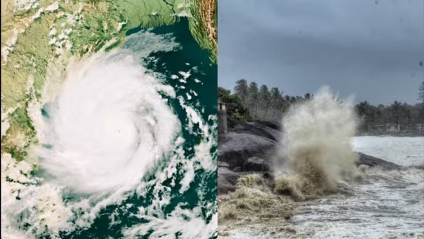
Under the influence of the cyclonic storm, sea conditions are likely to be rough to very rough along and off the Gujarat-North Maharashtra coast until Sunday.

Cyclone Shakhti is the first cyclonic storm of the post-monsoon season in the Arabian Sea(Hindustan Times)
The India Meteorological Department (IMD) on Saturday issued a ‘yellow alert’ for heavy rain and thunderstorms over several districts of Maharashtra ahead of Cyclone Shakhti.
Check Maharashtra districts under ‘yellow alert’?
The weather agency has predicted thunderstorms accompanied by lightning and rainfall for Saturday, October 4, over the following districts:
- Sindhudurg
- Ahilyanagar
- Ghats of Kolhapur
- Kolhapur
- Sangli
- Sholapur
- Parbhani
- Beed
- Hingoli
- Nanded
- Latur
- Dharashiv
- Bhandara
- Nagpur
- Yavatmal
Wind speeds of 30-40 kilometres per hour are expected over these districts.
For Chandrapur, Gadchiroli, and Gondia, the IMD has issued a yellow alert for two days – Saturday and Sunday.
Impact Expected:
According to the Met Department, the thunderstorm warning in the aforementioned districts may have the following impact:
• Possibility of cloud-to-ground lightning at isolated places.
• Fall of weak trees or weak structures due to gusty winds.
- Weather today: IMD issues rain alert for Delhi, Bihar, Himachal Pradesh; Cyclone Shakti to impact these areas
- Weather alert! IMD issues heavy rain alert for THESE districts – check forecast for Delhi, Mumbai and other states
- Ahmedabad on rainfall alert as Cyclone Shakti approaches; IMD issues warning till…
Cyclone Shakti: IMD issues yellow alert for heavy rains for THESE Maharashtra districts – check full list
Under the influence of the cyclonic storm, sea conditions are likely to be rough to very rough along and off the Gujarat-North Maharashtra coast until Sunday.
Published 4 Oct 2025, 02:54 PM IST

Cyclone Shakhti is the first cyclonic storm of the post-monsoon season in the Arabian Sea(Hindustan Times)
The India Meteorological Department (IMD) on Saturday issued a ‘yellow alert’ for heavy rain and thunderstorms over several districts of Maharashtra ahead of Cyclone Shakhti.
Under the influence of the cyclonic storm, sea conditions are likely to be rough to very rough along and off the Gujarat-North Maharashtra coast until Sunday.
Also Read | Cyclone Shakti live updates: Heavy rain alert for Mumbai; where is it right now?
Check Maharashtra districts under ‘yellow alert’?
The weather agency has predicted thunderstorms accompanied by lightning and rainfall for Saturday, October 4, over the following districts:
- Sindhudurg
- Ahilyanagar
- Ghats of Kolhapur
- Kolhapur
- Sangli
- Sholapur
- Parbhani
- Beed
- Hingoli
- Nanded
- Latur
- Dharashiv
- Bhandara
- Nagpur
- Yavatmal
Also Read | Mumbai braces for Cyclone Shakti impact; heavy rain expected by…
Wind speeds of 30-40 kilometres per hour are expected over these districts.
For Chandrapur, Gadchiroli, and Gondia, the IMD has issued a yellow alert for two days – Saturday and Sunday.
Impact Expected:
According to the Met Department, the thunderstorm warning in the aforementioned districts may have the following impact:
• Possibility of cloud-to-ground lightning at isolated places.
• Fall of weak trees or weak structures due to gusty winds.
• Localised and short-term disruption of power.
• Damage to crops due to unseasonal rainfall.
• Strong wind/hail may damage the plantation, horticulture, and standing crops.
• Minor damage to kutcha houses/walls and huts.
Also Read | Ahmedabad on rain alert as Cyclone Shakti approaches; IMD issues warning till…
The IMD advises against working in open areas and fields during thunderstorms and recommends not taking shelter under tall trees or structures. It is also recommended to unplug all electronic appliances and keep them away from objects that conduct electricity.
The weather office has warned fishermen not to venture into the northwest Arabian Sea, the adjoining areas of the northeast Arabian Sea, the central Arabian Sea, and along and off the Gujarat-north Maharashtra coasts until Tuesday.
About Cyclone Shakhti
Cyclone Shakhti is the first cyclonic storm of the post-monsoon season in the Arabian Sea, which is churning up the sea, packing a wind speed of 100 kmph and gusting, officials said.
Shakhti, which has intensified into a severe cyclonic storm, was moving further into the Arabian Sea and lay centred about 420 km away from Dwarka in Gujarat, the weather office said.
It is likely to move west-south westwards and reach the northwest and adjoining west-central Arabian Sea by Sunday, the India Meteorological Department (IMD) said, adding that Shakhti will recurve and move east-northeastwards from Monday morning, weakening gradually.