India’s river systems are usually described as following a clear pattern. Most major rivers rise in the Himalayas or the central highlands and travel eastward to the Bay of Bengal, a rule taught early in geography lessons and seldom challenged. Yet one notable river defies this logic. Flowing westward across the subcontinent, it reshapes landscapes, livelihoods, and belief systems along its course. Far from obscure or insignificant, this river is long, deeply revered, and extensively studied, though its direction often surprises first-time learners. The Narmada stands apart not for its size or speed alone, but because its westward journey is dictated by geology rather than convention. This geological defiance has influenced settlement patterns, pilgrimage routes, dam construction, ecological debates, and identities for centuries across western India. The Narmada river flows in the opposite direction and here’s why river that flows west instead of east. It is the fifth-longest river in India, spanning around 1,310 kilometres.
Narmada river
Narmada, also known as Rewa, is a river in the central India. It is India’s fifth longest river and the third longest river, flowing within India is referred as the “Life Line of Madhya Pradesh” for its huge contribution to the state. The river further flows and drains through the Gulf of Khambhat into the Arabian Sea, in the west of Bharuch city of Gujarat.
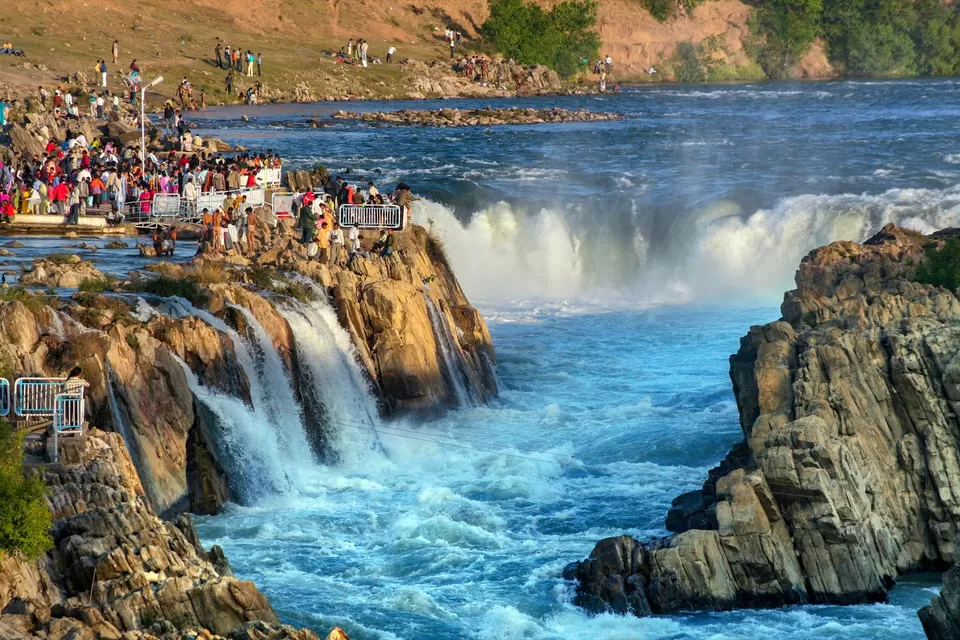
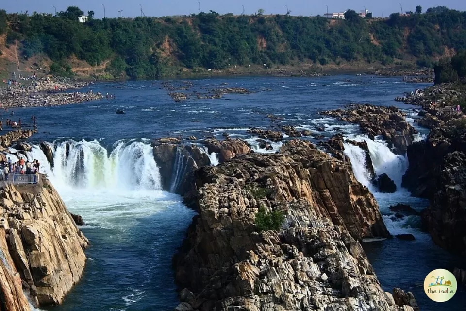
It has numerous waterfalls, notably the Dhuandhar Falls, southwest of Jabalpur.
As per the Hindu mythology, Narmada sprang from the body of Lord Shiva, and in sanctity the Narmada ranks after only the Ganges.

narmada dam
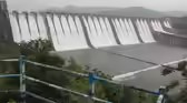
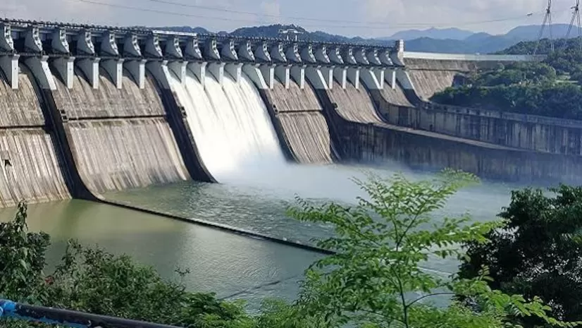
The Narmada Dam or Sardar Sarovar Dam, as known locally, is a gravity dam built across the Narmada river near Navagam in Gujarat. The dam is a part of the Narmada Valley Project, a large hydraulic engineering project involving the construction of a series of large irrigation and hydroelectric multi-purpose dams over the Narmada River. The project took form in 1979 as part of a development scheme to increase irrigation and produce hydroelectricity.
Soon after the project started in 2006, social activist Medha Patkar started The Narmada Jal Satyagraha in Madhya Pradesh opposed increasing the water level of the Sardar Sarovar Dam, which resulted in the destruction of villages. She had raised concerns about the tribes, who were to be displaced from their homes, without a concrete rehabilitation plan in place.
Gujarat remains the greatest intended beneficiary of the Narmada project after Madhya Pradesh in terms of increased irrigation; and after Madhya Pradesh and Maharashtra in hydroelectricity. However, the bulk of the displaced along the Narmada river are in Madhya Pradesh, with the project’s ambit of 30 dams. The Sardar Sarovar dam (commonly referred to as the Narmada dam) in Gujarat near its border with Maharashtra is the biggest. Modi at the time was insistent that the height of this dam be raised to 121.92 metres.
Over the years, the dam’s height has been periodically raised after review by the apex Narmada Control Authority (NCA). That has accompanied much wrangling in the Supreme Court over the persistently vexed issue of shabby resettlement and rehabilitation, or R&R, of those continually displaced by every raising of the dam’s height, and their homes and livelihoods submerged even as that very submergence has been projected as providing greater benefits in irrigation and hydroelectricity.
The origin of the Narmada River
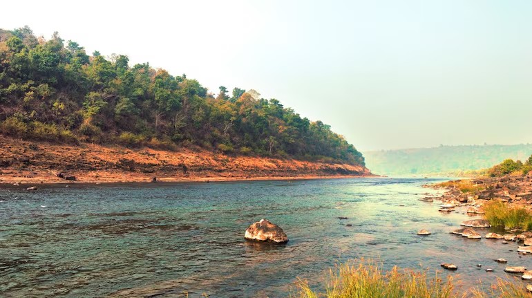
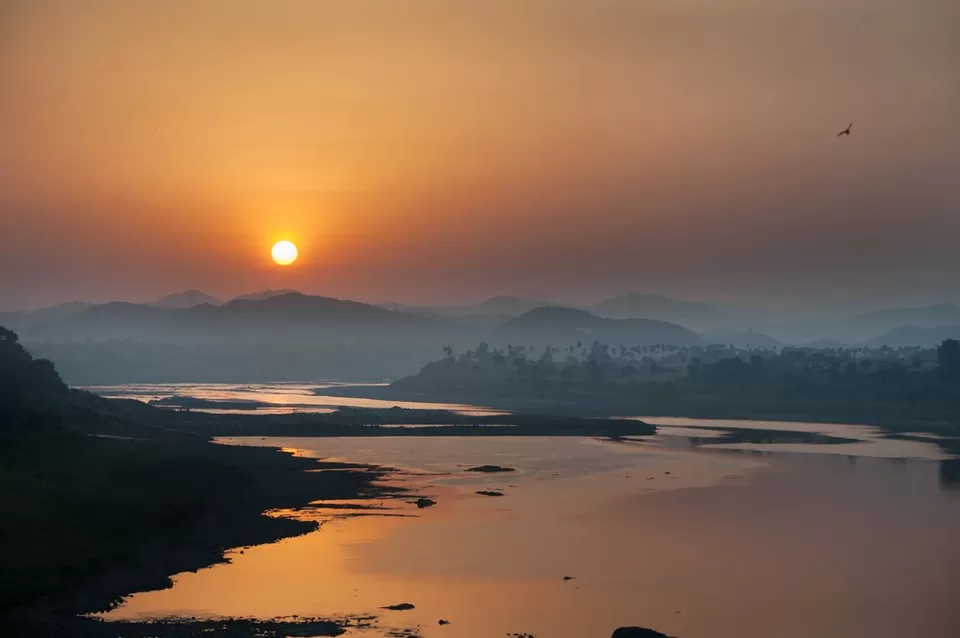
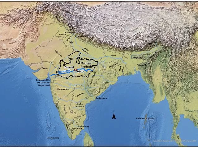
The Narmada River begins near Amarkantak in Madhya Pradesh. The place is forested and used as a pilgrimage spot. From here, the river starts to travel west. It travels through Madhya Pradesh, briefly spans Maharashtra, and then enters Gujarat. Its journey concludes in Bharuch, when it reaches the Arabian Sea. The river’s character changes as it travels. In some places, it cuts through hills and small valleys, while in others, it widens out and slows. The upper stretches feel solitary, while the lower ones feel settled. Dams, towns, temples, agriculture, and monsoon patterns all have an impact on the livelihoods, ecosystems, and cultural rhythms of millions of people. Geology shapes the Narmada’s flow direction. It flows across a rift valley caused by previous tectonic action. The valley slopes east to west. Water follows the slope. The Vindhya Range sits to the north of the basin, while the Satpura Range extends to the south. Because the river passes through this gap, it behaves differently than many others. It does not form a wide delta. Instead, it creates an estuary where it joins the sea. The Narmada basin covers varied terrain. While the upper areas are hilly and forested, with less people living nearby, the land becomes flatter and more open when you go further west. These plains are fertile. Farming depends heavily on the river here. Crops such as wheat, pulses, and cotton are common. The river also supplies drinking water. Over time, canals and reservoirs have extended its reach. Towns and cities along the river rely on it in quiet, everyday ways.
Dams and projects that lie on the river
Several large dams have been built along the Narmada. The Sardar Sarovar Dam in Gujarat is the most widely known. Others include the Indira Sagar Dam and the Omkareshwar Dam in Madhya Pradesh. These projects generate electricity and supply water for farming and households. They have also changed how the river flows. Over the years, they have been linked to debates about land, displacement, and environmental impact. These discussions continue.
Natural sites found along the Narmada
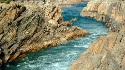
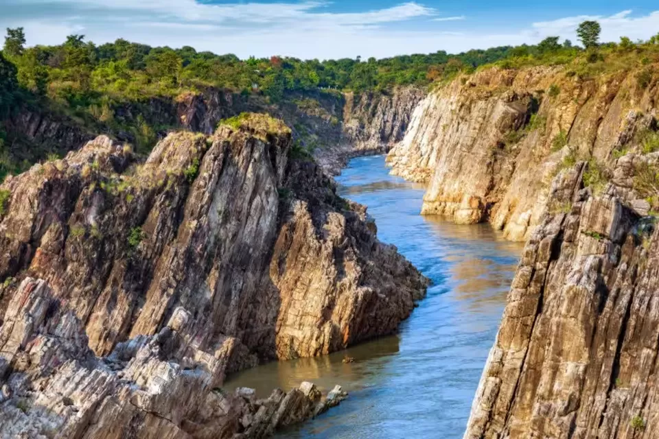
The river is also related with well-known natural landmarks. It goes near Jabalpur between the Marble Rocks, which are tall marble cliffs. Dhuandhar Falls, located nearby, sends water rushing down in a dense spray, particularly during the monsoon season. Although these locations are not large, they leave an impression. The river here feels constrained. The sound carries. The landscape keeps it in place.
Narmada and its importance for faith and culture
For numerous individuals, the Narmada signifies more than merely a river. Temples in Maheshwar, Omkareshwar, and Amarkantak attract pilgrims year-round. Some individuals undertake the Narmada Parikrama, an extensive pilgrimage along its banks. The river is regarded as a living entity. Its trajectory has remained consistent across generations. Throughout its extent, faith, establishment, and customary practices persist in expanding around it. Throughout its history, India was intermittently disturbed by incursions from beyond its northern mountain wall. India, officially known as the Republic of India, is a country that occupies the greater part of South Asia. It consists of 28 states and 8 union territories, with New Delhi serving as its national capital. New Delhi was constructed in the 20th century, located just south of Old Delhi, to serve as India’s administrative center.
India’s government operates as a constitutional republic, representing a highly diverse population with thousands of ethnic groups and hundreds of languages. The official language of the Indian central government is Hindi, and English is also officially designated for government use.
Buddhism
Buddhism arose in India during a time of discontent with Brahmanic (Hindu high-caste) sacrifice and ritual. The religion is constituted by the presence of a charismatic teacher, the teachings that leader promulgated, and a community of adherents that was often made up of renunciant members and lay supporters. This pattern is reflected in the Triratna\u2014i.e., the \u201cThree Jewels\u201d of Buddha (the teacher), dharma (the teaching), and sangha (the community). Buddhist teaching and practice are designed to acquaint people with their true nature so they can free themselves from craving for existence to attain nirvana.
Jainism
Jainism is believed to have originated in the 7th\u20135th century BCE in the Ganges basin of eastern India. Jains believe that their tradition does not have a historical founder. The first Jain figure for whom there is reasonable historical evidence is Parshvanatha, a renunciant teacher who may have lived in the 7th century BCE. The Jain religious goal is the complete perfection and purification of the soul, which they believe occurs only when the soul is in a state of eternal liberation from corporeal bodies. The Three Jewels constitute the basis of the Jain doctrinal and ethical stance: right knowledge, faith, and practice. Missionaries also helped spread the tradition into Southeast Asia, reaching Java by the 5th century CE.
Trade routes The Silk Road, a network of trade routes connecting Asia with the Middle East and Europe, facilitated the movement of Buddhist monks and texts. This allowed Buddhism to reach Central Asia, including Gandhara, in modern Pakistan, where Buddhism interacted with Hellenistic and Roman cultural and artistic influences. From Central Asia, Buddhism spread into Tibet, China, and eventually Korea and Japan. The interaction with different cultures along these routes led to the adaptation and integration of local customs and beliefs into Buddhist practices, enriching its diversity. By the 12th century, Buddhism had virtually disappeared from India but was thriving throughout much of the rest of Asia.
Evolving traditions As Buddhism evolved, multiple branches developed, each with distinct emphases, philosophies, and practices. India has a river that flows backwards: Know which river it is India’s river systems are usually described as following a clear pattern. Most major rivers rise in the Himalayas or the central highlands and travel eastward to the Bay of Bengal, a rule taught early in geography lessons and seldom challenged. Yet one notable river defies this logic. Flowing westward across the subcontinent, it reshapes landscapes, livelihoods, and belief systems along its course. Far from obscure or insignificant, this river is long, deeply revered, and extensively studied, though its direction often surprises first-time learners. The Narmada stands apart not for its size or speed alone, but because its westward journey is dictated by geology rather than convention. This geological defiance has influenced settlement patterns, pilgrimage routes, dam construction, ecological debates, and identities for centuries across western India.
The Narmada river flows in the opposite direction and here’s why
The Narmada is the river that flows west instead of east. It is the fifth-longest river in India, spanning around 1,310 kilometres. The Narmada River does not empty into the Bay of Bengal like the Ganga or Godavari do. It travels steadily westward from its source until it eventually reaches the Arabian Sea.
The Tapi is another prominent example of the few big Indian rivers that follow this path. The idea that the Narmada runs “backwards” originates from the fact that the majority of the region’s rivers flow in the opposite direction, eastward.
The origin of the Narmada River
The Narmada River begins near Amarkantak in Madhya Pradesh. The place is forested and used as a pilgrimage spot. From here, the river starts to travel west. It travels through Madhya Pradesh, briefly spans Maharashtra, and then enters Gujarat. Its journey concludes in Bharuch, when it reaches the Arabian Sea. The river’s character changes as it travels. In some places, it cuts through hills and small valleys, while in others, it widens out and slows. The upper stretches feel solitary, whereas the lower ones are mostly settled. Dams, towns, temples, agriculture, and monsoon patterns, are some of the factors that have an impact on the livelihoods, ecosystems, and cultural rhythms of millions of people.
The reason why the Narmada flow westwards
Geology shapes the Narmada’s flow direction. It flows across a rift valley caused by previous tectonic action. The valley slopes east to west. Water follows the slope. The Vindhya Range sits to the north of the basin, while the Satpura Range extends to the south. Because the river passes through this gap, it behaves differently than many others. It does not form a wide delta. Instead, it creates an estuary where it joins the sea. The Narmada basin covers varied terrain. While the upper areas are hilly and forested, with less people living nearby, the land becomes flatter and more open when you go further west. These plains are fertile. Farming depends heavily on the river here. Crops such as wheat, pulses, and cotton are common. The river also supplies drinking water. Over time, canals and reservoirs have extended its reach. Towns and cities along the river rely on it in quiet, everyday ways.
Dams and projects that lie on the river
Several large dams have been built along the Narmada. The Sardar Sarovar Dam in Gujarat is the most widely known. Others include the Indira Sagar Dam and the Omkareshwar Dam in Madhya Pradesh. These projects generate electricity and supply water for farming and households. They have also changed how the river flows. Over the years, they have been linked to debates about land, displacement, and environmental impact. These discussions continue.
Natural sites found along the Narmada
The river is also related with well-known natural landmarks. It goes near Jabalpur between the Marble Rocks, which are tall marble cliffs. Dhuandhar Falls, located nearby, sends water rushing down in a dense spray, particularly during the monsoon season. Although these locations are not large, they leave an impression. The river here feels constrained. The sound carries. The landscape keeps it in place.
Narmada and its importance for faith and culture
For numerous individuals, the Narmada signifies more than merely a river. Temples in Maheshwar, Omkareshwar, and Amarkantak attract pilgrims year-round. Some individuals undertake the Narmada Parikrama, an extensive pilgrimage along its banks. The river is regarded as a living entity. Its trajectory has remained consistent across generations. Throughout its extent, faith, establishment, and customary practices persist in expanding around it. While the majority of India’s major rivers (such as the Ganga, Godavari, and Krishna) flow eastward to the Bay of Bengal, the Narmada flows westward from its origin in the east to the Arabian Sea.
Key Facts About the Narmada River
The Narmada River previously also known as the Narbada or anglicised as Nerbudda, is the 5th longest river in India and overall the longest west-flowing river in the country. The river descends from Sonmuda, then falls over a cliff as the Kapildhara waterfall, and meanders, in the hills, flowing through a tortuous course crossing the rocks and islands, up to the ruined palace of Ramnagar. Beyond this point up to its meeting with the Arabian Sea, the Narmada enters three narrow valleys between the Vindhya scarps in the north and the Satpura range in the south. The southern extension of the valley is wider at most places. The banks are about (12 m (39.4 ft)) high. It is in the first valley of the Narmada that many of its important tributaries from the south join it and bring the waters of the northern slop. An old channel of the river, 1 km (0.6 mi) to 2 km (1.2 mi) south from the present one, is very clear below Bharuch. The Karanjan and the Orsing are the most important tributaries in the original course. The tidal rise is felt up to 32 km (19.9 mi) above Bharuch, where the neap tides rise to about a metre and spring tide 3.5 m (11.5 ft). The river is navigable for vessels of 95 tonnes (i.e., 380 Bombay candies) up to Bharuch and for vessels up to 35 tonnes (140 Bombay candies) up to Shamlapitha or Ghangdia. The small vessels (10 tonnes) voyage up to Tilakawada in Gujarat. The basin covers large areas in the states of Madhya Pradesh (82%), Gujarat (12%) and a comparatively smaller area in Maharashtra (4%) and in Chhattisgarh (2%). 60% of the basin is made up of arable land, 35% is forest cover and 5% is made up of other types of land such as grassland or wasteland. In the entire course of the river of 1,312 km (815.2 mi), there are 41 tributaries, out of which 22 are from the Satpura range and the rest on the right bank are from the Vindhya range. Like the Ganges, the Narmada River is a goddess and a river in Hinduism. There are many stories about the origin of the Narmada River. According to the Rewa Khand, the Narmada was created from Shiva’s perspiration while he was performing penance on Mount Riksha. Due to this, the Narmada River is known as Shiva’s daughter. They are believed to be the personified form of Shiva and there is a popular saying, “Narmada Ke Kanker utte Sankar” which means that ‘Shiva is in the pebbles of Narmada’. The pebbles are made up of white quartz and are linga shaped.
Uttarvahini Panchkoshi Narmada Parikrama (literally “Northward-flowing 5- Narmada Circumbulation”), is a yearly month-long a significant religious pilgrimage dedicated to the Narmada River, spans a 14-kilometer path beside the Narmada River in Gujarat’s Narmada region on a stretch of the river is notable for its unusual northward flow, a direction considered exceptionally sacred in Hindu beliefs. Pilgrims traditionally traverse this route on foot, visiting important riverbanks known as ghats, including Shaherav Ghat, Rengan Ghat, Rampura Ghat, and Tilakwada Ghat. More than just a physical act of walking around the river, this parikrama offers an immersion into the cultural heritage of central India, providing insights into the local ways of life, customs, and religious observances. The Puranas state, “Ganga Snane, Yamuna Paane, Narmada darshane, Tatha Taapi Smarane” meaning “liberation is attained by bathing in the Ganges, drinking the water of the Yamuna, having darshan of the Narmada, and remembering the Tapi”, i.e. “while bathing in the Ganges and drinking Yamuna’s water are sacred, merely having darshan of the Narmada is believed to bestow liberation”. The importance of the Narmada River as sacred is testified by the fact that the pilgrims perform a holy pilgrimage of a parikrama or circumambulation of the river. The Narmada Parikrama, as it is called, is considered to be a meritorious act that a pilgrim can undertake.
The Uttarvahini Narmada Parikrama, a significant pilgrimage, involves a 14-kilometer circumambulation along the Narmada River. This journey can commence at either the Rampura ghat or Tilakwada. Starting from Rampura ghat, pilgrims proceed along the riverbank towards Tilakwada, crossing a temporary bridge at Saherav before arriving at Rengan ghat. To complete the circle, they then cross the river by canoe. Alternatively, the parikrama can begin in Tilakwada, leading devotees through Rengan and Rampura, then via Saherav, ultimately returning to Tilakwada. Regardless of the starting point, the devotees traverse a seven-kilometer stretch on each side of the river, totaling the 14-kilometer sacred walk. The development of the Narmada river has led to the inundation of some archaeological and architectural sites. The Department of Archaeology, Museums and Archives, Government of Madhya Pradesh, undertook rescue excavations in response, and transplanted a number of temples. An attempt to comprehensively list and publish lost sites has been undertaken by Jürgen Neuss. Many Dinosaur fossils have been found in the Narmada valley.
Water dispute
Investigations for harnessing the Narmada waters began in 1945 to 1946 by A. N. Khosla who was the chairman of the Central Waterways, Irrigation and Navigation Commission (CWINC). In 1948 the Khosla Committee recommended that further investigations be carried out on four of the seven proposed sites. The four sites included Tawa, Bargi, Punasa and the Broach Barrage and Canal Project. In 1951 CWNIC was renamed Central Waterways & Power Commission (CWPC) and in 1957 a senior member of the CWPC selected further investigations to be completed at Navagam, a site that fell under the Broach Project. Navagam eventually became CWPC’s preferred site because the geography allowed the dam’s height to be raised higher. In 1960, the federal Government of India’s Ministry of Irrigation and Power consultant team recommended that the Navagam Dam height be raised in one phase and that the drought prone areas in then Bombay State (modern day Saurashtra and Kutch regions) receive irrigation. The Navagam Dam site and Broach Project fell under the newly formed State of Gujarat and further development and planning was given to the Gujarat State government. The Gujarat State government began planning studies for harnessing Narmada’s water past the Punasa site in Madhya Pradesh. At the same time, the Government of Madhya Pradesh was also finalising a separate report for the Punasa Project. This began inter-State conflicts that went on for several years until 1963 when the Chief Ministers of Madhya Pradesh and Gujarat arrived at a set of compromises called the Bhopal Agreement. Gujarat State ratified the agreement but Madhya Pradesh did not, which led to another impasse. After ten years of deliberations and taking into consideration the development of the water resources of the basin as a whole, the NWDT gave its verdict after assessing all the reports. Even though the tribunal award resolved the initial issue of water sharing, the height of dam, benefit sharing and the mode of settlement of affected people caused serious difficulties in implementation, particularly of the Sardar Sarovar dam. The movement created worldwide attention to the major development activity planned in the valley. This resulted in the Bank conducting an Independent Review Mission (IRM) in 1991 of the Sardar Sarovar Project and identified several recommendations. Finally the Government of India decided to terminate further drawing from the World Bank loan and would complete the project with national resources.
The Supreme Court has also deliberated on this issue for several years but finally upheld the Tribunal Award and allowed the construction to proceed, subject to conditions. The Court introduced a mechanism to monitor the progress of resettlement pari passu with the raising of the height of the dam through Grievance Redressal Authorities (GRA) in each of the party states. The court’s decision referred in this document, given in the year 2000, after 7 years of deliberations, has paved the way for completing the project to attain full envisaged benefits. The Indira Sagar Project (ISP) at Punasa is one of the 30 major projects proposed in the Narmada basin with the largest storage capacity in the country. The project is located near Punasa village, in Khandwa District, Madhya Pradesh. This Multipurpose River Valley Project envisages construction of a concrete gravity dam, 653 metres (2,142 ft) long and 92 metres (302 ft) high with gross storage capacity of the reservoir of 12.22 km3 (9,910,000 acre⋅ft) and live storage of 9.75 km3 (7,900,000 acre⋅ft) to provide an annual irrigation potential of 1,690 km2 (650 sq mi) and a generation of 1000 MW of hydropower. The project also ensures supply of 60,000 acre⋅ft (74,000,000 m3) of drinking water to rural areas in Khandwa district. In accordance with NWDT award, an annual regulated flow of 8,120,000 acre⋅ft (10.02 km3) shall be released to the Sardar Sarovar Project (SSP), ex-Maheshwar Project. The operation of Indira Sagar Project will be carried out in such a way as to facilitate the regulation of Sardar Sarovar.
The dam and the powerhouse have been completed, but storage has been restricted up to EL 260 m under orders of the High Court, Jabalpur from R&R consideration. All the units of the powerhouse have been commissioned and generation of power from the eight units of 125 MW capacity, each commenced from January 2004. The irrigation component of the project is under a fairly advance stage of implementation.
Length: Stretching approximately 1,312 kilometres, it is the fifth-longest river in India and the longest west-flowing river.
States Covered: It flows through Madhya Pradesh, Maharashtra, and Gujarat.
Mouth: It empties into the Arabian Sea through the Gulf of Khambhat near Bharuch, Gujarat. A river in India flows backwards, breaking geographical rules, know where it is most Indian rivers rush east, the Narmada quietly moves west, shaped by ancient geology, sustaining farms, faith, and cities, and challenging what geography lessons long taught for generations today.
India’s river geography is often described as predictable and orderly. Most major rivers rise in the Himalayas or central highlands and flow eastward toward the Bay of Bengal. One river, however, quietly defies this familiar pattern. The Narmada flows west across the Indian subcontinent, shaped by geology rather than convention. Its unusual course continues to draw attention from geographers, historians, and local communities. The river’s direction challenges early textbook lessons while highlighting how landforms guide natural systems across centuries.
The river that flows west instead of east
The Narmada is the river that flows west instead of east. Stretching about 1,310 kilometres, it ranks as India’s fifth longest river. Unlike rivers such as the Ganga or Godavari, it does not empty into the Bay of Bengal. From its source, it follows a steady westward path before reaching the Arabian Sea. Only a few major Indian rivers share this direction, including the Tapi. The idea of the river flowing “backwards” exists only because most Indian rivers flow east. Experts note the river simply follows the natural slope of land.
Origin and geological reason behind the westward flow
The Narmada begins near Amarkantak in Madhya Pradesh. The forested region is also an important pilgrimage site. From here, the river travels west through Madhya Pradesh, briefly crosses Maharashtra, and then enters Gujarat. Its journey ends near Bharuch at the Arabian Sea. Geologists explain the direction is controlled by a rift valley formed by ancient tectonic activity. The valley slopes from east to west. Water naturally follows this gradient. The Vindhya Range lies north of the river basin. The Satpura Range lies to the south. Passing between these ranges, the river forms an estuary instead of a wide delta.
Landscapes, dams and cultural significance
The Narmada basin supports varied landscapes and communities. Upper stretches remain hilly, forested, and sparsely populated. Further west, the terrain becomes flatter and fertile. Agriculture here depends heavily on river water. Wheat, cotton, and pulses are widely grown. Towns and cities rely on the river for drinking water. Several large dams regulate its flow. The Sardar Sarovar Dam is the most prominent. Others include the Indira Sagar and Omkareshwar dams. These projects provide electricity and irrigation but have sparked debates over displacement and environmental impact.
The river is also linked to striking natural sites. Marble Rocks near Jabalpur rise sharply along its banks. Dhuandhar Falls thunder nearby during monsoon months. Beyond geography, the Narmada holds deep spiritual meaning. Pilgrims visit Amarkantak, Omkareshwar, and Maheshwar throughout the year. Some undertake the Narmada Parikrama pilgrimage. For many, the river is viewed as a living presence. Its westward journey has remained constant across generations, shaped by earth, faith, and time.
Why Does It Flow West?
Its unusual direction is primarily due to geology rather than a simple reversal of water:
The Narmada River is one of the major rivers in India that flows westward and drains into the Arabian Sea. This makes it quite unique among Indian rivers, as most major rivers in the country flow eastward and empty into the Bay of Bengal.
The Narmada originates from the Amarkantak Plateau in Madhya Pradesh and flows through the states of Madhya Pradesh, Maharashtra, and Gujarat before finally meeting the Arabian Sea near Bharuch in Gujarat. The river covers a total length of approximately 1,312 kilometers, making it the fifth-longest river in India.
What makes the Narmada special is that it flows through a rift valley, which was formed due to geological movements millions of years ago. This rift valley creates a natural course for the river to flow westward, unlike most other rivers that follow the general slope of the Indian landmass toward the east.
Apart from Narmada, there are a few other rivers that also drain into the Arabian Sea, including the Tapi, Mahi, Sabarmati, and Luni rivers. However, among these, Narmada and Tapi are the two major rivers that flow westward into the Arabian Sea. These westward-flowing rivers are crucial for the western coastal regions of India as they provide water for irrigation, drinking, and various industrial purposes.
- Rift Valley: The Narmada occupies a linear rift valley formed by ancient tectonic activity.
- Natural Slope: The land between the Vindhya Range (north) and the Satpura Range (south) naturally slopes from east to west, forcing the water to follow this gradient.
- No Delta: Because it flows through this rift, it does not form a broad delta but instead ends in a large estuary.
Delhi and other parts of northwest India have been reeling under a Cold Wave since the beginning of 2023.
- The lowest minimum temperature recorded this month was 1.9 degrees Celsius on January 8, the second-lowest minimum temperature in January in 15 years.
- Fog and low cloud coverage brought severe cold day conditions to the region, when temperatures remained below normal over parts of Delhi, Punjab, Haryana, Chandigarh, Himachal Pradesh, Rajasthan, Uttar Pradesh and Madhya Pradesh.
What Factors are Responsible for this Cold Wave?
- Large Scale Fog
According to the India Meteorological Department (IMD)’s State of the Climate Report, the year 2020 was the eighth warmest since India started keeping records in 1901.
- The State of the Climate Report looks at temperature and rainfall trends annually.
Key Points
- Eighth Warmest Year 2020:
- Average Temperature:
- During the year, the annual average temperature in the country was 0.29 degree Celsius (°C) above normal (29-year average from 1981-2010).
- However, it was much lower than 2016 (+0.71 degrees Celsius), which remains the warmest ever year the country has recorded since 1901.
- Such temperature trends were reported despite the cooling effect of La Nina, a global weather pattern that prevailed in 2020 and is linked to substantially below normal temperatures in winter.
- La Nina typically has a cooling effect on global temperatures, but this is now offset by global warming due to greenhouse gas emissions.
- As a result, La Nina years now are warmer than years with El Niño events of the past.
- Warmest Years over India:
- The eight warmest years on record in order were: 2016 (+ 0.71 degree C) > 2009 (+0.55 degree C) > 2017 (+0.541 degree C)> 2010 (+0.539 degrees C) > 2015 (+0.42 degree C)> 2018 (+0.41 degree C)> 2019 (+0.36 degree C)> 2020 (+0.29 degree C).
- The past decade (2011-2020) was the warmest on record.
- Data on Tropical Storms:
- Globally, the Atlantic Ocean experienced one of the most active years, with over 30 tropical storms originating here.
- The Indian Ocean region – the Arabian Sea and the Bay of Bengal, together reported five cyclones.
- Data on Rainfall:The annual rainfall over the country in 2020 was 109% of the Long Period Average (LPA) calculated for the period of 1961-2010.
- Average Temperature:
- What are the Key Highlights of the Forecast?
- India will get Normal Monsoon: India would get 99% of the Long Period Average (LPA) rainfall — changed from 89 cm to 88 cm in 2018, and in the periodic update in 2022, again revised to 87 cm.
- “Normal” to “above Normal” Rainfall:
- Current indications suggest “normal” to “above normal” rainfall in the northern parts of peninsular India, central India and the Himalayan foothills.
- Many parts of northeast India and southern parts of South India are expected to see a subdued monsoon.
- What is the Long Period Average (LPA)?
- According to the IMD, the “LPA of rainfall is the rainfall recorded over a particular region for a given interval (like month or season) averaged over a long period like 30 years, 50 years, etc”.
- The IMD predicts a “normal”, “below normal”, or “above normal” monsoon in relation to a benchmark “Long Period Average” (LPA).
- The IMD has in the past calculated the LPA at 88 cm for the 1961-2010 period, and at 89 cm for the 1951-2000.
- It calculated the LPA at 87 cm for the 1971-2020 period.
- While this quantitative benchmark refers to the average rainfall recorded from June to September for the entire country, the amount of rain that falls every year varies from region to region and from month to month.
- Therefore, along with the countrywide figure, the IMD also maintains LPAs for every meteorological region of the country.
- This number ranges from around 61 cm for the drier Northwest India to more than 143 cm for the wetter East and Northeast India.
- Why is LPA Needed?
- To Smooth Out Trends of Rainfall:
- An LPA is needed to smooth out trends so that a reasonably accurate prediction can be made because the IMD records rainfall data at more than 2,400 locations and 3,500 rain-gauge stations.
- Because annual rainfall can vary greatly not just from region to region and from month to month, but also from year to year within a particular region or month
- What is the Range of a Normal Monsoon?
- The LPA of the season rainfall over the country as a whole for the period 1971-2020 is 87 cm.
- The IMD maintains five rainfall distribution categories on an all-India scale. These are:
- *Normal or Near Normal: When the percentage departure of actual rainfall is +/-10% of LPA, that is, between 96-104% of LPA
- *Below Normal: When departure of actual rainfall is less than 10% of LPA, that is 90-96% of LPA
- * Above normal: When actual rainfall is 104-110% of LPA
- * Deficient: When departure of actual rainfall is less than 90% of LPA
- * Excess: When the departure of actual rainfall is more than 110% of LPA

Cultural and Historical Significance
- Religious Status: In Hinduism, the Narmada is considered one of the holiest rivers, sometimes referred to as the daughter of Lord Shiva.
- Narmada Parikrama: A unique spiritual tradition where devotees walk the entire 2,600 km length of the river on both banks without ever crossing the water.
- Natural Wonders: Notable sites along the river include the Marble Rocks and Dhuandhar Falls near Jabalpur.
- Lifeline: It is vital for agriculture and power, housing major engineering feats like the Sardar Sarovar Dam.
Did You Know That This River in India Flows in the Opposite Direction?
India’s fifth longest river- Narmada river also known as Rewa, is a wonder in itself. While studying Indian Geography, we learnt that most of the major rivers in India flow from west to east, or northwest to southeast because of the influence of the Himalayas and the country’s geology. These rivers flow eastward through the plains before reaching the Bay of Bengal.
Situated in the heartland of India, the Narmada River is an enchanting waterway that meanders through the states of Madhya Pradesh, Maharashtra, and Gujarat. Let’s delve into why the river flows in the backward direction, it’s rich history, cultural significance, and ecological marvels.
The geographical reason for the reverse flow of the Narmada river is the slope of the Rift Valley which is in the opposite direction. Due to this the Narmada flows from east to west and it meets in the Arabian Sea.
Situated in the heartland of India, the Narmada River is an enchanting waterway that meanders through the states of Madhya Pradesh, Maharashtra, and Gujarat. Let’s delve into why the river flows in the backward direction, it’s rich history, cultural significance, and ecological marvels.
Why does Narmada flow in the reverse direction?
The geographical reason for the reverse flow of the Narmada river is the slope of the Rift Valley which is in the opposite direction. Due to this the Narmada flows from east to west and it meets in the Arabian Sea.
Origin and Course of the Narmada river:
The Narmada River originates from the Amarkantak Plateau in Madhya Pradesh, nestled amidst the Vindhya and Satpura mountain ranges. Flowing westward, it covers a distance of approximately 1,312 km before merging into the Arabian Sea near Bharuch, Gujarat.
Mythology and Cultural Significance of the Narmada river:
Holding immense religious and cultural significance, according to Hindu mythology, Narmada is believed to be the daughter of Lord Shiva. Legends narrate that a dip in the sacred waters of the Narmada can wash away sins and purify the soul. It is also associated with the epic tale of the churning of the ocean by gods and demons. It is also said that Narmada was to be married to Sonbhadra but Sonbhadra used to love Narmada’s friend Juhila. Enraged by this, Narmada decided to remain a virgin for life and flow in the opposite direction.
Temples and Pilgrimage Sites on the banks of Narmada:
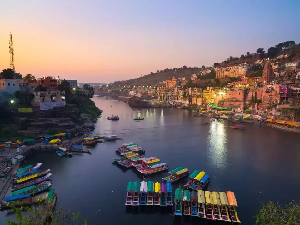
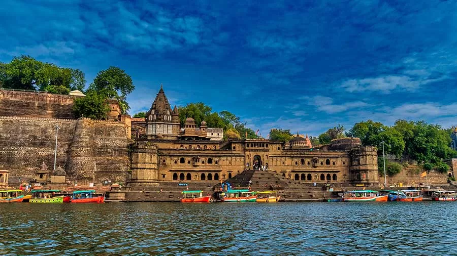
Along the banks of the Narmada River lie numerous temples and pilgrimage sites, attracting devotees from far and wide. Maheshwar, Omkareshwar, and Amarkantak are among the prominent destinations where visitors can immerse themselves in spirituality and witness architectural marvels. These holy sites offer a serene and introspective atmosphere that fosters deep spiritual connections.
Biodiversity and Conservation in the Narmada river:
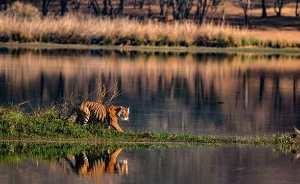
The Narmada River is home to a diverse ecosystem that supports a wide range of flora and fauna. The river basin provides habitats for 4,000+ species of plants, 276+ bird species, 76+ mammal species and 118+ fish species, including the critically endangered gharial, mugger crocodile, and the unique blind dolphin. Conservation efforts have been initiated to preserve the river’s biodiversity, ensuring the sustainable coexistence of human activities and the environment. A third of Narmada’s basin is covered in forests, which support more than 11 Protected Areas including the famous Kanha Tiger Reserve and Panchmarhi Biosphere Reserve.
Dam Projects and Irrigation in the Narmada river:
The Narmada River has been harnessed for irrigation and hydroelectric power generation through various dam projects. The Sardar Sarovar Dam, one of the largest multipurpose dams in the world, has played a significant role in providing water for agriculture, drinking, and industrial purposes.
River Cruises and Adventure Sports in the Narmada river:
For the adventurous souls seeking an adrenaline rush, The city of Jabalpur in Madhya Pradesh, is one of the prominent locations along the Narmada river that offers adventure sports like river rafting, boating and cruises, Parasailing and paragliding, jet skiing and water scooter rides. These experiences allow travellers to witness the river’s beauty up close and create lasting memories.
Where can you find the best views of the Narmada river from?
The Narmada River offers breathtaking views from various locations along its course. Here are some places where you can find the best views of the Narmada River:
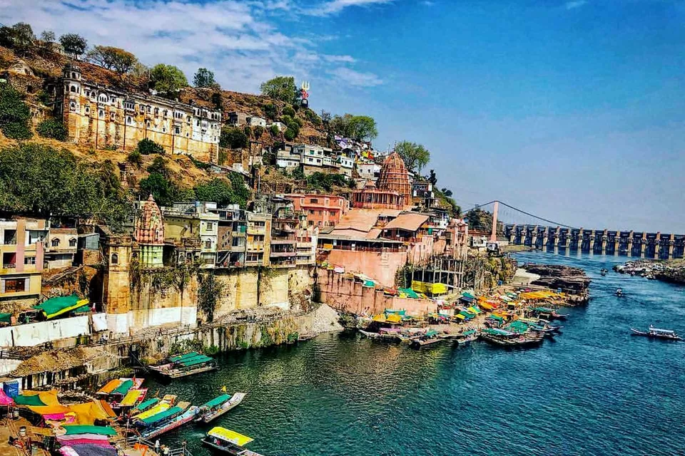
Bhedaghat, Jabalpur: Here, the Narmada River flows through towering marble cliffs, creating a stunning gorge. The Dhuandhar Falls, where the river plunges dramatically, and the Marble Rocks, with their pristine white walls, offer incredible vistas of the Narmada River.
Maheshwar, Madhya Pradesh: The town’s magnificent Maheshwar Fort provides panoramic views of the river and its surroundings. The Ahilyabai Ghat is another spot where you can enjoy picturesque views of the river, especially during sunrise or sunset.
Omkareshwar, Madhya Pradesh: The town’s offers a vantage point to witness the river’s beauty. From here, you can see the river meandering through the scenic landscapes, creating a serene and awe-inspiring sight.
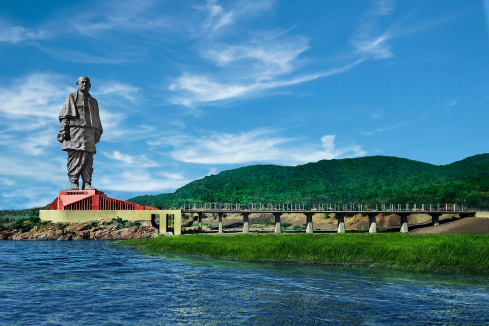
Statue of Unity, Gujarat: Positioned on a river island in the Narmada, the statue offers stunning panoramic views of the river and the surrounding landscape. A viewing gallery near the statue provides visitors with an elevated perspective of the Narmada River.
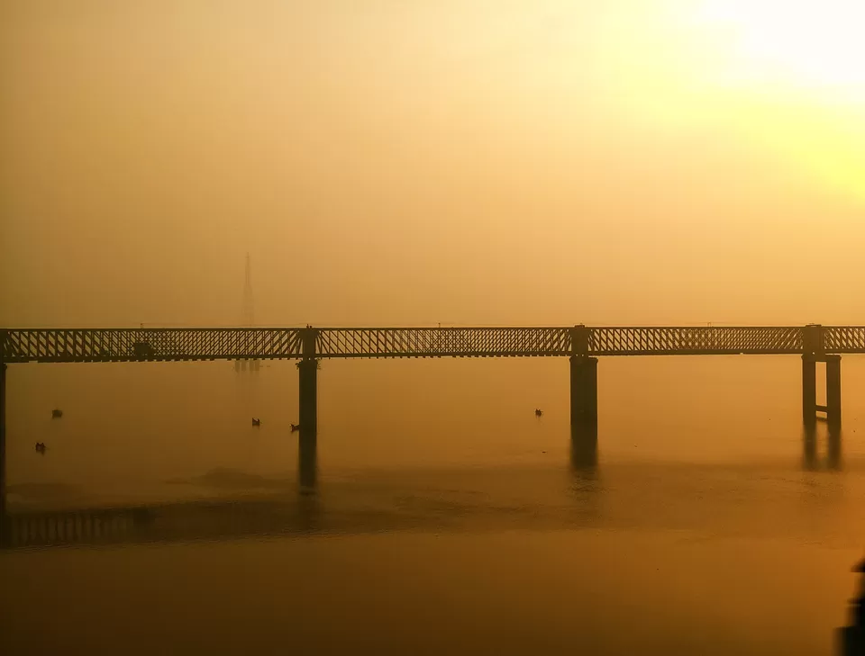
Bharuch, Gujarat: The Golden Bridge, also known as the Narmada Bridge, connects Bharuch with the village of Ankleshwar. Walking on this bridge or viewing it from a distance provides a picturesque view of the river as it nears its final destination.
There are many other viewpoints, ghats, and scenic spots along the river’s course that offer captivating vistas.