A powerful, unseasonal Western Disturbance (WD) that brought historic temperature drops, violent dust storms, and widespread rain across North India is exiting the region by tonight (June 1, 2026). The exit of this storm system marks the end of a rare, winter-like cooling spell in late May, paving the way for clearing skies, a reduction in rainfall, and a gradual return of rising summer temperatures. Rain Relief For North India To End Tonight, Temperatures Will Rise Again A Western Disturbance is a weather system that brings rain, thunderstorms, strong winds, and cooler temperatures to North India.

A western disturbance that brought rain and cloudy weather to parts of north India is expected to move away by Monday night.
The weather conditions are likely to improve, with skies gradually clearing and rainfall activity reducing across several states. The western disturbance had caused scattered showers, thunderstorms and a drop in temperatures in parts of Jammu and Kashmir, Himachal Pradesh, Uttarakhand, Punjab, Haryana and Delhi. “Finally, let’s say goodbye to our great friend, the Western Disturbance, which brought us much-needed relief. It is set to leave the Indian subcontinent by late tomorrow night,” wrote a climate scientist, Dr Pradeep on the social media platform X.
What Is Western Disturbance?
A Western Disturbance is a weather system that brings rain, thunderstorms, strong winds, and cooler temperatures to North India.
It starts near the Mediterranean Sea and moves through countries such as Iran, Afghanistan, and Pakistan. As it travels, it picks up moisture from the seas and surrounding regions. When it reaches the Himalayan mountains, the moist air is forced to rise. As this air rises higher into the atmosphere, it becomes cooler and forms clouds. These clouds can then produce rain, thunderstorms, dust storms, and strong winds, like those seen across North India in recent days. The rising and mixing of warm and cool air make the atmosphere unstable. The weather then suddenly changes from hot and dry to cloudy, windy, and rainy.
Now, the weather system is moving away towards the northeast. Its impact on areas such as Punjab, Haryana, and Delhi-NCR is gradually reducing. However, some moisture is still left in the atmosphere. This means a few places could continue to see light rain or brief showers until Monday, before the weather starts clearing up and temperatures begin rising again.

Similar weather conditions are expected in Punjab till June 5, Haryana, Chandigarh and Delhi till June 4, Uttar Pradesh on June 1, and Rajasthan over the next six days. The department has also warned of thundersqualls, sudden strong winds associated with thunderstorms, in several states. Wind speeds could reach 60-70 kmph, gusting up to 80 kmph, over East Rajasthan on June 2.
Meanwhile, winds of 50-60 kmph, gusting up to 70 kmph, are likely over Jammu and Kashmir from June 3-6, Himachal Pradesh from June 4-6, Delhi-NCR and Haryana on June 4, West Rajasthan on June 2, and East Rajasthan on June 1.
Recent Dynamic Weather Impacts
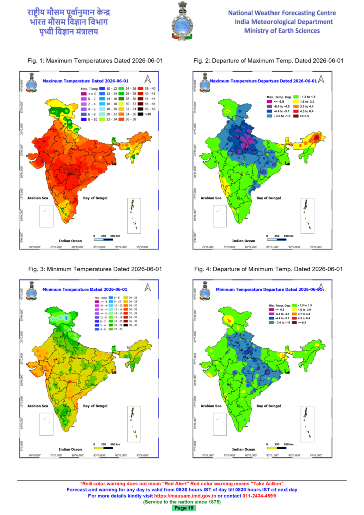
- Historic Temperature Drop: The system completely broke severe heatwaves. Daytime temperatures in places like Chandigarh plunged by up to \(15^{\circ }\text{C}\) below normal to a maximum of just \(25.3^{\circ }\text{C}\), mirroring peak December conditions. Western disturbance to exit north India by Monday night.
- Rain spell ending: The western disturbance will move out of north India by Monday night, ending the recent run of rain, gusty winds, and cooler temperatures.
- From heat to chill: The system broke severe heatwaves, with temperatures plunging up to 15°C below normal, creating winter-like conditions in late May.
- Monsoon watch: With the disturbance gone, attention turns to the southwest monsoon’s progress into Kerala and Tamil Nadu over the next few days.

Western disturbance to exit north India tonight
The India Meteorological Department (IMD) says the western disturbance that has dominated north India’s weather for days will move away by late Monday night. This system, originating over the Mediterranean, travelled across West Asia before hitting the Himalayas, triggering rain, dust storms, and gusty winds. As it shifts northeast, only light to moderate showers are expected in Punjab, Haryana, and Delhi-NCR before skies clear and temperatures start rising again. Goodbye western disturbance: The weather system that swept through North India this week is finally moving on.
This powerful phenomenon, known as a Western Disturbance, which provided a welcome break from the harsh conditions across the region, is set to exit the Indian subcontinent by Monday night.
As it clears the area, residents will see the final signs of its influence before the atmosphere undergoes its next transition.
UNRAVELLING THE WESTERN DISTURBANCE PHENOMENON
Think of it as a low-pressure pocket of air that travels thousands of kilometres from the Mediterranean Sea.
As these systems move eastward, they carry moisture and cooler air across Iran, Afghanistan, and Pakistan before hitting the Himalayas.
When this air arrives, it forces the hot, stagnant air over North India to rise. As this air rises, it cools down and forms clouds, leading to the rain, dust storms, and gusty winds we witnessed over the last few days.
This process, often called cyclogenesis, is the birth of a weather system where low atmospheric pressure draws in surrounding air to create instability. It is this instability that brought the rain we observed, cooling the local environment significantly.
TRACKING THE FINAL SPELLS OF RAINFALL
Delhi-NCR to get fierce rain tonight. Will it bring a winter-like chill? An unusually intense Western Disturbance is moving across Northern India, triggering severe weather warnings. Delhi-NCR and Haryana must brace for sudden thunderstorms, heavy rain and lightning tonight.
Residents of Delhi-NCR and neighbouring Haryana must stay on high alert as a dangerously intense weather system threatens to unleash severe thunderstorms, blinding rain and lightning tonight.
This sudden late May atmospheric shift is already sending shockwaves through the region, transforming peaceful evening skies into active weather zones.
WHAT IS CAUSING TONIGHT’S THUNDERSTORM IN DELHI-NCR?
In 1997, India’s ocean saved the monsoon from El Nino. This year, it won’t one of the strongest El Ninos ever recorded could not break India’s monsoon because the Indian Ocean pushed back. The IOD is flat this year. El Nino is still building. And the September peak is heading straight for India’s standing crops.

The strongest El Nino in decades could not break India’s monsoon in 1997 because the Indian Ocean quietly pushed back. In 2026, the Indian Ocean is sitting completely still.
In 1997, the Pacific Ocean threw one of the worst El Ninos in recorded history at India’s monsoon. Scientists braced for drought. Farmers prepared for the worst. And then, almost inexplicably, India’s rains arrived 2 per cent above normal.
The reason, researchers later pieced together, was that India’s own ocean had intervened.
In 2026, that same ocean has nothing to offer. And the consequences could shape everything from what India grows this year to what it pays at the grocery store.
THE VILLAIN: EL NINO
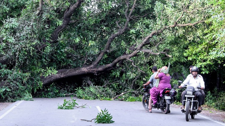
Every few years, something strange happens in the Pacific Ocean. How 4 weather systems will batter North India with violent storms this weekend rare collision of four weather systems is fuelling violent pre-monsoon storms across Delhi, Haryana, Punjab, and Rajasthan this weekend. Here is the science behind the dust storms, hail, and 120 km/h microbursts battering North India on May 30 and 31. Four weather systems are colliding over North India right now. Here is the science behind why the region is in for dust storms, hail, and 120 km/h microbursts this weekend. When four separate weather systems decide to show up at the same party at the same time, things tend to get chaotic. That is precisely what is happening over Northwest India right now, and meteorologists are already warning that the results could be dramatic and, in places, dangerous.
This is not your average pre-monsoon drizzle. This is a textbook severe convective setup, which means the atmosphere has all the right conditions stacked up to produce explosive, rapidly developing thunderstorms. Understanding what is driving it helps explain why dust storms, hail, and potentially terrifying wind gusts are all on the menu for Haryana, North Rajasthan, Punjab, Chandigarh, Delhi, and Uttar Pradesh this weekend.
THE FOUR INGREDIENTS
Think of a violent thunderstorm the way you would imagine a recipe. You need a few key elements in the right quantities, and right now, the atmosphere is well-stocked.
The first ingredient is a Western Disturbance at upper levels. A Western Disturbance is a weather system born far away, over the Mediterranean, Caspian, or Black Sea regions, that travels eastward and eventually reaches the Indian subcontinent.
It moves along what meteorologists call the subtropical westerly jet stream, which is simply a fast-moving river of wind high up in the atmosphere, roughly 8 to 12 kilometres above the ground, that flows from west to east. Most people associate Western Disturbances with winter rains and snowfall in the Himalayas. But in May, one acts more like a trigger, pushing cold air aloft and creating conditions that force the atmosphere to rise sharply over Northwest India.
The second ingredient is a cyclonic circulation over Northwest India. This is a low-level swirling vortex, or the atmosphere spiralling inward near the ground, the same way water spirals as it drains from a bathtub.
This spinning motion draws moisture from all directions and funnels it upward. Think of it as a powerful suction pump for humidity.
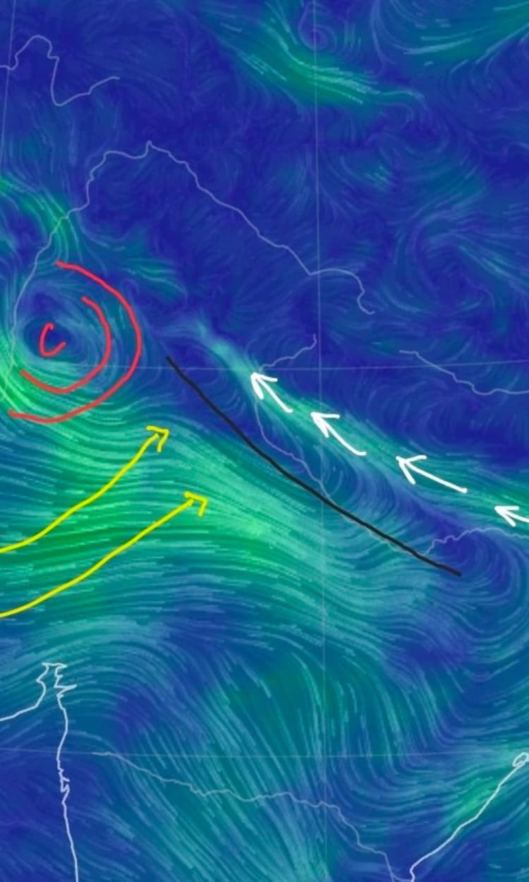
The third and fourth ingredients arrive as moisture from two directions at once. Moist easterly winds from the Bay of Bengal are pushing humid air westward across the Indo-Gangetic Plains, which is the vast flat river basin stretching across northern India from Punjab to Bihar.
At the same time, warm, moisture-laden south-westerly winds from the Arabian Sea are pushing in from the opposite direction. When these two collide over the northern plains, the result is an enormous build-up of water vapour in the atmosphere.
Scientists measure this in terms of Precipitable Water, which is simply the total amount of water vapour present in a column of air above a given point. Right now, those values are unusually high.
THE SCIENCE OF EXPLOSIVE INSTABILITY
Surface temperatures in late May across Rajasthan, Punjab, Haryana, and Delhi routinely climb beyond 43 degrees Celsius. This intense heat warms the air near the ground very rapidly, making it much lighter and less dense than the cooler air higher up.
This creates what meteorologists call steep lapse rates. A lapse rate is simply the rate at which temperature drops as you go higher in the atmosphere.
When the surface is scorching hot and the upper atmosphere is relatively cold, that temperature difference becomes extreme, and the atmosphere becomes deeply unstable, like a pot of water on a high flame that is about to boil over violently.
The key number to watch here is CAPE, which stands for Convective Available Potential Energy.
Think of CAPE as the fuel tank for a storm. It measures how much energy a parcel of hot, humid surface air possesses once it begins rising. The more the CAPE, the more powerfully and rapidly a storm can develop. In this kind of setup, CAPE values can exceed 2,000 to 4,000 joules per kilogram. To put that in perspective, anything above 1,000 joules per kilogram is considered significant.

Values above 2,500 are associated with severe, potentially violent storms. This is what feeds cumulonimbus clouds, which are the towering, dark, anvil-shaped storm clouds capable of punching 12 kilometres or more into the sky and producing everything from lightning to hail to tornadoes.
Adding to all of this is wind shear, a term that simply means the wind changes direction or speed, or both, as you go higher in the atmosphere.
The Western Disturbance provides significant wind shear over North India right now. Wind shear is important because it organises a storm and keeps it alive for longer.
Without shear, a storm’s own rain-cooled downdraft chokes its updraft and the storm dies quickly.
With shear, the updraft and downdraft are separated, allowing the storm to sustain itself for hours and grow into a much more organised and dangerous system.
THE AANDHI: WHEN THE DESERT COMES TO THE CITY
The storm sequence typically begins not with rain but with an aandhi, a word used in Hindi for the dramatic wall of dust that precedes a thunderstorm across the northern plains.
The equivalent term used internationally is a haboob, which refers to a large dust storm generated by the outflow of a thunderstorm.
Here is how it works. As a thunderstorm matures, it produces powerful downdrafts, which are columns of air rushing downward from the storm cloud toward the ground. When this cold, heavy air hits the surface, it has nowhere to go but outward, spreading in all directions like a wave. This spreading mass of cold air is called an outflow boundary or gust front.
As it races away from the storm at speeds of up to 60 kilometres an hour or more, it acts like a bulldozer, scooping up loose, dry soil and sand from Rajasthan and the Thar Desert and hurling it skyward into a towering brown wall.
The results are dramatic and disorienting. Visibility can fall to near zero within minutes. Temperatures can plunge by 10 to 15 degrees Celsius almost instantly. The wind shifts direction abruptly.
And then, as the main body of the storm arrives overhead, the rain follows.
MICROBURSTS: THE SILENT KILLER
The most dangerous element of this weekend’s setup is the microburst, and it deserves careful attention.
A microburst is a sudden, intense downdraft, a column of air that plunges violently downward from a storm cloud and then explodes outward in all directions the moment it hits the ground.
It is typically less than four kilometres wide and lasts only two to fifteen minutes, which is precisely what makes it so dangerous. It appears with almost no warning, strikes a small area with devastating force, and is over before most people have had time to react.
Think of it this way: imagine holding a garden hose directly above a flat surface and turning it on full blast. The water jet hits the surface and sprays outward in every direction. A microburst behaves exactly like that, except instead of water, it is a column of air moving at terrifying speed.
How does a microburst form? When dry air from the middle layers of the atmosphere gets pulled into a thunderstorm, it causes rain and ice particles inside the cloud to evaporate partially and the air to cool rapidly.
This rapid cooling makes the air denser and heavier, causing it to accelerate downward. This is called evaporative cooling.
On top of this, precipitation loading, which simply means the sheer physical weight of rain and hail dragging air downward with it, adds even more downward momentum. The result is a column of air hitting the ground at speeds that can exceed 100 to 150 kilometres an hour locally.
The damage from a microburst is often mistaken for tornado damage because it can be just as severe.
The key difference is that a tornado produces a rotating, circular pattern of destruction, while a microburst produces a starburst or outward spray pattern.
Both can flatten trees, tear roofs off buildings, and bring down power lines.
Independent weather forecaster Navdeep Dahiya warns of gusts between 80 and 120 kilometres an hour with microburst activity, and these numbers are entirely consistent with what this kind of setup produces.
The activity that began over scattered areas on the evening of May 28 is expected to become more widespread through Saturday, May 30 and Sunday, May 31.
Nature is not sending one warning. It is sending four. Without those winds doing their job, warm water drifts back eastward and pools along the coast of South America instead. A large stretch of the central Pacific heats up.
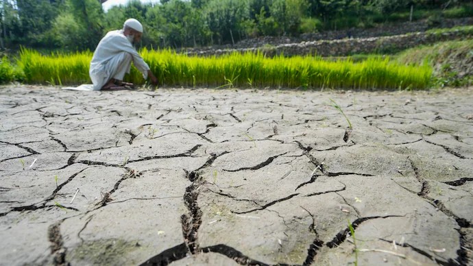
This is El Nino, Spanish for “the little boy,” a name given by South American fishermen centuries ago when they noticed unusually warm waters arriving around Christmas, disrupting their catch. India’s worst monsoon since 2015 could be here. El Nino puts odds at 60% has put the probability of a deficient 2026 monsoon at 60 per cent, nearly four times the historical odds, as El Nino develops in the Pacific and the Indian Ocean offers no counterbalancing force. The forecast, which has already worsened since April, could make 2026 India’s driest monsoon in over a decade.
For two years in a row, India’s monsoon delivered. In 2024 and 2025, the rains came in above normal, reservoirs filled, and farmers got back-to-back good harvests. In 2026, that run is over. IMD, commonly known as the India Meteorological Department, is the country’s principal agency for weather forecasting, meteorological observations and seismology. Established in 1875, the IMD functions under the Ministry of Earth Sciences and is headquartered in New Delhi.
The department plays a crucial role in monitoring India’s weather and climate conditions, issuing forecasts and early warnings for cyclones, heavy rainfall, thunderstorms, heatwaves, cold waves and other extreme weather events. Its alerts are widely used by governments, disaster management agencies, farmers, airlines, shipping companies and the general public.
The IMD is especially known for tracking monsoon patterns, which are vital for India’s agriculture and water resources. Every year, its southwest monsoon forecast is closely watched because nearly half of India’s farmland depends on rainfall for irrigation.
Apart from weather forecasting, the IMD also monitors earthquakes and seismic activity across the country through a network of observatories and weather stations. The department uses satellites, Doppler weather radars, ocean buoys and advanced computer models to improve forecasting accuracy.
Over the years, the IMD has expanded its role in disaster preparedness by issuing timely warnings during cyclones in the Bay of Bengal and Arabian Sea. Improved forecasting has helped reduce casualties during major storms in recent years.
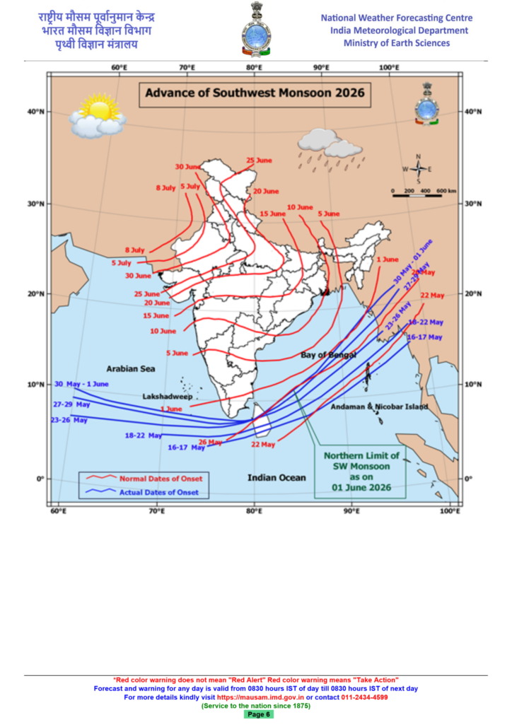
Today, the IMD remains one of India’s most important scientific institutions, serving as the backbone of the country’s weather and climate monitoring system. The Southwest Monsoon is India’s main rainy season and one of the most important weather systems affecting the country’s economy, agriculture and water security. Arriving usually in early June over Kerala, the monsoon spreads across most parts of India by mid-July and continues until September.
The monsoon develops because land areas over northern and central India heat up faster than the surrounding oceans during summer, creating low pressure over the subcontinent. Moisture-laden winds from the Indian Ocean then move towards the land, bringing widespread rainfall. These winds, known as southwesterlies, split into two branches — the Arabian Sea branch and the Bay of Bengal branch.
The Arabian Sea branch brings rain to the western coast and central India, while the Bay of Bengal branch moves towards eastern and northeastern India before spreading into the northern plains. Mountain ranges such as the Western Ghats and the Himalayas force the moist winds to rise, cool and produce rainfall.
Nearly 75 per cent of India’s annual rainfall comes during the Southwest Monsoon season, making it crucial for farming, hydropower, rivers, groundwater and drinking water supplies. Around 64 per cent of Indians depend on agriculture, much of which relies heavily on monsoon rains.
However, the monsoon is highly unpredictable. Delayed arrival, uneven rainfall, floods, droughts and long dry spells can severely affect crops, rural incomes and overall economic growth. The Monsoon season is a significant weather phenomenon that occurs in several parts of the world. It is characterized by a period of intense rainfall and increased humidity. In India, the Monsoon season typically spans from June to September and plays a vital role in the country’s agricultural and economic activities.
The Monsoon season in India is driven by the southwest monsoon winds, which carry moist air from the Arabian Sea and the Bay of Bengal. As these winds encounter the Indian subcontinent’s mountain ranges, they are forced to rise, leading to condensation and the formation of rain clouds. This process results in widespread rainfall across the country.
India heavily relies on the Monsoon season for its agriculture, as the rains nourish crops and recharge water bodies. The success of the agricultural sector during this period directly impacts the country’s food production and economy. However, excessive rainfall can also lead to flooding, causing damage to infrastructure, homes, and crops, and posing a threat to lives.
The timing, duration, and intensity of the Monsoon can vary across different regions, but the fundamental mechanism of seasonal winds and precipitation remains similar.
Overall, the Monsoon season is a crucial natural phenomenon with both benefits and challenges. While it provides much-needed water for agriculture and sustains ecosystems, it also requires careful management to mitigate the risks associated with excessive rainfall and flooding.

That figure alone would make 2026 potentially the driest monsoon in over a decade. But the number that should stop anyone in their tracks is this: the probability of an outright deficient monsoon, which means rainfall that falls below even that already-low threshold, now stands at 60 per cent. The historical odds of such a bad season in any given year are 16 per cent. IMD has nearly quadrupled them in a single forecast. And the force driving all of this, El Nino, has not even reached full strength yet.
WHAT IS EL NINO?
Think of the tropical Pacific Ocean as a giant heat engine. Under normal conditions, strong east-to-west winds push warm surface water westward toward Indonesia and Australia, while cold, nutrient-rich water rises up from the deep ocean along the coast of South America to take its place.
This entire system of wind and ocean circulation is called the Walker Circulation, named after British meteorologist Sir Gilbert Walker who first described it in the early 20th century. It is one of the key engines that keeps the Indian monsoon running on time and in force.
El Nino is what happens when that engine stalls. The winds weaken. Warm water drifts back eastward toward South America. The cold upwelling is suppressed.
A large pool of unusually warm ocean surface temperatures builds across the central and eastern Pacific, and the effects travel outward across the globe, shifting rainfall patterns, rerouting jet streams, and in India’s case, choking off the monsoon.
The mechanism is straightforward. The Indian monsoon is powered by a temperature contrast: as the subcontinent heats up each summer, moist air rushes in from the Indian Ocean to fill the rising column of warm air over land, and that is what brings the rain. El Nino disrupts this by pulling the atmosphere’s areas of convection, the rising columns of warm, moisture-laden air that generate clouds and rainfall, away from South Asia and toward the central Pacific instead.
Less moisture reaches India. Less rain falls. Historically, roughly 60 per cent of El Nino years between 1951 and 2022 saw below-average monsoon rainfall across the country.
THE WORST IS STILL TO COME
According to IMD’s updated long-range forecast issued on May 29, the Pacific is currently transitioning from neutral conditions toward El Nino. The monsoon season is one of the most eagerly awaited times of the year. The monsoon shows up like a guest you’ve been waiting for a long time. The air changes, the sky turns gray, and then the first drops start falling. It feels like the whole world is taking a deep breath after the heat a moment to slow down and soften.
People lean out of their balconies just to watch the rain pour. Kids splash around in puddles, not caring much about umbrellas that never seem to keep them dry. Children run into puddles, ignoring umbrellas that never quite do their job. Streets slow down, traffic jams get longer, clothes refuse to dry yet nobody really complains, because the rain brings its own kind of joy.
There’s something beautiful even in all the mess the rain brings. The sound of raindrops hitting the windows becomes a kind of music for those late-night talks. Taking long walks with an umbrella turns into moments you remember later. Even small things, like sipping hot chai by the window, feel special and poetic during the monsoon.
The monsoon is messy, inconvenient, and unpredictable, but it’s also comforting. After the heat, it feels like nature has pressed reset.
Monsoon in India has a permanent place in Indian culture in songs, poetry, films, and traditional art. From classical music ragas to Bollywood melodies, from folk tales to festivals, rain has been celebrated for generations.
Core Characteristics of a Western Disturbance
[Mediterranean Sea / Atlantic] ---> Gathers Moisture over Caspian / Black Sea ---> Driven by Westerly Jet Stream ---> Hits Himalayas ---> Rain & Snow in North India
- Origin: They are extra-tropical, low-pressure cyclonic storms that originate outside the tropics over the Mediterranean Sea or Atlantic Ocean.
- Travel Mechanism: They travel thousands of kilometres eastward, propelled by high-altitude subtropical westerly jet streams passing over Iran, Afghanistan, and Pakistan.
- Moisture Sources: Along their journey, they gather additional moisture from the Caspian Sea, Black Sea, and the Persian Gulf.
- Precipitation Trigger: When the moisture-laden winds hit the physical barrier of the Himalayas, the air is forced to rise, condense, and fall as rain in the plains and heavy snow in the mountains.
Impact on North Indian Life
| Season | Primary Weather Effects | Impact on Agriculture & Life |
|---|---|---|
| Winter (Nov–March) | Persistent rain in plains, heavy snow in hills, dense fog. | Highly Beneficial: Acts as the primary lifeline for crucial Rabi crops like wheat, mustard, and barley. |
| Summer/Pre-Monsoon | Sudden thunderstorms, violent dust storms, hail, and wind squalls. | Mixed Impact: Temporarily breaks severe heatwaves but poses deadly hazards like crop damage, lightning casualties, and structural loss. |
Climate Change Escalation
Meteorologists point out that while Western Disturbances are a standard winter phenomenon, climate change is shifting their behavior. Warmer atmospheres hold more moisture, leading to much more aggressive, highly erratic, and intense systems during the summer months. This has triggered devastating anomalies, such as severe, fatal hailstorms in the northern plains during peak heat seasons.