Kerala is the 13th-most populous state in India. It is divided into 14 districts, with Thiruvananthapuram as the capital. Kerala is one of India’s most progressive states in terms of social welfare and quality of life.
Onset & Advance of Monsoon
The guidelines to be followed for declaring the onset of monsoon over Kerala and its further advance over the country are enlisted below:
a) Rainfall
If after 10th May, 60% of the available 14 stations enlisted*, viz. Minicoy, Amini, Thiruvananthapuram, Punalur, Kollam, Allapuzha, Kottayam, Kochi, Thrissur, Kozhikode, Thalassery, Kannur, Kudulu and Mangalore report rainfall of 2.5 mm or more for two consecutive days, the onset over Kerala be declared on the 2nd day, provided the following criteria are also in concurrence.
b) Wind field
Depth of westerlies should be maintained upto 600 hPa, in the box equator to Lat. 10ºN and Long. 55ºE to 80ºE. The zonal wind speed over the area bounded by Lat. 5-10ºN, Long. 70-80ºE should be of the order of 15 – 20 Kts. at 925 hPa. The source of data can be RSMC wind analysis/satellite derived winds.
c) Outgoing Longwave Radiation (OLR)
INSAT derived OLR value should be below 200 wm-2 in the box confined by Lat. 5-10ºN and Long. 70-75ºE.
Northern Limit of Monsoon (NLM)
Southwest monsoon normally sets in over Kerala around 1st June. It advances northwards, usually in surges, and covers the entire country around 15th July. The NLM is the northern most limit of monsoon upto which it has advanced on any given day. Monsoon likely to set in over Kerala on June 4, says IMD in latest forecast IMD had earlier predicted the onset of monsoon over Kerala on May 26 the date of arrival does not correlate with the quantum of rainfall, the latter is a cause of concern this year.
The southwest monsoon is now expected to advance into Kerala on June 4, the India Meteorological Department (IMD) said on Tuesday (June 2, 2026). Southwest monsoon to arrive in Kerala in 2-3 days: IMD had earlier predicted the onset of monsoon over Kerala on May 26 southwest monsoon is expected to arrive in Kerala in the next two to three days, the India Meteorological Department said in its forecast on Friday.

Typically, the season begins around June 1.
“Conditions are favourable for further advance of southwest monsoon into some more parts of southwest and southeast Arabian Sea, Lakshadweep Islands, some parts of Kerala and Tamil Nadu during the next two to three days,” the weather department said.
The advance can also take place in some more parts of southwest, west-central, east-central and northeast Bay of Bengal, and remaining parts of southeast Bay of Bengal during the period, it predicted.
The IMD had earlier predicted the onset of monsoon over Kerala on May 26. However, the arrival of monsoon was delayed, and the department stated on May 29 that it could happen the following week.
In its revised forecast last week, the department said the season’s rainfall would be below normal.
It noted that India is expected to receive 90 per cent of its Long Period Average (LPA) this year.
LPA refers to the rainfall recorded over a particular region for a given interval, such as a month or season, averaged over a long period, typically 30 to 50 years. The LPA of seasonal rainfall over India as a whole, based on data from 1971 to 2020, is 87 centimetres.
If a monsoon season sees less than 90 per cent of the LPA rainfall, the IMD classifies it as “deficient”.
One reason behind the below-normal rainfall this year could be the emergence of El Nino conditions, which lead to less rain during monsoon in India, the IMD said.
Currently, neutral El Nino-Southern Oscillation conditions are transitioning towards El Nino conditions over the equatorial Pacific region, it said. El Nino conditions are likely to be weak in June, and moderate to strong in September, it added.
Current Status and Timeline
- Initial Forecast: May 26 (pushed back after missing the window).
- Normal Onset Date: June 1.
- Revised Arrival Expectation: June 2 to June 4.
- Expected Strengthening: Forecasters note the monsoon will likely build up strength gradually and establish a robust flow only after June 5–6.
Monsoon onset in Kerala to be delayed further; here is fresh IMD forecast The IMD says the southwest
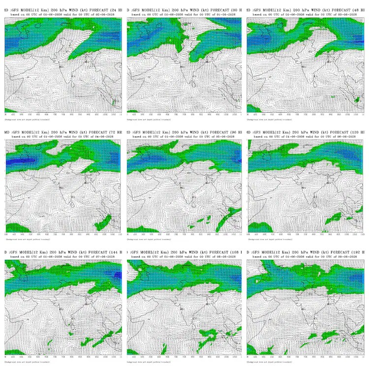
The IMD says the southwest monsoon is likely to strengthen gradually over Kerala after June 5-6 due to weak upper-level winds and a Western Disturbance The latest projections from the India Meteorological Department’s (IMD) weather forecasting model have indicated a further delay in the southwest monsoon gathering strength than previously expected. According to the latest model runs, the strong upper-level winds that typically support a vigorous model runs, the strong upper-level winds that typically support a vigorous monsoon onset are unlikely to become fully established over southern India until after June 5 or 6. Gradual onset Likely This indicates that the monsoon’s arrival over Kerala could be relatively mild rather than marked by a strong surge of rainfall and winds. Instead of a dramatic onset, the seasonal weather system is expected to strengthen gradually over the following days, reported India Today.
The southwest monsoon is one of the most important weather phenomena for India. Between June and September, moisture-laden winds from the Indian Ocean bring the majority of the country’s annual rainfall. These rains are vital for agriculture, help replenish reservoirs and groundwater resources, and provide much-needed relief from intense summer heat.
Reason behind the delay The IMD’s forecasting model, which processes extensive atmospheric data to predict weather patterns several days in advance, indicates that a Western Disturbance currently affecting the region must first move away. This weather system, which originates from the west and carries moisture, is preventing the crucial upper-level easterly winds from strengthening over southern India. Until that happens, monsoon flow into Kerala is expected to remain somewhat weak. The report further stated that the monsoon’s progress this year has been difficult to predict. The IMD had initially expected the monsoon to reach Kerala around May 26, but that forecast has been revised multiple times. Current estimates place the official onset between June 2 and June 4. Conditions yet to align While pre-monsoon showers have already brought rainfall to parts of Kerala, all the conditions required for an official declaration have not yet been met. The IMD requires three criteria to be satisfied simultaneously: sustained rainfall across at least 60 per cent of Kerala’s designated weather stations, sufficiently strong westerly winds over the Arabian Sea, and adequate cloud cover. Currently, although rainfall and cloud cover meet the required standard the westerly winds remain weaker than necessary. Experts attribute this weakness to earlier cyclonic activity in the Bay of Bengal, which disrupted the monsoon circulation. Meteorologists expect these winds to strengthen from June 1. Seasonal concerns persist Although the monsoon appears imminent, concerns remain about the overall season. The IMD has forecast below-normal rainfall for India, lowering its estimate from 92 per cent to 90 per cent of the long-period average due to emerging El Nino conditions. Meanwhile, severe heatwaves continue across northern and central India, making timely rainfall increasingly important for farmers preparing their fields for sowing.
Meteorological Reasons for the Delay
Weather scientists attribute the disruption and stalling of the monsoon winds to three main atmospheric and oceanic factors:
- Weak Westerly Winds: The strong, low-level westerly winds over the Arabian Sea required to push moisture onto the mainland have not fully established.
IMD says southwest monsoon to hit Kerala on June 4
When will it arrive?: IMD now expects the southwest monsoon to reach Kerala on June 4, later than the usual June 1 onset.
Why the delay?: Weak westerly winds, cyclonic activity, and low cloud formation over the Indian Ocean have slowed the monsoon’s advance.
What’s at stake?: Below-normal rainfall of 90% LPA is forecast, raising concerns for agriculture, water supply, and heat relief.

IMD pushes monsoon onset to June 4–6
The IMD announced on June 2 that the southwest monsoon will arrive in Kerala on June 4, after repeated delays from the initial May 26 forecast. Conditions such as sustained rainfall over 60% of key stations, strong westerly winds, and dense cloud cover have not yet aligned. Fresh model assessments suggest strong upper-level winds may only develop after June 5–6, meaning the season could start weak before intensifying.
Key takeaways
- Monsoon Arrival: The southwest monsoon is now expected in Kerala on June 4, delayed from the earlier forecast of May 26. Favorable conditions are expected for further advancement into parts of Arabian Sea, Lakshadweep, Tamil Nadu, and Bay of Bengal regions.
- Rainfall Outlook: This year’s seasonal rainfall is predicted to be below normal, around 90% of Long Period Average (LPA). A weak El Nino may reduce rainfall in June, potentially strengthening by September.
- Impact & Importance: Accurate monsoon timing is crucial for agriculture, water management, and disaster preparedness, helping improve forecast reliability and climate resilience.
The India Meteorological Department on Tuesday, June 2, said that the southwest monsoon will arrive in Kerala on June 4. This was originally forecast for May 26.
In a post from X, the IMD said, “Re-determination of Normal Dates of Monsoon
Understanding the changing behaviour of the Indian Monsoon is crucial for agriculture, water management, disaster preparedness, and climate adaptation.
This study revisits and redefines the “normal” onset and withdrawal dates of the monsoon using updated long-term climatological data and modern statistical analysis.
Key Highlights:Reassessment of monsoon onset and withdrawal patterns across India
Identification of shifting monsoon timelines under changing climate conditions
Improved climatological normals for operational forecasting
Valuable insights for agriculture, hydrology, and disaster management planning
Supports better seasonal forecasting and policy decisions
Why it Matters?
Even small shifts in monsoon timing can significantly impact crop sowing, water resources, urban planning, and extreme weather preparedness. Updated monsoon normals help improve forecast reliability and climate resilience.” “Monsoon forecast is indicating more impact of El Nino. However, the number is not important, but the distribution of rainfall is. Models are not predicting a pretty picture, and we can expect a patchy distribution. There will be more numbers as well as longer break-monsoon conditions.” Monsoon delayed: What does the missing rain mean for different states?
Key takeaways
- Delayed Onset: The southwest monsoon is expected to reach Kerala in 2-3 days, with a robust monsoon likely by June 5-6. Early rains may be weak but will gradually strengthen.
- Weather Impacts: Cyclonic circulations and slow-moving moisture-laden winds are causing volatile weather, including thunderstorms and gusty winds in Northwest and Central India.
- Regional Concerns: – Northwest & Central India: Prolonged heat, higher water demand, delays in sowing crops like soybean and paddy. – Eastern & Southern States: Potential stress on reservoirs, delayed paddy transplantation, and short-term water shortages.
The southwest monsoon is the heartbeat of India. As we look at the calendar, the rain that usually blankets the country is currently taking a detour.
The India Meteorological Department (IMD) has said that the monsoon is expected to set in over Kerala within the next two to three days. Monsoon misses its date with Kerala again, IMD predicts new timeline latest weather model indicates that a strong monsoon may develop only after June 5-6, suggesting a weaker onset over Kerala before rainfall gradually intensifies.

Latest runs of the India Meteorological Department’s weather model indicate that strong upper-level winds essential for a robust monsoon are likely to establish over South India only after June 5-6.
Southwest Monsoon
The Southwest Monsoon is India’s main rainy season and one of the most important weather systems affecting the country’s economy, agriculture and water security. Arriving usually in early June over Kerala, the monsoon spreads across most parts of India by mid-July and continues until September.
The monsoon develops because land areas over northern and central India heat up faster than the surrounding oceans during summer, creating low pressure over the subcontinent. Moisture-laden winds from the Indian Ocean then move towards the land, bringing widespread rainfall. These winds, known as southwesterlies, split into two branches — the Arabian Sea branch and the Bay of Bengal branch.
The Arabian Sea branch brings rain to the western coast and central India, while the Bay of Bengal branch moves towards eastern and northeastern India before spreading into the northern plains. Mountain ranges such as the Western Ghats and the Himalayas force the moist winds to rise, cool and produce rainfall.
Nearly 75 per cent of India’s annual rainfall comes during the Southwest Monsoon season, making it crucial for farming, hydropower, rivers, groundwater and drinking water supplies. Around 64 per cent of Indians depend on agriculture, much of which relies heavily on monsoon rains.
However, the monsoon is highly unpredictable. Delayed arrival, uneven rainfall, floods, droughts and long dry spells can severely affect crops, rural incomes and overall economic growth.
Monsoon
The Monsoon season is a significant weather phenomenon that occurs in several parts of the world. It is characterized by a period of intense rainfall and increased humidity. In India, the Monsoon season typically spans from June to September and plays a vital role in the country’s agricultural and economic activities.
The Monsoon season in India is driven by the southwest monsoon winds, which carry moist air from the Arabian Sea and the Bay of Bengal. As these winds encounter the Indian subcontinent’s mountain ranges, they are forced to rise, leading to condensation and the formation of rain clouds. This process results in widespread rainfall across the country.
India heavily relies on the Monsoon season for its agriculture, as the rains nourish crops and recharge water bodies. The success of the agricultural sector during this period directly impacts the country’s food production and economy. However, excessive rainfall can also lead to flooding, causing damage to infrastructure, homes, and crops, and posing a threat to lives.
The timing, duration, and intensity of the Monsoon can vary across different regions, but the fundamental mechanism of seasonal winds and precipitation remains similar.
Overall, the Monsoon season is a crucial natural phenomenon with both benefits and challenges. While it provides much-needed water for agriculture and sustains ecosystems, it also requires careful management to mitigate the risks associated with excessive rainfall and flooding.
WHAT IS THE LATEST IMD MONSOON FORECAST?
The Global Forecast System (GFS) is a powerful computer model used by the IMD.
The weather forecast model processes vast amounts of atmospheric data to forecast weather patterns several days in advance.
According to its recent outputs, an incoming Western Disturbance, which is a weather system from the west that brings moisture-laden winds, needs to move out before the key upper-level easterly winds can strengthen properly over southern India.
IMD
IMD, commonly known as the India Meteorological Department, is the country’s principal agency for weather forecasting, meteorological observations and seismology. Established in 1875, the IMD functions under the Ministry of Earth Sciences and is headquartered in New Delhi.
The department plays a crucial role in monitoring India’s weather and climate conditions, issuing forecasts and early warnings for cyclones, heavy rainfall, thunderstorms, heatwaves, cold waves and other extreme weather events. Its alerts are widely used by governments, disaster management agencies, farmers, airlines, shipping companies and the general public.
The IMD is especially known for tracking monsoon patterns, which are vital for India’s agriculture and water resources. Every year, its southwest monsoon forecast is closely watched because nearly half of India’s farmland depends on rainfall for irrigation.
Apart from weather forecasting, the IMD also monitors earthquakes and seismic activity across the country through a network of observatories and weather stations. The department uses satellites, Doppler weather radars, ocean buoys and advanced computer models to improve forecasting accuracy.
Over the years, the IMD has expanded its role in disaster preparedness by issuing timely warnings during cyclones in the Bay of Bengal and Arabian Sea. Improved forecasting has helped reduce casualties during major storms in recent years.
Today, the IMD remains one of India’s most important scientific institutions, serving as the backbone of the country’s weather and climate monitoring system. El Nino to hit India during monsoon, last until September, says IMD chief developments are particularly significant because El Nino has historically been associated with weaker monsoon rainfall, frequent heatwaves and increased stress on agriculture and water resources.
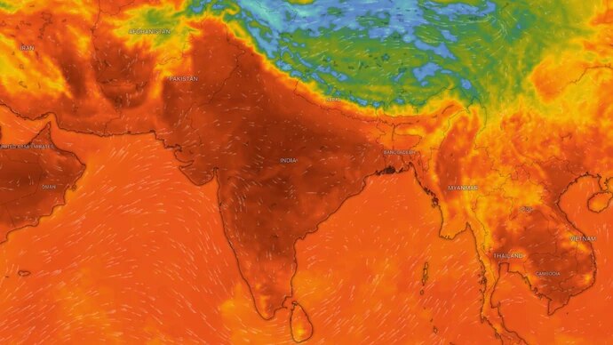
El Nino is confirmed to hit India during the monsoon season, bringing the rainfall levels to the lowest the country has seen in the last 3 years, Dr Mrutyunjay Mohapatra, DGM, IMD, told India Today Group in an exclusive interview. India’s worst monsoon since 2015 could be here. El Nino puts odds at 60%
IMD has put the probability of a deficient 2026 monsoon at 60 per cent, nearly four times the historical odds, as El Nino develops in the Pacific and the Indian Ocean offers no counterbalancing force. The forecast, which has already worsened since April, could make 2026 India’s driest monsoon in over a decade.
For two years in a row, India’s monsoon delivered. In 2024 and 2025, the rains came in above normal, reservoirs filled, and farmers got back-to-back good harvests. In 2026, that run is over. The last time the country recorded a truly deficient monsoon, which means rainfall that fell below 90 per cent of normal, was 2015. That year, large parts of India faced severe drought, crop failures, and acute water stress.
The last time the country recorded a truly deficient monsoon, which means rainfall that fell below 90 per cent of normal, was 2015. That year, large parts of India faced severe drought, crop failures, and acute water stress. IMD’s updated probability forecast map for June to September 2026 shows below-normal rainfall dominating most of India, with only parts of the northeast likely to receive near-normal rains. The historical odds of such a bad season in any given year are 16 per cent. IMD has nearly quadrupled them in a single forecast.
And the force driving all of this, El Nino, has not even reached full strength yet.
WHAT IS EL NINO?
Think of the tropical Pacific Ocean as a giant heat engine. Under normal conditions, strong east-to-west winds push warm surface water westward toward Indonesia and Australia, while cold, nutrient-rich water rises up from the deep ocean along the coast of South America to take its place.
This entire system of wind and ocean circulation is called the Walker Circulation, named after British meteorologist Sir Gilbert Walker who first described it in the early 20th century. It is one of the key engines that keeps the Indian monsoon running on time and in force.
El Nino is what happens when that engine stalls. The winds weaken. Warm water drifts back eastward toward South America. The cold upwelling is suppressed.
A large pool of unusually warm ocean surface temperatures builds across the central and eastern Pacific, and the effects travel outward across the globe, shifting rainfall patterns, rerouting jet streams, and in India’s case, choking off the monsoon.
The mechanism is straightforward. The Indian monsoon is powered by a temperature contrast: as the subcontinent heats up each summer, moist air rushes in from the Indian Ocean to fill the rising column of warm air over land, and that is what brings the rain. El Nino disrupts this by pulling the atmosphere’s areas of convection, the rising columns of warm, moisture-laden air that generate clouds and rainfall, away from South Asia and toward the central Pacific instead.
Less moisture reaches India. Less rain falls. Historically, roughly 60 per cent of El Nino years between 1951 and 2022 saw below-average monsoon rainfall across the country.
THE WORST IS STILL TO COME
According to IMD’s updated long-range forecast issued on May 29, the Pacific is currently transitioning from neutral conditions toward El Nino.
Monsoon Season
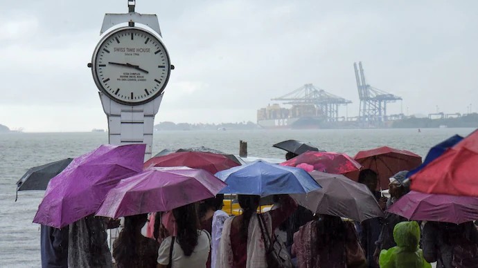
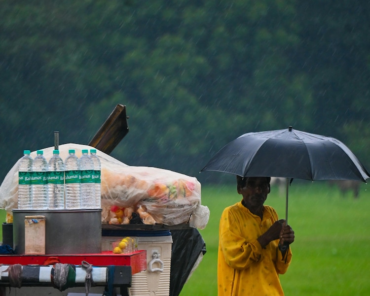
The monsoon season is one of the most eagerly awaited times of the year. The monsoon shows up like a guest you’ve been waiting for a long time. The air changes, the sky turns gray, and then the first drops start falling. It feels like the whole world is taking a deep breath after the heat a moment to slow down and soften.
People lean out of their balconies just to watch the rain pour. Kids splash around in puddles, not caring much about umbrellas that never seem to keep them dry. Children run into puddles, ignoring umbrellas that never quite do their job. Streets slow down, traffic jams get longer, clothes refuse to dry yet nobody really complains, because the rain brings its own kind of joy.
There’s something beautiful even in all the mess the rain brings. The sound of raindrops hitting the windows becomes a kind of music for those late-night talks. Taking long walks with an umbrella turns into moments you remember later. Even small things, like sipping hot chai by the window, feel special and poetic during the monsoon.
The monsoon is messy, inconvenient, and unpredictable, but it’s also comforting. After the heat, it feels like nature has pressed reset.
Monsoon in India has a permanent place in Indian culture in songs, poetry, films, and traditional art. From classical music ragas to Bollywood melodies, from folk tales to festivals, rain has been celebrated for generations. That timing is everything. The monsoon is not a single event. It is a four-month system, and its final month, September, is when standing crops are at their most vulnerable. During the grain-filling stage, when paddy and other kharif crops convert accumulated nutrients into actual grain, sustained rainfall is not optional. An El Nino that arrives weak and intensifies as the season progresses, peaking just as September begins, is the worst possible sequence for Indian agriculture. India is not alone in sounding the alarm. Australia’s Bureau of Meteorology has projected that El Nino conditions could emerge as early as June. China’s National Climate Centre has reported that Pacific warming has already entered an El Nino phase and is expected to strengthen in the months ahead.
Nasa, analysing data from the Sentinel-6 Michael Freilich satellite, which maps the height of the entire ocean surface every ten days, has detected a large mass of warm water building beneath the Pacific, precisely the kind of subsurface heat reservoir that scientists recognise as a reliable precursor to El Nino formation.
NO SAFETY NET FROM THE INDIAN OCEAN
In some El Nino years, India has been shielded by a phenomenon called the Indian Ocean Dipole, or IOD.
Picture it as a temperature see-saw sitting across the Indian Ocean: when the western end runs warmer than the eastern end, a positive IOD develops, driving additional moisture toward the subcontinent and partially neutralising El Nino’s drying effect.
This is precisely what saved India’s 1997-98 monsoon, when a strongly positive IOD counteracted one of the strongest El Nino events on record and delivered near-normal rainfall to the country regardless.
This year, IMD’s models show IOD conditions are neutral and are expected to remain so through the entire monsoon season. There is no safety net. Whatever El Nino does to the Pacific, the Indian Ocean will not push back.
WHO GETS HIT HARDEST?
IMD’s regional breakdown offers little comfort. The northeast is the only broad zone expected to see near-normal rainfall, between 94 and 106 per cent of the long-period average.
Central India, south peninsular India, and northwest India are all forecast to receive below-normal rains. The northwest could receive as little as 92 per cent of normal.
The sharpest concern is what IMD calls the Monsoon Core Zone: a wide band of states stretching from Gujarat in the west to Odisha in the east, covering the bulk of the country’s rainfed farmland.
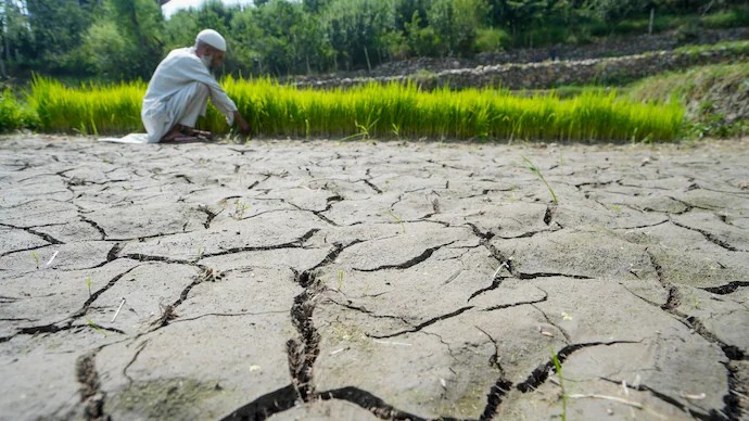
This entire zone is forecast to receive below-normal rainfall. Around 60 per cent of India’s farmers work without any irrigation backup. For them, there is no borewell to fall back on, no canal network to draw from. What the sky delivers between June and September is the entire agricultural year. A monsoon deficit across the Core Zone means lower yields of kharif crops: rice, pulses, oilseeds, and coarse cereals sown at the start of summer and harvested in autumn.
Food makes up roughly 37 per cent of India’s inflation basket. When harvests shrink, grocery prices climb, and the burden lands the hardest on the households least able to absorb it.
IS THERE ANY REASON FOR HOPE?
El Nino is not a guarantee of drought. Five of the 17 El Nino events recorded between 1951 and 2022 brought normal or above-average rainfall to India despite the Pacific warming.
Monsoon systems are driven by many variables simultaneously, and IMD will continue issuing updated regional forecasts as the season unfolds.
The next bulletin, covering July rainfall, is expected in the last week of June 2026.
But the numbers standing today are hard to look past. A 60 per cent chance of a deficient monsoon. A historical baseline of 16 per cent. An El Nino still building in strength. An Indian Ocean with nothing to offer in return. And a forecast that has already been revised downward once since April.
The rains may still come. But for the first time in over a decade, the question is no longer whether India’s monsoon will be good. It is how bad it will get.
Kerala misses early date with monsoon: When will rain and cool winds arrive? India’s most awaited season was expected early this year, but shifting skies and weather conditions have changed the timeline. Here’s when monsoon rains are now expected to arrive.
The monsoon this year was expected to arrive in Kerala on May 26, the Indian Meteorological Department (IMD) had said in its forecast. The date was optimistic as it was five days ahead of the normal June 1 date.
But that hasn’t happened. Monsoon arrival pushed back again: When will rains finally reach India?
The season that millions have been waiting for is once again facing an unexpected hurdle, extending the wait for relief from one of India’s hottest years.
India’s southwest monsoon, which was supposed to have arrived in Kerala by now, is running behind schedule, and the latest forecast suggests it won’t make landfall before June 3, with some weather experts now saying it could slip even further. India’s southwest monsoon, which was supposed to have arrived in Kerala by now, is running behind schedule, and the latest forecast suggests it won’t make landfall before June 3, with some weather experts now saying it could slip even further. Rains delayed: Why has Kerala missed its early date with monsoon?
India was expecting an early monsoon this year, but something around the Bay of Bengal has unexpectedly changed the timeline. Read when the rains will now arrive.

India’s southwest monsoon, which was forecast to arrive ahead of schedule, on May 26, has been delayed.
The reason?
Kerala
Praised with the epithet ‘God’s Own Country’, Kerala is strategically located at the southwestern tip of India and enjoys unique geographical features. The state is surrounded by the Arabian Sea in the west and is flanked by the towering Western Ghats in the east with a network of 44 interconnected rivers.
Palm-fringed backwaters, beaches, hill stations, tropical forests, waterfalls and wildlife makes Kerala one of the sought-after tourist destinations in the country. Located on the Malabar coast of India, Kerala was formed on November 1, 1956, after Malayalam speaking regions were integrated with Malabar, Cochin and Travancore regions. Often labelled as the ‘Spice Coast of India’, Kerala hosted several travellers and traders from across the world such as Portuguese, Romans, Greeks, Dutch and French.
Trivandrum is the capital city of Kerala and Malayalam is its official language. Kerala is the twenty-first largest state in India with hundred per cent literacy and also boasts of its organised urbanisation with a relatively high media exposure. The state was adjudged the best performer in the NITI Aayog’s Sustainable Development Goals (SDG) index for the year 2020-21.
While agriculture is the main occupation of the people, more than one million people in Kerala depend on fishing. Kerala is considered one of the most progressive states in the country in terms of education, social welfare and quality.
Kochi, Kollam, Thrissur, Kozhikode, Kannur, Alappuzha, Munnar and Kottayam are some of the major cities in Kerala. The Silent Valley in the Palakkad district is one of the well-known biodiversity hotspots in the world. Padmanabhaswamy Temple, tea gardens, Poovar island, Alleppey backwaters, Kappad beach, Parambikulam Tiger Reserve and Nelliyampathy hills are some of the recommended tourist destinations in the state.
Monsoon advances after missing early date: When will rain hit north India? India’s long-awaited monsoon may have stumbled, but it hasn’t stopped. The rain-bearing system is now gathering strength over surrounding seas and is back on track.

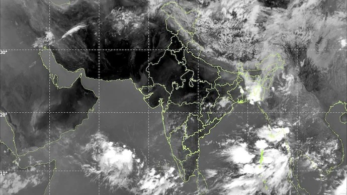
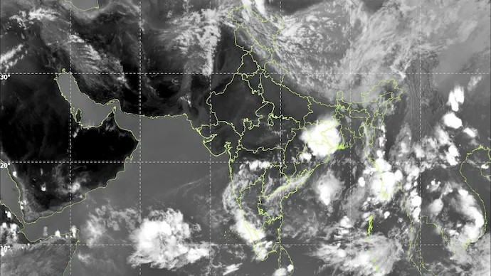
India’s southwest monsoon is continuing its gradual advance over the surrounding seas of southern India, despite missing its anticipated early onset over Kerala this year. According to the India Meteorological Department has further progressed into parts of the Arabian Sea, Lakshadweep region, Bay of Bengal and the Andaman Sea, indicating that the seasonal rain-bearing system is steadily gathering steam after a brief slowdown.

Western disturbance to begin rolling in, monsoon to advance further today fresh Western Disturbance is set to bring thundersqualls, hail and dust storms across parts of North and central India. The change comes as the southwest monsoon advances further and temperatures in the northwest are forecast to ease.
Wednesday was another tale of two weather systems pulling in opposite directions.
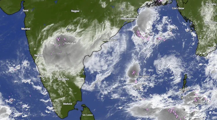
The south saw plenty of action, with Andaman & Nicobar Islands being drenched at most stations, while Telangana, Rayalaseema, coastal parts of Andhra Pradesh, Karnataka, and Lakshadweep all receiving significant rainfall.
Bhoothpur in Telangana’s Mahabubnagar district recorded the highest single-station rainfall of the day at 11 cm. Heavy rain was also observed in parts of Andhra Pradesh, Telangana, Rayalaseema, Tamil Nadu and Karnataka, and hailstorms struck isolated spots in Marathwada and Uttarakhand. Up north and across central India, the story was very different.
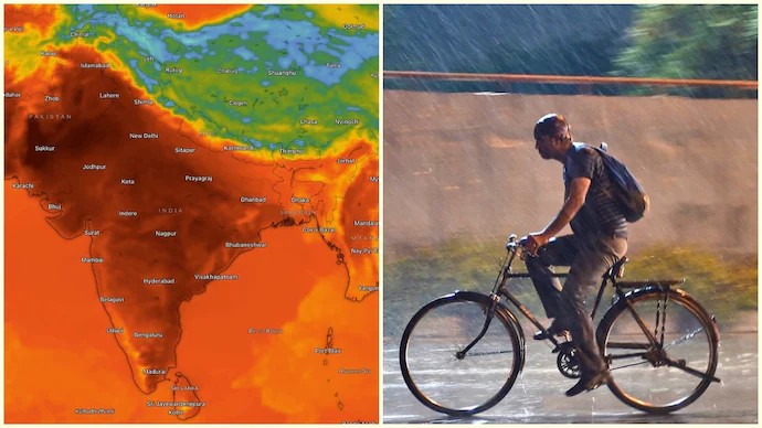
Heat wave to severe heat wave conditions continued to grip East Uttar Pradesh, with heat wave conditions also prevailing across Haryana, West Uttar Pradesh, West and East Madhya Pradesh, Vidarbha, and Chhattisgarh.
In light of the lingering heat, Prime Minister Narendra Modi issued an advisory, urging citizens to prioritise safety as temperatures soar. He emphasized staying hydrated, carrying water bottles, and offering water to others in need. PM Modi advised monitoring signs of heat exhaustion such as dizziness and fatigue, while encouraging people to regularly check on elderly family members. He also appealed for compassion towards wildlife, asking citizens to place water bowls for birds and animals.
STORMS TO STRIKE TODAY
Thursday is set to shift the tone for North India. Today is the day north and central India have been waiting for. Rain on horizon, heat to reduce: Here’s when temperatures will dip in Delhi-NCR
Delhi-NCR is likely to see thunderstorms, dust storms and widespread rain. The shift may bring relief from intense heat but could also cause disruption through strong winds and lightning.
After days of punishing heat across Delhi-NCR, relief may finally be on the horizon.
Weather conditions are expected to shift dramatically from Thursday evening onward, with forecasts pointing to thunderstorms, dust storms and widespread rainfall activity that could pull daytime temperatures below 40 degrees Celsius over the weekend.
Meteorologists say residents will have to endure intense heat for a little longer, at least until Thursday afternoon, before a fresh spell of unstable weather begins developing across north and central India.
The approaching system is expected to trigger strong dust storms accompanied by moderate to heavy thundershowers, bringing a sharp dip in temperatures across the region.
The change could offer much-needed respite to Delhi-NCR, where scorching daytime temperatures and warm nights have kept heat stress levels elevated. Forecast models indicate that once storm activity begins, temperatures are likely to fall significantly from the current highs, with cloud cover, rain and gusty winds helping cool the atmosphere.
However, weather experts have also warned that the incoming relief may come with dangerous conditions. Authorities and residents have been advised to remain cautious, especially during evening hours when storm activity is expected to peak. Strong winds during dust storms can uproot trees, disrupt traffic movement and damage temporary structures, while intense lightning and heavy rainfall may create hazardous conditions in several parts of the National Capital Region.
The expected weather shift is part of a broader summer storm outbreak forecast across northern and central India. For Delhi residents, the forecast brings a mixed picture: relief from relentless heat, but also the possibility of turbulent weather through the weekend. Experts say the coming days may see rapidly changing conditions, with sunny and hot afternoons quickly turning into stormy evenings. The cooling trend is expected to continue through the weekend if rainfall activity remains widespread. Weather watchers say this could temporarily suppress heatwave conditions in parts of northwest India, although humidity levels may rise after rainfall.
For now, Delhi-NCR waits for the skies to finally break after another blistering stretch of summer heat.
As a result, forecast for Punjab, Haryana, Chandigarh & Delhi, and West Uttar Pradesh, include thundersqualls with speeds of 60–70 kmph gusting up to 80 kmph.
East Uttar Pradesh faces similarly dangerous squalls, while isolated hailstorms are expected across Uttar Pradesh, Gangetic West Bengal, Haryana, Delhi, Himachal Pradesh, Punjab, and Uttarakhand.
Powerful thundersqualls of 50–60 kmph are also likely over Andhra Pradesh, East Uttar Pradesh, Jammu & Kashmir, Jharkhand, Odisha, Rajasthan, and Uttarakhand.
Furthermore, dust storms are forecast for Rajasthan and Uttar Pradesh, and heavy rainfall is expected at isolated spots in Assam & Meghalaya, Bihar, Nagaland, Manipur, Mizoram & Tripura, and Tamil Nadu & Puducherry.
Despite all this storm activity, heat wave conditions will still be present in several regions, including Chhattisgarh, East Rajasthan, Haryana, Delhi, Himachal Pradesh, Goa, Odisha, Punjab, Telangana, Uttar Pradesh, and West Madhya Pradesh, with severe heat wave conditions very likely in East Madhya Pradesh, Vidarbha, and West Rajasthan.
MONSOON DELAYED BUT NOT TOO FAR AWAY
There is genuinely good news on the horizon, too.
India’s life-giving seasonal rain system, called southwest monsoon, made further headway on Wednesday, advancing into parts of the southwest and southeast Arabian Sea, Lakshadweep, the Bay of Bengal, and the remaining parts of the Andaman Sea.
Conditions are expected to remain favourable for it to push further north over the next two to three days.
More immediately, temperatures across Northwest India are forecast to fall by 6-8°C between May 28 and May 30, which would mark a much-needed drop after weeks of punishing heat.
For millions baking across Uttar Pradesh, Delhi, Punjab, and Haryana, the worst may finally be almost over. Monsoon is late, but as the adage goes, better late than never.
Weather
There’s a strange kind of beauty in all the mess that comes with the different weather seasons. The sound of water hitting the windows late at night somehow makes everything feel calmer. Walks with an umbrella, even when your feet get soaked, end up staying in your memory. And then there are those quiet moments just sitting by the window, hands wrapped around a warm cup of chai, watching the rain fall. Nothing fancy, but it feels almost poetic in its own way.
Weather, in general, has a way of setting the tone for our lives, even when we don’t realize it. A bright, sunny morning can push us into motion. A cloudy afternoon might slow us down. Rain doesn’t just water the ground it stirs something inside. It can make a regular day feel heavy or peaceful, depending on what’s going on in your mind. It brings people indoors, but also somehow closer. The weather shapes moods, plans, and sometimes even conversations.
It changes how the day feels. It makes you notice things like the smell of the soil, the sound of birds that only sing in the rain, or how trees look greener than usual.
Weather is one of those things we talk about every single day without even noticing. It’s the first thing people mention in small talk, and yet it shapes so much of how we live. A sunny morning can make you feel unstoppable, while a grey, cloudy sky can slow everything down before the day even begins.
Sometimes it feels like weather carries moods of its own. Summer heat that sticks to your skin, making you crave shade and cold water. The chill of winter mornings when getting out of bed feels like the hardest task in the world. The gentle breeze on a spring evening that makes you want to walk a little slower. What that means is that the weather system is gradually organising itself over the Indian Ocean region after the recent delay.
However, the onset did not take place as expected due to temporary weakening in monsoon winds and lack of sustained rainfall activity near the Kerala coast.
- Bay of Bengal Cyclone: Recent cyclonic activity in the Bay of Bengal disrupted the normal streamlined flow of the monsoon sub-systems.
- El Niño Influence: An unusually calm Indian Ocean coupled with a transitioning, developing El Niño in the Pacific Ocean has limited cloud formation and weakened wind patterns.
Forecast and Agricultural Impact
- Weak Initial Phase: The IMD projects that the upper-level winds will only fully establish after June 5–6. Consequently, the initial spell of the monsoon along the Kerala coast is expected to build up very gradually.
- Rainfall Deficit: In its revised seasonal long-range forecast, the IMD indicated that India is expected to receive below-normal rainfall at 90% of the Long Period Average (LPA) this year, raising concerns about drought conditions and reservoir levels.
- Current scattered pre-monsoon thunderstorms do not provide the sustained soil moisture required for crops like paddy and soybean.
Immediate Weather Alerts
Even though the formal declaration is pending, an upper-air cyclonic circulation off the south Kerala coast is triggering heavy weather. The IMD has issued heavy rain alerts for isolated areas in Kerala, predicting downpours ranging from 7 cm to 20 cm over the next week alongside fishing bans and coastal wind advisories.