List of 5 Largest Caves in the World
Biggest Caves in the World: Sơn Đoòng Cave in Vietnam holds the title of the largest cave in the world. Discovered in 1991 and thoroughly explored in 2009, it stretches over 5 kilometres in length and reaches heights of 200 meters. The cave is so vast that it contains its own river, jungle, and even clouds. Hidden within Phong Nha-Kẻ Bàng National Park, Sơn Đoòng is a breathtaking underground world that continues to amaze scientists and adventurers alike.

Caves are one of nature’s most fascinating creations. Found all over the world, there are thousands of known caves—each with its own story. Some caves are millions of years old, having been formed by water slowly eroding through rock over a prolonged period of time. Others were shaped by volcanic activity or tectonic shifts. These underground wonders come in all sizes, ranging from small chambers to massive networks that stretch for miles.
But do you know which is the largest cave in the world? It’s Sơn Đoòng Cave in Vietnam. This cave is so big that it has its own river, jungle, and weather system. Its main chamber is over 5 kilometres long and 200 meters high—tall enough to fit a skyscraper inside.
In this article, we’ll take a look at the largest caves on Earth. From hidden gems to record-breaking giants, each one offers a glimpse into the mysterious world beneath our feet.
According to the latest data, here’s the list of the largest caves in the world:
| Rank | Cave Name | Location | Primary Measurement | Notable Features |
| 1 | Hang Sơn Đoòng | Vietnam | Volume: 38.5 million m³ | Largest by volume: underground jungle, river |
| 2 | Miao Room (Gebihe) | China | Volume: 10.8 million m³ | Largest single cave chamber by volume |
| 3 | Sarawak Chamber | Malaysia | Volume: 9.7 million m³ | Largest by surface area; colossal single chamber |
| 4 | Mammoth Cave | USA | Length: ~685.6 km | Longest cave system in the world |
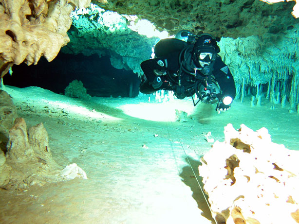
| 5 | Sistema Ox Bel Ha | Mexico | Length: ~524.1 km | Longest underwater cave system |
| 6 | Shuanghedong Cave | China | Length: ~437.4 km | The largest cave system in Asia |
| 7 | Sistema Sac Actun | Mexico | Length: ~391 km | Large underwater network, major archaeological finds |
| 8 | Jewel Cave | USA | Length: ~346 km | Densely packed crystals, extensive chambers |
| 9 | Optymistychna Cave | Ukraine | Length: ~263 km | Longest gypsum cave in the world |
| 10 | Clearwater System | Malaysia | Length: ~236 km | Noted for large passages and biodiversity |
List of 5 Largest Caves in the World
Sep 29, 2025, 13:05 IST
Biggest Caves in the World: Sơn Đoòng Cave in Vietnam holds the title of the largest cave in the world. Discovered in 1991 and thoroughly explored in 2009, it stretches over 5 kilometres in length and reaches heights of 200 meters. The cave is so vast that it contains its own river, jungle, and even clouds. Hidden within Phong Nha-Kẻ Bàng National Park, Sơn Đoòng is a breathtaking underground world that continues to amaze scientists and adventurers alike.
Caves are one of nature’s most fascinating creations. Found all over the world, there are thousands of known caves—each with its own story. Some caves are millions of years old, having been formed by water slowly eroding through rock over a prolonged period of time. Others were shaped by volcanic activity or tectonic shifts. These underground wonders come in all sizes, ranging from small chambers to massive networks that stretch for miles.
But do you know which is the largest cave in the world? It’s Sơn Đoòng Cave in Vietnam. This cave is so big that it has its own river, jungle, and weather system. Its main chamber is over 5 kilometres long and 200 meters high—tall enough to fit a skyscraper inside.
In this article, we’ll take a look at the largest caves on Earth. From hidden gems to record-breaking giants, each one offers a glimpse into the mysterious world beneath our feet.
According to the latest data, here’s the list of the largest caves in the world:
1. Hang Sơn Đoòng (Vietnam)
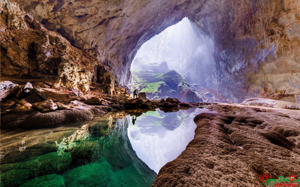
Hang Sơn Đoòng is the largest cave in the world by volume, located in Phong Nha-Kẻ Bàng National Park, Vietnam. Discovered in 1990 and surveyed in 2009, it boasts a colossal interior measuring over 9 kilometres in length, with chambers reaching up to 200 meters in height and 150 meters in width. Its estimated volume of 38.5 million cubic meters makes it large enough to house entire city blocks and towering skyscrapers. The cave’s spectacular features include an underground river, two natural skylights that allow forests to thrive within, enormous stalagmites reaching heights of up to 80 meters, and rare calcite formations.
2. Miao Room (Gebihe Cave System, China)

The Miao Room is recognised as the largest single cave chamber by volume, located in China’s Gebihe Cave System in Guizhou Province. First discovered in 1989, this immense chamber measures 852 metres in length and 191 metres in width, with an area of 154,500 square metres and a volume of 10.8 million cubic metres. The sheer size of the Miao Room is staggering—it can comfortably accommodate several football stadiums side by side. Its geological formations include giant stalactites and stalagmites.
The Miao Room is the world’s largest known cave chamber by volume, located within the Gebihe cave system in Ziyun Getu He National Park, China. Discovered by a French expedition in 1989, the Miao Room has a staggering volume of 10,780,000 cubic meters. It measures 852 meters in length and 191 meters in width, covering an area of 154,500 square meters.
Based on volume, the largest single cave chamber is the Miao Room – part of the Gebihe cave system in Ziyun Getu He National Park in Guizhou Province, China. The chamber was mapped with 3D laser scanners by a British-led geology team, funded by National Geographic, in 2013 and was subsequently calculated to have a volume of 10.78 million cubic metres (380.7 million cubic feet). The measurements were announced at the Hidden Earth 2014 national caving conference, held in the UK from 26–28 September 2014.
The Miao Room cavern was first documented by a Chinese-European geology team in 1989.
The previous record holder, the Sarawak Chamber in Gunung Mulu National Park, Sarawak in Malaysian Borneo, is about 10% smaller in volume than the Miao Room, however it retains the title of largest single cave chamber by area, with an approximate surface area of 154,530 square metres (1.66 million square feet) versus 140,540 square metres (1.51 million square feet) for the Miao Room.
The Miao Room also features some of the tallest stalagmites in the world, standing up to 45 metres (148 feet) tall.
Key Facts:
- Location:Ziyun Getu He National Park, Guizhou Province, China.
Miao Room is the largest known cave chamber by volume in the world.[1] It is a part of the Gebihe cave system, which is located in Ziyun Getu He National Park in Ziyun Miao and Buyei Autonomous County is a county in the southwest of Guizhou province, China. It is under the administration of the prefecture-level city of Anshun.The Chinese province of Guizhou[a] is an inland province in Southwestern China. Its capital and largest city is Guiyang, in the center of the province. Guizhou borders the autonomous region of Guangxi to the south, Yunnan to the west, Sichuan to the northwest, the municipality of Chongqing to the north, and Hunan to the east. Guizhou has a humid subtropical climate. It covers a total area of 176,200 square kilometers and consists of six prefecture-level cities and three autonomous prefectures. The population of Guizhou stands at 38.5 million, ranking 18th among the provinces in China.
The Dian Kingdom, which inhabited the present-day area of Guizhou, was annexed by the Han dynasty in 106 BC.[6] Guizhou was formally made a province in 1413 during the Ming dynasty. After the overthrow of the Qing in 1911 and following the Chinese Civil War, the Chinese Communist Party took refuge in Guizhou during the Long March between 1934 and 1935.[7] After the establishment of the People’s Republic of China, Mao Zedong promoted the relocation of heavy industry into inland provinces such as Guizhou, to better protect them from potential foreign attacks.[citation needed]
Located in the hinterland of the southwestern inland region, Guizhou is a transportation hub in the southwest area and an important part of the Yangtze River Economic Belt.[8] It is the country’s first national-level comprehensive pilot zone for big data,[9] a mountain tourism destination and a major mountain tourism province,[10] a national ecological civilization pilot zone,[11] and an inland open economic pilot zone.[12]
The representative historical culture is “Qian Gui culture”(黔贵文化).[13] In addition, Guizhou is also one of the birthplaces of ancient Chinese humans and ancient Chinese culture, with ancient humans living on this land since about half a million years ago.[14]
Guizhou is rich in natural, cultural and environmental resources. Its natural industry includes timber and forestry, and the energy and mining industries constitute an important part of its economy. Notwithstanding, Guizhou is considered a relatively undeveloped province, with the fourth-lowest GDP per capita in China as of 2020. However, it is also one of China’s fastest-growing economies.[15] The Chinese government is looking to develop Guizhou as a data hub.[16][17]
Guizhou is a mountainous province, with its higher altitudes in the west and centre. It lies at the eastern end of the Yungui Plateau. Demographically, it is one of China’s most diverse provinces. Minority groups account for more than 37% of the population, including sizable populations of the Miao, Bouyei, Dong, Tujia and Yi peoples, all of whom speak languages distinct from Chinese. The main language spoken in Guizhou is Southwestern Mandarin, a variety of Mandarin.
The five largest cave systems in the world by length are the Mammoth Cave (USA) at 685.6 km, Sistema Ox Bel Ha (Mexico) at 524.1 km, Shuanghedong Cave Network (China) at 437.4 km, Sistema Sac Actun (Mexico) at 387.1 km, and Jewel Cave (USA) at 354.59 km. These vast subterranean networks are measured by the length of their explored passageways.
Mammoth Cave is the world’s longest known cave system, located in south-central Kentucky within Mammoth Cave National Park. Formed by water dissolving Mississippian-aged carbonate rocks, it features over 405 miles of mapped passages and is a UNESCO World Heritage Site. The park is known for its diverse wildlife, plant species, and historical significance, including artifacts from early Indigenous peoples.
Mammoth Cave in Kentucky is the world’s longest known cave system, with more than 400 miles explored, and one of the oldest tour attractions in North America.
Mammoth Cave National Park preserves the cave system, a part of the Green River Valley, and the rolling hills of south central Kentucky. While cave tours of the 10 miles available in the cave are the park’s big attraction, there is plenty more to do and explore while visiting this beautiful wilderness area, such as hiking, camping, horseback riding, fishing and kayaking.
Mammoth Cave National Park is known for housing the world’s longest cave system, with over 405 miles (651 km) mapped. The vast cavern system was formed by water slowly dissolving Mississippian-aged carbonate rocks, creating sinkholes, tunnels, and underground rivers. This national park is also host to a diverse group of animal and plant species due to the microclimates created by varying light and temperature conditions.
Geologic History
Mammoth Cave National Park has one the most famous karst topographies in the entire world. Karst terrain is created by dissolution of soluble rocks like limestone or dolomite and is characterized by the presence of cave systems, sinkholes, springs, and disappearing streams (surface water that suddenly flows underground). The park is located within the Central Kentucky Karst, a limestone belt that extends from southern Indiana through Kentucky into Tennessee. It is part of the Chester Upland and the Pennyroyal Plateau and is dissected by the Green River, which controls the cave development. The sedimentary rocks that form the park were produced from sediments that were deposited when this area was submerged by an ancient ocean 330 million years ago as great inland seas or as near-shore deposits. The erosional force of the Green River has helped to carve the limestone into the unique and extraordinary karst topography of this region over millions of years.
Stratigraphy
Stratigraphy is the study of rock layers and their relationship to one another, helping researchers understand how the environment has changed over time. Rock layers are split into large sediment packages called formations, grouped based on common characteristics. Formations are sometimes split into smaller members, narrowed down to a more specific group of characteristics.
The four rock formations, from oldest to youngest, found in Mammoth Cave are the St. Louis Limestone, the Ste. Genevieve Formation, the Girkin Formation, and the Big Clifty Formation. The largest caves are formed in the first three limestone units, while the Big Clifty, predominately shale and sandstone, forms a caprock of more chemically resistant rock.
The St. Louis Limestone is the oldest unit exposed, the first unit deposited that we can still see from the surface and cave exposures. This unit was deposited during the Mississippian about 330 million years ago and is composed of fine to medium-grained limestone, dolomite, sandstone, siltstone, and greenish-gray shale. These sediments are typically found in marine environments. The fossilized remains of corals, bryozoans, brachiopods, shark teeth, gastropods, and crinoids have been found in this area and support that this part of what is now Kentucky was an ancient sea. Other important characteristics of this formation are horizontal beds and flat nodules of chert (a specific type of hard, very fine-grained sedimentary rock composed of silica) that protrude from the cave walls because they weather more slowly than the rest of the limestone and gypsum (a soft, hydrated calcium sulfate mineral).
The Ste. Genevieve Formation overlies the St. Louis Limestone and consists of interbedded limestone and dolomite, no gypsum is found in this unit. The Ste. Genevieve Formation contains similar fossils as in the St. Louis Formation.
The Girkin Formation lies above the Ste. Genevieve Formation and is predominantly made up of fine-to coarse-grained crystalline limestone. When these rocks were deposited, the area was still under water. An interesting feature found in this formation is the presence of oolites (small concentric spheres of calcium carbonate that form in shallow marine waters). This formation is separated by local interbedding of shale and sandstone, forming a lower oolitic portion and an upper fossiliferous portion. This upper fossiliferous section include the remains of many marine organisms such as corals, brachiopods, crinoids, and echinoids.
Mammoth Cave is the world’s longest known cave system, located in south-central Kentucky within Mammoth Cave National Park. Formed by water dissolving Mississippian-aged carbonate rocks, it features over 405 miles of mapped passages and is a UNESCO World Heritage Site. The park is known for its diverse wildlife, plant species, and historical significance, including artifacts from early Indigenous peoples.
Key Characteristics:
- World’s Longest Cave System:With over 405 miles of explored passages, it is the longest known cave system globally.
- Formation:The cave system was formed over time by water slowly dissolving carbonate rocks, creating numerous tunnels, sinkholes, and underground rivers.
- Location:It is situated in south-central Kentucky.
- Protected Area:The cave is part of Mammoth Cave National Park, which is a UNESCO World Heritage Site.
- Ecological Diversity:The park is home to a wide variety of plant and animal species.
- Historical Importance:Early Indigenous peoples have been discovered within the caves, highlighting a long history of human interaction with the site.
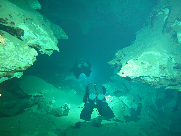
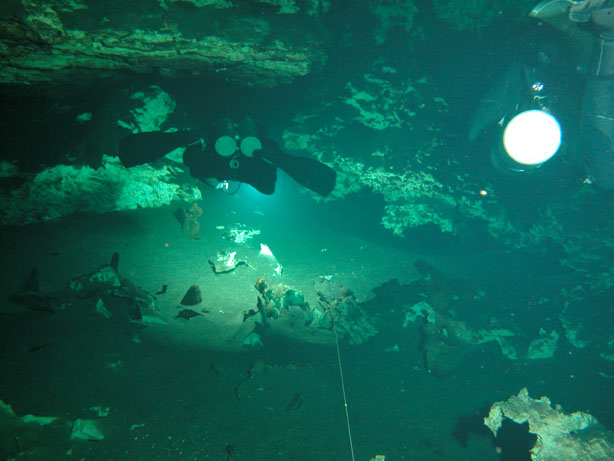
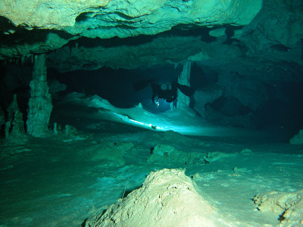
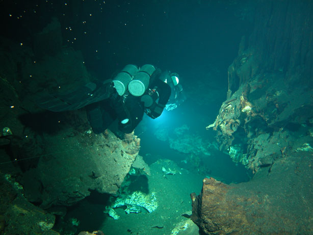
Ox Bel Ha: The Charismatic Mexican Giant
Quintana Roo, one of three states forming Mexico’s Yucatan Peninsula, is renown for its spectacular white sand beaches, turquoise water and Mayan ruins, quite an accomplishment for a land that not long ago was still regarded as an inaccessible, primitive and forgotten territory inhabited by outlaw chicleros.
In the past twenty years, another world, equally spectacular, lying beneath the jungle floor, has begun to come to light. Marked by giant caverns, complex subterranean passageways, and intricate decorations, this intricate world was carved out of a thick layer of limestone by a filtering solution of rainwater and carbon dioxide (carbonic acid). Severe climatic changes 18,000 years ago led to a change in ocean level; the significant rise in water levels that ensued flooded and sealed this underground landscape.
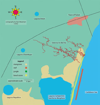 Today, Quintana Roo has eighty-two explored and surveyed underwater cave systems. Most of these are concentrated in a tight perimeter around localities such as Tulum, Akumal and Puerto Aventuras. In fact, four of the largest, Ox Bel Ha, Nohoch Nah Chich, Dos Ojos and Najanral, lie within a 30-mile radius.
The general layouts of area cave systems are quite similar; conduits run northwest (upstream) to southeast (downstream), conducting water through numerous bedding fractures to the Caribbean Sea. Individually, however, these cave systems, despite their similarities, are worlds of their own, marked by distinctive geologic formations and hydrologic particularities.
Nonetheless, one underwater cave system here stands out in the manner in which it brings together many of the diverse elements and characteristics that distinguish other area cave systems. This is Ox Bel Ha, Mayan for “Three Paths of Water.” Nested south of the Mayan town of Tulum, and north of the Sian’ Kaan Biosphere, Ox Bel Ha lies beneath an enormous stretch of land that belongs in part to Ejido Pino Suarez and in part to Ejido Tulum. There are several reasons why exploration of this cave system did not begin until the spring of 1998. From where it is most easily accessible, a side road, the cave is marked by a group of small, complex and unattractive tunnels. This alone was enough to turn away the less determined cave diver, especially since there were a number of highly decorated cave systems under active exploration at the time. In comparison to these other systems, Ox Bel Ha seemed to be a bleak prospect. Potentially more promising cenotes that would grant entrance into the cave system were situated much further inland, and access to these is both extremely difficult and logistically challenging. Despite these reasons, exploration finally began.
D. Riordan
Ox Bel Ha is a classic example of a coastal cave. Its main feature is a higher fresh water layer flowing on top of a near-static salt-water layer, one that intrudes from the nearby Caribbean Sea. This creates a halocline, or a mixing zone, between unequal water densities. The halocline can be found at different depths; depths gradually increase as the distance to the ocean increases. For this reason, fresh water layers will be thicker inland where the salt water is less intrusive. In Ox Bel Ha, the halocline can be found anywhere between 25 feet and 50 feet deep.
A change in water level due to daily tidal change is visually apparent in the numerous cenotes. In reality, however, only a few of the area cave systems connect directly with the Caribbean Sea. Many empty into mangrove beds and wetland “savannah,” others in calettas (small bays), and still others eventually reach the ocean, but only through a myriad of small voids in the limestone bedrock.
D. Riordan
Ox Bel Ha’s downstream runs under marshy land, but continues its course below the beach line where part of the aquifer empties onto the coral reef via three distinct vents. In Ox Bel Ha, the low flow that commonly characterizes the caves in this side of the Yucatan intensifies enormously as the fresh water nears its oceanic destination.
During the rainy season, there is a noticeable increase in outflow. For the rest of the year, it seems that, even during long dry spells, water flow intensity remains constant. Fresh water exits with so much force at Ox Bel Ha that salt-water intrusion never gets deeper than 10 feet. At 10 feet, salt and fresh water mix in the most disorganized fashion until they reach the surface of the ocean. Infrequently, an influx of salt water will occur, generating poor water visibility from the disturbed sand particles. This is generally caused by changes in tide or severe weather conditions, and was recently observed during the fallout from Hurricane Isidore.

D. Riordan
D. Riordan
The 96.5 kilometers (60.3 miles) of explored and surveyed passages in Ox Bel Ha represent the greatest variety of cave in the area. This is hardly surprising considering that Ox Bel Ha lies under a terrain that plays host to a multiplicity of diverse ecosystems. Both above the ground and underground, this domain boasts an exciting collection of natural phenomena, ranging from 550 species of bird, 182 species of reptile and amphibian (of which 14% are endemic), 103 species of mammal, 800 plant species, 112 species of orchid and, finally, 38 stygobitic species (of which 36 are crustacean and two are fish).
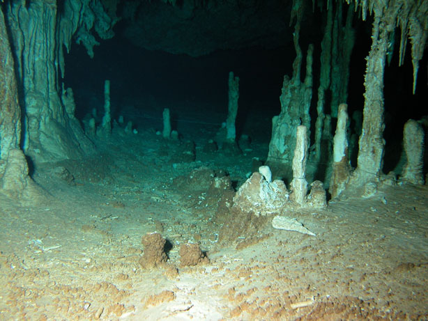
Ox Bel Ha extends beneath several pristine environments such as the Mesoamerican Barrier Reef, mangroves and salt marshes, saw grass and jungle. As it makes its way inland beneath these distinct terrains, its features change. Speleothems become more abundant; passages become increasingly whiter, larger and more defined. There are fifty-six cenotes that are connected to this cave system. The distant Laguna Campechen, Napalitos, Chumkopo and Union are key elements that, more than likely, influence the general disposition of the cave.
Prior to exploration, no one could have imagined the potential of this system and how it fit, like a piece of a gigantic jigsaw puzzle, into the mysterious topography of the Mayan underworld. The future exploration of Ox Bel Ha will give us further insight into the area’s complexities, providing invaluable information for our generation and future generations alike.
D. Riordan