IMD weather update: Heavy rainfall forecast for South India; Monsoon withdrawal in north-western states

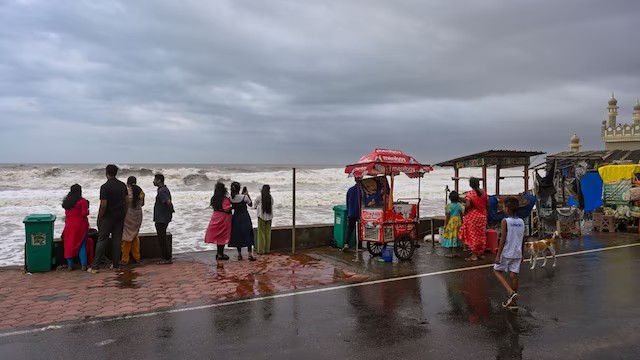
South Indian states are bracing for heavy rainfall from October 8-12 due to Cyclone Shakti’s remnants, with alerts issued for thunderstorms and gusty winds. Meanwhile, the southwest monsoon is retreating from Gujarat, Madhya Pradesh, and Uttar Pradesh, bringing pleasant weather but also warnings of isolated thunderstorms.
A series of weather advisories as the southwest monsoon begins to retreat from parts of India, while southern states brace for heavy rainfall due to the remnants of Cyclone Shakti.
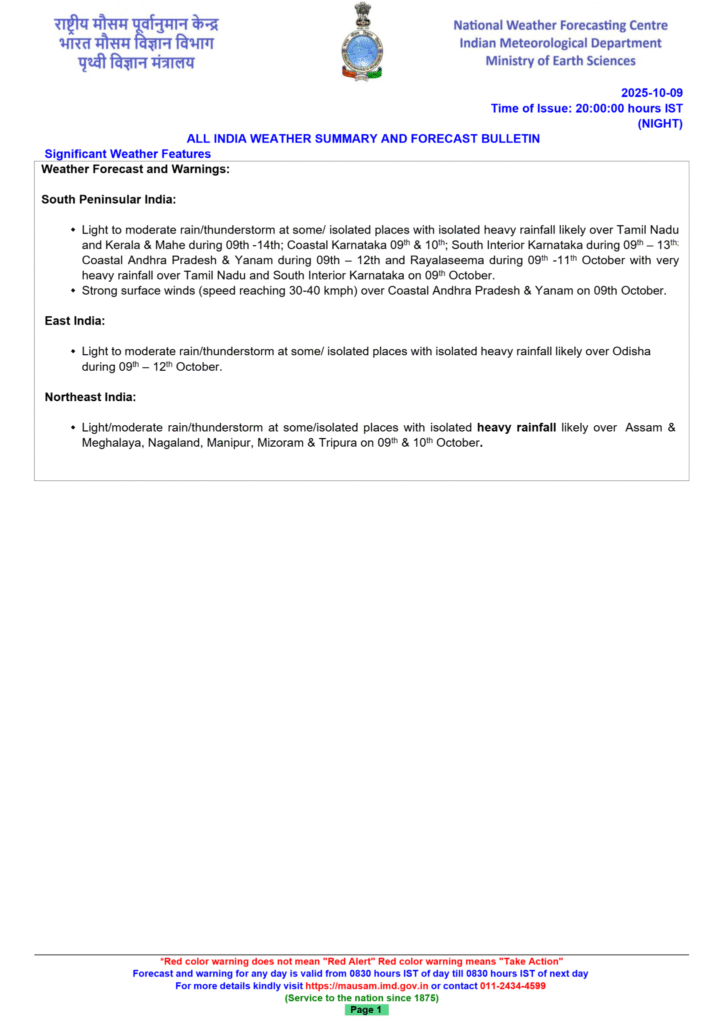
An India Meteorological Department (IMD) update from October 9, 2025, forecasts heavy rainfall across southern and eastern India, while the southwest monsoon continues its withdrawal from the northwestern and central states. The contrasting weather is influenced by the weakening of Cyclone Shakhti’s remnants and other weather systems.
The India Meteorological Department (IMD) on Thursday, October 9, issued contrasting weather advisories for different parts of the country. While the monsoon is retreating from northwestern and central states, the southern states continue to be affected by the remnants of Cyclone Shakti and are therefore bracing for heavy rainfall.
The weather agency predicted heavy rainfall in several southern states, including Tamil Nadu, Kerala, Mahe, Andhra Pradesh and Coastal Karnataka until October 12.
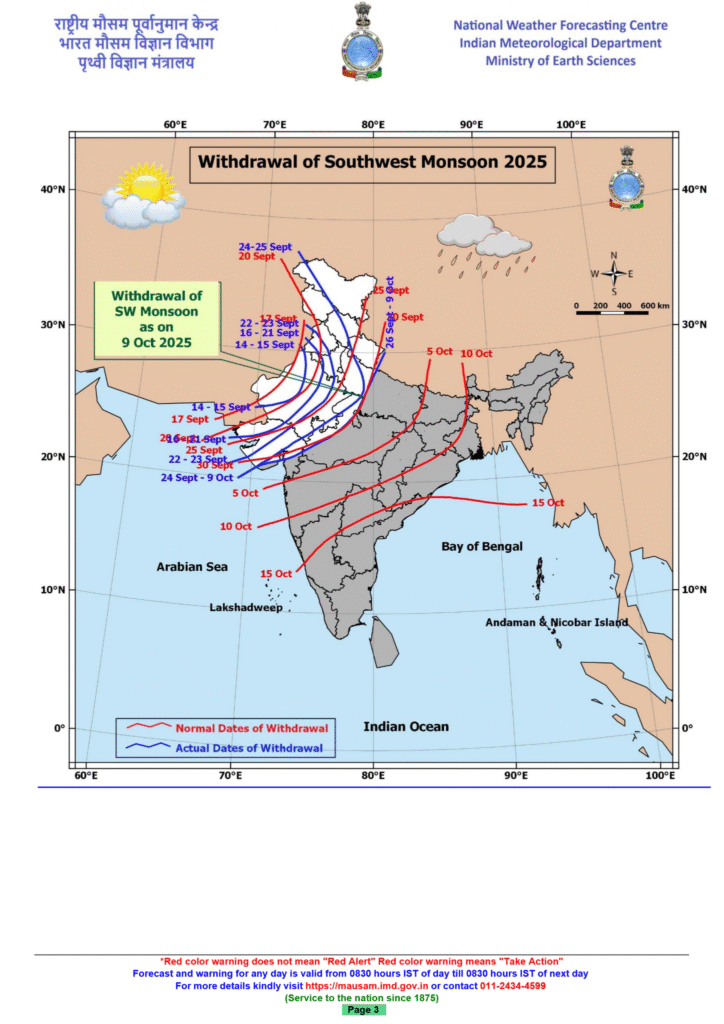
Southwest monsoon withdrawal
The monsoon is steadily retreating from several parts of the country, including Gujarat, Madhya Pradesh, Uttar Pradesh and Maharashtra. In its latest bulletin, the IMD said, “Conditions are favourable for further withdrawal of the southwest monsoon from remaining parts of Gujarat; some more parts of Madhya Pradesh and Uttar Pradesh and some parts of Maharashtra during the next 2-3 days.”
The well-marked low-pressure system, a remnant of Cyclone Shakhti, remains in the west-central Arabian Sea as of the morning of October 9, with its associated cyclonic circulation extending up to 5.8 km above sea level. It is forecast to continue moving east-southeastwards over the same area and is expected to further weaken into a general low-pressure area within the next 12 hours.
Yellow alert in Kerala
The IMD issued a yellow alert in Kerala for many districts, including Pathanamthitta, Idukki, Malappuram, Wayanad, and Kannur on Thursday, predicting heavy showers. For the period of October 9–12, the state is expected to experience light to moderate rainfall and thunderstorms, with isolated areas receiving heavy rainfall.
The IMD also predicted thunderstorms with gusty wind (speed reaching 30-40 kmph) in the state during the next four days.
Mainly clear sky in Delhi
Delhi will experience mainly clear skies starting today, October 9, following a period of rain and partly cloudy conditions. Maximum temperature in the national capital is expected to range between 30 and 32°C, while minimum is likely to remain around 18-20°C.
Heavy rain and thunderstorms are expected in Tamil Nadu
The IMD predicted heavy rainfall in various districts of Tamil Nadu on Thursday as a result of the emergence of two low-pressure systems, one over the southern peninsula and another over the Kanyakumari Sea.
Heavy rain is expected in districts such as Coimbatore, Nilgiris, Erode, Dharmapuri, Krishnagiri, Tirupattur, Vellore, Ranipet, Kancheepuram, and Tiruvallur, particularly in the ghats and high-altitude regions. Thunderstorms with lightning are also expected in certain regions.
Telangana weather update
The Met Office predicted a thunderstorm for 12 Telangana districts on Thursday. Thunderstorms with lightning and strong winds are very likely to occur in isolated areas of Bhadradri Kothagudem, Khammam, Nalgonda, Suryapet, Mahabubabad, Rangareddy, Hyderabad, Medchal Malkajgiri, Mahabubnagar, Nagarkurnool, Wanaparthy, and Jogulamba Gadwal districts. Meanwhile, Hyderabad and its surrounding areas will witness a partly cloudy sky.
Light to moderate rain in Northeast India is likely
According to the IMD bulletin, Northeastern states are likely to experience light to moderate rain and thunderstorms, along with isolated heavy rainfall, till Friday. Specifically, Assam, Meghalaya, Nagaland, Manipur, Mizoram, and Tripura are likely to experience isolated heavy rainfall on both days.
Arunachal Pradesh is also expected to have isolated heavy downpours on October 10. These weather conditions are occurring during the retreat of the Southwest Monsoon from parts of the country.
Weather forecast for South India
A period of increased rainfall activity, including isolated heavy to very heavy showers, is expected over south peninsular India for several days.
IMD Forecasts Increased Rainfall Over South Peninsular India for Next 3-4 Days
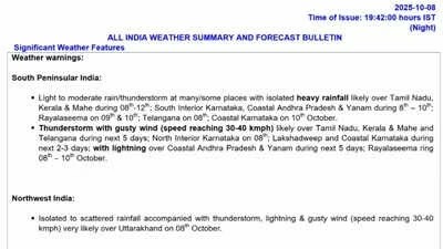
The India Meteorological Department (IMD) has forecast rainfall activity to likely increase over South Peninsular India for the next 3 to 4 days. According to the IMD, heavy rainfall will prevail over Tamil Nadu, Kerala, Mahe, South Interior Karnataka, Coastal Andhra Pradesh, Yanam and Rayalaseema during the next 2 to 3 days. Meanwhile, a thunderstorm with gusty winds will likely be over Lakshadweep and Coastal Karnataka today and tomorrow.
Over the Eastern and Northeastern parts of the country, heavy rainfall conditions will continue over parts of Odisha, Gangetic West Bengal, Assam, Meghalaya, Nagaland, Manipur, Mizoram and Tripura during the next 2 to 3 days.
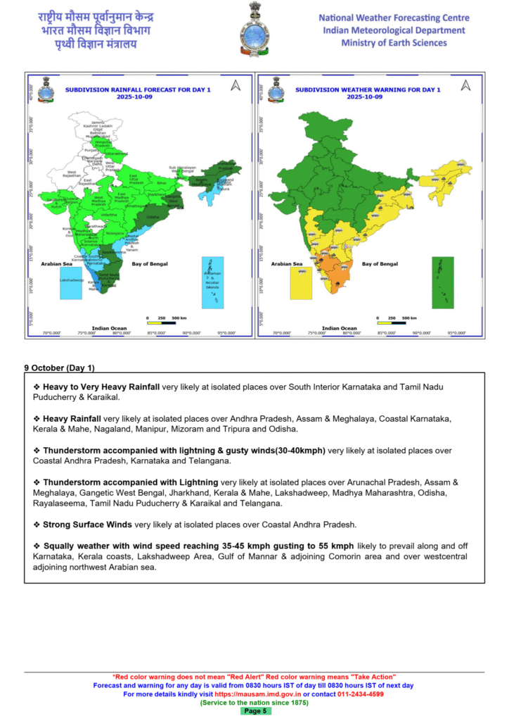
South Indian states like Tamil Nadu, Kerala, Mahe, Andhra Pradesh, and Coastal Karnataka are expected to experience light to moderate rain with isolated heavy showers from October 8 to 12. The IMD has issued alerts for several districts in these states, warning of thunderstorms accompanied by lightning and gusty winds reaching speeds of 30–40 km/h.
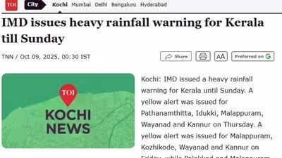
In Kerala, as per a report on the Times of India, a yellow alert has been declared for districts including Pathanamthitta, Idukki, Malappuram, Wayanad, and Kannur on Thursday; Malappuram, Kozhikode, Wayanad, and Kannur on Friday; and Palakkad and Malappuram on Saturday and Sunday. Thunderstorms with lightning and gusty winds of 30–40 km/h are expected in isolated areas across the state. Fishermen are strongly advised against venturing into the sea due to squally weather with wind speeds of 35–45 km/h, gusting up to 55 km/h, likely along the Kerala coast.
The current weather developments are attributed to the remnants of Cyclonic Storm ‘Shakti,’ which has weakened into a well-marked low-pressure area with a diminishing cyclonic circulation. Additional weather influences include a trough from south Chhattisgarh to the Gulf of Mannar and upper air cyclonic circulations over the Comorin region and the north Bay of Bengal.
Monsoon withdrawal in North-Western States
Meanwhile, the most recent IMD bulletin, has indicated that conditions are favourable for the southwest monsoon to withdraw from the remaining parts of Gujarat, , over the next two to three days. The line of withdrawal continues to pass through Veraval, Bharuch, Ujjain, Jhansi, Shahjahanpur.
In Madhya Pradesh, the retreat of the monsoon has led to pleasant weather conditions, with cooler nights and cloudy days. The night temperature in Bhopal has dropped below 20°C, and the day temperature of 30.7°C is three degrees below normal. The meteorological department has also issued warnings for thunderstorms and lightning in several districts across the state, including Vidisha, Raisen, Sehore, and Ujjain.
In Eastern India, light to moderate rain with isolated heavy showers is expected in Odisha from October 9 to 11. The IMD has issued warnings for thunderstorms and lightning in several districts across the state.
In the Northeastern states, heavy rainfall is likely in Assam, Meghalaya, Nagaland, Manipur, Mizoram, and Tripura from October 8 to 10. The IMD has advised residents to remain alert and take necessary precautions.
The IMD has also issued the following safety advisories: Fishermen are advised not to venture into the sea along the Kerala coast, Gulf of Mannar, and adjoining Comorin area due to squally weather with wind speeds of 35–45 km/h, gusting up to 55 km/h, likely to prevail from October 8 to 13. Travelers are advised to monitor local weather updates and plan their journeys accordingly.
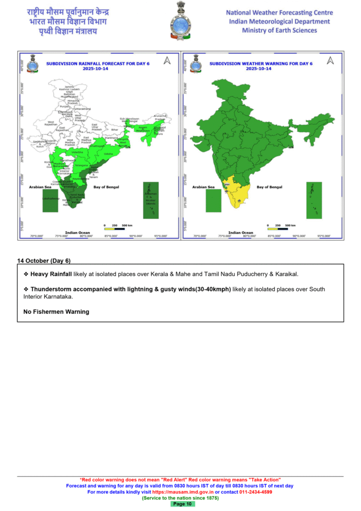
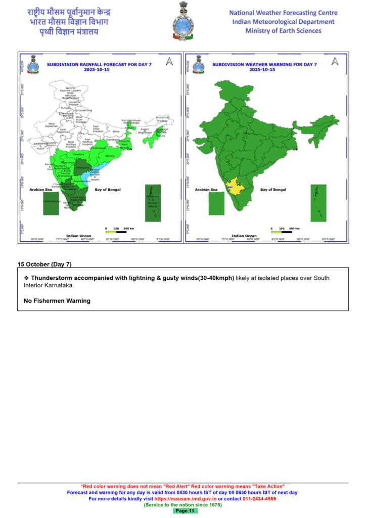
Forecast for October 10–14, 2025:
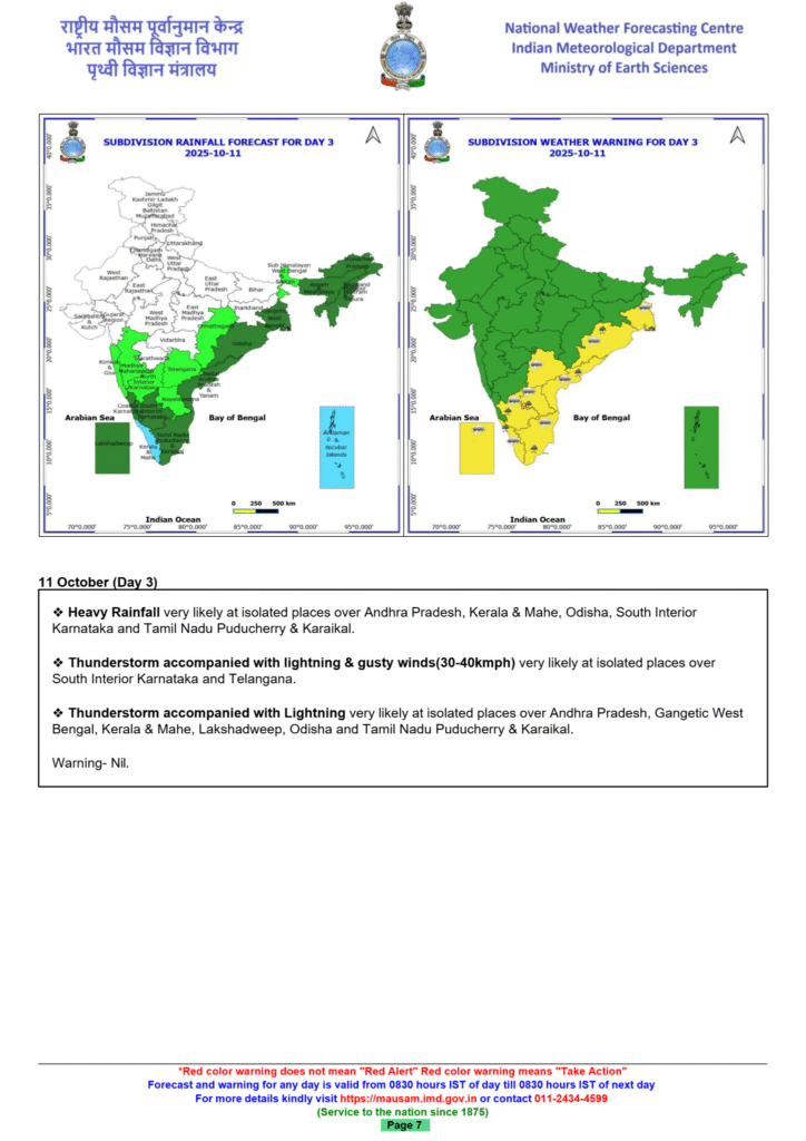
- Andhra Pradesh and Yanam: Expected to experience light to moderate rain with isolated heavy rainfall through October 12. Thunderstorms with lightning and gusty winds are also likely.
- Karnataka: Coastal Karnataka and South Interior Karnataka are forecast to receive isolated heavy rainfall. Thunderstorms with lightning and gusty winds are also possible.
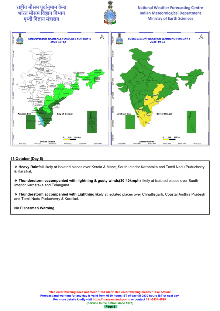
- Kerala and Mahe: Isolated heavy rainfall is forecast to continue through October 14.
- Tamil Nadu, Puducherry, and Karaikal: The region will see isolated heavy rainfall through October 14.
Thunderstorms, heavy rain forecast across Andhra until October 11
Synopsis
The IMD forecasts thunderstorms with lightning and strong winds across Andhra Pradesh for five days until October 11. Heavy rain is expected in Rayalaseema, while coastal regions and Yanam will experience thunderstorms and gusty winds. Red and orange alerts have been issued for several districts, urging residents to stay indoors and remain vigilant.

The IMD forecast thunderstorms accompanied by lightning and strong surface winds across parts of Andhra for five days, until October 11.
According to the India Meteorological Department, heavy rain is likely at isolated places over Rayalaseema, while North Coastal Andhra Pradesh (NCAP), Yanam, South Coastal Andhra Pradesh (SCAP) and Rayalaseema are expected to experience thunderstorms and gusty winds.
“Thunderstorm activity accompanied by lightning is expected over several districts, with wind speeds reaching up to 40 km per hour at isolated locations,” the department said in a press release.
The department said on October 8, heavy rainfall is likely at isolated places over Rayalaseema, while thunderstorms accompanied by lightning will continue over NCAP, Yanam, SCAP and Rayalaseema.
From October 9 to 11, heavy rain is expected at isolated places over Rayalaseema, with thunderstorms and lightning forecast for several parts of the state, the department added.
Strong surface winds with speeds between 30-40 km per hour are likely at a few places, especially in the northern coastal districts and the Yanam region.
Meanwhile, the Andhra Pradesh State Disaster Management Authority (APSDMA) issued a red alert for Vizianagaram, Visakhapatnam, Anakapalli and Kakinada districts for Tuesday, warning of “moderate to heavy rain accompanied by lightning” in the next few hours.
“Orange and yellow alerts have been issued for Srikakulam, Parvatipuram, Manyam, Alluri Seetharam Raju, Nellore, Palnadu, Prakasam and Nandyal districts, with the possibility of light to moderate rainfall and thunderstorms,” APSDMA managing director Prakhar Jain said in a press release.
A red alert indicates heavy to extremely heavy rain of over 20 cm in 24 hours, while an orange alert means very heavy rain (6 cm to 20 cm). A yellow alert means heavy rainfall between 6 to 11 cm.
Monsoon withdrawal update
The southwest monsoon’s withdrawal, which began in September, is progressing across parts of northwestern and central India.
Recent developments:
- Progress of withdrawal: The monsoon’s retreat is advancing across Gujarat, Madhya Pradesh, Uttar Pradesh, and parts of Maharashtra.
- Reason for recent slowdown: The withdrawal was temporarily delayed by active weather systems over the Bay of Bengal.
- Projected completion: According to IMD Hyderabad, the southwest monsoon is likely to have fully withdrawn from Telangana by October 15.
Other regional forecasts
Other parts of India are also experiencing weather conditions influenced by the retreating monsoon and other atmospheric circulation patterns.
- Northeast India: Isolated heavy rainfall is likely in Assam, Meghalaya, Nagaland, Manipur, Mizoram, and Tripura on October 10.
- East India: Odisha is expected to receive isolated heavy rainfall between October 9 and 12.
- Delhi-NCR: The sky is expected to remain clear, with temperatures gradually increasing after an earlier spell of rain.
Factors influencing the weather
Several weather systems are contributing to the current conditions:
- Remnants of Cyclone Shakhti: A well-marked low-pressure area, which is the remnant of Cyclone Shakhti over the west-central Arabian Sea, has weakened and is influencing rainfall.
- Cyclonic circulations: Other cyclonic circulations over south Bangladesh and the Comorin area are also persisting and affecting weather patterns.
- Northeast monsoon: Concurrently with the withdrawal of the southwest monsoon, the northeast monsoon rainfall activity is beginning over the southeast peninsular region.