List of Oldest Roads in the World that Still Exist

Many of the roads we use today have some of the ancient origins, whether a path that has been tread earlier, or a pathway used by traders. Some of the earliest roads were built so people, trade, armies, and pilgrims could travel long distances. Over time, some of these roads have changed, been rebuilt, or preserved in parts, but they still tell stories of human movement, culture, and engineering from hundreds to thousands of years ago.
Some of the roads mentioned below fully exist, while some exist in parts. However, all these roads have the capacity to take you to the glorious past
Here’s a list of some of the oldest roads in the world, where they are, how they were used in the past, and what remains of them today.
1. The Road to Giza, Egypt
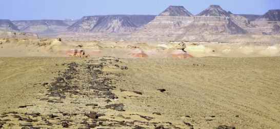
This road is considered one of the oldest known paved roads in world history. It has been in use for more than 4,000 years. Stretching about 7.5 miles (around 12 km), it connects the southwest of Cairo to Lake Moeris, which links to the Nile. Builders of the ancient days used this road to transport huge limestone blocks to build the pyramids of Giza. Nowadays, only parts of the old route remain, but its history is still strong.
Oct 1, 2025, 11:52 IST
Many of the roads we use today have some of the ancient origins, whether a path that has been tread earlier, or a pathway used by traders. Some of the earliest roads were built so people, trade, armies, and pilgrims could travel long distances. Over time, some of these roads have changed, been rebuilt, or preserved in parts, but they still tell stories of human movement, culture, and engineering from hundreds to thousands of years ago.
Some of the roads mentioned below fully exist, while some exist in parts. However, all these roads have the capacity to take you to the glorious past
Here’s a list of some of the oldest roads in the world, where they are, how they were used in the past, and what remains of them today.
2. The Nakasendo Highway, Japan

The Nakasendo Highway, built in Japan, dates back to the 17th century, although it is considered to be built on even older paths. It runs between Kyoto and Edo (modern Tokyo), about 310 miles long. The road was originally used for travel by foot and horse, because wagons were rare back then. In the present day, hikers can still walk some parts of this path, passing old inns and countryside that feel very similar to how they might have looked centuries ago.
3. The Silk Road, Rome to China

Many of the roads we use today have some of the ancient origins, whether a path that has been tread earlier, or a pathway used by traders. Some of the earliest roads were built so people, trade, armies, and pilgrims could travel long distances. Over time, some of these roads have changed, been rebuilt, or preserved in parts, but they still tell stories of human movement, culture, and engineering from hundreds to thousands of years ago.
Some of the roads mentioned below fully exist, while some exist in parts. However, all these roads have the capacity to take you to the glorious past
Here’s a list of some of the oldest roads in the world, where they are, how they were used in the past, and what remains of them today.
One of the most famous and most busy old trade routes, the Silk Road used to connect Rome in the west to Chang’an (present-day Xi’an, China) in the east. It started around 200 BC and was critical for trade for centuries, carrying silk, goods, ideas, religions, and technology. Parts of this network of paths and roads are still visible, especially in Central Asia and along borders between countries.
ALSO READ: List of Oldest Bridges in the World that Still Exist
4. The Ridgeway, UK
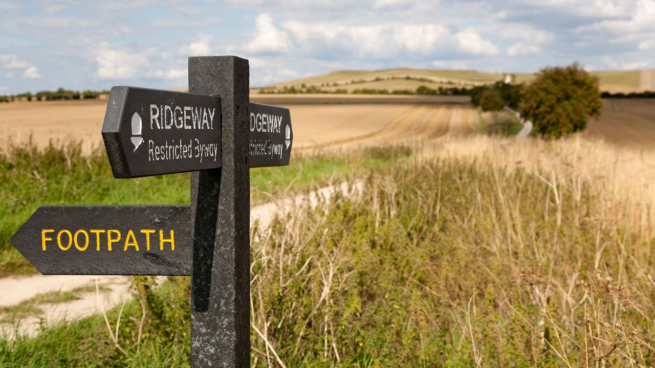
The Ridgeway is one of Britain’s oldest roads. It’s part of the Icknield Way, with sections used for over 5,000 years. Originally used by traders, travelers, and druids, it runs across the uplands from southern to eastern England. However, now this route is protected and used more for hiking and exploring ancient landmarks, rather than as a major travel route.
5. The Yuen Tsuen Ancient Trail, Hong Kong

This trail has linked Yuen Long and Tsuen Wan in Hong Kong for centuries. It was once a difficult path used by villagers and traders. Even now, amid the busy city, parts of the trail remain green and calm—giving walkers a chance to feel history under their feet.
6. The Old Great North Road, Australia
This road is a masterpiece of 19th-century engineering. Built by convict laborers between Sydney and Newcastle in New South Wales, it follows some older Aboriginal paths. The route shows old road techniques, including stone formations and culverts. Parts are preserved as heritage sites, while others have been replaced by modern roads.
7. The Old North Trail, North America

This was an important path used long ago by the Blackfeet tribe. Stretching from Canada into Montana and down toward Mexico, it was used for trade, travel, hunting, and cultural journeys. Some parts of this road are preserved in places like Glacier National Park.
8. The Khmer Highway, Cambodia / Thailand

The Khmer Highway, once built to connect Angkor (Cambodia) with Phimai (Thailand), is around 225 km long. It was part of the Khmer Empire’s road network. Although nature has reclaimed many portions of the road, the ruins of temples and road fragments can still be found on the route.
9. The Persian Royal Road, Turkey to Iran

Oct 1, 2025, 11:52 IST
Many of the roads we use today have some of the ancient origins, whether a path that has been tread earlier, or a pathway used by traders. Some of the earliest roads were built so people, trade, armies, and pilgrims could travel long distances. Over time, some of these roads have changed, been rebuilt, or preserved in parts, but they still tell stories of human movement, culture, and engineering from hundreds to thousands of years ago.
Some of the roads mentioned below fully exist, while some exist in parts. However, all these roads have the capacity to take you to the glorious past
Here’s a list of some of the oldest roads in the world, where they are, how they were used in the past, and what remains of them today.
This road is considered one of the oldest known paved roads in world history. It has been in use for more than 4,000 years. Stretching about 7.5 miles (around 12 km), it connects the southwest of Cairo to Lake Moeris, which links to the Nile. Builders of the ancient days used this road to transport huge limestone blocks to build the pyramids of Giza. Nowadays, only parts of the old route remain, but its history is still strong.
This road is a masterpiece of 19th-century engineering. Built by convict laborers between Sydney and Newcastle in New South Wales, it follows some older Aboriginal paths. The route shows old road techniques, including stone formations and culverts. Parts are preserved as heritage sites, while others have been replaced by modern roads.
ALSO READ: How did the First Telephone Look Like? Check how Much Different it is from Modern Telephone
10. The King’s Highway, Egypt to Syria
This ancient route had been important in both biblical and classical times. Running from Egypt, across Sinai, to Syria, the Highway linked many pilgrimage sites, trading points, and cultural centers. Parts of the road are still used today in modern countries.
11. Via Augusta, Spain

Named after Emperor Augustus, this Roman road connected Cádiz (in Andalusia) north through Catalonia up toward the Pyrenees, and toward Rome. It played a major role in moving soldiers, goods, and culture in Roman Hispania.
These oldest roads that still exist in some or other way represent that people have always moved, seeking trade, knowledge, religion, or a better life. Although many of these roads have changed or vanished in parts, they remain living memories of our past. Visiting or studying them reminds us how ancient our journeys are, and how much those old ways shaped the modern world.
12.The Road to Giza, Egypt
Built around 2600 BC, this is considered the world’s oldest known paved road. It connected ancient quarries to the Nile River for transporting stone blocks used in monumental structures like the Pyramids of Giza. Portions of the basalt-paved road are still visible
The road described is the Lake Moeris Quarry Road, the world’s oldest known paved road, dating back to the Old Kingdom (around 2600 BC). This basalt-paved road transported stone blocks from quarries to a quay on the shores of Lake Moeris, allowing them to be floated down to Giza via the Nile River to build the Pyramids of Giza.
Details of the Lake Moeris Quarry Road
- Purpose:To transport basalt blocks for the royal sarcophagi and mortuary temples at Giza.
- Location:Connected a quarry southwest of Cairo to Lake Moeris in the Faiyum District.
- Construction:Made of sandstone and limestone slabs, and even included logs of petrified wood to prevent sleds from sinking into the sand.
- Dimensions:The road was 7.5 miles long and averaged 6.5 feet wide.
- Transport System:The blocks were pulled on sleds along the paved road to the lake. When the Nile flooded, its waters would reach a gap in the hills, enabling the blocks to be floated down to Cairo.
- Significance:It is the oldest road in the world with a significant portion of its original pavement still preserved and represents a major engineering feat by the ancient Egyptians.
13 The Ridgeway, United Kingdom
The Ridgeway in the United Kingdom is a National Trail and one of Britain’s oldest roads, running for 87 miles (139 km) through southern England and forming part of the historic Icknield Way. This ancient trackway follows high ground and is rich with prehistoric sites like Stone Age long barrows and Bronze Age round barrows, as well as Iron Age forts. Today, it is a protected route for hikers, runners, cyclists, and horse riders, offering a blend of open downland and woodland scenery.
Key Features:
- Historic Significance:The Ridgeway is considered Britain’s oldest road, used for over 5,000 years by travellers, drovers, and soldiers.
- Part of the Icknield Way:It is a component of the larger Icknield Way, a prehistoric trackway that once stretched over 360 miles from the Dorset coast to the Wash in Norfolk.
- Protected Trail:It is a designated National Trail and a protected route, making it a popular destination for long-distance walking.
- Diverse Landscape:The trail offers varied scenery, from the open chalk downland of the North Wessex Downs to the more wooded areas of the Chilterns.
- Rich Archaeology:It passes through an area with numerous archaeological monuments, including white horses carved into the chalk hills.
- Wildlife:The Ridgeway also provides habitats for various wildlife, including butterflies and small mammals.
Activities:
- Walking:The 87-mile trail is an ideal route for long-distance walking and training.
- Cycling:Cyclists can enjoy the varied terrain, though the route is challenging.
- Horse Riding:The trail is suitable for horse riders, offering a scenic route across the uplands.
- History Enthusiasts:Visitors can explore the numerous prehistoric and historic sites along the route.
14. The Grand Trunk Road, South Asia
The Grand Trunk (GT) Road is a historic, multi-national, major highway stretching over 2,500 kilometers, connecting Central Asia to the Indian subcontinent. It links cities across Afghanistan, Pakistan, India, and Bangladesh and has served as a vital artery for trade, communication, and military movement for millennia. While its origins date back to antiquity, Sher Shah Suri significantly rebuilt the road in the 16th century, and it was further developed under British rule, eventually becoming a key part of India’s modern highway network.
History and Naming
- Ancient Origins:The road’s origins are ancient, with its predecessor, the Uttarapath or Badshahi Sadak, being mentioned in texts dating back to at least 333 BC.
- Sher Shah Suri:The Afghan emperor Sher Shah Suri (16th century) extensively rebuilt and expanded the road, naming it the Sadak-e-Azam (“The Grand Road”).
- British Era:The British Colonial administration renamed it the “Grand Trunk Road” and extended it from Calcutta (now Kolkata) to Peshawar, spanning a large portion of British India.
Route and Countries
- Current Path:The GT Road, or parts of it, connects Kabul in Afghanistan to Teknaf in Bangladesh.
- Key Countries:It traverses the territories of Afghanistan, Pakistan, India, and Bangladesh, linking major cities along its path.
- Indian Highways:In modern India, the Grand Trunk Road is largely designated as National Highway 19 (formerly NH2) in the south of Delhi, and National Highway 1 (previously NH1) in the north.
Significance
- Trade and Communication:For centuries, the GT Road was a primary route for trade, postal services, and travel.
- Military and Conquest:The road also facilitated the movement of troops and invaders, with both Afghan and Persian invaders and later British troops using it for rapid transit across the plains of North India.
- Cultural Exchange:It played a vital role in connecting the eastern and western parts of the Indian subcontinent and beyond, linking Central Asia to the Indian culture.
- Modern Importance:The road continues to be a significant transportation corridor, with parts of it integrated into India’s Golden Quadrilateral project.
15. The Via Appia (Appian Way), Italy
Key Characteristics
UNESCO World Heritage Site:The road has been recognized as a World Heritage site, highlighting its technical skill in road construction and its historical importance.
Construction:Built in 312 BCE by Roman censor Appius Claudius Caecus.
Purpose:Initially a strategic military road to facilitate troop movement and conquest.
Extension:Extended from Rome to Brindisi, serving as a vital artery for trade, communication, and culture.
Paving:Engineered with large, expertly fitted stone slabs, allowing it to be used in all weather conditions and contributing to its extraordinary durability.
Monuments:Lined with numerous mausoleums, tombs, and ancient villas, creating a vast necropolis for Rome’s elite.
Milestones:Milestones were placed along the road, featuring imperial inscriptions and measuring distances.
Historical Significance:Symbolizes Roman engineering and power, connecting various parts of the empire and serving as a major route to the eastern Mediterranean.
Preservation:Parts of the Appian Way remain well-preserved, featuring ancient paving stones that visitors can walk on, alongside ancient ruins and monuments.
16.Via Augusta, Spain
Built by the Romans under Augustus, this route linked Andalusia with the Pyrenees. Roman milestones and surviving sections are visible in modern Spain.
The Via Augusta was the longest and one of the most important Roman roads in Hispania (ancient Spain), running from Cádiz to Narbonne in France, where it connected with the Via Domitia. Today, sections of the ancient route are followed by the popular Camino Via Augusta walking and cycling trail, connecting historic cities like Seville and Tarragona. Modern travelers can explore remaining sections, historical markers, and enjoy the landscapes of the route, which is well-signposted and accessible by public transport.
Route and Significance
- A Roman Powerhouse:This Roman road was crucial for transport and communication, connecting major cities, military outposts, and colonies across the Iberian Peninsula.
- The Spanish Section:The Spanish portion of the Via Augusta stretched from the port city of Gades (Cádiz) to Tarraco (Tarragona) and then onward to La Jonquera, the border with France.
Modern-Day Exploration
- Pilgrimage and Cycling:The Camino Via Augusta is a popular pilgrimage and cycling route that follows parts of the ancient path.
- Historical Sites:The route allows travelers to discover Roman influence in areas like the intellectual center of Corduba (Córdoba) and other settlements like Saetabis and Aurgi.
- Wayfinding:While some sections are well-preserved, travelers will encounter a mix of original paths, modern roads, and well-marked trails with unique yellow and blue signage to guide the way.
- Accessibility:Local municipalities have incorporated sections of the Via Augusta into hiking and cycling networks, making it accessible for various forms of travel, sometimes utilizing public transport to bridge gaps in the route.
17. Watling Street, England
Originally an Iron Age track, it was upgraded by the Romans after their conquest. Many sections now form the base of the A2 and A5 roads, with some walkable stretches and archaeological markers.Watling Street is a historic route in England, running from Dover and London in the southeast, via St Albans to Wroxeter. The road crosses the River Thames at London and was used in Classical Antiquity, Late Antiquity, and throughout the Middle Ages. It was used by the ancient Britons and paved as one of the main Roman roads in Britannia (Roman-governed Great Britain during the Roman Empire). The line of the road was later the southwestern border of the Danelaw with Wessex and Mercia, and Watling Street was numbered as one of the major highways of medieval England.
First used by the ancient Britons, mainly between the areas of modern Canterbury and St Albans using a natural ford near Westminster, the road was later paved by the Romans. It connected the ports of Dubris (Dover), Rutupiae (Richborough Castle), Lemanis (Lympne), and Regulbium (Reculver) in Kent to the Roman bridge over the Thames at Londinium (London). The route continued northwest through Verulamium (St Albans) on its way to Viroconium Cornoviorum (Wroxeter). Watling Street is traditionally cited as having been the location of the Romans’ defeat of Boudica, though precisely where on the route is disputed.
The Roman Antonine Itinerary lists sites along the route of Watling Street as part of a longer route of 500 Roman miles connecting Richborough with Hadrian’s Wall via Wroxeter. The continuation on to Blatobulgium (Birrens, Dumfriesshire) beyond Hadrian’s Wall in modern Scotland may have been part of the same route, leading some scholars to call this Watling Street as well, although others restrict it to the southern leg.
In the early 18th century, England’s first turnpike trust was established to pave the route through Bedfordshire and Buckinghamshire. In the early 19th century, the course between London and the Channel was paved and became known as the Great Dover Road.
The route from London to Wroxeter forms much of the A5 road. The route from Dover to London forms part of the A2 road. At various points along the historic route, the name Watling Street remains in modern use.
Name
The original Celtic and Roman name for the road is unknown, and the Romans may not have viewed it as a single path at all, since parts of it were assigned to two separate itineraries in one 2nd-century list. The modern name instead derives from the Old English Wæcelinga Stræt, from a time when “street” (Latin: via strata) referred to any paved road and had no particular association with urban thoroughfares. The Waeclingas (“people of Waecla“)[1] were a tribe in the St Albans area in the early medieval period.[1][2] The Anglo-Saxon name of St Albans was Wætlingaceaster referred to in a charter of 1005;[3] this would translate into modern English as “Watlingchester”.
The original Anglo-Saxon name for the section of the route between Canterbury and London was Casingc Stræt or Key Street, a name still borne by a hamlet on the road near Sittingbourne.[4] This section only later became considered part of Watling Street.[4]
Used as a boundary
Watling Street has been used as a boundary of many historic administrative units, and some of these are still in existence today, either through continuity or the adoption of these as by successor areas. Examples include:
- Watling Street was used as a boundary in the Treaty of Alfred and Guthrum and it is often inferred that this made the road the SW boundary of the Danelaw.[5]
- It is the boundary of Leicestershire and Warwickshire, this may be a legacy of the treaty described above.
- Watling Street forms part of the boundary of four London Boroughs (Harrow, Brent, Camden and Barnet) and is sometimes described as the boundary of West and North London.[6]
History
British

The broad, grassy trackway found by the Romans had already been used by the Britons for centuries. The main path led from Richborough on the English Channel to a natural ford in the Thames at Thorney Island,[7] Westminster, to a site near Wroxeter, where it split. The western continuation went on to Holyhead while the northern ran to Chester and on to the Picts in Scotland.[8]
Westminster ford
There is a longstanding tradition[citation needed] that a natural ford once crossed the Thames between Thorney Island (present-day Westminster) and the Lambeth/Wandsworth boundary.[9][better source needed] Its location means that it is possible that Watling Street crossed it.
Several factors may have slowed the river here, leading to the depositing of enough sediments to create a usable ford:[10]
- The bend in the Thames near Vauxhall Bridge.
- The two arms of the River Effra joining in that vicinity, depositing their own load, with the cross-flow causing the Thames to eddy and slow.
- Similarly the southern arm of the Tyburn, once joined the Thames at this point, on the northern bank.
- These factors mean the area is likely to have been the tidal head for some of the historic period.
Roman

The Romans began constructing paved roads shortly after their invasion in AD 43. The London portion of Watling Street was rediscovered during Christopher Wren‘s rebuilding of St Mary-le-Bow in 1671–73, following the Great Fire. Modern excavations date its construction to the winter from AD 47 to 48. Around London, it was 7.5–8.7 m (25–29 ft) wide and paved with gravel. It was repeatedly redone, including at least twice before the sack of London by Boudica‘s troops in 60 or 61.[11] The road ran straight from the bridgehead on the Thames[12] to what would become Newgate on the London Wall before passing over Ludgate Hill and the Fleet and dividing into Watling Street and the Devil’s Highway west to Calleva (Silchester). Some of this route is preserved beneath Old Kent Road.[13]
The 2nd-century Antonine Itinerary gives the course of Watling Street from “Urioconium” (Wroxeter) to “Portus Ritupis” (Richborough) as a part of its Second Route (Iter II), which runs for 501 MP from Hadrian’s Wall to Richborough:[14][15]
Battle of Watling Street
.jpg)
Main article: Defeat of Boudica § Location
Some site in the middle section of this route is supposed by most historians to have been the location of G. Suetonius Paulinus‘s decisive victory over Boudica‘s Iceni in AD 61.
Subsidiary routes
The two routes of the Antonine Itinerary immediately following (Iter III & IV) list the stations from Londinium to “Portus Dubris” (Dover) and to “Portus Lemanis” (Lympne) at the north eastern edge of the Romney Marsh, suggesting that they may have been considered interchangeable terminuses. They only differ in the distance to Durovernum: 14 and 17 Roman miles, respectively.[14][15] The route to Lemanis was sometimes distinguished by the name “Stone Street”; it now forms most of the B2068 road that runs from the M20 motorway to Canterbury. The route between Durovernum and the fortress and port at Regulbium (Reculver) on Kent’s northern shore is not given in these itineraries but was also paved and is sometimes taken as a fourth terminus for Watling Street. The Sixth Route (Iter VI) also recorded an alternate path stopping at Tripontium (Newton and Biggin) between Venonis (High Cross) and Bannaventa (Norton); it is listed as taking 24 Roman miles rather than 17.[14][15]
The more direct route north from Londinium (London) to Eboracum (York) was Ermine Street. The stations between Eboracum and Cataractonium (Catterick) were shared with Dere Street, which then branched off to the northeast. Durocobrivis (Dunstable) was the site of the path’s intersection with the Icknield Way. The Maiden Way ran from Bravoniacum (Kirkby Thore) to the fort at Epiacum (Whitley Castle) with its remarkable ramparts, and on to the Hadrian’s Wall fort of Magnis (Carvoran).
Saxon

By the time of the Saxon invasions, the Roman bridge across the Thames had presumably fallen into disrepair or been destroyed. The Saxons abandoned the walled Roman site in favour of Lundenwic to its west, presumably because of its more convenient access to the ford on the Thames. They did not return to Lundenburh (the City of London) until forced to do so by the Vikings in the late 9th century. Over time, the graveling and paving itself fell into disrepair, although the road’s course continued to be used in many places as a public right of way. “Watlingestrate” was one of the four roads (Latin: chemini) protected by the king’s peace in the Laws of Edward the Confessor.[16][17]
A number of Old English names testify to route of Watling Street at this time: Boughton Street in Kent; Colney Street in Hertfordshire; Fenny Stratford and Stony Stratford in Buckinghamshire; Old Stratford in Northamptonshire; Stretton-under-Fosse and Stretton Baskerville in Warwickshire. (The three adjacent settlements of All Stretton, Church Stretton, and Little Stretton in Shropshire; and Stretton Sugwas in Herefordshire have a Watling Street but they are not on the route).
Watling Street served as a significant traditional boundary for the ancient Forest of Arden, delineating its northern and western edges. The forest’s other historical boundaries included Icknield Street to the east, the Salt Road (now the modern Alcester to Stratford Road) to the south, and the Fosse Way to the southeast.[18]
Viking
Following the Viking invasions, the 9th-century Treaty of Alfred and Guthrum mentions Watling Street as a boundary.
Norman

It is assumed that the pilgrims in Chaucer‘s Canterbury Tales used the southeastern stretch of Watling Street when journeying from Southwark to Canterbury.[citation needed]
Modernity
Main: Great Dover Road, A2 Road, and A5 Road.
The first turnpike trust in England was established over Watling Street northwest of London by an act of Parliament, the Bedfordshire and Buckinghamshire Roads Act 1706 (6 Ann. c. 4), on 4 March 1707 in order to provide a return on the investment required to once more pave the road.[19] The section from Fourne Hill north of Hockliffe to Stony Stratford was paved at a cost of £7000[b] over the next two years. Revenue was below expectations; in 1709, the trust succeeded in getting a new act extending the term of their monopoly but not permitting their tolls to be increased. In 1711, the trust’s debts had not been discharged and the creditors took over receivership of the tolls. In 1716, a new act restored the authority of the trust under the supervision of another group appointed by the Buckinghamshire justices of the peace. The trust failed to receive a further extension of their rights in 1736 and their authority ended at the close of 1738. In 1740, a new act named new trustees to oversee the road, which the residents of Buckinghamshire described as being “ruined”.[20]
The road was again paved in the early 19th century at the expense of Thomas Telford. He operated it as a turnpike road for mail coaches from Ireland. To this purpose, he extended it to the port of Holyhead on Anglesey in Wales. During this time, the section southeast of London became known as the Great Dover Road. The tolls ended in 1875.

Much of the road is still in use today, apart from a few sections where it has been diverted. The A2 road between Dover and London runs over or parallel to the old path. A section of Watling Street still exists in the City of London close to Mansion House underground station on the route of the original Roman road which traversed the River Thames via the first London Bridge and ran through the City in a straight line from London Bridge to Newgate.[21] The sections of the road in Central London possess a variety of names, including Edgware Road and Maida Vale. At Blackheath, the Roman road ran along Old Dover Road, turning and running through the area of present-day Greenwich Park to a location perhaps a little north of the current Deptford Bridge. North of London, the road is designated mainly as the A5 between London and Shrewsbury. At various points along the route, the A5 leaves the Roman road to bypass settlements,[c] but its historic route invariably remains evident even where motor traffic is restricted or banned.
The name Watling Street is still used along the ancient road in many places, for instance in Bexleyheath in southeast London and in Canterbury, Gillingham, Strood, Gravesend, and Dartford in Kent. North of London, the name Watling Street still occurs in Hertfordshire (including St Albans), Bedfordshire (Dunstable), Buckinghamshire (Milton Keynes), Northamptonshire (Towcester), Leicestershire (Hinckley), Warwickshire (Nuneaton and Atherstone) and in Staffordshire (Cannock, Wall, Tamworth and Lichfield). (There are Watling Streets in Shropshire (Church Stretton)[22] and in Gwynedd (Llanrwst), but neither is on the original route.)
Other Watling Streets
Dere Street, the Roman road from Cataractonium (Catterick in Yorkshire) to Corstopitum (now Corbridge, Northumberland) to the Antonine Wall, was also sometimes known as Watling Street. A third Watling Street was the Roman road from Mamucium (Manchester) to Bremetennacum (Ribchester) to Cumbria. Preston, Lancashire, preserved a Watling Street Road between Ribbleton and Fulwood, passing the Sharoe Green Hospital.[23] Both of these may preserve a separate derivation from the Old English wealhas (“foreigner”) or may have preserved the memory of the long Roman road while misattributing its upper stages to better-preserved roads. The Roman road between Deva Victrix (Chester) and Condate (Northwich) is also known locally as Watling Street.