Isolated heavy to very heavy rainfall likely over sub-Himalayan West Bengal & Sikkim and northeast India during the week with possibility of isolated extremely heavy rainfall over sub-Himalayan West Bengal & Sikkim till June 21
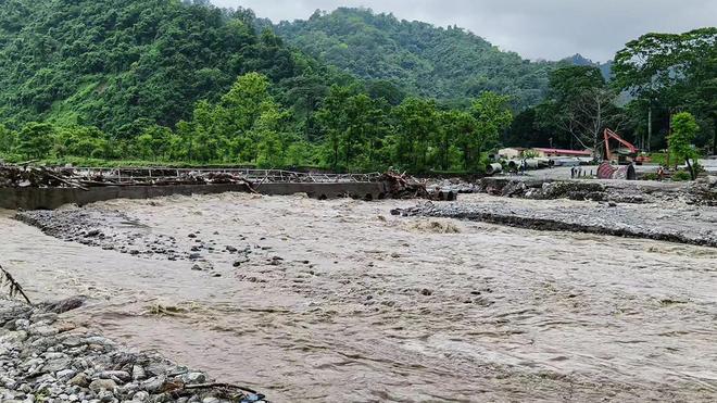
The Balasan River in full spate after heavy rainfall washes away the temporary hume pipe bridge at Dudhia, which connected Siliguri and Mirik, in Darjeeling on Friday (June 19, 2026). The India Meteorological Department (IMD) issued a weather warning, forecasting heavy rainfall activity across parts of the country. Isolated heavy to very heavy rainfall likely over sub-Himalayan West Bengal & Sikkim and northeast India during the week with possibility of isolated extremely heavy rainfall over sub-Himalayan West Bengal & Sikkim till Sunday (June 21, 2026).
Heat wave conditions very likely in isolated pockets over Konkan & Goa and Madhya Maharashtra on Saturday (June 20, 2026), east Uttar Pradesh & Vidarbha till June 25; Bihar, Telangana till June 21, 2026. What a ‘super’ El Niño would mean for India’s monsoon is the El Niño years since 1950 against IMD’s long-period rainfall series shows that, of roughly two dozen such years, about 15 produced a below-normal monsoon and around 10 tipped into outright deficiency; this correlation of close to three in five is strong enough to shape food and fiscal planning farm workers in Palakkad, Kerala, work in protection against the rain, in 2024. 2023 had been an El Nino year, and the sowing acreage increased in 2024. The United States’ National Oceanic and Atmospheric Administration (NOAA) confirmed this month that an El Niño has formed in the equatorial Pacific, and placed the odds at about 63% that it will strengthen into a “very strong” — colloquially, a “super” — event by the northern winter. India’s June rainfall, until 16th June, is roughly 35% below normal. The combination has revived a question that returns with every El Niño year: how reliably do the strongest of these events translate into a failed Indian monsoon? An El Niño is the periodic warming of the central and eastern equatorial Pacific that tends to weaken the South Asian monsoon and whose potency is measured by how far sea-surface temperatures in a reference patch of the Pacific climb above their long-term average. D.S. Pai, Chief Forecaster at the India Meteorological Department’s (IMD) Regional Meteorological Centre in Chennai, sets out the gradations: a departure of 0.5 to 1 degree Celsius is classed as ‘weak,’ 1 to 1.5 as ‘moderate,’ 1.5 to 2 as ‘strong’, and anything beyond 2 degrees as ‘very strong.’ “People call that very strong … as you wish, super,” he told The Hindu, adding that some forecasts suggest the current event could approach a record of around 2.5 degrees. The latest weather bulletin from the Regional Meteorological Centre on Saturday (June 20, 2026) said that a significant shift in weather patterns was expected from Sunday, paving the way for the onset of the Southwest Monsoon. India’s rainfall deficit at 35% as monsoon progress stalls faces 63% deficit as monsoon’s first round loses momentum; govt. directs crop-wise contingency plans, puts around 200 districts under priority monitoring, orders weekly reviews in June, the first of the monsoon months, is not unusual, it assumes additional significance in a year that forecasters globally have warned will likely be a ‘Super El Niño’ year.

Over a week past the monsoon’s normal arrival date, the rain clouds have yet to reach Mumbai, driving India’s nationwide monsoon deficit to 35% on June 16. The shortfall in rainfall is concentrated in the regions the monsoon has failed to cover — Maharashtra, the Konkan coast, and the adjoining regions of central India — where its northward progress has been stalled for several days.
IMD forecasts late-night rain in Delhi
Delhi recorded a maximum temperature of 40.2 degrees Celsius on Saturday (June 20, 2026), 1.6 notches above normal, as the city experienced hot and humid conditions amid a likely delay in the arrival of the southwest monsoon.
The weather office said very light rain accompanied by thunderstorms is likely in isolated parts of the city during the night.
For Sunday (June 21, 2026), the India Meteorological Department (IMD) has forecast a generally cloudy sky with thunderstorms and rain. The maximum and minimum temperatures are likely to settle around 39 degrees Celsius and 28 degrees Celsius, respectively.
What a ‘super’ El Niño would mean for India’s monsoon
The United States’ National Oceanic and Atmospheric Administration (NOAA) confirmed this month that an El Niño has formed in the equatorial Pacific, and placed the odds at about 63% that it will strengthen into a “very strong” — colloquially, a “super” — event by the northern winter. India’s June rainfall, until 16th June, is roughly 35% below normal. The combination has revived a question that returns with every El Niño year: how reliably do the strongest of these events translate into a failed Indian monsoon?

What a ‘super’ El Niño would mean for India’s monsoon
Explore the implications of a potential ‘super’ El Niño on India’s monsoon, rainfall patterns, and climate impact.
IMD weather highlights
The IMD has highlighted significant weather developments across the country, including the further advance of the southwest monsoon, heavy rainfall activity in several regions, and heat wave conditions in isolated areas.
(i) Conditions are favourable for further advance of southwest monsoon into some more parts of Maharashtra, Telangana, Odisha, Jharkhand & Bihar, and some parts of Chhattisgarh around June 23, 2026.
(ii) Isolated heavy to very heavy rainfall likely over sub-Himalayan West Bengal & Sikkim and northeast India during the week with possibility of isolated extremely heavy rainfall over sub-Himalayan West Bengal & Sikkim till June 21.
(iii) Heat wave conditions very likely in isolated pockets over Konkan & Goa and Madhya Maharashtra today, East Uttar Pradesh & Vidarbha till June 25; Bihar, Telangana till June 21, 2026.
IMD warns of isolated heavy to very heavy rainfall in several regions
The India Meteorological Department (IMD) has issued a weather warning, forecasting heavy rainfall activity across parts of the country. Isolated heavy to very heavy rainfall is likely over sub-Himalayan West Bengal, Sikkim and the northeastern States during the week. There is also a possibility of isolated extremely heavy rainfall over sub-Himalayan West Bengal and Sikkim till June 21, 2026. The southwest monsoon typically arrives in Tamil Nadu by the first week of June, delivering its primary rainfall to the western and interior districts while leaving the coastal regions, including Chennai, largely in a rain shadow. Tamil Nadu is a rain shadow area to South West Monsoon (SWM) nearly 32
percent of the total annual rainfall of Tamilnadu is received from this monsoon. Farmers
of Dharmapuri, Krishnagiri, Salem, The Nilgris and Kanyakumari are benefitted from
this seasonal rainfall to take up strategic farm decisions.
District level rainfall forecast for the ensuing Southwest monsoon,2018 (June to September) over Tamil Nadu was developed at Agro Climate Research Centre, Tamil Nadu Agricultural University, Coimbatore based on the Southern Oscillation Index of summer season and Sea Surface Temperature values of Pacific and Indian Oceans using Australian Rainman International V.4.3.Software. The rainfall data collected from Tamil Nadu Agricultural University Stations and India Meteorological Department were used to represent the district rainfall information. Rainfall expected during Southwest monsoon, 2018 with 60 per cent probability is given below. Normal Rainfall (± 19% from mean seasonal rainfall) is expected for 27 districts of Tamil Nadu viz., Chennai, Coimbatore, Cuddalore, Dharmapuri, Erode,
Karur, Kancheepuram, Kanyakumari, Krishnagiri, Madurai, Namakkal, Nagapattinam, Perambalur, Ramanathapuram, Salem, Sivagangai, Theni, Tirunelveli, Trichy, Tiruvarur, Thanjavur, The Nilgiris, Tiruvallur, Tiruvannamalai, Villupurum, Virudhunagar and Vellore. Deficit Rainfall (> -20% to -59 % from mean seasonal rainfall) is expected for five districts of Tamil Nadu viz., Ariyalur, Dindigul, Pudukottai, Tiruppur and Tutucorin. South West Monsoon Forecast for Tamil Nadu-2018 (District Wise)
S.
Districts
Long Period
Average
Rainfall (mm)
Expected
Rainfall (mm)
Per cent
Deviation Category No
1 The Nilgiris 759.9 772 1.6 Normal
2 Kanyakumari 477.4 541 13.3 Normal
3 Vellore 466.1 532 14.1 Normal
4 Chennai 439.1 414 -5.7 Normal
5 Kancheepuram 490.8 451 -8.1 Normal
6 Salem 440.6 391 -11.3 Normal
7 Tiruvallur 451.6 428 -5.2 Normal
8 Tiruvannamalai 468.1 396 -15.4 Normal
9 Krishnagiri 399 412 3.3 Normal
10 Dharmapuri 393.4 372 -5.4 Normal
11 Pudukottai 350.6 260 -25.8 Deficit
12 Cuddalore 383.1 356 -7.1 Normal
13 Ariyalur 392 309 -21.2 Deficit
14 Villupurum 408.3 390 -4.5 Normal
15 Namakkal 339.3 376 10.8 Normal
16 Perambalur 290.7 292 0.4 Normal
17 Sivagangai 301 292 -3.0 Normal
18 Trichy 293.9 271 -7.8 Normal
19 Maduari 335.9 326 -2.9 Normal
20 Thanjavur 318.4 358 12.4 Normal
21 Dindugal 295.4 234 -20.8 Deficit
22 Nagapattinam 286.1 278 -2.8 Normal
23 Thiruvarur 296.4 298 0.5 Normal
24 Virdhunagar 196.8 229 16.4 Normal
25 Erode 229.8 200 -13.0 Normal
26 Karur 213.6 189 -11.5 Normal
27 Coimbatore 189.8 213 12.2 Normal
28 Tiruppur 154.8 123 -20.5 Deficit
29 Theni 158.4 169 6.7 Normal
30 Ramanathapuram 149.3 175 17.2 Normal
31 Tirunelveli 142.4 126 -11.5 Normal
32 Tuticorin 74.9 60 -19.9 Deficit
Category : Remarks
Normal +, : – ±19 % from Long Period Average Rainfall (mm)
Deficit >-:1> -20% to -59% from Long Period Average Rainfall (mm)
The state generally experiences the following conditions during this season:
- Rainfall Distribution: Heavy to very heavy rains frequently lash the Nilgiris, Coimbatore, Erode, and Theni districts, feeding major hydel reservoirs.
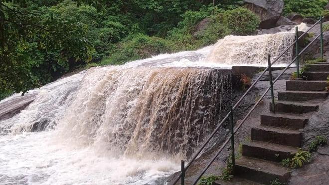
Coimbatore steps up monsoon preparedness officials were instructed to keep equipment such as excavators, power saws and sandbags ready for immediate deployment to clear fallen trees, landslides and road blockages has closed Kovai Courtallam to visitors following a surge in water flow caused by heavy rain in the Western Ghats on Saturday.
Coimbatore district has intensified its preparedness for the southwest monsoon as widespread rains continues across the region.
Weather Patterns: The rest of the state experiences hot and dry weather with occasional thunderstorms and strong westerlies that help cool the region by evening. Places to Visit in Monsoon in Tamil Nadu state of Tamil Nadu witnesses a considerable amount of rainfall during the monsoon season that starts in the month of June and ends in September. At the beginning of the season, the mercury falls down considerably yet the climate conditions remain hot and humid. The monsoon season in Tamil Nadu is meant for all those who love to spend their vacation in the lap of nature. Hill stations are the best places to visit during monsoon in Tamil Nadu. As the rain begins the entire region of any hill station enlivens with resplendent green sights. However, there are more places in Tamil Nadu where you can adore the similar experience in the monsoon season. Meghamalai mountain ranges are first on that list. Amidst the verdant greenery and misty environ, Meghamalai will surely give you some soothing and relaxing vacation time in the mountains during monsoon season.
Conjures up the images of exhilarating waterfalls, Courtallam is amongst must-visit places in South India in monsoon season. The ‘Spa of India’ Courtallam is the best monsoon tourism destination in Tamil Nadu for all those looking for a wellness holiday. Coonoor – The sister hill station of Ooty, is popular for its trekking trails and the famous Nilgiri Teas. The monsoon season augments the exuberant beauty of the place that will surely leave a mark on your memory. Similarly, Yercaud and Kodaikanal are the other hill stations that are worth visiting in Tamil Nadu during monsoon season. Apart from hill stations, Kanyakumari is the next best place to enjoy monsoon in Tamil Nadu. Enclosed by water, the southernmost tip of India’s mainland – Kanyakumari is one of the best places to relish the monsoon shower while standing on the shore of the sea and witnessing the surreal confluence of sun and sea in the evening.

Relief at last, Tamil Nadu to get rainfall in next 24 hours, predicts Met Dept meteorological department also predicted rains in Chennai on Thursday evening or night.

Relief at last, Tamil Nadu to get rainfall in next 24 hours, predicts Met Dept have some good news in store for the people of Tamil Nadu according to the Regional Meteorological Centre (RMC) in Chennai. The Meteorological department has announced that there will be scattered rainfall in different parts of the state soon.
“There will be rains in different parts of Tamil Nadu. There might be heavy rainfall in some places. However, we cannot exactly tell the total quantity of the rain. As of now, it will be moderate rains in many places,” RMC told TNM.
The meteorological department also predicted rains in Chennai on Thursday evening or night. The rain will be light or moderate, says the prediction.
Tamil Nadu Weatherman predicted rains for Chennai and the nearby districts. “Chennai – has one of the best chances evening / tonight / early tomorrow morning. Vellore, Tirivannamalai, Tiruvallur, Kancheepuram too all have great chances.”
“Heavy rains for Chennai missed by a whisker as Chennai wakes up to monsoon like morning, again it’s a dream day for Tamil Nadu,” added the TN weatherman.
He also predicted rains in other parts of the state. “The Thanjavur storms which moved all the way to Vellore battering all districts (Cuddalore, Villupuram, Vellore, Tiruvallur) on the way and then new storms converged near Pulicat. Northern Chennai suburbs and Tiruvallur district areas again getting very good rains.”
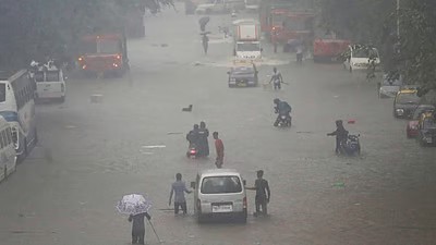
He also added that Ramanathapuram might get some rain and even other districts like Thoothukudi and Nellai had good chance of rainfall on Thursday. On Tuesday, Atiramapattinam received rainfall of 128 mm and Coimbatore received about 48.4 mm of rain. Chennai to receive light rains, good showers over Interior Tamil Nadu Chennai rains have not been disappointing for the residents of the capital city during the month of August. Almost ten days have passed by and the city has been receiving rains of light to moderate intensity. In fact, isolated heavy rainy spells were also witnessed during this period.
However, during the last 24 hours, rainfall activity remained almost absent from the region. In fact, instead of the coastal areas, the interior parts of Tamil Nadu did record a few good spells of rainfall during the last 24 hours. Not only this, a city or two even recorded a whopping three-digit rainfall as well.
In a span of 24 hours from 8:30 am on Tuesday, Atiramapattinam witnessed a whopping 128 mm of rainfall followed by Coimbatore where 48.4 mm of rain was recorded. Other areas to have witnessed light to moderate showers include Madurai 30 mm, Tiruchirapalli 12.8 mm, Palayankottai 8 mm, Coonoor 4.8 mm, and Kodaikanal 2.8 mm.
These weather conditions have been attributed to the trough which is running from the cyclonic circulation over central parts of the country up to Interior Tamil Nadu.
Thus, as per weathermen at Skymet Weather, light to moderate showers with isolated heavy spells will continue over interior areas of Tamil Nadu. Meanwhile, Chennai will only be able to record a few light rainy spells.

Tamil Nadu is the southernmost state of India. The tenth largest Indian state by area and the sixth largest by population, it is the home of the Tamils. In the heart of South India lies Tamil Nadu, a tempting destination for travelers with its diverse blend of vibrant culture, rich history, and breathtaking.
After a brief period of stagnant and weak monsoonal activity across India due to a developing El Niño, the monsoon has intensified significantly in the region. An active upper-air circulation and a trough system are currently driving widespread precipitation across the state. Heavy rain likely in 10 Tamil Nadu districts as Southwest Monsoon set to strength then IMD predicts showers in Western Ghats districts from June 21, with temperatures likely to drop by 4-5 degrees.

CHENNAI: As the upper air circulation and trough area persists, heavy rain is expected to occur in more than ten districts around the Western Ghats area of Tamil Nadu from June 21.
The latest weather bulletin from the Regional Meteorological Centre on Saturday said that a significant shift in weather patterns was expected from Sunday, paving the way for the onset of the Southwest Monsoon.
Accordingly, heavy rain is likely at isolated places over the Nilgiris, Erode, Salem, Dharmapuri, Krishnagiri, Coimbatore, Theni, Dindigul, and Kanyakumari districts, and the ghat areas of Tirunelveli district.
The data further added that due to heavy rain, maximum temperatures are also expected to fall by four to five degrees Celsius over several rain-predicted districts in Tamil Nadu.
Kalasapakkam in Tiruvannamalai district received maximum rainfall of nine cm during the last 24 hours ending at 8.30 am on Saturday, followed by Kakkudi in Ramanathapuram that recorded eight cm of rain during the same period.
Fishermen were warned that squally winds with speeds ranging from 40 to 50 kmph are expected along the Tamil Nadu coast, the Gulf of Mannar, and the adjoining Comorin area.
Meanwhile, Chennai and its suburban areas are expected to get some respite from the heat, with light to moderate evening showers accompanied by thunder and lightning in isolated places.
Current Weather Alerts & Forecasts
Southwest monsoon intensifies; heavy rain expected in over 10 districts of Tamil Nadu Chennai and its suburban areas are expected to get some respite from the heat, with light to moderate evening showers accompanied by thunder and lightning in isolated places.
The latest weather bulletin from the Regional Meteorological Centre on Saturday said that a significant shift in weather patterns was expected from Sunday, paving the way for the onset of the Southwest Monsoon. Accordingly, heavy rain is likely at is likely at isolated places over the Nilgiris, Erode, Salem, Dharmapuri, Krishnagiri, Coimbatore, Theni, Dindigul, and Kanyakumari districts, and the ghat areas of Tirunelveli district. The data further added that due to heavy rain, maximum temperatures are also expected to fall by four to five degrees Celsius over several rain-predicted districts in Tamil Nadu. Kalasapakkam in Tiruvannamalai district received maximum rainfall of nine cm during the last 24 hours ending at 8.30 am on Saturday, followed by Kakkudi in Ramanathapuram that recorded eight cm of rain during the same period. Fishermen were warned that squally winds with speeds ranging from 40 to 50 kmph are expected along the Tamil Nadu coast, the Gulf of Mannar, and the adjoining Comorin area. Meanwhile, Chennai and its suburban areas are expected to get some respite from the heat, with light to moderate evening showers accompanied by thunder and lightning in isolated places.
Heavy Rainfall Warnings: Heavy to very heavy rain is actively occurring or forecasted across more than ten districts. The heaviest downpours are heavily concentrated around the Western Ghats. Tamil Nadu monsoon 2026: Will Chennai, 9 other districts get rain, thunderstorms soon? Details here
According to the Regional Meteorological Centre (RMC), Chennai, weather systems, including an upper-air circulation and a trough, continue to influence conditions over southern India, creating favourable conditions for enhanced rainfall activity.

Chennai is set to witness a significant change in weather conditions from June 21 as the Southwest Monsoon strengthens over Tamil Nadu, bringing widespread rainfall and relief from the prevailing heat across several parts of the state.
According to the IMD’s Regional Meteorological Centre (RMC), Chennai, weather systems, including an upper-air circulation and a trough, continue to influence conditions over southern India, creating favourable conditions for enhanced rainfall activity. The weather office has forecast heavy rain in isolated places in more than ten districts, particularly along the Western Ghats region.
Impacted Districts: The primary districts under heavy rainfall alerts include The Nilgiris, Coimbatore, Erode, Salem, Dharmapuri, Krishnagiri, Theni, Dindigul, Kanyakumari, and the hilly terrains of Tirunelveli.
Chennai & Suburbs: The state capital is experiencing a break from intense summer heat with scattered light to moderate evening showers. These are accompanied by local thunderstorms and lightning.
Temperature Drop: Due to the monsoon strengthening, maximum temperatures across the rain-predicted regions are dropping by 4 to 5 degrees Celsius, offering major relief from previous heatwaves.
Wind Conditions: Isolated areas are expected to witness thunderstorms with gusty monsoonal surface winds reaching speeds of 40–50 km/h.
Advance of Southwest Monsoon 2026 (Annexure I):
❖ The Northern Limit of Monsoon continues to pass through 18°N/60°E, 18°N/65°E, 18°N/70°E, Harnai, Solapur, Hyderabad, Bhadrachalam, Koraput, Phulbani, Ranchi, Jamui, Muzaffarpur and 28.3°N/83°E.
❖ Conditions are favourable for further advance of southwest monsoon into some more parts of Maharashtra, Telangana, Odisha, Jharkhand & Bihar, and some parts of Chhattisgarh around 23rd June, 2026.
Realised weather during past 24 hours ending at 0830 hours IST of today, the 19th June, 2026:
❖ Very Heavy rainfall (12-20 cm) has been recorded at isolated places over Assam & Meghalaya, Gangetic West Bengal, Sub-Himalaya West Bengal & Sikkim.
❖ Heavy rainfall (7-11 cm) has been recorded at isolated places over Arunachal Pradesh, Odisha, Jharkhand.
❖ Heat wave conditions prevailed over East Uttar Pradesh, Bihar and Vidarbha.
❖ Thunderstorm accompanied with Squally/Gusty winds with speed reaching 50-80 kmph has been recorded at isolated places over Gangetic West Bengal, East Uttar Pradesh, Chhattisgarh, Saurashtra & Kutch.
❖ Thunderstorm accompanied with Squally/Gusty winds with speed reaching 30-50 kmph has been recorded at isolated places over Assam & Meghalaya, Nagaland, Manipur, Mizoram & Tripura, Odisha, Bihar, Uttarakhand, West Uttar Pradesh, West Madhya Pradesh, East Madhya Pradesh, Vidarbha, Konkan & Goa, Madhya Maharashtra,Marathwada, Gujarat Region. Temperature Conditions during past 24 hours till 0830 hours IST of today:
❖ Day/Maximum Temperatures (as on 19-06-2026): Yesterday, Day/Maximum temperatures are in the range of 40-42°C over a few places over Uttar Pradesh, East Madhya Pradesh, Vidarbha; at isolated places over Telangana, Bihar, Gujarat, Haryana, Jharkhand, Jharkhand, West Madhya Pradesh and below 40°C over rest parts of the country. The highest maximum temperature of 44.2°C was reported at BANDA (UTTAR PRADESH).
❖ Day/Maximum Temperature Departures (as on 19-06-2026): were in the range of 3-6°C over most parts of Maharashtra adjoining Madhya Pradesh, North Interior Karnataka, Telangana, Goa, East Uttar Pradesh & adjoining Bihar; normal/below normal many parts of over northwest India and Gangetic West Bengal.
❖ Night Temperatures/Minimum temperatures (as on 20-06-2026): markedly above normal (> 5.1°C) at few places over East Madhya Pradesh; at isolated places over Assam & Meghalaya, Nagaland, Manipur, Mizoram & Tripura, Bihar, East Uttar Pradesh, West Uttar Pradesh, Himachal Pradesh, West Rajasthan, West Madhya Pradesh, Gujarat Region, Saurashtra & Kutch, Marathwada and Vidarbha. appreciably above normal (3.1°C to 5.0°C) at few places over Sub Himalayan West Bengal & Sikkim, Odisha, Marathwada, Telangana, Rayalaseema and North Interior Karnataka; atisolated places over Assam & Meghalaya, East Uttar Pradesh, West Uttar Pradesh, East Rajasthan, West Madhya Pradesh, East Madhya Pradesh, Konkan & Goa, Madhya Maharashtra, Vidarbha and Coastal Andhra Pradesh & Yanam. Above normal(1.6°C to 3.0°C) at few places over Andaman & Nicobar Islands, East Uttar Pradesh, East Madhya Pradesh, Gujarat Region, Konkan & Goa, Vidarbha and Chhattisgarh; at isolated places over Sub Himalayan West Bengal & Sikkim, Jharkhand, Bihar, West Uttar Pradesh, Haryana-Chandigarh-Delhi, West Rajasthan, East Rajasthan, West Madhya Pradesh, Saurashtra & Kutch, Madhya Maharashtra, Marathwada, Coastal Andhra Pradesh & Yanam, Telangana, Rayalaseema, Tamil Nadu, Puducherry & Karaikal, South Interior Karnataka and Kerala & Mahe. near normal/ below normal over rest parts of the country.
Weather Systems, Forecast and Warnings (Annexure II & III):
❖ A seasonal trough runs from Punjab to Bihar in lower tropospheric level.
❖ A western Disturbance as a cyclonic circulation over north Punjab & neighbourhood in lower & middle tropospheric levels with a trough aloft in middle & upper tropospheric westerlies runs roughly along Long 70°E to the north of Lat 30°N.
❖ An upper air cyclonic circulation lies over East Uttar Pradesh & neighbourhood in lower tropospheric level.
❖ A trough runs from the above cyclonic circulation over East Uttar Pradesh to Coastal Andhra Pradesh in lower tropospheric level.
❖ A trough in lower tropospheric westerlies with its axis at 1.5 km above mean sea level runs roughly along Long. 87 °E to the north of Lat.21°N.
❖ An upper air cyclonic circulation lies over Gujarat & neighbourhood in middle tropospheric level.
❖ A trough runs from North Telangana to East Central Arabian Sea in middle tropospheric level.
❖ An upper air cyclonic circulation lies over north Kerala in middle tropospheric level.
❖ An upper air cyclonic circulation lies over north Lakshadweep & neighbourhood in lower tropospheric level.
Under the influence of above systems, the following weather is likely:
Northwest India:
❖ Fairly Widespread to Widespread rainfall likely over Jammu-Kashmir-Ladakh-Gilgit-Baltistan-Muzaffarabad during 20th-22nd June.
❖ Isolated to Scattered rainfall likely over Jammu-Kashmir-Ladakh-Gilgit-Baltistan-Muzaffarabad during 23rd-26th June; Himachal Pradesh and Uttarakhand during 20th-26th June.
❖ Isolated to Scattered rainfall likely over Haryana Chandigarh & Delhi and Punjab during 20th-23rd June; West Uttar Pradesh on 20th June and on 26th June; East Uttar Pradesh during 25th-26th June; West Rajasthan during 20th-24th June; East Rajasthan during 20th-26th June.
❖ Isolated thunderstorm, lightning & gusty winds (speed reaching 40-50 kmph gusting to 60 kmph) likely over Jammu-Kashmir-Ladakh-Gilgit-Baltistan-Muzaffarabad and Uttarakhand during 20th-22nd June, with gusty winds (speed reaching 30-40 kmph gusting to 50 kmph) likely over Himachal Pradesh during 20th-22nd June.
❖ Isolated thunderstorm, lightning & gusty winds (speed reaching 40-50 kmph gusting to 60 kmph) likely over Haryana Chandigarh & Delhi and Punjab during 20th-23rd June; East Rajasthan and West Rajasthan during 21st-23rd June, with gusty winds (speed reaching 30-40 kmph gusting to 50 kmph) likely over West Rajasthan on 24th June;
East Rajasthan during 24th-26th June.
❖ Thundersquall (wind speed reaching 50-60 kmph gusting to 70 kmph) likely over East Rajasthan and West Rajasthan on 20th June.
❖ Isolated Hailstorm activity likely over Jammu-Kashmir-Ladakh-Gilgit-Baltistan-Muzaffarabad during 20th-21st June.
Central India:
❖ Isolated to Scattered rainfall likely over Chhattisgarh, East Madhya Pradesh, Vidarbha and West Madhya Pradesh during 20th-26th June.
❖ Isolated thunderstorm, lightning & gusty winds (speed reaching 40-50 kmph gusting to 60 kmph) likely over West Madhya Pradesh during 21st-24th June; East Madhya Pradesh and Vidarbha during 20th-24th June; Chhattisgarh during 20th-26th June.
❖ Thundersquall (wind speed reaching 50-60 kmph gusting to 70 kmph) likely over West Madhya Pradesh on 20th June.
East India:
❖ Fairly Widespread to Widespread rainfall likely over Andaman & Nicobar Islands and Sub-Himalayan West Bengal & Sikkim during 20th-26th June; Gangetic West Bengal during 20th-25th June; Odisha during 20th-21st June.
❖ Isolated to Scattered rainfall likely over Gangetic West Bengal on 26th June; Bihar and Jharkhand during 20th-26th June; Odisha during 22nd-26th June.
❖ Isolated thunderstorm, lightning & gusty winds (speed reaching 40-50 kmph gusting to 60 kmph) likely over Andaman & Nicobar Islands during 20th-26th June; Sub-Himalayan West Bengal & Sikkim on 20th June; Gangetic West Bengal during 20th-21st June; Jharkhand during 22nd-26th June; Bihar during 20th-22nd June and during 25th-26th June; Odisha during 22nd-24th June, with gusty winds (speed reaching 30-40 kmph gusting to 50 kmph) likely over Sub-Himalayan West Bengal & Sikkim during 21st-26th June; Gangetic West Bengal during 22nd-26th June; Bihar during 23rd-24th June.
❖ Isolated heavy rainfall likely over Sub-Himalayan West Bengal & Sikkim during 20th-21st June and during 23rd-25th June; Gangetic West Bengal on 20th June; Bihar during 20th-21st June and during 25th-26th June;
Odisha during 20th-21st June with isolated very heavy rainfall also likely over Sub-Himalayan West Bengal & Sikkim on 22nd June and on 26th June with isolated Extremely heavy rainfall also likely Sub-Himalayan West Bengal & Sikkim during 20th-21st June.
❖ Thundersquall (wind speed reaching 50-60 kmph gusting to 70 kmph) likely over Jharkhand and Odisha during 20th-21st June.
Northeast India:
❖ Fairly Widespread to Widespread rainfall likely over Arunachal Pradesh, Assam & Meghalaya and Nagaland, Manipur, Mizoram & Tripura during 20th-26th June.
❖ Isolated heavy rainfall likely over Arunachal Pradesh during 20th-24th June; Assam & Meghalaya during 23rd-26th June; Nagaland, Manipur, Mizoram & Tripura during 20th-23rd June with isolated very heavy rainfall also likely over Assam & Meghalaya during 20th-22nd June.
West India:
❖ Isolated to Scattered rainfall likely over Konkan & Goa during 20th-21st June and on 26th June; Gujarat Region, Madhya Maharashtra, Marathawada and Saurashtra & Kutch during 20th-26th June.
❖ Fairly Widespread to Widespread rainfall likely over Konkan & Goa during 22nd-25th June.
❖ Isolated thunderstorm, lightning & gusty winds (speed reaching 40-50 kmph gusting to 60 kmph) likely over Konkan & Goa during 21st-24th June; Madhya Maharashtra during 22nd-26th June; Marathawada on 20th June and during 23rd-24th June; Gujarat Region and Saurashtra & Kutch on 20th June.
❖ Isolated heavy rainfall likely over Konkan & Goa during 23rd-24th June.
South Peninsular India:
❖ Isolated to Scattered rainfall likely over Tamil Nadu, Puducherry & Karaikal during 20th-26th June; Coastal Karnataka on 20th June; North Interior Karnataka during 20th-21st June and during 23rd-24th June; Coastal Andhra Pradesh & Yanam and South Interior Karnataka during 20th-23rd June; Rayalaseema during 20th-24th June; Telangana during 20th-21st June.
❖ Fairly Widespread to Widespread rainfall likely over Kerala & Mahe and Lakshadweep during 20th-26th June; Coastal Karnataka during 21st-26th June; North Interior Karnataka on 22nd June and during 25th-26th June; Coastal Andhra Pradesh & Yanam and South Interior Karnataka during 24th-26th June; Rayalaseema during 25th-26th June; Telangana during 22nd-26th June.
❖ Isolated thunderstorm, lightning & gusty winds (speed reaching 40-50 kmph gusting to 60 kmph) likely over Kerala & Mahe, Lakshadweep and Tamil Nadu, Puducherry & Karaikal during 20th-22nd June; Coastal Andhra Pradesh & Yanam and Rayalaseema during 21st-24th June; Telangana during 20th-24th June, with gusty winds (speed reaching 30-40 kmph gusting to 50 kmph) likely over North Interior Karnataka during 20th-21st June.
❖ Isolated heavy rainfall likely over Tamil Nadu, Puducherry & Karaikal during 20th-22nd June; Kerala & Mahe during 20th-23rd June and on 26th June; Lakshadweep during 21st-22nd June; Coastal Karnataka during 21st-24th June; North. Interior Karnataka and South Interior Karnataka during 22nd-23rd June; Coastal Andhra Pradesh & Yanam during 25th-26th June; Rayalaseema during 20th-22nd June and during 25th-26th June; Telangana during 22nd-26th June.
❖ Thundersquall (wind speed reaching 50-60 kmph gusting to 70 kmph) likely over Coastal Andhra Pradesh & Yanam and Rayalaseema on 20th June.
Heat Wave, Hot & Humid weather and Warm Night conditions warning:
❖ Heat wave conditions very likely in isolated pockets over Bihar and Telangana during 20th-21st June; East Uttar Pradesh and Vidarbha during 20th-24th June; Konkan & Goa and Madhya Maharashtra on 20th June.
❖ Hot and humid weather conditions likely to prevail over Coastal Karnataka, Jharkhand, Konkan & Goa and North Interior Karnataka during 20th-21st June.
Forecast of maximum/day temperatures:
❖ No significant change in maximum temperatures likely over Northwest India till 22nd June and gradual fall by 2°C during next 2 days and no significant change thereafter.
❖ No significant change in maximum temperatures likely over South peninsular India till 21st
June and gradual fall by 2-5°C thereafter.
❖ No significant change in maximum temperatures likely over Maharashtra till 21th June and gradual fall by 2-3°C thereafter.
❖ No significant change in maximum temperatures likely over the rest parts of country till 25th June, 2026. Fisherman Warning: Fishermen are advised not to venture into the following areas during 20th June to 25th June, 2026:
Bay of Bengal: Over Gulf of Mannar during 21st to 25th June. North & adjoining eastcentral Bay of Bengal 20th to 21st June, central Bay of Bengal during 22nd to 25th June, southwest Bay of Bengal on 24th June, along & off Odisha coast on 20th & 21st June and south coastal Andhra Pradesh on 20th June.
Arabian Sea: Along and off Somalia coast adjoining parts of southwest & westcentral Arabian Sea till 25th June; along & off Oman-Yemen coasts and adjoining parts of northwest & westcentral Arabian Sea during 22nd to 25th June, along & off. Gujarat coast on 20th June, along & off south Konkan, Goa, Karnataka & Kerala coasts, Lakshadweep & adjoining Comorin till 23rd June, along & off Gujarat & Konkan & Karnataka coasts on 24th June and Gujarat & North Konkan coasts on 25th June.
Weather conditions and forecast over Delhi/NCR during 20th June -23nd June, 2026 (Annexure IV)
For more details, kindly refer National Weather Bulletin:
Significant rainfall recorded (in cm) (from 0830 hours IST of yesterday to 0830 hours IST of today):
❖ Sub-Himalayan West Bengal & Sikkim: Bhatkawa Tea Estate (dist Jalpaiguri) 18, Barobhisha (dist Alipurduar) 15, Dima Tea Estate (dist Alipurduar) 15, Raidak Tea Estate (dist Alipurduar) 11, Chepan (dist Alipurduar) 9, Jhallong (dist Kalimpong) 8, Kumargram (dist Alipurduar) 7;
❖ Tamil Nadu & Karaikal: Aavoor (dist Thiruvarur) 14, Ariyalur Taluk Office (dist Ariyalur), Ariyalur PTO (dist Ariyalur), Kumbakonam (dist Thanjavur), Satharasankottai (dist Sivagangai), Perumandi (dist Thanjavur) 11 each, Ariyalur AWS (dist Ariyalur), Mathur (dist Thanjavur), Ilayathangudi (dist Sivagangai) 10 each, Melur ARG (dist Madurai), Ayyalur (dist Dindigul) 9 each, Perambalur (dist Perambalur), Tirumayam (dist Pudukkottai), Thamarakki (dist Sivagangai), Palavidithi (dist Karur) 8 each, Thaniamangalam (dist Madurai), Karaiyur (dist Pudukkottai), Tirupuvanam (dist Sivagangai), Thanjai Papanasam (dist Thanjavur), Sivaganga (dist Sivagangai) 7 each;
❖ Assam & Meghalaya: B P Ghat (dist Sribhumi) 13, Gossaigaon_ Aws (dist Kokrajhar) 12, Gossaigaon (dist Kokrajhar) 11, Karimganj_aws (dist Sribhumi) 11, Karimganj (dist Sribhumi) 7;
❖ Gangetic West Bengal: Uluberia (dist Howrah) 12, Harinkhola (dist Hooghly) 11, Amfu Kharagpur (dist West Midnapore) 11, Amta (dist Howrah) 10, Kalaikunda (Iaf) (dist West Midnapore) 9, Mo Saltlake (dist North 24 Parganas) 9, Barrackpur(Iaf) (dist North 24 Parganas) 7, Burdwan (pto) (dist Purba Bardhaman) 7;
❖ Gujarat Region: Halol (dist Panchmahal) 11, Shahera (dist Panchmahal) 7, Kadi (dist Mehsana) 7;
❖ Odisha: Cuttack (dist Cuttack) 9; Harichandanpur (dist Keonjhargarh), Sarasakana (dist Mayurbhanj) 8 Each; Jaipatna
(dist Kalahandi), Suliapada (dist Mayurbhanj) 7 Each;
❖ Bihar: Rajnagar (dist Madhubani) 8;
❖ Saurashtra & Kutch: Barvala (dist Botad) 7;
❖ Jammu-Kashmir: Reasi Kvk Aws (dist Reasi) 7;
❖ Arunachal Pradesh: Pasighat_ Aero (dist East Siang) 7;
❖ Telangana: Tadwai Mlg (dist Mulugu) 7.
Gusty winds (in >= 40 kmph) (from 0830 hours IST of yesterday to 0830 hours IST of today):
❖ East Uttar Pradesh: Azamgarh (AWS State) – 59; Ambedkar Nagar (AWS State) – 54; Mirzapur (AWS State) – 52;
Mirzapur (AWS) – 44;
❖ Gangetic West Bengal: Hooghly – 56; Shyampur – 46; Alipore – 44; Jagatballavpur – 43
❖ Chhattisgarh: Surajpur – 52; Bemetara – 52; Mungeli – 50; Raipur – 46;
❖ Madhya Maharashtra: Dondaicha (Dhule) – 50; Kalwan (Nashik) – 48
❖ West Madhya Pradesh: Indore – 48
❖ Odisha: Bhubaneswar – 46
❖ Bihar: East Champaran – 46
❖ Uttarakhand: Chamoli – 43;
❖ Vidarbha: Akola – 43
❖ Konkan & Goa: Karjat (Raigad) – 43;
❖ West Uttar Pradesh: Jhansi – 41
❖ East Madhya Pradesh: Rewa – 41 Annexure I Annexure II
- As the lead period increases forecast accuracy decrease. Annexure III • Action may be taken based on ORANGE AND REDCOLOUR warnings.
- Vulnerable regions likely urban and hilly areas action may be initiated for heavy rainfall warning.
- As the lead period increases forecast accuracy decreases.
Past Weather:
There has been no large change in maximum temperatures and rise in minimum temperatures by 1-2°C over Delhi during past 24 hours. The maximum temperatures were found 39-40°C and the minimum temperatures are in the range 26- 29°C respectively during past 24 hours over Delhi. The minimum temperatures are below normal (-1.6°C to -3.0°C) at
isolated places and normal (-1.5°C to 1.5°C) over remaining parts of Delhi. The maximum temperatures were above normal (1.6°C to 3.0°C) at isolated places and normal (-1.5°C to 1.5°C) at remaining places over Delhi. Partly cloudy sky with wind speed 20 kmph gusting to 35 kmph from west-northwest direction prevailed over Delhi during past 24 hours.
Partly cloudy sky with surface wind speeds up to 20 kmph gusting to 36 kmph likely to prevailed from west-southwest direction over the region in the forenoon today.
Weather Forecast:
20.06.2026: Partly cloudy sky. Possibility of a spell of very light to light rain with thunderstorm/lightning and strong winds 40-50 gusting to 60 kmph towards afternoon/evening. The maximum temperatures over Delhi are likely to be in the range of 38°C to 40°C. The maximum temperatures will be near normal (-1.5°C to 1.5°C) at most places over Delhi.
The predominant surface wind is likely to be from the west direction with surface wind speed reaching up to 20 kmph during the afternoon hours. The wind speed will decrease becoming up to 15 kmph from the west direction during evening and night.
21.06.2026: Partly cloudy sky. A spell of very light/light rain with thunderstorm/lightning/dust storm and strong winds 40-50 gusting to 60 kmph towards afternoon/evening. The maximum and minimum temperatures over Delhi are likely to be in the range of 38°C to 40°C and 27°C to 29°C, respectively. The minimum temperature will be near normal (-1.5°C to 1.5°C) at most places and maximum temperatures will be near normal (-1.5°C to 1.5°C) at most places over Delhi. The
predominant surface wind is likely to be from west direction with surface wind speed reaching up to 20 kmph during the morning hours. The wind speed will decrease becoming up to 15 kmph from northwest direction during the afternoon. The wind speed will decrease becoming up to 12 kmph from the northwest direction during evening and night.
22.06.2026: Partly cloudy sky. A spell of very light/light rain with thunderstorm/lightning/dust storm and strong winds 40-50 gusting to 60 kmph towards afternoon/evening. The maximum and minimum temperatures over Delhi are likely to be in the range of 36°C to 38°C and 26°C to 28°C, respectively. The minimum temperature will be near normal (-1.5°C to 1.5°C) at most places, and maximum temperatures will be near normal (-1.5°C to 1.5°C) at most places over Delhi. The predominant surface wind is likely to be from the northwest direction with wind reaching up to 18 kmph during the morning hours. The wind speed will increase becoming up to 20 kmph from northwest direction during the afternoon. The wind speed will increase becoming up to 25 kmph from the west direction during evening and night.
23.06.2026: Partly cloudy sky. - The maximum and minimum temperatures over Delhi are likely to be in the range of 36°C to 38°C and 26°C to 28°C, respectively. The minimum temperature will be near normal (-1.5°C to 1.5°C) at most places, and maximum temperatures will be near normal (-1.5°C to 1.5°C) at most places over Delhi. The predominant surface wind is likely to be from the west direction with wind reaching up to 25 kmph during the morning hours. The surface wind speed will decrease becoming up to 20 kmph from west direction during the afternoon. The wind speed will decrease becoming up to 15 kmph from the west direction during evening and night.
Impact expected and Action Suggested due to thunderstorm with lightning/gusty winds:
Thunderstorms accompanied with lightning and gusty winds (40–50 kmph reaching up to 60 kmph) with dust-raising surface winds are likely to occur. - Expected Impacts: Breaking of tree branches and uprooting of large trees, falling of dead tree limbs, Damage to standing crops, Minor to major damage to power and communication lines due to falling branches, Partial damage to vulnerable structures due to strong winds, Loose objects may get blown away.
- Advisory for Public Safety: Keep a close watch on weather updates and worsening conditions, stay indoors and avoid unnecessary travel, Close windows and doors securely, take shelter in safe places and avoid open areas, do not take shelter under trees, do not lie on concrete floors or lean against concrete walls during lightning activity, unplug electrical and electronic appliances, immediately move out of water bodies, stay away from objects that conduct electricity
Citizens are advised to remain alert and follow safety precautions to avoid any loss of life or property. Impact expected and action suggested due to isolated thunderstorm with lightning, gusty/squally winds & hailstorm over
❖ Moderate to severe thunderstorm activity likely over Central and East India today.
Impact expected:
➢ Breaking of tree branches, uprooting of large avenue trees. Large dead limbs blown from trees. Damage to Standing crops.
➢ Minor to Major damage to banana and papaya trees.
➢ Minor to major damage to power and communication lines due to breaking of branches.
➢ Strong wind/hail may damage plantation, horticulture and standing crops.
➢ Partial damage to vulnerable structures due to strong winds.
➢ Minor damage to kutcha houses/walls and huts.
➢ Loose objects may fly.
Action suggested:
➢ People are advised to keep a watch on the weather for worsening conditions and be ready to move to safer places accordingly.
➢ Stay indoors, close windows & doors and avoid travel if possible.
➢ Take safe shelters; do not take shelter under trees.
➢ Do not lie on concrete floors and do not lean against concrete walls.
➢ Unplug electrical/ electronic appliances.
➢ Immediately get out of water bodies.
➢ Keep away from all the objects that conduct electricity.
Impact Expected & Action Suggested due to heavy/very heavy/ Extremely rainfall over
❖ Isolated heavy to very heavy rainfall over northeast adjoining east India during next 4-5 days.
❖ Isolated Extremely heavy rainfall also likely Sub-Himalayan West Bengal & Sikkim during 20th-21st June.
Impact Expected
➢ Localized Flooding of roads, water logging in low lying areas and closure of underpasses mainly in urban areas.
➢ Occasional reduction in visibility due to heavy rainfall.
➢ Disruption of traffic in major cities due to water logging in roads leading to increased travel time.
➢ Minor damage to kutcha roads.
➢ Possibilities of damage to vulnerable structure.
➢ Localized Landslides/Mudslides/landslips/mudslips/landsinks/mudsinks.
➢ Damage to horticulture and standing crops in some areas due to inundation.
➢ It may lead to riverine flooding in some river catchments (for riverine flooding please visit Web page of CWC)
Action Suggested
➢ Check for traffic congestion on your route before leaving for your destination.
➢ Follow any traffic advisories that are issued in this regard.
➢ Avoid going to areas that face the water logging problems often.
➢ Avoid staying in vulnerable structure.
Impact expected and action suggested due to Heat wave conditions:
❖ Heat wave conditions very likely in isolated pockets over Bihar and Telangana during 20th-21st June; East Uttar Pradesh and Vidarbha during 20th-24th June; Konkan & Goa and Madhya Maharashtra on 20th June.
Alert Areas
➢ High temperature & increased likelihood of heat illness symptoms in people who are either exposed to sun for a prolonged period or doing heavy work.
➢ High health concern for vulnerable people e.g. infants, elderly, people with chronic diseases.
➢ Avoid heat exposure– keep cool. Avoid dehydration.
➢ Drink sufficient water- even if not thirsty. ➢ Use ORS, homemade drinks like lassi, torani (rice water), lemon water, buttermilk, etc. to keep yourself hydrated.
Agromet advisories for likely impact of Hailstorms
➢ In Jammu & Kashamir, use hail nets or hail caps in fruit orchards and vegetable plants to protect them from mechanical damage. Ensure effective field drainage to prevent waterlogging. Undertake picking of matured fruits at the earliest. Keep the harvested produce in safe places.
Agromet advisories for likely impact of Heavy Rainfall
➢ In Arunachal Pradesh, ensure proper drainage in vegetables, maize, rice nursery and other crop fields to prevent waterlogging. Harvest mature vegetables and fruits to avoid crop losses.
➢ In Assam, ensure proper drainage arrangements for quick removal of excess water from rice nurseries, jute, ginger, turmeric, vegetables, banana, citrus and papaya. Avoid nursery sowing of Sali rice during heavy rainfall. Cover the rice nursery beds with thin polythene sheet. Provide mechanical support to the sugarcane crop to prevent lodging.
➢ In Meghalaya, ensure proper drainage channels in rice nurseries, maize, ginger, cowpea, vegetable fields and banana plantations. Protect young seedlings from direct exposure to heavy rainfall. Use propping (bamboo or wooden poles) to support heavily laden plants.
➢ In Manipur, avoid transplanting of rice during heavy rainfall. Ensure proper drainage in soybean, chilli, ginger, turmeric, banana and other crop fields and newly transplanted seedlings and nursery crops to avoid waterstagnation.
➢ In Tripura, ensure adequate drainage arrangements to remove excess water from rice and vegetable fields during heavy rainfall.
➢ In Sub Himalayan West Bengal, avoid nursery sowing of rice during heavy rainfall; protect already sown rice nursery beds with straw mulch, dry grass, or temporary polythene / agro-net covers to prevent seed washing, poor germination and seedling loss. Drain out excess water from jute, ginger, chilli, tomato and dalley khorsani fields and nurseries of kharif rice and vegetables.
➢ In Gangetic West Bengal, cover harvested rice produce with tarpaulin during rainfall or shift harvested crop to a safe area. Provide proper field drainage in rice nurseries, jute, aman rice and vegetable fields to avoid waterlogging. Provide adequate staking and support to sesame and other susceptible crops to prevent lodging.
➢ In Keralam, drain out excess water from banana, coconut, cardamom, ginger, black pepper and vegetables. Provide staking support in banana plants and strengthen the pandals of vegetable crops. Avoid transplanting of rice during heavy rain.
➢ In Tamil Nadu, maintain proper drainage in rice, cumbu, groundnut, sugarcane, banana and vegetables. Keep the harvested produce at safe places.
➢ In Coastal Karnataka, ensure proper drainage in rice seedbeds to prevent water stagnation.
Agromet advisories for likely impact of High temperatures / Heat Waves
➢ In Bihar, East Uttar Pradesh, Vidarbha and Telangana, apply light irrigation as per requirement in vegetable
crops and fruit orchards. Carry out mulching with crop residue, straw or polythene to conserve soil moisture. Use temporary shade nets to protect the fruit plants from high temperatures.
Agromet advisories for likely impact of Thunderstorm / Gusty Winds
➢ Shift the harvested produce in safer places or cover the produce with tarpaulin sheets in the fields. Tie the harvested crops securely and cover them to minimize the risk of displacement from strong surface winds.
➢ Provide mechanical support to horticultural crops and staking or support to vegetables and young fruit plants / fruit-bearing plants to avoid lodging due to strong winds.
Livestock / Poultry / Fisheries
➢ Keep the animals inside the shed during heavy rainfall and provide them balanced feed.
➢ Store the feed and fodder in a safe place to prevent spoilage.
➢ In regions with high temperatures and heat wave conditions, provide clean, cool drinking water to animals, and cover the roofs of poultry sheds with grass to reduce the adverse effects of heat.
➢ Construct an outlet with proper netting around the ponds to drain excess water, thereby preventing fish from
escaping in the event of overflow. Legends & abbreviations:
❖ Heavy Rain:64.5115.5mm; Very Heavy Rain:115.6204.4mm; Extremely Heavy Rain: >204.4mm.
❖ Obsy: Observatory; Automatic Weather Station; ARG: Automatic Rain Gauge; dist: District: NH: National Highway;
KVK: Krishi Vigyan Kendra; DVC: Damodar Valley Corporation; PTO: Part Time Office, Aero: Aerodrome, IAF: Indian Air Force.
❖ Region wise classification of meteorological Sub-Divisions: - Northwest India: Western Himalayan Region (Jammu-Kashmir-Ladakh-Gilgit-Baltistan-Muzaffarabad,
Himachal Pradesh and Uttarakhand); Punjab, Haryana Chandigarh & Delhi; West Uttar Pradesh, East UttarPradesh, West Rajasthan and East Rajasthan. - Central India: West Madhya Pradesh, East Madhya Pradesh, Vidarbha and Chhattisgarh.
- East India: Bihar, Jharkhand, Sub-Himalayan West Bengal & Sikkim; Gangetic West Bengal, Odisha and Andaman & Nicobar Islands.
- Northeast India: Arunachal Pradesh, Assam & Meghalaya and Nagaland, Manipur, Mizoram & Tripura.
- West India: Gujarat Region, Saurashtra & Kutch, Coastal Maharashtra (Konkan) & Goa, Madhya Maharashtra and Marathawada.
- South India: Coastal Andhra Pradesh & Yanam, Telangana, Rayalaseema, Coastal Karnataka, North Interior Karnataka, South Interior Karnataka, Kerala & Mahe, Tamil Nadu, Puducherry & Karaikal and Lakshadweep.
Seasonal Overview & Agriculture Outlook
District level seasonal rainfall forecast for Southwest Monsoon, 2026. Southwest monsoon season (June to September) – 2026 rainfall forecast for different districts of Tamil Nadu is developed based on the Southern Oscillation Index and Sea Surface Temperature values of Pacific and Indian Oceans by using Australian Rainman International V.4.3. Software at Agro Climate Research Centre of Tamil Nadu Agricultural University, Coimbatore and is presented at 60% probability level. The districts of Tamil Nadu based on the predicted rainfall have been grouped hereunder. Normal Rainfall (±10 per cent deviation from long term rainfall) is expected in most of the districts in Tamil Nadu. Near Normal Rainfall(-10 per cent deviation from the long term rainfall) is expected in Coimbatore, Erode, Tiruppur, Dindigul and Theni districts of Tamil Nadu.
District level seasonal rainfall forecast for Southwest Monsoon 2026
S. No Districts Normal Rainfall (mm) Predicted Rainfall
(mm) Per cent deviation
North Eastern Zone
1 Chennai 440 430 -2
2 Chengalpattu 450 438 -3
3 Cuddalore 360 360 0
4 Kallakurichi 410 384 -6
5 Kancheepuram 479 458 -4
6 Ranipet 450 426 -5
7 Tiruvallur 456 440 -4
8 Tirupathur 416 398 -4
9 Thiruvannamalai 449 419 -7
10 Villupuram 405 372 -8
11 Vellore 453 453 0
Western Zone
12 Coimbatore 210 178 -15
13 Erode 260 231 -11
14 Tiruppur 151 129 -15
North Western Zone
15 Dharmapuri 392 359 -8
16 Krishnagiri 375 377 1
17 Namakkal 336 300 -11
18 Salem 421 410 -3
Cauvery Delta Zone
19 Ariyalur 377 338 -10
20 Karur 199 190 -5
21 Mayiladuthurai 295 274 -7
22 Nagapattinam 279 258 -8
23 Perambalur 279 263 -6
24 Thanjavur 314 296 -6
25 Tiruvarur 302 281 -7
26 Tiruchirapalli 277 268 -3
Southern Zone
27 Dindigul 308 272 -12
28 Madurai 325 302 -7
29 Pudukkottai 330 323 -2
30 Ramanathapuram 135 124 -8
31 Sivaganga 417 385 -8
32 Theni 215 192 -11
33 Tenkasi 175 159 -9
34 Tuticorin 67 61 –9
35 Tirunelveli 128 108 -16
36 Virudhunagar 190 176 -7
Hilly Zone
37 The Nilgiris 875 823 -6
High Rainfall
38 Kanyakumari 491 478 -3 jkpH;ehl;oy; 2026-k; tUlj]jpw]fhd bjd;nkw;Fg] gUtkiH Kd;dwptpg;g[
vjph;tuf;Toa 2026-k; Mz;od; bjd;nkw;Fg] gUtkiHf; fhyj;jpw;fhd ($%d; khjk; Kjy;
brg;lk;gh; khjk; tiu) kiH gw;wpa Kd;dwptpg;g[ bra;tjw;fhf jkpH;ehL ntshz;ik
gy;fiyf;fHfj;jpYs;s ntshz; fhyepiy Muha;r;rp ikak;/ gaph; nkyhz;ik ,af;fj;jpy; Ma;t[
nkw;bfhs;sg;gl;lJ. ,jw;fhf khh;r;; kw;Wk; Vg;uy; khj’;fspy; grpgpf; bgU’;flypy; g{kj;jpanuifia
xl;oa[s;s flw;gFjpapd; nkw;gug;g[ ePhpd; btg;gepiy kw;Wk; bjd; kz;ly fhw;wGj;j FwpaPL
Mfpatw;iw cgnahfpj;J M!;jpnuypa ehl;oypUe;J bgwg;gl;l kiH kdpjd; (Australian Rainman
International V.4.3 Software) vd;Dk; fzpzp fl;likg;igf; bfhz;L 2025-k; Mz;ow]fhd
bjd;nkw;Fg; gUtkiH Kd;dwptpg;g[ bgwg;gl;lJ. jkpHfj;jpd; gy;ntW khtl;l’;fspy; 60 rjtpfpj
tha;g;gpw]fhd vjph;ghh;f;fg;gLk; kiHast[ fPnH jug;gl;Ls;sJ.
nfhak;g[j;J}h;/ <nuhL/ jpUg;g[{h;/ jpz;Lf;fy; kw;Wk; njdp khtl;l’;fspy; ruhrhpf;F xl;oa
kiHa[k;/ kw;w khtl;l’;fspy; ruhrhp kiHast[k; vjph;ghh;f;fg;gLfpwJ.
ntshz; fhyepiy Muha;r;rp ikak;
jkpH;ehL ntshz;ikg; gy;fiyf;fHfk;
nfhaKj;J}}h; – 641 003. jkpH;ehl;od: bjd;nkw;F gUtkiH Kd]dwptpg]g[ – 2026
t. vz; khtl]lk;
ruhrhp kiHast[
(kp.kP)
vjph]ghh]f]fg]gLk]
kiHast[[
(kp.kP) rjtpfpj ntWghL
(%)
tlfpHf;F ntshz; fhyepiy kz;lyk;
1 brd;id 440 430 -2
2 br’;fy;gl;L 450 438 -3
3 flY}h; 360 360 0
4 fs;sf;Fwpr;rp 410 384 -6
5 fh”;rpg[uk; 479 458 -4
6 ,uhzpngl;il 450 426 -5
7 jpUts;~h; 456 440 -4
8 jpUg;gj;J}h; 416 398 -4
9 jpUtz;zhkiy 449 419 -7
10 tpGg;g[uk; 405 372 -8
11 ntY}h; 453 453 0
nkw;F ntshz; fhyepiy kz;lyk;
12 nfhaKj;J}h; 210 178 -15
13 <nuhL 260 231 -11
14 jpUg;g{h; 151 129 -15
tlnkw;F ntshz; fhyepiy kz;lyk;
15 jh;kg[hp 392 359 -8
16 fpU#;zfphp 375 377 1
17 ehkf;fy; 336 300 -11
18 nryk; 421 410 -3
fhtphp ntshz; fhyepiy kz;lyk;
19 mhpaY}h; 377 338 -10
20 f+h; 199 190 -5
21 kapyhLJiw 295 274 -7
22 ehfgl;ozk; 279 258 -8
23 bguk;gY}h; 279 263 -6
24 j”;rht[{h; 314 296 -6
25 jpUth+h; 302 281 -7
26 jpUr;rpuhg;gs;sp 277 268 -3
bjw;F ntshz; fhyepiy kz;lyk
27 jpz;Lf;fy; 308 272 -12
28 kJiu 325 302 -7
29 g[Jf;nfhl;il 330 323 -2
30 ,uhkehjg[uk; 135 124 -8
31 rptf’;if 417 385 -8
32 njdp 215 192 -11
33 bjd;fhrp 175 159 -9
34 J}j;Jf;Fo 67 61 –9
35 jpUbey;ntyp 128 108 -16
36 tpUJefh; 190 176 -7
kiyg;gpnunjr kz;lyk;
37 ePyfphp 875 823 -6
mjpf kiH bgWk; kz;lyk;
38 fd;dpahFkhp 491 478 -3
- Deficit Risk Areas: A few specific western and southern districts—including Coimbatore, Erode, Tiruppur, Dindigul, and Theni—are modeled to skew slightly lower, receiving near-normal rainfall around a -10% deviation.
- The El Niño Factor: While the country-wide monsoon volume is projected to drop to roughly 90% of its Long Period Average (LPA) due to shifting equatorial Pacific conditions, Tamil Nadu relies primarily on the North-East Monsoon (October–December) for its maximum annual rainfall. The current Southwest Monsoon serves as a vital secondary source, primarily fueling early-season crop cultivation along the Western Ghats and delta districts.
Heavy Rain Alert ZonesYellow
Moderate Showers
Deep Dive & Analysis
To understand how these shifting monsoon models impact broader regional sectors, consider exploring the following detailed analyses:
Monsoon Data & Agriculture Updates