Back-to-back western disturbances are expected to bring dust storms, thunderstorms and rain across north India over the next few days. The change could push temperatures below 42°C in some areas, while also causing localised disruption.

After days of relentless heatwave conditions across north India, a series of incoming weather systems may finally bring much-needed relief.
According to the latest meteorological assessments, multiple back-to-back Western Disturbances are set to influence the region over the coming days, potentially lowering temperatures and triggering dust storms and rainfall.
A Western Disturbance is a weather system that originates in the Mediterranean region and travels eastward, bringing moisture and instability to parts of north India. India turns into a hotbox: 95 out of 100 world’s hottest cities today are in India from central India to the Indo-Gangetic plains, temperatures have soared past 40°C in dozens of cities, with several locations inching closer to the 45°C mark.

India is at the epicentre of a global heat surge, with an overwhelming 95 of the world’s 100 hottest cities located in the country today, according to real-time global temperature rankings.
The data from AQI.in taken at 5:00 pm on April 24 highlights the intensity and scale of the ongoing heatwave gripping large parts of the subcontinent.
From central India to the Indo-Gangetic plains, temperatures have soared past 40°C in dozens of cities, with several locations inching closer to the 45°C mark.
A series of back-to-back Western Disturbances (WDs) is forecast to hit North India starting April 27, 2026, bringing a much-needed break to a relentless heatwave that has pushed temperatures as high as 45°C-47°C in regions like Uttar Pradesh.

Western disturbance to hit Himachal Pradesh from April 27; Rain, storms likely till 30
Babushahi Bureau
Shimla (Himachal Pradesh) , April 26, 2026: Weather conditions across Himachal Pradesh are set to change from Monday as a fresh western disturbance becomes active, bringing the likelihood of rain and thunderstorms till April 30.
On Saturday, the state witnessed contrasting weather patterns. Higher reaches, including Rohtang Pass and Kunzum Pass, received fresh snowfall, while areas around Atal Tunnel and Kullu saw rain and gusty winds. In contrast, plains experienced intense heatwave conditions.
The weather is expected to remain clear on Sunday, with temperatures likely to rise further across the state. However, from Monday onwards, changing conditions may bring relief in the form of rain and strong winds.
Several regions, including Shimla, witnessed sunny conditions with brief cloud cover. Meanwhile, hailstorms caused damage in parts of Jubbal and Chirgaon areas.
Heatwave conditions intensified in lower districts, with Una recording a high of 42.2°C. Cities like Kangra, Dharamshala, and Solan experienced their highest temperatures in four years.
Across India, extreme heat continues to grip several regions, with temperatures crossing 45°C in parts of Uttar Pradesh, including Banda and Prayagraj.
Weather officials have warned of continued heatwave conditions across northern states, even as changing weather patterns in hill regions may offer temporary relief.
Temperature Drop: Maximum temperatures in the northern plains, including Delhi, Punjab, and Haryana, are projected to fall below the 42°C mark starting April 29. Some areas in Uttar Pradesh may see drops of up to 5°C from April 28 onwards. Weather Update: Back-to-back Western Disturbances set to break North India’s heatwave that originates in the Mediterranean region and travels eastward, carrying moisture and atmospheric instability into the Indian subcontinent. During peak summer months, these systems are among the few natural mechanisms capable of breaking a prolonged heatwave across northern India.

North India has been baking for days. Temperatures have climbed to extreme levels across Delhi, Punjab, Haryana, and Rajasthan, and for millions of people enduring the heat, the forecast has offered little comfort, until now. Meteorologists say a series of back-to-back Western Disturbances is on their way, and with them, the prospect of dust storms, thundershowers, and a meaningful drop in temperatures over the coming days. A Western Disturbance is a weather system that originates in the Mediterranean region and travels eastward, carrying moisture and atmospheric instability into the Indian subcontinent. During peak summer months, these systems are among the few natural mechanisms capable of breaking a prolonged heatwave across northern India.
What to expect and when
According to the latest meteorological assessments, the first signs of change could arrive as early as the evening of 27 April, with isolated dust storms and light rainfall possible across parts of the region. Conditions are expected to intensify between 28 and 30 April, when widespread dust storms and thunderstorms are forecast across several northern states. Temperatures, which have been pushing well above 40°C in recent days, could begin falling below the 42°C mark from 29 April onward. While that may not mark the end of summer heat, even a modest drop would bring considerable relief to a region that has been sweltering for days.
The India Meteorological Department has been closely monitoring the situation. Back-to-back Western Disturbances of this nature are relatively uncommon during periods of such intense heat, and forecasters are treating the development with particular attention.
Not without risk
Meteorologists have been careful to note that the incoming weather systems are not entirely benign. Dust storms, a common precursor to weather changes in north India, are driven by strong gusty winds that lift loose soil, sharply reduce visibility, and are typically followed by sudden rainfall. The accompanying storms could cause localised disruptions, including traffic delays and wind damage.
The extent of cooling will ultimately depend on how intense and frequent the thundershowers turn out to be.
For now, the approaching disturbances represent what forecasters have described as the only ray of hope in breaking the current heat cycle. If the forecast holds, the coming days could offer north India its first real breathing space in weeks.
Regional Precipitation:
- Hilly Regions: Jammu and Kashmir, Ladakh, Himachal Pradesh, and Uttarakhand will likely witness scattered to widespread rain, thunderstorms, and even snowfall in higher reaches.
- Plains: Dust storms and thundershowers are forecast for Delhi-NCR, Rajasthan, Punjab, and Haryana.
- Central & East India: Similar relief is expected in parts of Madhya Pradesh (April 27-29) and East India (April 27-May 1), with gradual temperature falls of 3-4°C.
Subject:(i) Heat wave conditions likely over northwest & central India during next 3 days and abate
thereafter.
(ii) Fairly widespread to widespread rainfall along with thunderstorm & lightning and gusty winds (40-
50 kmph) likely over Sub-Himalayan West Bengal & Sikkim and northeast India during the week. Isolated
heavy to very heavy rainfall is also likely over Sub Himalayan West Bengal & Sikkim and northeast India
during the week.
(iii) Thunderstorm activity also likely over East India during next one week; Northwest India during 28
April- 01May; central India during 27-29 April and South Peninsular India during 28-30 April.
Realised weather during past 24 hours ending at 0830 hours IST of today, the 25th April, 2026:
❖ Heavy rainfall (7-11 cm) has been recorded at isolated places over Sub-Himalayan West Bengal & Sikkim and Assam.
❖ Thunderstorm accompanied with Squally/Gusty winds with speed reaching 30-70 kmph prevailed at isolated places over Assam & Meghalaya, Sub-Himalayan West Bengal & Sikkim, Jammu-Kashmir, Punjab, Haryana, Madhya Pradesh, Maharashtra, Gujarat, Uttarakhand.
❖ Heat Wave to Severe Hear Wave conditions prevailed over isolated places over Himachal Pradesh; heat wave conditions at a few places over Haryana, Chandigarh & Delhi, West Uttar Pradesh and heat wave conditions at isolated places over Jammu-Kashmir, Punjab, East Uttar Pradesh and north Rajasthan.
❖ Severe Warm night conditions reported over Haryana and warm night conditions prevailed over Rajasthan.
❖ Hailstorm reported over Uttarakhand and North Interior Karnataka.
Temperature Conditions during past 24 hours till 0830 hours IST of today:
❖ Maximum/day temperatures were in the range of 40-45℃ over most parts of the country except western Himalayan region, northeast India adjoining east India and West Coast. The highest maximum temperature of 45.2°C was reported at Prayagraj (Uttar Pradesh).
❖ Maximum/day temperatures were markedly above normal (> 5.1°C) at many places over Jammu-Kashmir; at most places over Arunachal Pradesh and Himachal Pradesh; at few places over East Madhya Pradesh; at isolated places over Assam & Meghalaya, Gangetic West Bengal, East Uttar Pradesh, West Uttar Pradesh, Haryana- Chandigarh-Delhi, Punjab, East Rajasthan, West Madhya Pradesh, Konkan & Goa and Chhattisgarh. appreciably above normal (3.1°C to 5.0°C) at many places over Uttarakhand; at most places over West Rajasthan; at few places over Sub Himalayan West Bengal & Sikkim, Odisha, Bihar, Gujarat region and Vidarbha; at isolated places over Jharkhand, Saurashtra & Kutch, Tamil Nadu, Puducherry & Karaikal and Kerala & Mahe. above normal (1.6°C to 3.0°C) at many places over Rayalaseema and South Interior Karnataka; at most places over Nagaland, Manipur,
Mizoram & Tripura; at few places over interior Maharashtra, Telangana, North Interior Karnataka and
Lakshadweep; at isolated places over Andaman & Nicobar Islands and Coastal Andhra Pradesh & Yanam. Near normal (-1.5°C to 1.5°C) at most places over Coastal Karnataka.
❖ Minimum/night temperatures were in the range of 13–19°C over Jammu-Kashmir-Ladakh-Gilgit-Baltistan-Muzaffarabad, Himachal Pradesh, Uttarakhand, Sub-Himalayan West Bengal & Sikkim, Assam & Meghalaya, Manipur, Nagaland and Tamil Nadu, Puducherry & Karaikal. They were in the range of 20–26°C over remaining parts of the plains of the country. Today, the lowest minimum temperature of 20.5 °C was observed at Najibabad (West Uttar Pradesh) over the plains of India.
❖ Minimum/night Temperature were appreciably above normal (3.1°C to 5.0°C) over Jammu-Kashmir-Ladakh-Gilgit-Baltistan-Muzaffarabad, Himachal Pradesh, Haryana, Rajasthan, Uttar Pradesh, Bihar, West Bengal & Sikkim, Marathawada, Madhya Maharashtra; above normal (1.6 to 3.0°C) over Madhya Pradesh, Kerala & Mahe, Assam & Meghalaya, Mizoram, Nagaland, Gangetic West Bengal; below normal (-3.0°C to -1.6°C) over Chhattisgarh, Odisha and near normal over rest parts of the country.
Weather Systems, Forecast and Warnings (refer to ANNEXURE I & II):
❖ The Western Disturbance as a trough in middle tropospheric westerlies with its axis at 5.8 km above meansea level runs roughly along Long. 70°E to the north of Lat. 32°N.
❖ A trough runs form northern parts of central Uttar Pradesh to southwest Rajasthan adjoining Pakistan across East Rajasthan in lower tropospheric levels.
❖ The trough/ wind discontinuity runs from North Interior Karnataka to Comorin area across South Interior Karnataka and Tamil Nadu in lower tropospheric levels.
❖ An Anti-cyclonic circulation lies over interior Maharashtra & neighbourhood in lower & middle
tropospheric levels.
❖ A trough in westerlies at 1.5 km above mean sea level runs roughly along Long. 93°E to the north of Lat. 22°N.
Under the influence of above systems, the following weather is likely:
Northwest India:
❖ Scattered to fairly widespread light to moderate rainfall/snowfall with thunderstorm, lightning & gusty winds (speed reaching 30-50 kmph) likely over Jammu-Kashmir-Ladakh-Gilgit-Baltistan Muzaffarabad during 25th -28th; isolated to scattered over Himachal Pradesh during 28th – 30th and Uttarakhand on 25th, 26th & during 28th – 30th April.
❖ Isolated light to moderate rainfall with thunderstorm, lightning & gusty winds (speed reaching 30-40 kmph) likely over Punjab and Haryana, Chandigarh during 27th -30th; west Uttar Pradesh during 28th -30th; East Uttar Pradesh during 28th April -01st May and Rajasthan during 27th -29th April.
Northeast India:
❖ Fairly widespread to widespread light to moderate rainfall with thunderstorm, lightning gusty winds (speed reaching 30-40 kmph) likely over Arunachal Pradesh during 25th -28th; Assam & Meghalaya during 27th April – 01st May; Nagaland, Manipur, Mizoram & Tripura during 25th -29th April.
❖ Thundersquall (wind speed reaching 50-60 kmph gusting to 70 kmph) likely over Assam & Meghalaya on 25th & 26th April.
❖ Isolated heavy rainfall likely over Arunachal Pradesh on 25th; 26th & 29th; Assam & Meghalaya on 25th & 26th; Nagaland, Manipur, Mizoram & Tripura during 27th -30th; with isolated very heavy rainfall likely over Arunachal Pradesh during 27th, 28th 30th April & 01st May and Assam & Meghalaya during 27th April-01st May.
East India:
❖ Isolated to scattered light to moderate rainfall with thunderstorm, lightning gusty winds (speed reaching 30-50 kmph) likely over West Bengal & Sikkim, Bihar, Jharkhand, Odisha during 25th April- 01st May.
❖ Thundersquall (wind speed reaching 50-60 kmph gusting to 70 kmph) likely over Sub-Himalayan West Bengal & Sikkim on 25th; Gangetic West Bengal and Jharkhand during 26th; Bihar on 26th &27th; Jharkhand during 26th -28th April.
❖ Isolated heavy rainfall likely over Sub-Himalayan West Bengal & Sikkim during 25th April- 01st May.
❖ Isolated Hailstorm activity likely over Jharkhand on 26th & 27th April.
Central India:
❖ Isolated light to moderate rainfall with thunderstorm, lightning gusty winds (speed reaching 30-50 kmph) likely over Madhya Pradesh during 27th -29th; Chhattisgarh during 25th – 29th; Vidarbha on 28th & 29th April.
South Peninsular India:
Kerala & Mahe during 27th -29th; Telangana during 25th -29th; Interior Karnataka during 25th -29th with lightning over Coastal Karnataka during 25th -29th and Kerala & Mahe on 25th & 26th April.
❖ Isolated Hailstorm activity likely over North Interior Karnataka during 25th -27th April.
West India:
❖ Isolated light to moderate rainfall with thunderstorm, lightning & gusty winds (speed reaching 30-50 kmph) likely over Madhya Maharashtra & Marathawada on 25th &26th April.Forecast of maximum/day temperatures:
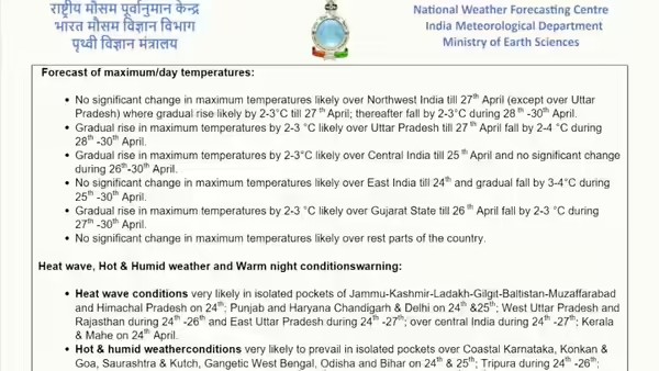
❖ No significant change in maximum temperatures likely over Western Himalayan Region till 27th April and thereafter gradual fall by 2-3°C during 28th April- 01st May.
❖ No significant change in maximum temperatures likely over plains of Northwest India till 27th April and thereafter gradual fall by 2-4°C during 28th April- 01st May.
❖ No significant change in maximum temperatures likely over East India till 26th and gradual fall by 3-4°C during 27thApril -01st May.
❖ Gradual fall in maximum temperatures by 3-6 °C likely over Northeast till 27th and thereafter no significant change during 28th April -01st May.
❖ No significant change in maximum temperatures likely over Maharashtra till 25th and thereafter gradual fall by 2-4°C during 26th April-01st May.
❖ Gradual rise in maximum temperatures by 2-3 °C likely over Gujarat State till 26th April fall by 2-4 °C during 27th -April-01st May.
❖ No significant change in maximum temperatures likely over rest parts of the country. Heat wave, Hot & Humid weather and Warm night conditions warning:
❖ Heat wave conditions very likely in isolated pockets of Jammu-Kashmir-Ladakh-Gilgit-Baltistan-Muzaffarabad,Himachal Pradesh, Uttar Pradesh, Punjab Haryana Chandigarh & Delhi and central India during 25th -27th; Rajasthan on 25th & 26th; Bihar on 25th April.
❖ Hot & humid weather conditions very likely to prevail in isolated pockets over Gangetic West Bengal on 25th; Odisha during 25th -27th; Tripura, Konkan & Goa, Gujarat State, Coastal Karnataka, Kerala & Mahe on 25th & 26th; Tamil Nadu, Puducherry & Karaikal during 25th -29th April.
❖ Warm night conditions very likely to prevail in isolated pockets over Punjab, Uttar Pradesh on 25th & 26th;Haryana, Chandigarh, Delhi during 25th -27th; Madhya Pradesh & Chhattisgarh on 27th & 28th April.Fishermen warning:Fishermen are advised not to venture into the following areas during 24th April to 29th April, 2026:
❖ Bay of Bengal: Along and off North Odisha and West Bengal coasts & over isolated parts of northwest Bay of Bengal on 26th, 27th & 28th April.
❖ Arabian Sea: No warning.
Significant rainfall recorded (in cm) (from 0830 hours IST of yesterday to 0830 hours IST of today):❖ Sub-Himalayan West Bengal & Sikkim: MAJHERDABRI T. G. 7
❖ Assam: Tezpur 7Gusty winds (in kmph) (from 0830 hours IST of yesterday to 0830 hours IST of today):
❖ Assam & Meghalaya: Mangaldai 70, Manas 56, Zrs_Shillongani 54, Kvk_Jorhat 46, Kvk_Darrang 44, Neriwalam 41, Biswanath_College_Of_Agriculture_Biswanath_Chariali 41, Cnb_Collage_Bokakhat 39, Kvk_Udalguri 39,
❖ Jammu-Kashmir: KUPWARA, GULMARG 39
❖ Punjab: SANGRUR 35
❖ Haryana: UCHANI (KARNAL) 33
❖ West Madhya Pradesh: Ujjain 43, Sehore 39, Indore 37, Dhar 35, Barwani 33, Vidhisha 31, Bhopal 31, Ashoknagar 31, Agar 30, Guna 30
❖ East Madhya Pradesh: Jabalpur 44, Sagar 39, Rewa 37, Satna 31
❖ Konkan & Goa: IIG_MO_alibag (Raigad) 30
❖ Uttarakhand: Pantnagar (AMFU) 30, Ranichawri 30ANNEXURE I• As the lead period increases forecast accuracy decrease. ANNEXURE II • Action may be taken based on ORANGE AND REDCOLOUR warnings.• Vulnerable regions likely urban and hilly areas action may be initiated for heavy rainfall warning.• As the lead period increases forecast accuracy decreases.Detailed district-wise Multi-Hazard weather warning for next five days available athttps://mausam.imd.gov.in/responsive/districtWiseWarningGIS.php ANNEXURE IIIWeather forecast over Delhi/NCR during 25th April to 28thApril 2026Past Weather: There has been no large change in maximum temperatures and rise in minimum temperatures by 1-2°C during past 24 hours over Delhi. The maximum temperatures were in the range of 42- 43°C and the minimum temperatures are in the range 24-27°C respectively during past 24 hours over Delhi. The minimum temperatures are appreciably above normal (3.1°C to 5.0°C) at a few places and above normal (1.6°C to 3.0°C) over remaining parts of Delhi. The maximum temperatures were appreciably above normal (3.1°C to 5.0°C) at most places over Delhi. Mainly clear sky with surface wind speeds up to 20 kmph from the west direction over Delhi during the past 24 hours. Mainly clear sky with surface wind speeds up to 16 kmph is likely to prevail from the west direction over the region in the forenoon today.Weather Forecast: 25.04.2026: Partly cloudy sky. Heat wave conditions at a few places. Possibility of thundery development with a spell of very light rain towards afternoon/evening. Sustained surface winds speed reaching 15-25 kmph gusting to 35 kmph during the day. The maximum temperatures over Delhi are likely to be in the range of 42°C to 44°C. The maximum temperatures will be appreciably above normal (3.0°C to 5.1°C) at most places over Delhi. The predominant surface wind is likely to be from the northwest direction with wind speed reaching upto 20 kmph during the afternoon hours. The surface wind speed will gradually decrease becoming less than15 kmph from the northwest direction during evening and night.26.04.2026: Partly cloudy sky. Heat wave conditions at isolated places. Sustained surface winds speed reaching 20- 30 kmph gusting to 40 kmph during the day. The maximum and minimum temperatures over Delhi are likely to be in the range of 41°C to 43°C and 25°C to 27°C respectively. The minimum temperature will be above normal (1.6°C to 3.0°C) at many places with appreciably above normal (3.0°C to 5.1°C) at isolated places, and maximum temperatures will be appreciably above normal (3.1°C to 5.0°C) at most places over Delhi. The predominant surface wind is likely to be from the northwest direction with surface wind speed reaching upto 15 kmph during the morning hours. The surface wind speed will be reaching upto 25 kmph from the northwest direction during the afternoon. The surface wind speed will decrease reaching upto 15 kmph from the northwest direction during evening and night.27.04.2026: Partly cloudy sky. Possibility of thundery development with a spell of very light rain towards afternoon/evening. Sustained surface winds speed 30-40 kmph gusting to 50 kmph during the day. The maximum and minimum temperatures over Delhi are likely to be in the range of 41°C to 43°C and 25°C to 27°C, respectively. The minimum temperature will be above normal (1.6°C to 3.0°C) at many places with appreciably above normal (3.0°C to 5.1°C) at isolated places, and maximum temperatures will be appreciably above normal (3.0°C to 5.1°C) at most places over Delhi. The predominant surface wind is likely to be from northwest direction with surface wind speed reaching upto 15 kmph during the morning hours. The surface wind speed will increase becoming more than 25 kmph from west direction during the afternoon. The surface wind speed will decrease becoming less than 15 kmph from the west direction during evening and night. 28.04.2026: Partly cloudy sky becoming generally cloudy sky. A spell of very light rain/ drizzle accompanied with thunderstorm/lightning/strong winds speed reaching 30- 40 gusting to 50 kmph during the day. The maximum and minimum temperatures over Delhi are likely to be in the range of 40°C to 42°C and 26°C to 28°C, respectively. The minimum temperature will be above normal (1.6°C to 3.0°C) at many places, and the maximum temperature wiil be above normal (1.6°C to 3.0°C) at many places with appreciably above normal (3.1°C to 5.0°C) at isolated places over Delhi. The predominant surface wind is likely to be from the southwest direction with wind reaching upto 10 kmph during the morning hours. The surface wind speed will be increase becoming upto 15 kmph from southeast direction during the afternoon. The surface wind speed will decrease reaching upto 12 kmph from the northeast direction during evening and night.Impact expected and action suggested due to heat wave conditions: • Warning: Heat wave conditions are expected; however, temperatures are likely to remain above normal. There may be moderate health risks, particularly for vulnerable groups such as infants, the elderly, and individuals with chronic illnesses.• Advisory: Avoid prolonged exposure to heat. Wear lightweight, light-colored, and loose cotton clothing. Cover your head using a cloth, hat, or umbrella when outdoors.Impact expected and action suggested due to isolated thunderstorm with lightning/squally winds & Hailstorm over
❖ Thundersquall (wind speed reaching 50-60 kmph gusting to 70 kmph) likely over Assam & Meghalayaon 25th & 26th; over Sub-Himalayan West Bengal & Sikkim on 25th; Gangetic West Bengal and Jharkhandduring 26th; Bihar on 26th &27th; Jharkhand during 26th -28th April.
❖ Isolated Hailstorm activity likely over Jharkhand on 26th & 27th; over North Interior Karnataka during 25th-27th April.Impact expected:
➢ Breaking of tree branches, uprooting of large avenue trees. Large dead limbs blown from trees. Damage to Standing crops.
➢ Minor to Major damage to banana and papaya trees.
➢ Minor to major damage to power and communication lines due to breaking of branches.
➢ Strong wind/hail may damage plantation, horticulture and standing crops.
➢ Hail may injure people and cattle at open places.
➢ Partial damage to vulnerable structures due to strong winds.
➢ Minor damage to kutcha houses/walls and huts.
➢ Loose objects may fly.Action suggested:
➢ People are advised to keep a watch on the weather for worsening conditions and be ready to move to safer places accordingly.
➢ Stay indoors, close windows & doors and avoid travel if possible.
➢ Take safe shelters; do not take shelter under trees.
➢ Do not lie on concrete floors and do not lean against concrete walls.
➢ Unplug electrical/ electronic appliances.
➢ Immediately get out of water bodies.
➢ Keep away from all the objects that conduct electricity.Impact Expected & Action Suggested due to heavy/very heavy rainfall over
❖ Isolated heavy rainfall likely over Arunachal Pradesh on 25th; 26th & 29th; Assam & Meghalaya on 25th & 26th; Nagaland, Manipur, Mizoram & Tripura during 27th -30th; over Sub-Himalayan West Bengal & Sikkim during 25th April- 01st May with isolated very heavy rainfall likely over Arunachal Pradesh during 27th, 28th30th April & 01st May and Assam & Meghalaya during 27th April-01st May.Impact Expected
➢ Localized Flooding of roads, water logging in low lying areas and closure of underpasses mainly in urban areas.
➢ Occasional reduction in visibility due to heavy rainfall.
➢ Disruption of traffic in major cities due to water logging in roads leading to increased travel time.
➢ Minor damage to kutcha roads.
➢ Possibilities of damage to vulnerable structure.
➢ Localized Landslides/Mudslides/landslips/mudslips/landsinks/mudsinks.
➢ Damage to horticulture and standing crops in some areas due to inundation.
➢ It may lead to riverine flooding in some river catchments (for riverine flooding please visit Web page of CWC) Action Suggested
➢ Check for traffic congestion on your route before leaving for your destination.
➢ Follow any traffic advisories that are issued in this regard.
➢ Avoid going to areas that face the water logging problems often.
➢ Avoid staying in vulnerable structure.Impact expected and action suggested due to Heat wave conditions very likely in isolated pockets of Jammu-Kashmir-Ladakh-Gilgit-Baltistan-Muzaffarabad, Himachal Pradesh, Uttar Pradesh, Punjab Haryana Chandigarh & Delhi and central India during 25th -27th; Rajasthan on 25th & 26th; Bihar on 25th April.Alert Areas
➢ High temperature & increased likelihood of heat illness symptoms in people who are either exposed to sun for a prolonged period or doing heavy work.
➢ High health concern for vulnerable people e.g. infants, elderly, people with chronic diseases.
➢ Avoid heat exposure– keep cool. Avoid dehydration.
➢ Drink sufficient water- even if not thirsty.
➢ Use ORS, homemade drinks like lassi, torani (rice water), lemon water, buttermilk, etc. to keep yourself hydrated. Agromet advisories for likely impact of Hailstorms
➢ In Sub-Himalayan West Bengal, Jharkhand and Interior Karnataka, use hail nets or hail caps in fruit orchards and vegetable plants to protect them from mechanical damage.
➢ Ensure effective field drainage to prevent waterlogging. Undertake picking of matured fruits at the earliest. Keep the harvested produce in safe places. Agromet advisories for likely impact of Heavy Rainfall
➢ In Arunachal Pradesh, shift the harvested cabbage, pea, mustard, late-maturing paddy & potatoes produce to safe places. Ensure proper drainage in the fields of rice, maize, other standing crops, vegetables, and orchards.
➢ In Assam, maintain proper drainage to avoid water stagnation in the crop fields. Prioritise immediate harvesting of the mature crops and move the produce to a dry, covered warehouse. Use plastic sheets or temporary nets to cover sensitive nursery beds.
➢ Meghalaya- Postpone sowing of carrot, okra, French bean. Provide proper drainage in maize, ginger and tomato. Provide staking/bamboo support to prevent lodging.
➢ In Sub-Himalayan West Bengal and Sikkim, ensure proper field drainage to prevent waterlogging, particularly in ginger, tomato, and Dalle Khorsani fields. Protect the nurseries of cucurbits and Dalle Khorsani by covering them with polyethylene sheets or agro-net to safeguard young seedlings. Additionally, apply locally available mulching materials in ginger fields to minimize the direct impact of rainfall. Agromet advisories for likely impact of High temperatures/ Heat Waves
➢ Maharashtra – In Konkan, irrigate green gram, vegetables, and newly planted areca nut and coconut. In Vidarbha, apply need-based light and frequent irrigation to summer green gram, groundnut, onion, sunflower, sesame, fodder crops, orchards, and vegetables during cooler hours. Use straw mulch in vegetable and orchard crops to reduce evaporation, and install shade nets for newly planted crops.
➢ Gujarat – Apply light and frequent irrigation to standing crops like cluster bean, cucumber, ridge gourd, bottle gourd, sponge gourd, and bitter gourd during morning or evening hours. Irrigate groundnut at the flowering and pegging stages.
➢ Odisha – Provide light irrigation to paddy, summer maize, green gram, black gram, groundnut, and vegetable fields. Ensure adequate soil moisture is maintained in mango and cashew crops.
➢ Madhya Pradesh – Apply light irrigation to maize, moong, urd, groundnut, and vegetable crops as required.
➢ Chhattisgarh – Apply light irrigation after weeding and hoeing in rabi maize, banana, and papaya plantations. Complete harvesting of wheat and chickpea, and ensure safe storage.
➢ Bihar – Apply light and frequent irrigation to the standing crops. Carry out mulching with crop residue, straw or polythene to minimize the loss of soil moisture. Use temporary shade nets to protect the fruit plants from high temperatures.
➢ Coastal Andhra Pradesh – Provide light irrigation to maintain adequate moisture in standing crops such as paddy, rabi maize, sorghum, chickpea, groundnut, sesame, sugarcane, vegetables, and fruit orchards.
➢ Himachal Pradesh: Apply need-based irrigation in wheat, mustard, horticulture and vegetable crops like tomato, capsicum, cabbage & cauliflower, French beans, cucumber, bitter gourd, bottle gourd etc. ➢ Uttarakhand: Provide irrigation to sunflower, fodder maize, tomato, brinjal, etc.
➢ Punjab and Haryana – Provide light irrigation to maintain adequate moisture in standing crops such as summer moong, cotton, vegetables, mango, guava & loquat.
➢ Uttar Pradesh – Provide light irrigation to maintain adequate moisture in standing crops such as hybrid maize, Zaid black gram, green gram, vegetables, and sugarcane.
➢ Rajasthan – Provide light irrigation to maintain adequate moisture in standing crops such as Zaid moong, American cotton & Desi cotton, okra, watermelon, muskmelon, tinda, cucumber & long melon.
➢ Tamil Nadu – Provide irrigation and mulching to reduce the evapotranspiration in sugarcane, cotton, banana and chilli.
➢ Kerala – Apply irrigation to banana plants and coconut palms. Ensure that there is enough moisture in the soil.
➢ Gangetic West Bengal – apply light irrigation to summer crops and vegetables to maintain soil moisture.
➢ Apply mulching to conserve soil moisture in the standing crops. Agromet advisories for likely impact of Thunderstorm / Gusty Winds
➢ Shift the harvested produce in safer places or cover the produce with tarpaulin sheets in the fields. Tie the harvested crops securely and cover them to minimize the risk of displacement from strong surface winds.
➢ Provide mechanical support to horticultural crops and staking or support to vegetables and young fruit plants / fruit-bearing plants to avoid lodging due to strong winds.Livestock / Poultry / Fisheries Keep the animals inside the shed during heavy rainfall and provide them balanced feed.
➢ Store feed and fodder in a safe place to prevent spoilage.➢ Construct an outlet with proper netting around the ponds to drain excess water, thereby preventing fish from escaping in the event of overflow.
➢ In regions with high temperatures and heat waves, provide clean, hygienic, and ample drinking water for animals, and cover the roofs of poultry sheds with grass to reduce the adverse effects. Legends & abbreviations:
❖ Heavy Rain:64.5115.5mm; Very Heavy Rain:115.6204.4mm; Extremely Heavy Rain: >204.4mm.
❖ Obsy: Observatory; Automatic Weather Station; ARG: Automatic Rain Gauge; dist: District: NH: National Highway; KVK: Krishi Vigyan Kendra; DVC: Damodar Valley Corporation; PTO: Part Time Office, Aero:Aerodrome, IAF: Indian Air Force.
❖ Region wise classification of meteorological Sub-Divisions:• Northwest India: Western Himalayan Region (Jammu-Kashmir-Ladakh-Gilgit-Baltistan-Muzaffarabad, Himachal Pradesh and Uttarakhand); Punjab, Haryana Chandigarh & Delhi; West Uttar Pradesh, East Uttar Pradesh, West Rajasthan and East Rajasthan. • Central India: West Madhya Pradesh, East Madhya Pradesh, Vidarbha and Chhattisgarh.• East India: Bihar, Jharkhand, Sub-Himalayan West Bengal & Sikkim; Gangetic West Bengal, Odisha and Andaman & Nicobar Islands.• Northeast India: Arunachal Pradesh, Assam & Meghalaya and Nagaland, Manipur, Mizoram & Tripura.• West India: Gujarat Region, Saurashtra & Kutch, Coastal Maharashtra (Konkan) & Goa, Madhya Maharashtra and Marathawada. • South India: Coastal Andhra Pradesh & Yanam, Telangana, Rayalaseema, Coastal Karnataka, North Interior Karnataka, South Interior Karnataka, Kerala & Mahe, Tamil Nadu, Puducherry & Karaikal and Lakshadweep.
Regional Precipitation:
- Hilly Regions: Jammu and Kashmir, Ladakh, Himachal Pradesh, and Uttarakhand will likely witness scattered to widespread rain, thunderstorms, and even snowfall in higher reaches.Plains: Dust storms and thundershowers are forecast for Delhi-NCR, Rajasthan, Punjab, and Haryana.Central & East India: Similar relief is expected in parts of Madhya Pradesh (April 27-29) and East India (April 27-May 1), with gradual temperature falls of 3-4°C.
IMD warns of heatwave, storms and heavy rain across these Indian states; travellers advised to plan carefully this week heading into a dramatic week of contrasting weather, with the India Meteorological Department (IMD) forecasting heatwave conditions across several northern and central regions even as thunderstorms, hailstorms and heavy rain are expected in the hills, the Northeast and parts of eastern India.

For domestic travellers, late April often marks the start of family vacations, hill station getaways and long road trips. But with temperatures soaring in the plains and rain-related disruptions possible in scenic mountain and Northeast destination this is a week when weather awareness could become just as important as hotel bookings and transport tickets.
At the same time, cooler temperatures and fresh post-rain landmark may appeal to travellers seeking relief from the plains. Those willing to plan flexibly could still enjoy the hills, especially if they keep an eye on district-level weather updates. The Northeast is likely to witness the most intense weather activity over the next several days. IMD has forecast widespread rainfall across Arunachal Pradesh, Assam, Meghalaya, Nagaland, Manipur, Mizoram and Tripura, with isolated heavy to very heavy rainfall between April 27 and April 30.
Risks and Disruptions
Twin western disturbances set to rattle India
The India Meteorological Department has issued alerts for two successive western disturbances that will bring rain, thunderstorms, snowfall, and gusty winds across large parts of India from March 26 to month-end. The rare back-to-back systems are expected to affect the hills, plains, and eastern states, impacting travel, agriculture, and daily life. Experts link this unusual March volatility to shifting weather patterns and advise preparedness for potential disruptions.
Twin disturbances to dominate late March weather
The IMD forecasts two active western disturbances—March 26 and March 28—that will drive widespread rain, thunderstorms, and snowfall across Jammu & Kashmir, Himachal Pradesh, Uttarakhand, Punjab, Haryana, Rajasthan, Delhi, and beyond. The first wave will break the dry spell in the northwest, while the second is expected to be stronger, with thundersqualls reaching up to 70 km/h on March 29–30. Eastern and northeastern states, including Assam, Meghalaya, and West Bengal, are also under heavy rain alerts during this period.
Immediate and short-term impacts on daily life
Delhi-NCR may see light rain, drizzle, and gusty winds up to 40 km/h on March 26, with temperatures swinging by several degrees. Hill states face rain in lower areas and snow in higher reaches, affecting travel. Central India could see hail and thunderstorms, while eastern and southern states brace for lightning and gusty winds, prompting safety advisories for residents and travellers.
Threat to agriculture and economic ripple effects
The timing of these disturbances coincides with the Rabi harvest, leaving crops like wheat, mustard, and gram vulnerable to lodging, rot, and fungal damage from rain, hail, and winds. UP has already reported crop losses across 25 districts, and experts warn of potential price hikes in staples and vegetables if damage spreads. Farmers are advised to cover harvested stacks and expedite harvesting where possible to minimise losses.
Why this March weather is unusual
Meteorologists attribute the volatility to a series of western disturbances, including one with a rare straight-line trough formation stretching 1,000 km from Afghanistan into India. Unlike the typical curved cyclonic path, this linear low-pressure zone is peaking during the onset of summer, not winter, and is part of a trend towards erratic pre-monsoon weather. Experts note that multiple rain spells in March are atypical, with systems arriving at lower altitudes and interacting with local heating to amplify instability.
Localised Damage: Strong gusty winds and dust storms can reduce visibility, cause traffic delays, and damage fragile buildings or standing crops.
Travel Alerts: Mountain roads in Himachal Pradesh and Uttarakhand may become slippery due to rain and fog, potentially disrupting travel to summer destinations like Shimla and Manali.