Subject: (i) Due to an active western disturbance, intense rainfall spell with hailstorm activity likely to continue over northwest India and Madhya Pradesh on today, the 08th April.
(ii) Light to moderate rainfall with hailstorm, thunderstorm & lightning activity likely to continue over east India on 08th April.
(iii) Day temperatures are likely to remain below normal to near normal over most part of northwest, central & east India during next 3-4 days and gradual become above normal thereafter.
Realised weather during past 24 hours ending at 0830 hours IST of today, the 08th April, 2026:
❖ Very Heavy rainfall (12-20 cm) has been recorded at isolated places over Odisha
❖ Heavy rainfall (7-11 cm) has been recorded at isolated places over Himachal Pradesh, Assam, Sub-Himalayan West Bengal, Coastal Andhra Pradesh and Jammu & Kashmir.
❖ Hailstorm activity reported at isolated places over Uttarakhand, Assam, West Bengal & Sikkim, Jharkhand, Odisha, Punjab, West Uttar Pradesh and West Madhya Pradesh.
❖ Thunderstorm accompanied with Squally/Gusty winds with speed 30-80 kmph prevailed at isolated places over Uttarakhand, Himachal Pradesh, Punjab, Haryana, West Rajasthan, Konkan & Goa, Madhya Maharashtra, Marathawada, Gujarat Region, Saurashtra & Kutch, West Madhya Pradesh, East Madhya Pradesh, Arunachal Pradesh, Assam & Meghalaya, Nagaland, Manipur, Mizoram & Tripura, Gangetic West Bengal, Sub Himalayan West Bengal & Sikkim, Odisha, Jharkhand, Jammu Kashmir Ladakh Gilgit Baltistan Muzaffarabad, West Uttar Pradesh, East Uttar Pradesh.
Temperature Conditions during past 24 hours till 0830 hours IST of today:
❖ Maximum/day temperatures were in the range (34°C- 40°C): Over the most part of the country except Western Himalayan region & adjoining plains of Northwest India and Northeast India. The highest maximum temperature of 42.2°C was reported at Vellore (Tamil Nadu).
❖ Maximum Temperatures/day temperatures were appreciably above normal (3.1°C to 5.0°C) at isolated places over Coastal Andhra Pradesh & Yanam and Tamil Nadu, Puducherry & Karaikal. above normal (1.6°C to 3.0°C) at few places over Sub Himalayan West Bengal & Sikkim and Lakshadweep; at isolated places over Assam & Meghalaya, Odisha, Bihar, Telangana, Rayalaseema, South Interior Karnataka and Kerala & Mahe. near normal(-1.5°C to 1.5°C) at many places over Konkan & Goa and Coastal Karnataka; at most places over Andaman & Nicobar Islands; at few places over Nagaland, Manipur, Mizoram & Tripura, East Uttar Pradesh, Jammu Kashmir Ladakh-Gilgit-Baltistan-Muzaffarabad, East Madhya Pradesh, Madhya Maharashtra, Chhattisgarh and North Interior Karnataka; at isolated places over Gangetic West Bengal, West Uttar Pradesh, Himachal Pradesh, East Rajasthan, Saurashtra & Kutch, Marathwada and Vidarbha.
❖ Minimum/night temperatures were in the range of 12–18°C over Jammu-Kashmir-Ladakh-Gilgit-Baltistan-Muzaffarabad, Himachal Pradesh, Uttarakhand, Punjab, Haryana Chandigarh & Delhi, Uttar Pradesh, Rajasthan, Madhya Pradesh, Sub-Himalayan West Bengal, Assam, Mizoram. They were in the range of 18–25°C over remaining parts of the plains of the country. Today, the lowest minimum temperature of 12.2 °C is observed at Bathinda (Punjab) over the plains of India.
❖ Minimum/night Temperature were above normal (1.6℃ to 3.0℃) over Jammu-Kashmir-Ladakh-Gilgit-Baltistan-Muzaffarabad, Gujarat State, Coastal Andhra Pradesh & Yanam, Tamil Nadu, Puducherry & Karaikal, Rayalaseema, Madhya Maharashtra and West Madhya Pradesh; appreciably below normal (-5.0°C to -3.1°C) over Delhi, Rajasthan, Gangetic West Bengal, Odisha, Vidarbha, Telangana; below normal (-3.0℃ to -1.6℃) over Punjab, Haryana, Uttar Pradesh, East Madhya Pradesh, Sub-Himalayan West Bengal & Sikkim, Assam & Meghalaya, Tripura and near normal Weather Systems, Forecast and Warnings (refer to ANNEXURE I & II):
❖ The Western Disturbance as a cyclonic circulation over north Pakistan adjoining Jammu & Kashmir in lower & upper tropospheric level.
❖ An upper air cyclonic circulation lies over northwest Uttar Pradesh & neighbourhood in lower tropospheric levels.
❖ An East-west trough from northwest Uttar Pradesh to Manipur in lower tropospheric level.
❖ An upper air cyclonic circulation lies over Chhattisgarh & neighbourhood lower tropospheric level.
❖ An upper air cyclonic circulation lies over southwest Rajasthan & adjoining south Pakistan in lower tropospheric level.
❖ A fresh Western Disturbance is likely to affect Western Himalayan Region from 11th April, 2026.
Under the influence of above systems, the following weather is likely:
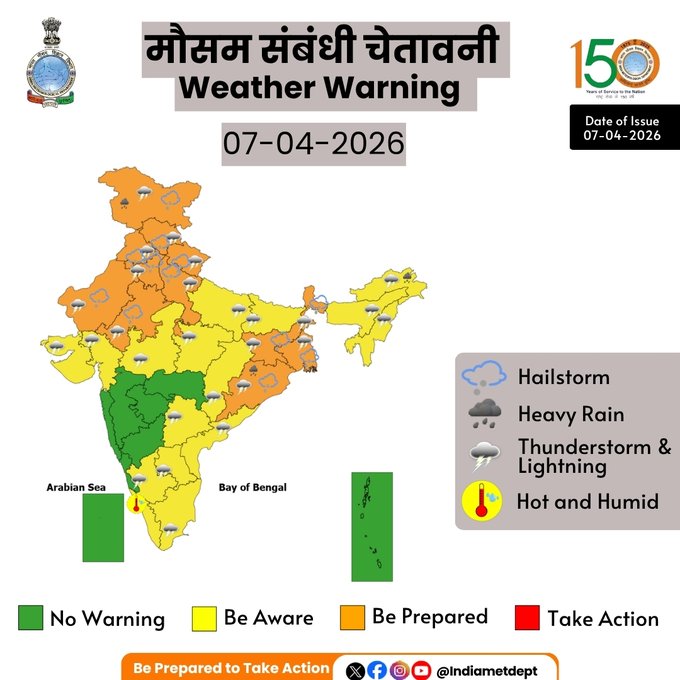
Northwest India:
❖ Widespread light to moderate rainfall/snowfall with isolated thunderstorm, lightning & gusty winds (speed reaching 40-50 kmph gusting to 60 Kmph) likely over Jammu-Kashmir, Himachal Pradesh & Uttarakhand on 8th April; Isolated to Scattered light to moderate rainfall/snowfall with isolated thunderstorm, lightning & gusty winds (speed reaching 30- 40 kmph gusting to 50 Kmph) likely over Jammu-Kashmir during 09th- 11th April, Himachal Pradesh & Uttarakhand on 09th April; Isolated to scattered light to moderate rainfall with isolated thunderstorm, lightning & gusty winds (speed reaching 40-50 kmph gusting to 60 Kmph) likely over Punjab, Haryana, Chandigarh, Delhi, Uttar Pradesh & East Rajasthan on 08thApril.
❖ Isolated hailstorm activity also likely over Jammu-Kashmir, Himachal Pradesh, Uttarakhand, Punjab, Haryana Chandigarh & Delhi and Uttar Pradesh on 8th April.
❖ Isolated heavy rainfall likely over Uttarakhand on 8th April.
Northeast India:
❖ Fairly widespread to widespread light to moderate rainfall with thunderstorm, lightning gusty winds (speed reaching 30-50 kmph) likely over Northeast India during next 5 days.
❖ Isolated heavy rainfall likely over Arunachal Pradesh on 09th& 12th; Assam & Meghalaya 9th & 10th and Tripura on 8th & 9th April.
❖ Isolated hailstorm activity also likely over Meghalaya on 8th & 9th April.
East India:
❖ Isolated to Scattered light to moderate rainfall with thunderstorm, lightning & gusty winds (speed reaching 30-50 kmph gusting to 60 kmph) likely over Sub-Himalayan West Bengal & Sikkim during 9th -12th; Gangetic West Bengal, Bihar and Jharkhand on 9th; Odisha on 9th & 10th April.
❖ Thundersquall (wind speed reaching 60-70 kmph gusting to 80 kmph) likely over Gangetic West Bengal on 08th April.
❖ Thundersquall (wind speed reaching 50-60 kmph gusting to 70 kmph) likely over Bihar, Sub-Himalayan West
Bengal & Sikkim, Jharkhand and Odisha on 08th April.
❖ Isolated Hailstorm activity likely over West Bengal, Sikkim, Bihar, Jharkhand, Odisha on 8th April.
❖ Isolated heavy rainfall likely over West Bengal & Sikkim and Odisha on 8th April.
Central India:
❖ Isolated to scattered light to moderate rainfall with thunderstorm, lightning & gusty winds (speed reaching 40-50 kmph) likely over Madhya Pradesh on 8th; Chhattisgarh during 8th – 9thApril.
❖ Isolated Hailstorm activity likely over Madhya Pradesh & Chhattisgarh on 8th April.
South Peninsular India:
❖ Isolated light to moderate rainfall with thunderstorm, lightning & gusty winds (speed reaching 40-50 kmph) likely over Coastal Andhra Pradesh & Yanam, Rayalaseema on 8th with lightning over Tamil Nadu and Telangana on 8th April.
Forecast of maximum/day temperatures:
❖ No significant change in maximum temperatures likely over Western Himalayan Region during next 24 hours, thereafter Gradual rise in maximum temperatures by 6-8 °C likely over region during 09th -14th April.
❖ No significant change in maximum temperatures likely over plains Northwest India during next 24 hours except Uttar Pradesh where it will fall by 2-4 °C, thereafter gradual increase likely by 8-10 °C over the region during 09th -14th April.
❖ No significant change in maximum temperatures likely over Central India during next 24 hours and gradual rise by 3-5°C likely during 09th -14th April.
❖ No significant change in maximum temperatures likely over East India till 09th; thereafter gradual rise by 4-6°C likely during 10th –14th April.
❖ No significant change in maximum temperatures likely over Gujarat State during next 24 hours and gradual rise by 2-4°C during 09th -14th April.
❖ Gradual rise in maximum temperatures likely over Maharashtra by 2-3°C till 11th and no significant change during 12th -14th April.
❖ No significant change in maximum temperatures likely over rest parts of the country.
❖ Overall, Day temperatures are likely to remain below normal to near normal over most part of northwest, central & east India during next 3-4 days and gradually become above normal thereafter.
Hot & Humid weather Warnings:
❖ Hot & humid conditions very likely to prevail in isolated pockets over Tamil Nadu, Puducherry & Karaikal and Kerala & Mahe on 8th & 9th; Konkan & Goa on 10th & 11th and coastal areas of Gujarat state during 11th -14th; Odisha during 12th – 14th; Coastal Karnataka during 9th -11th April
Fishermen Warning:
Fishermen are advised not to venture into the following areas during 08th April to 13th April, 2026:
Bay of Bengal: Along and off Gangetic west Bengal adjoining north Odisha coasts during on 08th April.
Arabian Sea: Over Gulf of Khambhat on 08th April.
Weather conditions and forecast over Delhi/NCR during 08th-11th April, 2026 (ANNEXURE III)
For more details, kindly refer National Weather Bulletin:
https://mausam.imd.gov.in/responsive/all_india_forcast_bulletin.php
For District wise warnings refer: https://mausam.imd.gov.in/responsive/districtWiseWarningGIS.php
For Fishermen warning refer https://rsmcnewdelhi.imd.gov.in/fishermen-warning.php
Significant rainfall recorded (in cm) (from 0830 hours IST of yesterday to 0830 hours IST of today):
❖ Assam: Dhemaji 7
❖ Sub-Himalayan West Bengal & Sikkim: Sankos T.E. 8
❖ Odisha: Chilka 14
❖ Jammu-Kashmir-Ladakh-Gilgit-Baltistan-Muzaffarabad: SMVD Bhawan 8, Argrajori 5
❖ Himachal Pradesh: Renukaji (Sangrah) 7
Past Weather:
There has been fall in minimum temperatures up to 2-4°C and fall in maximum temperatures up to 4-6°C during the past 24 hours over Delhi. The maximum temperatures were in the range of 28-29°C and the minimum temperatures were in the range of 15-17°C respectively during the past 24 hours over Delhi. The minimum temperatures are appreciably below normal (-3.1°C to -5.0°C) at many places and below normal (-1.6°C to -3.0°C) at a few places over Delhi. The maximum temperatures were markedly below normal (-5.1°C or less) at most places over Delhi. Generally cloudy sky with surface wind speeds up to 20 kmph gusting to 56 kmph from southeast direction prevailed during the past 24 hours. During the past 24 hours, light to very light rain was observed at most places across Delhi. Partly cloudy sky with surface winds speed up to 10 kmph likely to be prevailed from southwest direction over the region in the forenoon today.
Weather Forecast:
08.04.2026: Generally cloudy sky. A spell of very light/light rain accompanied by thunderstorm/lightning and surface winds of 30-40 kmph gusting to 50 kmph during the evening/night. The maximum temperatures over Delhi are likely to be in the range of 27°C to 29°C. The maximum temperatures will be markedly below normal (-5.1°C and below) over Delhi. The predominant surface wind is likely to be from the southeast direction with surface wind speed reaching up to 20 kmph during the afternoon hours. The wind speed will gradually decrease becoming less than 15 kmph from the east direction during the evening and night.
09.04.2026 Mainly clear sky. The maximum and minimum temperatures over Delhi are likely to be in the range of 30°C to 32°C and 14°C to 16°C respectively. The minimum temperature will be markedly below normal (-5.1°C and below) at isolated places with appreciably below normal (-3.1°C to -5.0°C) in the remaining parts over Delhi, and the maximum temperature will be appreciably below normal (-3.1°C to -5.0°C) at most places over Delhi. The predominant surface wind is likely to be from the northeast direction with surface wind speed reaching up to 10 kmph during the morning hours. The wind speed will increase becoming up to 16 kmph from the north direction during the afternoon. The wind speed gradually increases becoming more than 20 kmph from the north direction during the evening and night.
10.04.2026: Mainly clear sky. Strong surface wind speed 20-30 kmph during the day. The maximum and minimum temperatures over Delhi are likely to be in the range of 32°C to 34°C and 16°C to 18°C respectively.
The minimum temperature will be appreciably below normal (-3.1°C to -5.0°C) at many places, and the maximum temperature will be below normal (-1.6°C to -3.0°C) over Delhi. The predominant surface wind is likely to be from the northwest direction with wind reaching up to 20 kmph during the morning hours. The wind speed will increase up to 25 kmph from the northwest direction during the afternoon. The wind speed will gradually decrease becoming less than 15 kmph from the north direction during the evening and night.
11.04.2026: Mainly clear sky. Strong surface wind speed 20-30 kmph during the day. The maximum and minimum temperatures over Delhi are likely to be in the range of 34°C to 36°C and 17°C to 19°C respectively.
The minimum temperature will be below normal (-1.6 to -3.0°C), and the maximum temperature will be near normal (-1.5 to 1.5°C) over Delhi. The predominant surface wind is likely to be from the west direction with surface wind speed reaching up to 15 kmph during the morning hours. The wind speed will increase becoming more than 25 kmph from the northwest direction in the afternoon. The wind speed will gradually decrease becoming less than 10 kmph from the north direction during the evening and night.
Impact expected and Action Suggested due to thunderstorm with lightning/gusty winds:
- Be cautious and take precautionary measures, though there is the likelihood of thunderstorms/lightning and gusty winds (speed 30 – 50 kmph) temporarily reaching 60 kmph during thunderstorms with dust rising surface winds.
- Breaking of tree branches, uprooting of large avenue trees, Large dead limbs blown from trees, Damage to standing crops, Minor to major damage to power and communication lines due to breaking of branches, Partial damage to vulnerable structures due to strong winds, Loose objects may fly. People are advised to keep a watch on the weather for worsening conditions and be ready to move to safer places accordingly, stay indoors, close windows & doors and avoid travel, if possible, take safe shelters; do not take shelter under trees, do not lie on concrete floors and do not lean against concrete walls, unplug electrical/ electronic appliances, immediately get out of water bodies, keep away from all the objects that conduct electricity. Impact expected and action suggested due to isolated thunderstorm with lightning/squally winds & Hailstorm over
❖ Isolated hailstorm activity also likely over Jammu-Kashmir, Himachal Pradesh, Uttarakhand, Punjab, Haryana Chandigarh & Delhi and Uttar Pradesh on 8th; Meghalaya on 8th & 9th; West Bengal, Sikkim, Bihar,
Jharkhand, Odisha on 8th; West Madhya Pradesh & Chhattisgarh on 8th April.
❖ Thundersquall (wind speed reaching 60-70 kmph gusting to 80 kmph) likely over Gangetic West Bengal on 08th April.
❖ Thundersquall (wind speed reaching 50-60 kmph gusting to 70 kmph) likely over Bihar, Sub-Himalayan West Bengal & Sikkim, Jharkhand and Odisha on 08th April.
Impact expected:
➢ Breaking of tree branches, uprooting of large avenue trees. Large dead limbs blown from trees.
Damage to Standing crops.
➢ Minor to Major damage to banana and papaya trees.
➢ Minor to major damage to power and communication lines due to breaking of branches.
➢ Strong wind/hail may damage plantation, horticulture and standing crops.
➢ Hail may injure people and cattle at open places.
➢ Partial damage to vulnerable structures due to strong winds.
➢ Minor damage to kutcha houses/walls and huts.
➢ Loose objects may fly.
Action suggested:
➢ People are advised to keep a watch on the weather for worsening conditions and be ready to move to safer places accordingly.
➢ Stay indoors, close windows & doors and avoid travel if possible.
➢ Take safe shelters; do not take shelter under trees.
➢ Do not lie on concrete floors and do not lean against concrete walls.
➢ Unplug electrical/ electronic appliances.
➢ Immediately get out of water bodies.
➢ Keep away from all the objects that conduct electricity.
Impact Expected & Action Suggested due to heavy rainfall over
❖ Isolated heavy rainfall likely over Arunachal Pradesh on 09th& 12th; Assam & Meghalaya 9th & 10th and Tripura
on 8th & 9th; West Bengal & Sikkim and Odisha and Uttarakhand on 8th April.
Impact Expected
➢ Localized Flooding of roads, water logging in low lying areas and closure of underpasses mainly in urban
areas.
➢ Occasional reduction in visibility due to heavy rainfall.
➢ Disruption of traffic in major cities due to water logging in roads leading to increased travel time.
➢ Minor damage to kutcha roads.
➢ Possibilities of damage to vulnerable structure.
➢ Localized Landslides/Mudslides/landslips/mudslips/landsinks/mudsinks.
➢ Damage to horticulture and standing crops in some areas due to inundation.
➢ It may lead to riverine flooding in some river catchments (for riverine flooding please visit Web page of CWC)
Action Suggested
➢ Check for traffic congestion on your route before leaving for your destination.
➢ Follow any traffic advisories that are issued in this regard.
➢ Avoid going to areas that face the water logging problems often.
➢ Avoid staying in vulnerable structure. Agromet advisories for likely impact of Hailstorms
➢ Use hail nets or hail caps in fruit orchards and vegetable plants to protect them from mechanical damage in West Bengal & Sikkim, Odisha, Jharkhand, Bihar, Jammu & Kashmir, Himachal Pradesh, Uttarakhand, Punjab, Haryana, Uttar Pradesh, West Madhya Pradesh and Chhattisgarh.
➢ Undertake harvesting of matured crops, fruits and vegetables immediately and shift them to safer places.
Agromet advisories for likely impact of Heavy Rainfall
➢ In Arunachal Pradesh, ensure proper drainage channels in the fields of rice, maize, other standing crops, vegetables and orchards. Harvest cabbage, pea, mustard, late-maturing paddy varieties & potatoes carefully and shift the harvested produce to safe places.
➢ In Assam, make necessary arrangements to remove excess rainwater from the crop fields.
➢ In Meghalaya, ensure proper drainage in summer vegetable crops. Carry out staking and propping of plantation crops and cover the young vegetable seedlings.
➢ In West Bengal, harvest matured crops and vegetables immediately and store them in a dry, safe place to prevent damage. Drain out excess rainwater from the standing crop and vegetable fields.
➢ In Odisha, keep the harvested produce of green gram, black gram, mustard, groundnut and black pepper in the safe places. Drain out excess rainwater from the standing crops, vegetables and fruit orchards.
Agromet advisories for likely impact of Thunderstorm / Gusty Winds
➢ Shift the harvested produce in safer places or cover the produce with tarpaulin sheets in the fields. Tie the harvested crops properly and cover them to minimise the risk of displacement due to strong surface winds.
➢ Provide mechanical support to horticultural crops and staking or support to vegetables and young fruit plants / fruit-bearing plants to avoid lodging due to strong winds.
Livestock / Poultry
➢ Keep the animals inside the shed during heavy rainfall / hailstorm and provide them balanced feed.
➢ Store feed and fodder in a safe place to prevent spoilage.
➢ Construct an outlet with proper netting around the ponds to drain out excess water, thereby preventing fish from escaping in case of overflow. Legends & abbreviations:
❖ Heavy Rain:64.5-115.5mm; Very Heavy Rain:115.6-204.4mm; Extremely Heavy Rain: >204.4mm.
❖ Obsy: Observatory; Automatic Weather Station; ARG: Automatic Rain Gauge; dist: District: NH: National Highway; KVK: Krishi Vigyan Kendra; DVC: Damodar Valley Corporation; PTO: Part Time Office, Aero: Aerodrome, IAF: Indian Air Force.
❖ Region wise classification of meteorological Sub-Divisions: - Northwest India: Western Himalayan Region (Jammu-Kashmir-Ladakh-Gilgit-Baltistan-Muzaffarabad,
Himachal Pradesh and Uttarakhand); Punjab, Haryana-Chandigarh-Delhi; West Uttar Pradesh, East Uttar Pradesh, West Rajasthan and East Rajasthan. - Central India: West Madhya Pradesh, East Madhya Pradesh, Vidarbha and Chhattisgarh.
- East India: Bihar, Jharkhand, Sub-Himalayan West Bengal & Sikkim; Gangetic West Bengal, Odisha and
Andaman & Nicobar Islands. - Northeast India: Arunachal Pradesh, Assam & Meghalaya and Nagaland, Manipur, Mizoram & Tripura.
- West India: Gujarat Region, Saurashtra & Kutch, Coastal Maharashtra (Konkan) & Goa, Madhya
Maharashtra and Marathawada. - South India: Coastal Andhra Pradesh & Yanam, Telangana, Rayalaseema, Coastal Karnataka, North Interior Karnataka, South Interior Karnataka, Kerala & Mahe, Tamil Nadu, Puducherry & Karaikal and Lakshadweep.
IMD Weather Update April 8: Heavy rain, storm alert for 11 states, travel warning for…; details inside IMD Weather Update April 8: Strong winds with a speed of almost 50 kilometres per hour are expected in Delhi, Punjab, Haryana, Chandigarh, Uttar Pradesh and East Rajasthan. Scroll down to read details.

IMD Weather Update April 8: The India Meteorological Department (IMD) has issued a fresh alert for Wednesday, i.e., April 8. The weather department has warned of heavy rainfall, thunderstorms, and strong winds in several states across India. It has also cautioned against lightning strikes and possible damage because of the gusty winds, as they may reach a speed of 85 kilometres per hour.
Rain and storm alert
The states like Delhi, Uttar Pradesh, Bihar, Rajasthan, Punjab, and Haryana are likely to witness rain and thunderstorms on Wednesday, i.e., April 8. Alongside this, multiple districts are likely to witness lightning and hailstorms during this time. The weather department has advised staying indoors and also avoiding unnecessary travel during such serious times.
Weather department hints at strong winds
According to the India Meteorological Department (IMD), the speed of winds during the storm may reach a magnificent range of almost 70 to 85 kilometres per hour in some regions across the country. The strong winds may further lead to falling trees, power outages, and additional damage to the weak structures. The farmers have also been warned regarding the possibility of crop damage because of heavy rainfall and hailstorms.
Weather Update April 8: North and Central India
The rain with strong gusty winds is likely to be witnessed in Delhi with a speed of almost 50 kilometres per hour. Alongside this, Uttar Pradesh and Bihar may see moderate to heavy rainfall in some of the districts. The states like Madhya Pradesh and Rajasthan are expected to witness strong winds along with thunderstorms.
Weather Update April 8: Hilly regions
The hilly Indian regions like Himachal Pradesh and Uttarakhand are most likely to receive light to moderate rainfall over the upcoming two days.
Weather Update April 8: Eastern and Northeastern regions
Jharkhand, Odisha, and West Bengal are likely to witness heavy rainfall and thunderstorms, as per the weather department. This may cause a slight decrease in temperature in these regions. Alongside this, Assam and Meghalaya are expected to experience rain and gusty winds in the next few days.
High-Alert Regions
The IMD has specifically warned of a high potential for severe weather in the following areas:
North & Central India:
National Capital Region
Region in India
The National Capital Region is a region centred on the city of Delhi, a special union territory of India that hosts the country’s capital city New Delhi. It encompasses the entirety of Delhi and a number of adjacent districts from the states of Haryana, Uttar Pradesh, and Rajasthan. Uttar Pradesh is a state in northern India. With over 241 million inhabitants, it is the most populated state not just in India but worldwide – if it were a country, it would be the sixth-largest in the world – and accounting for 17% of the population of India and around 3% of the total world population. Punjab, a state bordering Pakistan, is the heart of India’s Sikh community. The city of Amritsar, founded in the 1570s by Sikh Guru Ram Das, is the site of Harmandir Sahib, the holiest gurdwara (Sikh place of worship). Known in English as the Golden Temple, and surrounded by the Pool of Nectar, it’s a major pilgrimage site. Also in Amritsar is Durgiana Temple, a Hindu shrine famed for its engraved silver doors. Haryana is a North Indian state surrounding New Delhi on 3 sides. The Yamuna River runs along its eastern border with Uttar Pradesh. Shared with Punjab, the state capital Chandigarh is known for its modernist buildings and gridlike street plan designed by Swiss architect, Le Corbusier. The Zakir Hussain Rose Garden features 1,600 species, while its Rock Garden showcases sculptures made with recycled materials. Rajasthan is a state in northwestern India. It is the largest Indian state by area and the seventh largest by population. It covers 342,239 square kilometres or 10.4 per cent of India’s total geographical area. Weather Today (08 April, 2026): Check IMD Rain Predictions, Snow Alert, Thunderstorms & Heat Across Delhi NCR, Mumbai, Chennai, Karnataka, Rajasthan, Jammu, Ahmedabad, Punjab, Hyderabad, Uttar Pradesh Weather Today (08 April 2026): IMD predicts rain, thunderstorms, snowfall in hills and rising temperatures across Delhi-NCR, Mumbai, Chennai, Karnataka, Rajasthan, Jammu & Kashmir, Punjab, Hyderabad and Uttar Pradesh. Check full city-wise forecast and AQI updates.

India is witnessing a mix of weather conditions on April 8, 2026, with the India Meteorological Department (IMD) predicting rain, thunderstorms, gusty winds, and rising temperatures across several regions. Weather activity is being influenced by a western disturbance and moisture-laden winds, which may trigger showers in north and central India while southern and western regions continue to experience warm and humid conditions. Below is the latest city-wise forecast and weather outlook across major Indian regions.
Will it Rain or Snow in the Hills?
According to IMD, the western disturbance moving across northwest India may bring rain and snowfall to the Western Himalayan region, including Jammu and Kashmir and Himachal Pradesh. Isolated areas may also see thunderstorms and gusty winds during the day.
How Will Weather Take Turn in North Indian Cities?
Weather across northern plains such as Delhi, Punjab, Haryana and Uttar Pradesh may remain unstable due to the same system.
The IMD has warned of light to moderate rain, thunderstorms and wind speeds of 40–50 km/h in some places, which could bring temporary relief from rising temperatures.
Delhi-NCR Weather Today
Delhi-NCR is expected to witness partly cloudy skies with chances of light rain or drizzle and thunderstorms. IMD has issued a yellow alert for the region, warning of gusty winds and brief showers across areas like Noida, Gurugram and Ghaziabad.
Temperatures are likely to remain slightly below seasonal averages due to cloud cover.
Chennai Weather Today
Chennai may see isolated rain showers and thunderstorms, triggered by heat-induced convection over Tamil Nadu. These showers could provide short-term relief from the heat, with daytime temperatures hovering around 34–35°C.
Mumbai Weather Today
Mumbai is expected to experience hot and humid conditions with partly cloudy skies. Temperatures may remain in the mid-30°C range, while coastal humidity could make the weather feel warmer during the afternoon.
Hyderabad Weather Today
Hyderabad may witness partly cloudy conditions with isolated thunderstorm activity, especially during late afternoon or evening hours. Warm temperatures are expected to continue across the city.
Karnataka Weather Today
Parts of Karnataka, including Bengaluru and interior districts, may see scattered thunderstorms and light rainfall due to convective weather activity. Daytime temperatures could remain high but may dip slightly after evening showers.
Uttar Pradesh Weather Today
Cities across Uttar Pradesh could experience cloudy skies, gusty winds and scattered rain or drizzle as western disturbances influence weather patterns.
Recent showers and storms in places like Kanpur have already brought brief relief from heat and may continue in isolated pockets.
Rajasthan Weather Today
Rajasthan may experience partly cloudy conditions with occasional dust storms or thunderstorms in some districts. Temperatures are likely to stay high during the day but may dip slightly where rain occurs.
Jammu and Kashmir Weather Today
Jammu and Kashmir is likely to witness rain in plains and snowfall in higher reaches, especially in mountainous areas. The system could bring cooler conditions and possible travel disruptions in hill districts.
Ahmedabad Weather Today
Ahmedabad may remain hot and dry with sunny skies, though occasional clouds may appear later in the day. Temperatures could approach the high-30°C range.
Punjab Weather Today
Punjab may experience scattered showers, thunderstorms and gusty winds during the day as the western disturbance affects northwest India.
Full City-Wise Rain Forecast Across Major Indian Cities
- Delhi-NCR: Light rain, thunderstorms possible
- Mumbai: Hot and humid, partly cloudy
- Chennai: Isolated showers and thunderstorms
- Hyderabad: Warm with chances of evening storms
- Bengaluru/Karnataka: Scattered rain and thunder activity
- UP cities: Cloudy with light rain in some districts
- Punjab: Thunderstorms and gusty winds
- Rajasthan: Hot with isolated storms
- Jammu & Kashmir: Rain in plains, snowfall in higher areas
How Will Rising Temperatures Impact Today?
While some regions may experience rain and thunderstorms, parts of western and peninsular India may still see high daytime temperatures, especially in coastal and interior areas.
However, April is expected to witness above-normal rainfall in several parts of India, which could delay the full onset of extreme summer heat.
Delhi-NCR Weekly Weather Forecast
April 8–9: Light rain and thunderstorms likely
April 10–11: Partly cloudy with warmer temperatures
April 12 onward: Gradual rise in daytime heat expected
Delhi’s Air Quality Today – April 8, 2026
Delhi’s air quality is expected to remain in the moderate category, though rainfall and winds may temporarily improve pollution levels in the region.
Major Cities Air Quality Across India
Delhi: Moderate
Mumbai: Moderate
Chennai: Satisfactory to moderate
Bengaluru: Satisfactory
Hyderabad: Moderate
AQI Scale Guide
0–50: Good
51–100: Satisfactory
101–200: Moderate
201–300: Poor
301–400: Very Poor
401–500: Severe
FAQ’s: Weather Today Update
Q. Are there any travel or safety warnings?
Yes. IMD has advised caution during thunderstorms, lightning and strong winds, which may disrupt flights and road travel in some regions.
Q. Will temperatures rise across the country?
Temperatures may rise gradually in many cities, though rain and cloud cover could keep parts of north and central India cooler than usual.
Q. Will there be any rain today?
Yes. Rain or thunderstorms are expected in parts of north, central and southern India, including Delhi-NCR, Tamil Nadu and some areas of Karnataka.
Q. Where will it snow today?
Higher altitudes of Jammu & Kashmir and the Western Himalayas may experience snowfall due to the ongoing western disturbance.
Q. Which cities will experience heat today?
Cities such as Mumbai, Ahmedabad and parts of Rajasthan are likely to experience warmer conditions with temperatures nearing the high-30°C range.
Disclaimer: Weather forecasts are for guidance only. Conditions may change rapidly. Always check local authorities for emergencies and travel alerts.
Severe Weather Warnings
- Gusty Winds: Wind speeds are expected to reach between 70 to 85 km/h in some regions, which could lead to falling trees and power outages.
Advisory for Farmers and Travelers
The IMD has advised the following:
- Travelers: Avoid unnecessary travel during storms as lightning and strong winds may disrupt road and air travel.
- Farmers: Take precautions against potential crop damage caused by hailstorms and heavy rain; ensure proper drainage in fields.
Odisha Braces for More Rain, Thunderstorms, and Hail Till March 25

Several parts of Odisha are set to experience continuous rain accompanied by thunderstorms, lightning, gusty winds, and hailstorms over the next few days, according to the India Meteorological Department (IMD). The prevailing weather conditions are expected to continue until March 25.
The Kalbaisakhi-induced weather system has already brought heavy rainfall and storms to many regions, offering much-needed relief from the intense heatwave. IMD forecasts suggest that this wet spell will further pull down the mercury levels, with the maximum (day) temperature likely to drop by 3 to 5 degrees Celsius across several districts.
The department has urged citizens to remain cautious, especially in areas prone to hailstorms and gusty winds. Farmers have also been advised to safeguard their crops from potential damage due to the hail and strong winds. Authorities are monitoring the situation and have asked local administrations to stay alert to any adverse weather impacts.
Ahmedabad, in western India, is the largest city in the state of Gujarat. The Sabarmati River runs through its center. On the western bank is the Gandhi Ashram at Sabarmati, which displays the spiritual leader’s living quarters and artifacts. Across the river, the Calico Museum of Textiles, once a cloth merchant’s mansion, has a significant collection of antique and modern fabrics.