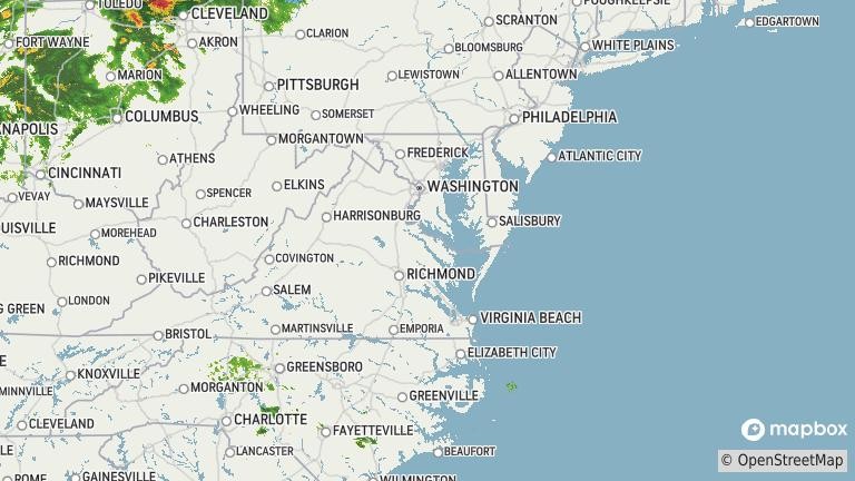
A late‑season winter storm system is expected to bring heavy snow and “hazardous” travel conditions to some parts of Colorado and New Mexico, particularly across mountainous regions, prompting multiple winter storm warnings on Thursday that are set to last until Friday, according to the National Weather Service (NWS). Separately, the NWS has issued a winter weather advisory to parts of Alaska through Thursday morning, forecasting blowing snow and reduced visibility in high‑elevation areas.
NWS forecasters warn that the combination of heavy snowfall, fluctuating snow levels and difficult road conditions is likely to disrupt travel—especially across higher elevations, including popular mountain passes and corridors—affecting commuters, commercial traffic and outdoor activities.
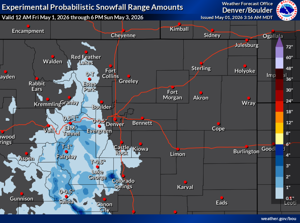
Heavy Snow Targets Colorado
In southern and central Colorado, winter storm warnings are in effect for parts of the Sangre de Cristo Mountains, Wet Mountains, Teller County, Rampart Range and Pikes Peak. These areas are forecast to receive anywhere from 8 to 16 inches of snow, with the highest amounts falling across the higher, east‑facing slopes, according to the NWS office in Pueblo. At the same time, winter weather advisories are in place for additional locations in central and north-central Colorado, spanning the Mosquito Range to Rocky Mountain National Park. These areas could see between 5 and 13 inches of snow—with more likely over higher elevations—while lower valley areas, such as the Wet Mountain Valley, may get between 3 and 7 inches.

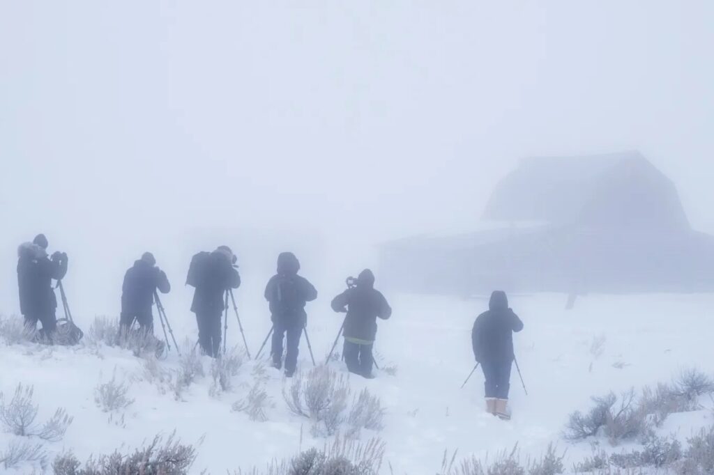
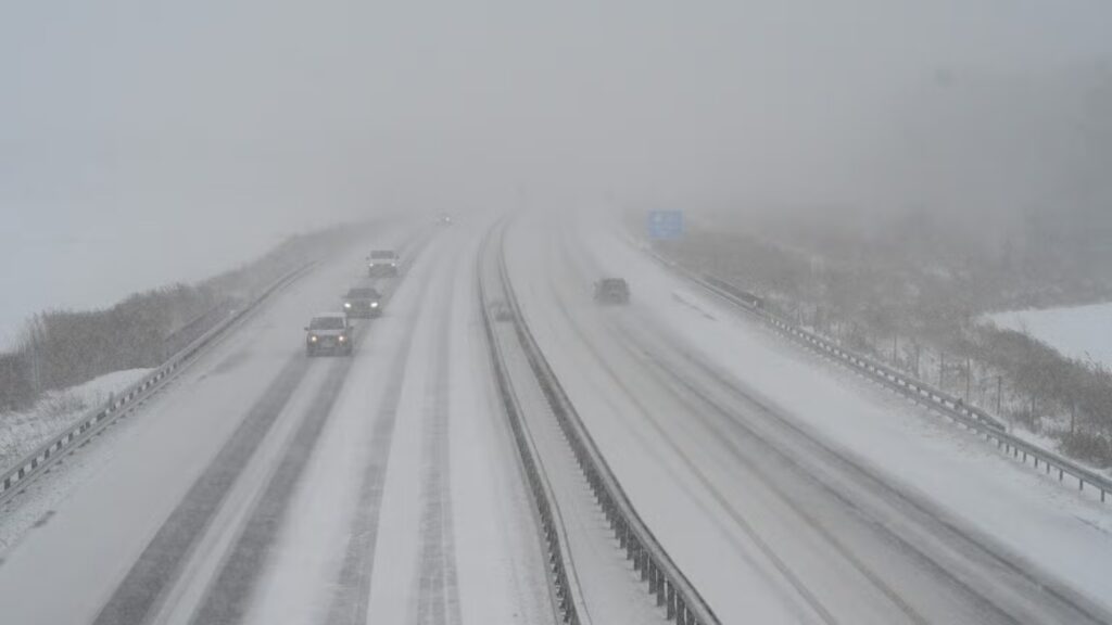
A mountain road winding through a canyon during a snowy winter whiteout in the Front Range of the Rockies in Colorado. The Rocky Mountains could see up to 13 inches of snow with the incoming snowstorm.
Snowfall is expected to begin early Thursday morning and continue through Friday, with the most hazardous travel conditions likely to be on Thursday evening into Friday morning.
An animated weather footage map from windy.com shows the anticipated snowfall amounts for the affected areas over the next three days.
The NWS cautioned that mountain passes—including La Veta Pass, Poncha Pass, Berthoud Pass and the Eisenhower Tunnel—could experience wet, slushy and snow-covered roads, making driving slow and potentially dangerous.
The heavy snow forecast is a change of pace for Colorado, which has endured an unusually dry and warm winter that left the state facing a significant snow drought, with mountain snowpack—its primary water reservoir—far below normal levels. State climatologists and federal monitoring data showed snow water equivalent hovering near record lows through late winter and early spring, the result of fewer storms and above‑average temperatures that forced much of the precipitation to fall as rain rather than snow, especially at lower elevations.
By early April, the statewide snowpack was reported at roughly one‑fifth to two‑fifths of average, and officials warned that even late‑season storms would not be enough to fully erase the deficit, raising concerns about water supplies, wildfire risk and agricultural impacts heading into summer.
The dry winter has had an economic impact as well, cutting into both operations and revenue for ski resorts during what is typically their busiest season. And although the late-season snowfall might provide a slight boost to Colorado’s snowpack, the only two ski resorts still open, which are Arapahoe Basin and Copper Mountain, will close on May 3, the Coloradoan reported.

People ride the gondola at Breckenridge Ski Resort as temperatures reach into the 50s on March 18, 2026, in Breckenridge, Colorado. Some snow is set to hit Colorado this week, but the ski resort closed on April 19. (Photo by Michael Ciaglo/Getty Images)
New Mexico Should Prepare for Heavy Snowfall
Further south, northern New Mexico faces its own winter storm warning, covering the Sangre de Cristo Mountains and Raton Pass, where snow levels are expected to reach up to 14 inches—especially in areas near 10,000 feet—from Thursday afternoon until Friday night. The snowfall is expected to affect travel across mountain highways, and tire chains are recommended. The NWS said the heaviest snow was likely to be through Thursday night into Friday morning.
Alaska Advisory Highlights ‘Blowing Snow’ Risks
Meanwhile, in northern Alaska, a winter weather advisory remains in effect for the central Brooks Range, including Atigun Pass along the Dalton Highway. Additional snow accumulations of up to 3 inches, combined with wind gusts reaching about 30 mph, could create periods of blowing snow, which might reduce visibility to less than half a mile at times.
How Heavy Snow Affects Daily Life
Heavy mountain snowfall can affect more than road travel. Wet, dense snow increases the risk of vehicle accidents, road closures, delayed emergency response times and power outages, particularly when snow accumulates rapidly.
In higher terrain, changing snow levels can also heighten avalanche danger and complicate backcountry travel.
How To Prepare Before and After the Winter Storms
The NWS is urging residents and travelers in affected areas to prepare for the possibility of heavy snowfall ahead of time, especially in mountainous regions.
Before the storm, residents should consider the following:
- Check local road conditions by either calling 511 or monitoring official Department of Transportation websites.
- Avoid nonessential travel, particularly over mountain passes.
- Stock vehicles with emergency kits, including shovels, nonperishable food, drinking water, blankets, flashlights (with spare batteries) and extra clothes.
After the storm, residents should consider the following:
- Allow extra time for crews to clear the roads.
- Watch out for black ice and compacted snow, even after the snowfall ends.
- Clear snow from walkways and roofs to reduce the risk of injury.
- Monitor updated forecasts, as additional advisories or warnings may follow.
With winter conditions lingering into late April and early May, forecasters stress that mountain weather can change rapidly, even as lower elevations experience springlike conditions.
Is More Snow Expected for Colorado, New Mexico and Alaska?
The NWS warns that while conditions will dry out briefly on Saturday, parts of Colorado could see additional rain and snow showers beginning on Sunday and continuing into next week—Heavy Snow Warning, up to 12 Inches To Hit—‘Dangerous Conditions’
URGENT - WINTER WEATHER MESSAGE
National Weather Service Denver CO
1102 PM MDT Thu Apr 30 2026

COZ033-034-037-011200-
/O.CON.KBOU.WW.Y.0016.000000T0000Z-260501T1200Z/
South and East Jackson/Larimer/North and Northeast
Grand/Northwest Boulder Counties Above 9000 Feet-South and
Southeast Grand/West Central and Southwest Boulder/Gilpin/Clear
Creek/Summit/North and West Park Counties Above 9000 Feet-Central
and Southeast Park County-
Including the cities of Williams Fork Mountains, Lake George, South
Park, Rocky Mountain National Park, Rabbit Ears Range, Winter Park,
Fairplay, Eisenhower Tunnel, East Slopes Mosquito Range, Indian
Peaks, Hartsel, Breckenridge, East Slopes Southern Gore Range, Mount
Blue Sky, Berthoud Pass, Kenosha Mountains, Laramie and Medicine Bow
Mountains, Cameron Pass, and Willow Creek Pass
1102 PM MDT Thu Apr 30 2026

...WINTER WEATHER ADVISORY REMAINS IN EFFECT UNTIL 6 AM MDT FRIDAY...

* WHAT...Snow. Additional snow accumulations between 1 and 4 inches,
  with storm totals of 4 to 10 inches. The heaviest amounts will be
  in the Front Range Mountains south of I-70 and in the Mosquito
  Range. Lighter snow totals west of the Front Range including the
  valleys of Summit County.

* WHERE...Rocky Mountain National Park and the Medicine Bow Range,
  the mountains of Summit County, the Mosquito Range, the Indian
  Peaks, and South Park.

* WHEN...Until 6 AM MDT Friday.

* IMPACTS...Travel could be hazardous due to slushy and snow covered
  roads at times.

PRECAUTIONARY/PREPAREDNESS ACTIONS...

Slow down and use caution while traveling. The latest road conditions
for Colorado can be obtained by calling 5 1 1 or by going to
www.cotrip.org.

Roads will be slick resulting in slow and hazardous travel. Allow
extra time to reach your destination.

&&

$$

For more information from the National Weather Service, visit
https://weather.gov/bou

MV
URGENT – WINTER WEATHER MESSAGE
National Weather Service Pueblo CO
753 PM MDT Thu Apr 30 2026
COZ058-063-076-011000-
/O.CON.KPUB.WW.Y.0010.000000T0000Z-260501T1800Z/
Western Mosquito Range/East Lake County Above 11000 Feet-Western
Mosquito Range/East Chaffee County Above 9000 Feet-Northwestern
Fremont County Above 8500 Feet-
Including Climax
753 PM MDT Thu Apr 30 2026
…WINTER WEATHER ADVISORY REMAINS IN EFFECT UNTIL NOON MDT FRIDAY…
* WHAT…Snow. Additional snow accumulations between 2 and 4 inches.
* WHERE…Northwestern Fremont County Above 8500 Feet, Western
Mosquito Range and East Chaffee County Above 9000 Feet, and
Western Mosquito Range and East Lake County Above 11000 Feet.
* WHEN…Until noon MDT Friday.
* IMPACTS…Travel could be difficult, especially over mountain
passes, with wet, slushy and snowpacked roads.
PRECAUTIONARY/PREPAREDNESS ACTIONS…
Slow down and use caution while traveling. The latest road
conditions for the state you are calling from can be obtained by
calling 5 1 1.
Colorado
The latest on the state of Colorado. Located in the Western United States, Colorado has a population of just under 6 million. The state’s largest city and its capital is Denver. The state is home to many national parks.
Wyoming
Wyoming is a state in the western United States. Known as the “Equality State,” the state was the first state to grant women the right to vote in 1869.
Areas Impacted by Heavy Snow
Here’s where conditions are expected to be most severe across the region.
Montana
Montana is a state located in the western region of the United States. It is known for the Rocky Mountains, Yellowstone National Park, and Glacier National Park. The capital city is Helena, and the largest city is Billings. In Colorado, parts of the south central area, including the higher elevations of the eastern Sawatch and San Juan Mountains, could see between 5 and 10 inches of snow with winds reaching 45 mph until around midnight on Sunday. The NWS has warned that visibility will be reduced due to blowing snow, which is likely to make travel “very difficult.”
In central and western parts of the state, including the Flat Tops, Battlement Mesas, and the West Elk Mountains, as much as 12 inches of snow could hit, coupled with 45 mph winds, lasting through Sunday, until around midnight. In Wyoming, south central and southeastern area, including the Sierra Madre and Snowy Ranges, are forecast to get between 6 and 12 inches of snow, especially across the higher elevations through Sunday and overnight, before petering out on Monday morning. Hikers, hunters, and snowmobilers have been warned that conditions could be “dangerous” as falling and blowing snow could reduce visibility, which could become seriously disorienting.
Drivers should prepare for “slippery” road conditions, especially along Interstates 25 and 90 north and east of Buffalo, the NWS says.
Parts of the north-central and northwest of the state are also likely to be affected by heavy snowfall from Sunday afternoon until Monday morning, as between 3 and 10 inches is expected to fall, which will make travel difficult—especially for the Powder River and Granite Passes—and potentially impact the Monday morning commute. Some counties, particularly northeast Johnson County, could also get strong winds, reaching 35 mph during this time. In Montana, areas in the north central region along the Rocky Mountain Front could get up to 6 inches of snow, especially along Marias Pass, with lesser amounts forecast for the plains and foothills, until around noon on Sunday.
Between 4 and 9 inches of snow is forecast for some south central and south central‑eastern parts of the state, particularly the Pryor Mountains and the northern Bighorn Mountains near the Wyoming border, from Sunday afternoon until around noon on Monday.
Forecast for the Week Ahead: Is More Snow Expected?
After the weekend storm, conditions are expected to ease across the region, as the NWS predicts typical conditions for the time of year. According to the seven-day outlook, there will be chances of snow showers, mainly in the afternoons and evenings. Daytime highs will generally range from the low-40s to the low-50s, with overnight lows in the mid‑20s. Winds will be gusty, especially from Sunday through to Thursday. But, despite the repeated chance of snow, little or no accumulation is expected, and the overall conditions will gradually become a bit warmer and drier by next weekend.
What the Advisory Means—and How to Stay Safe
A NWS weather advisory is issued when winter conditions are expected to cause significant inconvenience or hazardous travel, but aren’t severe enough to meet the criteria for a warning, such as a Winter Storm Warning or an Ice Storm Warning.
For winter weather, an advisory often covers freezing rain, light ice accumulation, sleet, or a few inches of snow—conditions that can still make roads slippery, reduce visibility, and disrupt daily routines. Unlike a winter weather watch, which signals a possible threat, an advisory means hazardous weather is likely and already impacting or about to impact the area. Even when conditions don’t rise to warning levels, winter weather advisories should be taken seriously, especially by drivers, older adults, and anyone who has to travel.
The NWS recommends:
- Limit travel if possible, particularly during early‑morning and evening commute hours, when untreated roads are the most dangerous.
- If driving is unavoidable, drivers should slow down and increase the distance between the car in front.
- If leaving the house, dress in warm, layered clothing.
- Check local forecasts and road conditions frequently, as advisories can be upgraded to warnings if conditions worsen.
- Prepare homes and vehicles with emergency kits, flashlights, blankets, and extra calorie-dense, non-perishable food and also drinking water in case of power outages or travel disruptions.
Officials also urge people to watch for rapidly changing conditions, because light freezing rain or sleet can quickly lead to dangerous ice accumulation, even when snowfall totals seem low. For New Mexico, the NWS isn’t forecasting any additional snow after Friday, as temperatures remain warm. Any precipitation midweek is likely to fall as rain, even in higher‑elevation areas.
Alaska, however, faces a different outlook. The NWS says the state could see multiple chances for rain and snow until at least Tuesday, particularly overnight and at higher elevations, where Heavy Snow Warning As 18 Inches To Hit This Weekend: ‘Very Hazardous’
Alaska
The latest on the state of Alaska. Located in the northwest extremity of North America, Alaska has a population of just over 700,000 people. The state’s largest city is Anchorage and the state’s capital is Juneau. Admitted to the Union on January 3, 1959, it was the 49th state. In Alaksa, forecasters caution that snow and wind gusts could lead to “very difficult” travel conditions. For the Yukon Delta coast, the agency said snow, as well as blowing snow is expected, with total snow accumulations between three and seven inches and wind gusts as high as 45 miles per hour.
As for the Kuskokwim Delta coast and Nunivak Island alert, between three and eight inches of snow is possible, according to the agency.
These warnings are in force from 10 a.m. Saturday to 10 a.m. AKDT Sunday as of reporting. “A Winter Storm Warning for snow means severe winter weather conditions will make travel very hazardous,” the alert read. Winter Storm Warning Issued in Colorado and New Mexico and Freeze Warnings in Multiple States
URGENT - WINTER WEATHER MESSAGE
National Weather Service Pueblo CO
252 AM MDT Fri May 1 2026

COZ072>075-079-080-011700-
/O.CON.KPUB.WS.W.0005.000000T0000Z-260502T0600Z/
Northern Sangre de Cristo Mountains Between 8500 And 11000 Feet-
Northern Sangre de Cristo Mountains Above 11000 Feet-Southern
Sangre de Cristo Mountains Between 7500 and 11000 Feet-Southern
Sangre de Cristo Mountains Above 11000 Feet-Wet Mountains between
6300 and 10000 Feet-Wet Mountains Above 10000 Feet-
Including Blanca Peak, Stonewall, Spanish Peaks, Rye, Poncha
Pass, Weston, La Veta Pass, and Cuchara
252 AM MDT Fri May 1 2026

...WINTER STORM WARNING REMAINS IN EFFECT UNTIL MIDNIGHT MDT
TONIGHT...

* WHAT...Snow. Additional snow accumulations between 3 and 6 inches.

* WHERE...Sangre de Cristo Mountains, and Wet Mountains.

* WHEN...Until midnight MDT tonight.

* IMPACTS...Travel could be difficult, especially over mountain
  passes, with wet, slushy and snowpacked roads.

PRECAUTIONARY/PREPAREDNESS ACTIONS...

If you must travel, keep an extra flashlight, food, and water in
your vehicle in case of an emergency. The latest road conditions for
the state you are calling from can be obtained by calling 5 1 1.

&&

$$
URGENT - WINTER WEATHER MESSAGE
National Weather Service Pueblo CO
252 AM MDT Fri May 1 2026

COZ081-082-011700-
/O.CON.KPUB.WS.W.0005.000000T0000Z-260501T1800Z/
Teller County/Rampart Range Above 7500 Feet/Pikes Peak Between
7500 And 11000 Feet-Pikes Peak Above 11000 Feet-
Including Pikes Peak and Woodland Park
252 AM MDT Fri May 1 2026

...WINTER STORM WARNING REMAINS IN EFFECT UNTIL NOON MDT TODAY...

* WHAT...Snow. Additional snow accumulations between 3 and 6 inches.

* WHERE...Teller County and the Rampart Range including Pikes Peak.

* WHEN...Until noon MDT today.

* IMPACTS...Travel could be difficult, with wet, slushy and
  snowpacked roads. Hazardous conditions could impact the Friday
  morning commute.

PRECAUTIONARY/PREPAREDNESS ACTIONS...

If you must travel, keep an extra flashlight, food, and water in
your vehicle in case of an emergency. The latest road conditions for
the state you are calling from can be obtained by calling 5 1 1.

&&

$$
URGENT - WINTER WEATHER MESSAGE
National Weather Service Albuquerque NM
131 AM MDT Fri May 1 2026

NMZ213>215-011830-
/O.CON.KABQ.WS.W.0005.000000T0000Z-260502T0600Z/
Northern Sangre de Cristo Mountains-Southern Sangre de Cristo
Mountains-East Slopes Sangre de Cristo Mountains-
131 AM MDT Fri May 1 2026

...WINTER STORM WARNING REMAINS IN EFFECT UNTIL MIDNIGHT MDT
TONIGHT...

* WHAT...Heavy snow. Additional snow accumulations of 2 to 6 inches
  above 7,500 feet with higher amounts of 6 to 12 inches above 10,000
  feet.

* WHERE...Sangre de Cristo Mountains.

* WHEN...Until midnight MDT tonight.

* IMPACTS...Travel could be very difficult. Tire traction will be
  reduced. Extend the distance between your vehicle and the vehicle
  in front of you.

PRECAUTIONARY/PREPAREDNESS ACTIONS...

If you must travel, keep an extra flashlight, food, and water in your
vehicle in case of an emergency. For the latest road conditions, dial
511 or 1.800.432.4269, or visit http://nmroads.com.

&&

$$
At the same time, frigid air behind this system is sweeping across the country, threatening crops and sensitive vegetation with sub-freezing temperatures in over a dozen states.
Southern Rockies Expecting Heavy Snow
Winter storm warnings are in effect across the Sangre de Cristo and Wet Mountains through midnight Friday.
In New Mexico, additional snow accumulations between 6 and 10 inches are forecast above 9,500 feet. The heaviest snow is expected through Friday morning, with snow levels dropping to 7,500 feet. In Colorado, additional accumulations of 3 to 6 inches are expected across the mountains and the Rampart Range, including Pikes Peak and Woodland Park. When combined with previous totals, the highest peaks face a total potential of nearly two feet of accumulation. “Travel could be very difficult. Tire traction will be reduced,” the NWS said. “If you must travel, keep an extra flashlight, food, and water in your vehicle in case of an emergency.”
Freeze Warnings Sweep Across Multiple States
The impact of this cold front extends far beyond the mountain peaks. In Utah and Idaho, temperatures are expected to drop as low as 28 degrees, threatening early-season blooms. Further east, Wisconsin and Michigan are bracing for a hard freeze, with interior areas of Michigan potentially seeing lows reach 22 degrees by Saturday morning.
The NWS warns that these frost and freeze conditions could kill crops and damage unprotected outdoor plumbing. Residents in affected regions are urged to take steps now to protect tender plants and drain in-ground sprinkler systems. At the same time, frigid air behind this system is sweeping across the country, threatening crops and sensitive vegetation with sub-freezing temperatures in over a dozen states.
Southern Rockies Expecting Heavy Snow
Winter storm warnings are in effect across the Sangre de Cristo and Wet Mountains through midnight Friday.
In New Mexico, additional snow accumulations between 6 and 10 inches are forecast above 9,500 feet. The heaviest snow is expected through Friday morning, with snow levels dropping to 7,500 feet. In Colorado, additional accumulations of 3 to 6 inches are expected across the mountains and the Rampart Range, including Pikes Peak and Woodland Park. When combined with previous totals, the highest peaks face a total potential of nearly two feet of accumulation.
“Travel could be very difficult. Tire traction will be reduced,” the NWS said. “If you must travel, keep an extra flashlight, food, and water in your vehicle in case of an emergency.” In Utah and Idaho, temperatures are expected to drop as low as 28 degrees, threatening early-season blooms. Further east, Wisconsin and Michigan are bracing for a hard freeze, with interior areas of Michigan potentially seeing lows reach 22 degrees by Saturday morning.
The NWS warns that these frost and freeze conditions could kill crops and damage unprotected outdoor plumbing. Residents in affected regions are urged to take steps now to protect tender plants and drain in-ground sprinkler systems.
Travel Impacts & Alerts
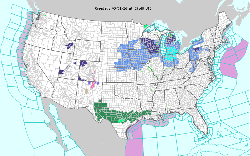
Short Range Forecast Discussion NWS Weather Prediction Center College Park MD 305 AM EDT Fri May 01 2026 Valid 12Z Fri May 01 2026 – 12Z Sun May 03 2026 …Heavy rain expected to continue in Texas and the Lower Mississippi Valley today, before migrating eastward…. …A developing coastal low will bring rain chances to the Southeast and Northeast over the weekend… …Much-below-average temperatures are forecast for much of the eastern and southern U.S. through the weekend… A stationary frontal boundary will continue to bring heavy rainfall for Texas and portions of the Lower Mississippi Valley today. A potent and slow-moving upper-level trough will continue feeding in upper-level energy to the region, and a prolonged influx of moisture will continue flowing onshore from the warmer Gulf. This will continue to support heavy showers and thunderstorms as the stationary front supports continuous rounds. The stubborn precipitation along with antecedent rainfall from previous days will result in scattered instances of flash flooding. As such, a Slight Risk of Excessive Rainfall (level 2/4) remains in the outlook today for Texas and portions of the Lower Mississippi Valley. Precipitation will finally subside in the region late on Friday evening/overnight Saturday morning, as the front begins to move into the Gulf, aided by a building surface ridge. To start the weekend, the aforementioned front will bring showers and thunderstorms to the Southeast and Florida, as a coastal low begins to materialize. The heaviest precipitation and strongest thunderstorms are expected in northern Florida, as a combination of a robust low-level jet, inflow of comparatively warm and moist air from the Gulf, and the presence of the cold front as a lifting mechanism, develops. Thunderstorms in the region will have the potential to be severe, bring a risk of damaging winds, and isolated hail. As a result, there is a Slight Risk of severe thunderstorms for Saturday, per the Storm Prediction Center�s Convective Outlook. As these frontal systems continue their way through their respective regions, significantly below-average temperatures will linger through the weekend for much of the eastern and southern regions of the U.S. Temperatures in the Southern Plains and Southern Rockies could drop around 30 degrees below the seasonal average. Texas and parts of the Lower Mississippi Valley may potentially set record-low daily maximum temperatures, with widespread temperatures in the 50s expected. Much-below-average temperatures are also expected in the Southeast, Mid-Atlantic, Northeast, and Midwest regions. Freeze warnings and Frost advisories are currently in effect for parts of the Great Lakes. Further west, above-average temperatures will spread through the Pacific Northwest, Northern and Central Great Basin, and California, before moving eastward. Temperatures in the Pacific Northwest could be especially high, with temperatures in the mid-80s and even approaching 90 expected. Winter Storm Watch: Up to 14 Inches of Snow and Hazardous Travel Expected in New Mexico The calendar is ready to turn to May, but winter is still making its presence felt in certain parts of the United States. Multiple winter storm warnings and watches have been issued for later in the week.
According to the National Weather Service (NWS), several areas of New Mexico–the Sangre de Cristo Mountains, and Johnson and Bartlett Mesas Including Raton Pass–are preparing for heavy snow and potentially dangerous travel in the coming days.
Over one foot of snow possible Snow accumulations are expected to be between 3 and 8 inches between 7500 and 9500 feet and 8 to 14 inches above 9500 feet. Travel could prove “very difficult,” with tire chains necessary when driving through mountain passes.
“Snow levels will be between 9000 to 10000 feet during the onset of precipitation on Thursday, dropping to around 7500 feet Friday morning following the passage of a cold front,” NWS Albuquerque said. “The period of heaviest snow is expected late Thursday night through Friday morning.”
More snow, freezing temps expected elsewhere Winter Storm Watch Issued as 3 Feet of Snow, Record Freezing Temperatures Approach May is nearly here, but the winter weather just won’t quit.
The National Weather Service advised “heavy” snow is coming for two states while Accuweather revealed the “record” freezing temperatures expected across the United States later this week.
Key Points
- The National Weather Service updated its forecast with three feet of snow possible in Colorado.
- Wyoming is also set to receive heavy snowfall despite two winter storms in the past week.
- The Southeast is bracing for record freezing temperatures, 30 degrees lower than normal.
May is nearly here, but the winter weather just won’t quit.

The National Weather Service advised “heavy” snow is coming for two states while Accuweather revealed the “record” freezing temperatures expected across the United States later this week.
Short Range Forecast Discussion NWS Weather Prediction Center College Park MD 305 AM EDT Fri May 01 2026 Valid 12Z Fri May 01 2026 – 12Z Sun May 03 2026 …Heavy rain expected to continue in Texas and the Lower Mississippi Valley today, before migrating eastward…. …A developing coastal low will bring rain chances to the Southeast and Northeast over the weekend… …Much-below-average temperatures are forecast for much of the eastern and southern U.S. through the weekend… A stationary frontal boundary will continue to bring heavy rainfall for Texas and portions of the Lower Mississippi Valley today. A potent and slow-moving upper-level trough will continue feeding in upper-level energy to the region, and a prolonged influx of moisture will continue flowing onshore from the warmer Gulf. This will continue to support heavy showers and thunderstorms as the stationary front supports continuous rounds. The stubborn precipitation along with antecedent rainfall from previous days will result in scattered instances of flash flooding. As such, a Slight Risk of Excessive Rainfall (level 2/4) remains in the outlook today for Texas and portions of the Lower Mississippi Valley. Precipitation will finally subside in the region late on Friday evening/overnight Saturday morning, as the front begins to move into the Gulf, aided by a building surface ridge. To start the weekend, the aforementioned front will bring showers and thunderstorms to the Southeast and Florida, as a coastal low begins to materialize. The heaviest precipitation and strongest thunderstorms are expected in northern Florida, as a combination of a robust low-level jet, inflow of comparatively warm and moist air from the Gulf, and the presence of the cold front as a lifting mechanism, develops. Thunderstorms in the region will have the potential to be severe, bring a risk of damaging winds, and isolated hail. As a result, there is a Slight Risk of severe thunderstorms for Saturday, per the Storm Prediction Center�s Convective Outlook. As these frontal systems continue their way through their respective regions, significantly below-average temperatures will linger through the weekend for much of the eastern and southern regions of the U.S. Temperatures in the Southern Plains and Southern Rockies could drop around 30 degrees below the seasonal average. Texas and parts of the Lower Mississippi Valley may potentially set record-low daily maximum temperatures, with widespread temperatures in the 50s expected. Much-below-average temperatures are also expected in the Southeast, Mid-Atlantic, Northeast, and Midwest regions. Freeze warnings and Frost advisories are currently in effect for parts of the Great Lakes. Further west, above-average temperatures will spread through the Pacific Northwest, Northern and Central Great Basin, and California, before moving eastward. Temperatures in the Pacific Northwest could be especially high, with temperatures in the mid-80s and even approaching 90 expected. “The approach of the more substantial upper-wave over the Southwest to south-central U.S. will encourage more widespread, heavier precipitation across the central Rockies/adjacent High Plains Thursday. Heavy snow is forecast for the mountains with the potential that some snow may mix in for the foothills/Palmer Divide.” Up to 3 Feet of Snow in Colorado, 10 Inches in Wyoming Rockies have dealt with significant snowfall in recent days and the latest forecast from the NWS shows that’s not ending any time soon.

Detailed Forecast
Overnight
A 40 percent chance of snow showers. Mostly cloudy, with a low around 11. South wind around 5 mph becoming calm.
Friday
Snow showers likely, mainly between 2pm and 4pm. The snow could be heavy at times. Some thunder is also possible. Mostly cloudy, with a high near 20. Light and variable wind becoming north northeast 5 to 10 mph in the morning. Chance of precipitation is 60%. New snow accumulation of 3 to 7 inches possible.
Friday Night
A 20 percent chance of snow showers before 8pm. Partly cloudy, with a low around 13. Wind chill values between zero and 10. North northeast wind 5 to 10 mph becoming west northwest after midnight.
Saturday
Sunny, with a high near 28. Wind chill values between zero and 10. West wind 5 to 10 mph becoming south in the afternoon.
Saturday Night
Mostly clear, with a low around 21. Breezy, with a south wind 15 to 20 mph becoming west after midnight. Winds could gust as high as 30 mph.
Sunday
A 20 percent chance of snow showers after noon. Some thunder is also possible. Partly sunny, with a high near 33. Breezy, with a west wind 15 to 20 mph decreasing to 10 to 15 mph in the afternoon. Winds could gust as high as 30 mph.
Sunday Night
A 20 percent chance of snow showers before midnight. Mostly cloudy, with a low around 24. Breezy, with a west wind 10 to 15 mph increasing to 15 to 20 mph after midnight. Winds could gust as high as 35 mph.
Monday
Snow showers likely after noon. Some thunder is also possible. Partly sunny, with a high near 31. Windy, with a west wind 25 to 30 mph decreasing to 15 to 20 mph in the afternoon. Winds could gust as high as 40 mph. Chance of precipitation is 70%.
Monday Night
Snow showers likely, mainly before midnight. Some thunder is also possible. Mostly cloudy, with a low around 21. West wind 10 to 15 mph. Chance of precipitation is 60%.
Tuesday
Snow showers likely, mainly after noon. Some thunder is also possible. Partly sunny, with a high near 26. West southwest wind around 15 mph. Chance of precipitation is 70%.
Tuesday Night
Snow showers likely. The snow could be heavy at times. Mostly cloudy, with a low around 19. West wind around 10 mph.
Wednesday
A chance of snow showers. Some thunder is also possible. Partly sunny, with a high near 22. West northwest wind around 15 mph.
Wednesday Night
Partly cloudy, with a low around 19. West southwest wind 10 to 15 mph.
Thursday
Sunny, with a high near 35. West wind 10 to 15 mph.
Rain Coming to Drought-Stricken Southern U.S.
A storm tracking across the Southern U.S. will bring heavy to excessive rainfall over portions of west-central Texas into tonight then from central Texas through the central Gulf Coast on Friday. The Southeast U.S. will see heavier rain Saturday. While much of this rainfall will be beneficial to the drought, excessive rainfall may bring areas of flash and urban flooding.
The purpose of these experimental probabilistic snowfall products is to provide customers and partners a range of snowfall possibilities, in complement to existing NWS deterministic snowfall graphics, to better communicate forecast uncertainties during winter weather events. For more information visit this project’s and please provide us your feedback.
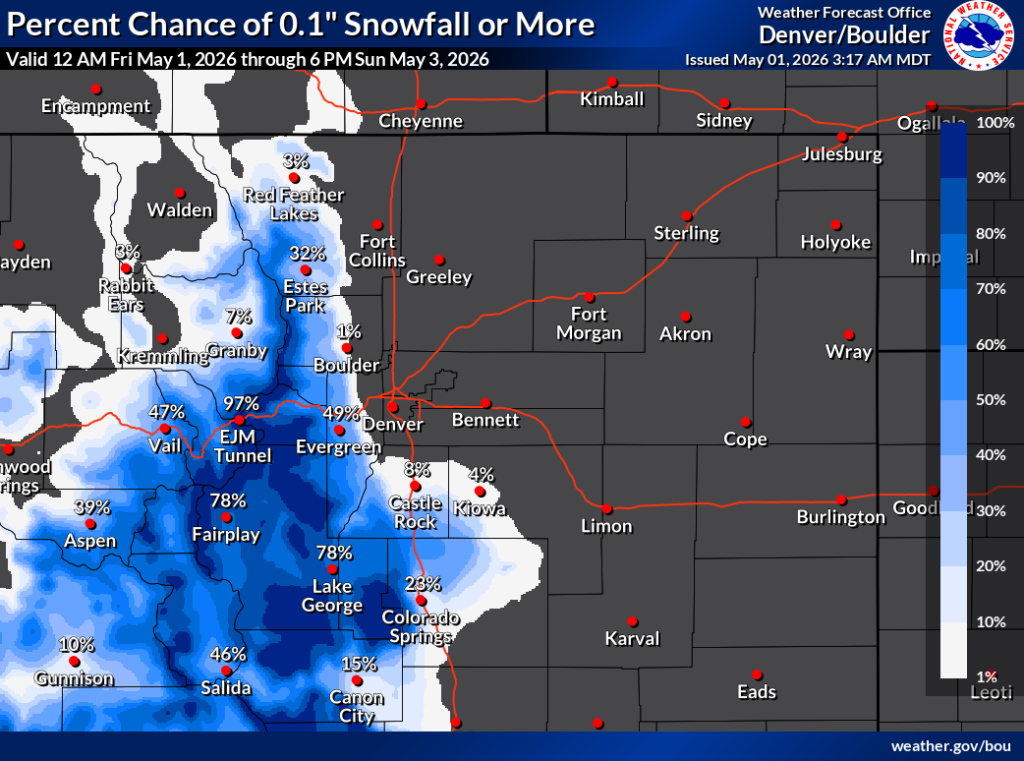
Probabilistic Snowfall Products
Probabilistic snowfall products are intended to provide a range of snowfall possibilities. These products complement the existing NWS forecast in order to better communicate forecast uncertainty and enhance Impact-based Decision Support Services (IDSS) before and during winter weather events.
Probabilistic snowfall products are currently available across the contiguous United States, including 116 of the 122 local NWS Weather Forecast Offices. These experimental forecast products help to explain the range of snowfall possibilities for upcoming winter storms (most likely snowfall, maximum and minimum snowfall), helping everyone make better decisions on what action to take.
Knowing the forecast and adequately preparing for a storm can lessen the impacts associated with hazardous winter weather. For more information on how to interpret these products, please see the fact sheet and video below.
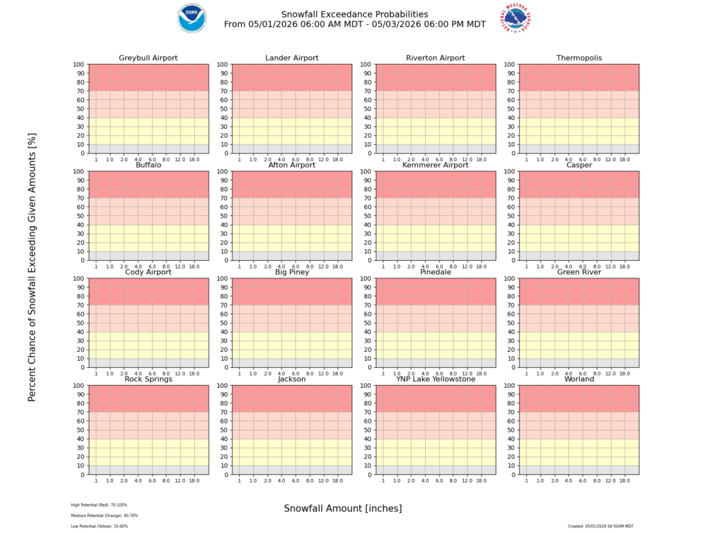
While it won’t see a much snowfall as Colorado in the coming days, Wyoming is bracing for additional accumulations following two winter storms in the past week. Western and Central Wyoming Weather Forecast Office
NWS WFO Riverton
The purpose of these experimental probabilistic snowfall products is to provide customers and partners a range of snowfall possibilities, in complement to existing NWS deterministic snowfall graphics, to better communicate forecast uncertainties during winter weather events. For more information visit this project’s and please provide us your feedback.
Record Freezing Temperatures Incoming
Elsewhere, the East half of the United States is preparing for record cold temperatures.
“Some record low maximum temperatures may be set in the Southern states, with highs in the 40s and 50s in some locations, compared to historical averages in the 70s to near 80” Cold air returns to Midwest, Northeast with frost risk; South faces record-challenging chill surge of chilly air will spread across much of the central and eastern United States, bringing frost risk to some northern areas and unusually cool, conditions that could challenge records in parts of the South. Spring freeze delivers widespread crop losses across mid-Atlantic farms worked through the night ahead of the freeze trying to protect vulnerable crops as temperatures plummeted into the 20s. A late-season freeze this week brought damaging cold to the mid-Atlantic, threatening crops just as orchards and berry fields entered critical stages of growth. Record lows were set in parts of the region from April 20-21, including 24 degrees Fahrenheit in Allentown, Pennsylvania.