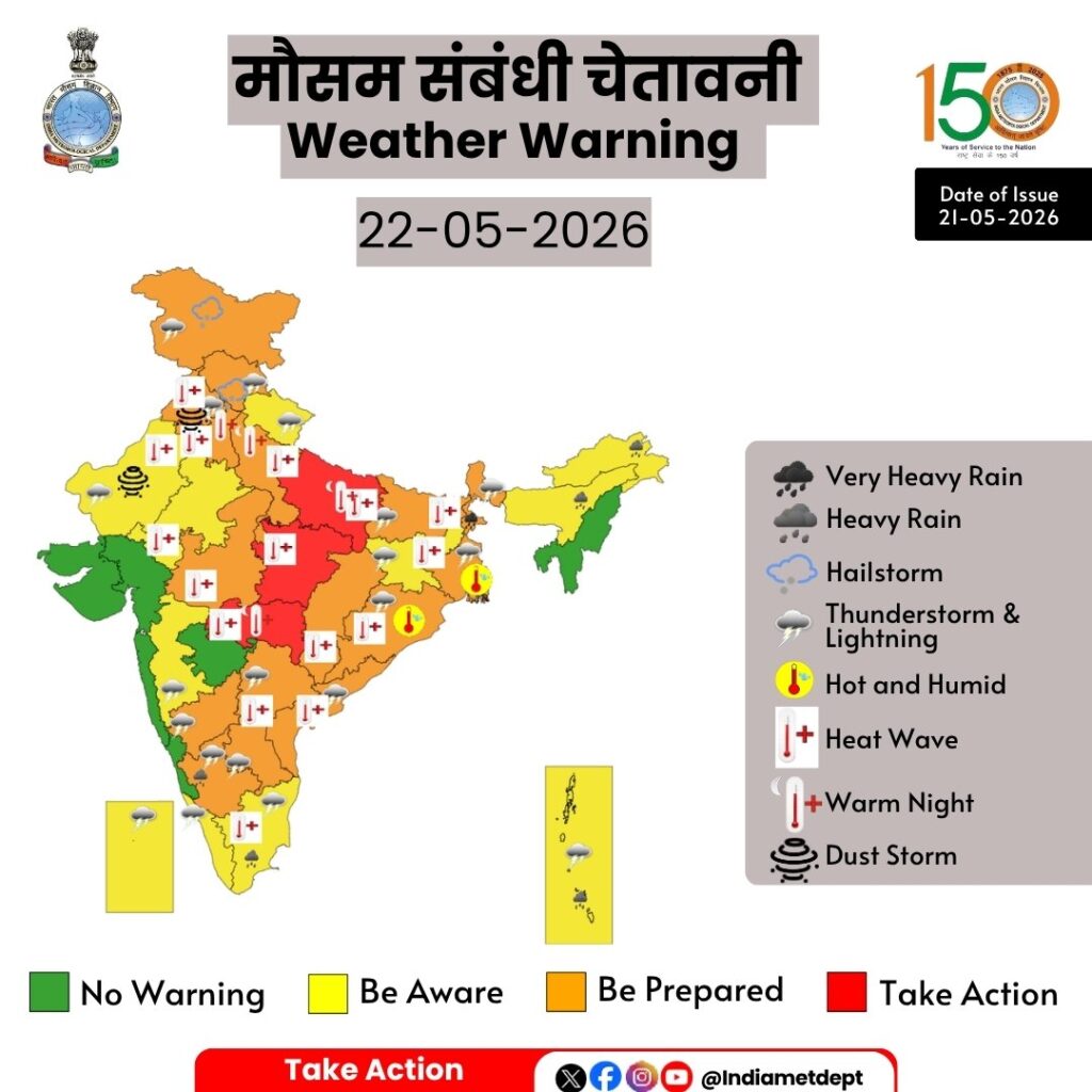
Rain and storms are once again threatening to worsen people’s hardships across the country. According to the Meteorological Department, heavy rain and storms are expected in 16 states, including Uttar Pradesh, Bihar, and Punjab, on May 22nd. Winds of up to 90 kilometers per hour could wreak havoc during this time. Crops in eastern states could be damaged. Be sure to read the weather updates for hilly states. Tomorrow’s weather 22 May 2026: Amidst the intense heat in the country, news of relief has now come. According to the Meteorological Department, a rain and storm warning has been issued for 16 states including Uttar Pradesh and Bihar tomorrow, i.e. on 22 May. During this, strong winds will blow at a speed of 80 to 90 kilometers per hour. At the same time, there is a need to be very cautious in the states of Eastern India. There is a special warning for the people living in the hilly states. Farmers’ crops may get damaged due to heavy rain and storm. A cyclonic circulation is present over Eastern Uttar Pradesh and surrounding areas.

A cyclonic circulation is also forming from northwestern Uttar Pradesh to Manipur. Conditions are developing for the southwest monsoon to advance into the southeast Arabian Sea, the southeast Bay of Bengal, the remaining parts of the Andaman Sea, and some more parts of the east-central Bay of Bengal over the next 3-4 days. So, let’s explore the weather conditions in other states of the country tomorrow, May 22nd. We will also provide district-wise weather forecasts. Rain warning issued in 16 states of the country
According to the Meteorological Department, tomorrow, May 22nd, 16 states including Uttar Pradesh, Bihar, Uttarakhand, Himachal, Jammu and Kashmir, West Bengal, Jharkhand, Odisha, Assam, Andaman and Nicobar Islands, Tamil Nadu, Kerala, Karnataka, Andhra Pradesh, Telangana, and Maharashtra are affected. During this time, storms with speeds of up to 90 kilometers per hour are possible. The Meteorological Department has urged people to be extremely cautious. This rain will provide relief from the heat.
What will the weather be like in Delhi tomorrow?
- Delhi (May 22 – Severe thunderstorms expected): According to the weather department, a severe thunderstorm warning has been issued for Delhi on the evening of May 22nd. Wind speeds could reach 50 to 60 kilometers per hour. The maximum temperature in Delhi on May 22nd is expected to be 43 degrees Celsius, while the minimum temperature is expected to be 31 degrees Celsius.
How will the weather be in UP tomorrow?
- Uttar Pradesh (May 22 – Rain and storm warning): Thunderstorm and rain alerts have been issued for isolated areas in Gorakhpur, Prayagraj, Deoria, Varanasi, Azamgarh, Ballia, Agra, Mathura, Sonbhadra, Bhadohi, Bahraich, and Gonda. Winds can blow at speeds of 50 to 60 kilometers per hour during this period. Meanwhile, the maximum temperature in Lucknow will reach 43 degrees Celsius and the minimum temperature will reach 29 degrees Celsius tomorrow.
How will the weather be in Bihar tomorrow?
- Bihar (May 22 – Heavy rain and storm alert): Heavy rain and storm alerts have been issued for Gaya, Rohtas, Aurangabad, Kaimur, Araria, Supaul, Kishanganj, Darbhanga, Madhubani, Bhagalpur, Purnia, Katihar, Madhepura, Banka, Muzaffarpur, and Sitamarhi. Meanwhile, in Patna, the maximum temperature on May 22 will reach 40 degrees Celsius and the minimum temperature will reach 29 degrees Celsius.
How will the weather be in Jharkhand tomorrow?
- Jharkhand (May 22nd – Heavy rain and storm warning): An alert has been issued for heavy rain and storms in Bokaro, Dhanbad, Ranchi, Deoghar, Giridih, Khunti, Saraikela, Dumka, Jamshedpur, West Singhbhum, East Singhbhum, and Gumla. During this period, winds of up to 70 to 80 kilometers per hour are possible. Meanwhile, in Ranchi, the maximum temperature is expected to reach 39 degrees Celsius and the minimum temperature is expected to reach 26 degrees Celsius tomorrow, May 22nd.
What will the weather be like in West Bengal tomorrow?
- West Bengal (May 22 – Rain and storm alert): Rain and storm warnings are in place for Malda, Durgapur, North 24 Parganas, Cooch Behar, Darjeeling, Kharagpur, Murshidabad, Bankura, Jhargram, Purulia, and North Dinajpur. Meanwhile, on May 22, the maximum temperature in Kolkata will be 37 degrees Celsius and the minimum temperature will be 29 degrees Celsius.
How will the weather be in Uttarakhand tomorrow?
- Uttarakhand (May 22 – Heavy rain and thunderstorm warning): Rain and thunderstorms are likely in Nainital, Bageshwar, Uttarkashi, Rudraprayag, Haridwar, Almora, Rudraprayag, Pithoragarh, Champawat, and Rishikesh. Strong winds with speeds of up to 60 to 70 kilometers per hour are expected during this period. Meanwhile, in Dehradun, the maximum temperature will reach 37 degrees Celsius tomorrow, May 22, and the minimum temperature will drop to 23 degrees Celsius.
| City | Maximum Temperature (May 22) | Minimum temperature (May 22) |
| Delhi | 43°C | 31°C |
| Mumbai | 33°C | 30°C |
| Chennai | 37°C | 30°C |
| Kolkata | 37°C | 29°C |
| Lucknow | 43°C | 29°C |
| Patna | 39°C | 29°C |
| Ranchi | 39°C | 26°C |
| Bhopal | 41°C | 30°C |
| Jaipur | 41°C | 31°C |
| Shimla | 29°C | 18°C |
| Nainital | 31°C | 22°C |
How will the weather be in Himachal tomorrow?
- Himachal Pradesh (May 22 – Rain and Thunderstorm Alert): A warning has been issued for heavy rain and thunderstorms in Solan, Shimla, Kullu, Mandi, Kangra, and Kinnaur. Winds of up to 70 to 75 kilometers per hour are expected during this period. Meanwhile, in Manali, the maximum temperature is expected to reach 9 degrees Celsius and the minimum temperature is expected to reach 2 degrees Celsius tomorrow, May 22.
What will the weather be like in Punjab tomorrow?
- Punjab (May 22 – Rain and thunderstorm warning): A yellow alert for rain and thunderstorms has been issued for Gurdaspur, Patiala, Amritsar, Pathankot, Kapurthala, and Tarn Taran. However, relief from the heat is expected in Punjab starting May 25, with light rain expected to bring temperatures down.
How will the weather be in Rajasthan tomorrow?
- Rajasthan (May 22 – Rain and storm warning): A severe heat alert has been issued for Sriganganagar, Hanumangarh, Churu, Jaisalmer, Jodhpur, Udaipur, Bharatpur, Jhalawar, Banswara, Pratapgarh, and Kota. Strong winds with speeds of 40 to 50 kilometers per hour are likely during this period. Meanwhile, in Jaipur, the maximum temperature on May 22 will reach 41 degrees Celsius and the minimum temperature will reach 31 degrees Celsius.
How will the weather be in Madhya Pradesh tomorrow?
Madhya Pradesh (May 22 – Severe heatwave warning): Ujjain, Khargone, Morena, Sheopur, Rewa, Indore, Balaghat, Jhabua, Shivpuri, Gwalior, Rajgarh, and Shahdol are facing severe heatwave warnings. Meanwhile, in Bhopal, the maximum temperature tomorrow, May 22, will be 41 degrees Celsius and the minimum temperature will be 30 degrees Celsius.
Rain Definition, Causes & Formation Do you know which state in India receives the most rainfall? Learn the scale. Mawsynram, Meghalaya, is the wettest place in India, receiving an average of 11,872 mm of rainfall annually. This village, located in the East Khasi Hills district, is listed in the Guinness Book of World Records. Let’s learn some interesting facts about it. The highest rainfall in India occurs at Mawsynram in the state of Meghalaya. This village, located in the East Khasi Hills district, is considered the rainiest place not only in India but also in the world. Mawsynram is also listed in the Guinness Book of World Records.
Mawsynram receives an average annual rainfall of approximately 11,872 millimeters (mm). For comparison, many large cities in India receive an average of only 700–1,000 mm of rainfall annually. This means that Mawsynram receives 10–15 times more rainfall than a typical Indian city. Why does it rain so heavily?
The primary reason for Mawsynram’s high rainfall is its geographical location. The region lies on the southern slopes of the Khasi Hills and is directly exposed to the southwest monsoon winds blowing from the Bay of Bengal. When these moisture-laden winds collide with the hills, they rise and cause heavy rainfall. This process is called orographic rainfall.
Rainfall is liquid precipitation that falls from the sky as water droplets, formed when atmospheric water vapor condenses. When water from oceans, rivers, and lakes evaporates due to solar heat, it rises, cools down, and forms clouds. Once these droplets become too heavy, gravity pulls them down to the Earth, which we experience as rain.
Based on geographical and atmospheric conditions, rainfall is classified into three main types:
Main Types of Rainfall
- Convective Rainfall: Intense heat warms the air, causing it to rise, cool, and produce heavy showers.
- Orographic Rainfall: Moisture-laden winds strike high mountains, lift upward, and cause rain on the windward side.
- Cyclonic Rainfall: Occurs when two air masses of different temperatures (warm and cold) meet, creating cyclonic activity.
Importance of Rainfall in India
India is an agrarian economy where agriculture heavily depends on the monsoon rains occurring between June and September. The Indian Meteorological Department (IMD) classifies rainfall intensity into ‘light’, ‘moderate’, and ‘heavy’ categories to issue weather forecasts. India Meteorological Department (IMD) has placed 16 states under heavy rain, thunderstorm, and storm alerts. This shifting weather pattern brings intense localized storms to several parts of the country, while severe heatwave conditions simultaneously trigger red alerts in parts of North and Central India. May 22 IMD weather forecast: Heavy rain in Bihar, heat wave in Delhi, red alert for this state | All details
While parts of North India brace for relief with severe thunderstorms and intense winds, the weather department has issued a high-priority red alert for relentless heatwaves across Uttar Pradesh, alongside scorching daytime temperatures in Delhi and heavy rain warnings in Bihar.

22 IMD weather forecast: The intense heat gripping India is finally set to break. The India Meteorological Department (IMD) has issued a major weather alert for May 22, predicting heavy rain, thunderstorms, lightning, and strong winds. After days of punishing heat, changing weather conditions are expected to bring much-needed relief to several states, including Uttar Pradesh, Bihar, Jharkhand, West Bengal, Uttarakhand, and Himachal Pradesh. Here is the full state-wise weather forecast as per the IMD. In total, the IMD has placed 16 states under rain and thunderstorm warnings. This extensive list covers regions from Jammu & Kashmir down to Kerala, Karnataka, Tamil Nadu, Andhra Pradesh, and Telangana, stretching across to Maharashtra, Odisha, and Assam. Weather officials have explicitly warned that some areas could face dangerous, destructive winds blowing between 80 and 90 kmph during these sudden storms. Meanwhile, the national capital, Delhi, will still experience hot weather during the daytime, with temperatures peaking around 43°C and dropping to a minimum of 31°C. However, evening could bring a dramatic shift with strong winds and dust storms reaching speeds of 50 to 60 kmph. Further east, several districts in Bihar, including Gaya, Rohtas, Aurangabad, Kishanganj, Darbhanga, Madhubani, Purnia, Katihar, Bhagalpur, and Muzaffarpur are on high alert for heavy downpours and severe thunderstorms. Vidarbha reels under severe heat wave as IMD issues red alert
The Vidarbha region of Maharashtra is currently reeling under severe heat wave conditions with Wardha recording maximum temperature of 47.1 degrees Celsius on Wednesday and three other cities witnessing the mercury levels breaching the 46 degrees Celsius mark.
The region is unlikely to get any respite from the sweltering heat in next seven days as the India Meteorological Department (IMD) has issued a red alert of severe heat wave conditions in several parts of Vidarbha. The Vidarbha region comprises 11 districts – Akola, Amravati, Bhandara, Buldhana, Chandrapur, Gadchiroli, Gondia, Nagpur, Wardha, Washim and Yavatmal.
Wardha recorded a maximum temperature of 47.1 degrees Celsius, Nagpur 46.6, Amravati 46.4, Chandrapur 46.2, Gadchiroli 45.6, Akola 45.2, Yavatmal 45.2, Bhandara 44.2 and Gondia 44.9 degrees Celsius on Wednesday.
The weather department issued the red alert for Akola, Amravati, Wardha districts on May 21, and orange alert for Nagpur, Chandrapur and Yavatmal for that day. It also issued an orange alert in Amravati, Akola, Wardha, Yavatmal on May 22, 23 and 24.
Red warning for heatwave to severe heatwave conditions over Uttar Pradesh, Madhya Pradesh and Vidarbha for today.
![]() Orange colour warning for Heatwave conditions has been issued over Delhi, Haryana and Chandigarh.
Orange colour warning for Heatwave conditions has been issued over Delhi, Haryana and Chandigarh.
![]() Heatwave conditions also expected over Punjab, Bihar, Chhattisgarh, Jharkhand, Odisha, Rajasthan, Tamil Nadu, Puducherry, Karaikal and Telangana today.
Heatwave conditions also expected over Punjab, Bihar, Chhattisgarh, Jharkhand, Odisha, Rajasthan, Tamil Nadu, Puducherry, Karaikal and Telangana today.
![]() Hot and humid weather over Gangetic West Bengal and Odisha till tomorrow.
Hot and humid weather over Gangetic West Bengal and Odisha till tomorrow.
![]() Warm night conditions are expected over Delhi, Haryana, Chandigarh, Uttar Pradesh and Vidarbha today.
Warm night conditions are expected over Delhi, Haryana, Chandigarh, Uttar Pradesh and Vidarbha today.
![]() Dust Storm at isolated places over Punjab and West Rajasthan today.
Dust Storm at isolated places over Punjab and West Rajasthan today.
![]() Heavy rainfall at parts of North East India, Sub-Himalayan West Bengal and South Interior Karnataka for the day.
Heavy rainfall at parts of North East India, Sub-Himalayan West Bengal and South Interior Karnataka for the day.
![]() Thunderstorms accompanied by lightning and gusty winds expected over Andaman and Nicobar Islands, Himachal Pradesh, Jharkhand, Keralam, Mahe, Lakshadweep, Madhya Maharashtra and Uttarakhand.
Thunderstorms accompanied by lightning and gusty winds expected over Andaman and Nicobar Islands, Himachal Pradesh, Jharkhand, Keralam, Mahe, Lakshadweep, Madhya Maharashtra and Uttarakhand.
![]() Thundersquall accompanied by hailstorm has been predicted for Jammu Kashmir, Ladakh, Gilgit, Baltistan and Muzaffarabad today.
Thundersquall accompanied by hailstorm has been predicted for Jammu Kashmir, Ladakh, Gilgit, Baltistan and Muzaffarabad today.
Key Weather Alert Highlights
- Extreme Wind and Storms: Thundersqualls and severe thunderstorms are tracking across eastern, northeastern, and southern states. Locally, wind speeds are expected to reach between 50–70 kmph, occasionally gusting up to 90 kmph in severely affected pockets.
Subject: (i) Heat wave to severe heat wave conditions likely to continue to prevail over northwest & central India during the week and over East India during next 5 days.
(ii) Isolated heavy rainfall likely over Andaman & Nicobar Islands during the week; and over northeast &
adjoining east India during 21st to 26th May, 2026.
Advance of Southwest Monsoon 2026 (Annexure I):
❖ The Northern Limit of Monsoon continues to pass through 6°N/70°E, 6°N/75°E, 7°N/80°E, 9°N/85°E,
12°N/90°E, 14°N/93°E, 16°N/96°E and 17.5°N/98°E.
❖ Conditions are favourable for further advance of southwest monsoon into some more parts of southeast Arabian Sea, Comorin Area, southwest and southeast Bay of Bengal, remaining parts of Andaman Sea, and some more parts of eastcentral Bay of Bengal during next 3-4 days.
Realised weather during past 24 hours ending at 0830 hours IST of today, the 20th May, 2026:
❖ Heavy rainfall (7-11 cm) has been recorded at isolated places over Tamil Nadu.
❖ Hailstorm reported at isolated places over Telangana, Uttarakhand.
❖ Thunderstorm accompanied with Squally/Gusty winds with speed reaching 80-100 kmph over North Interior Karnataka, Coastal Andhra Pradesh & Yanam; with speed reaching 50-65 kmph over Haryana, Saurashtra Kutch, Odisha, West Uttar Pradesh and with speed reaching 40-50 kmph prevailed at isolated places over Andaman & Nicobar Islands, Jharkhand, Himachal Pradesh, Madhya Maharashtra, Kerala & Mahe.
❖ Heat wave to severe heat wave conditions prevailed in isolated pockets over East Uttar Pradesh; heat wave conditions in few pockets of Punjab, Haryana-Chandigarh-Delhi, West Uttar Pradesh; in isolated pockets over Jammu and Division, Madhya Pradesh and Vidarbha.
❖ Warm Night conditions prevailed at isolated places over East Rajasthan, Odisha.
Temperature Conditions during past 24 hours till 0830 hours IST of today:
❖ Day Temperatures/Maximum Temperatures (as on 19-05-2026): Yesterday, Maximum temperatures are in the range of 40-47°C over northwest India except western Himalayan region, West, Central & adjoining East and North Peninsular India. The highest maximum temperature of 48.2°C was reported at BANDA (UTTAR PRADESH).
❖ Day Temperatures/Maximum Temperature Departures (as on 19-05-2026): Yesterday, Maximum
temperatures are markedly above normal (5.1°C or more) at isolated places over Jammu & Kashmir; Himachal Pradesh, Punjab, Haryana-Chandigarh-Delhi, ; appreciably above normal (3.1°C to 5.0°C) at a few places over Haryana-Chandigarh-Delhi, Punjab, Madhya Maharashtra, Marathwada, Vidarbha; at isolated places over West Madhya Pradesh, East Madhya Pradesh, East Rajasthan, East Uttar Pradesh, Gangetic West Bengal, Gujarat Region, Odisha, Uttarakhand, West Rajasthan, West Uttar Pradesh; above normal (1.6°C to 3.0°C) at many places over Jharkhand; at a few places over Saurashtra & Kutch; at isolated places over Assam & Meghalaya, Coastal Andhra Pradesh & Yanam, Konkan & Goa, South Interior Karnataka, Tamil Nadu, Puducherry & Karaikal, Telangana and Below normal/ near normal over rest parts of the country.
❖ Night Temperatures/Minimum temperatures (as on 20-05-2026) were appreciably above normal (3.1°C to 5.0°C) at a few places over Jammu-Kashmir; above normal (1.6°C to 3.0°C) at many places over Northwest India & Northeast India, Madhya Pradesh, Bihar ,Chhattisgarh , West Bengal, Odisha , Marathawada ,Vidarbha, Coastal Andhra Pradesh & Yanam, Telangana , Rayalaseema and below normal or near normal over rest parts of the country. Weather Systems, Forecast and Warnings (Annexure II & III):
❖ The Western Disturbance as a cyclonic circulation over north Pakistan and adjoining Jammu division persists in lower tropospheric levels.
❖ An upper air cyclonic circulation lies over Punjab & adjoining Pakistan in lower tropospheric levels.
❖ An upper air cyclonic circulation lies over central parts of north Uttar Pradesh in lower tropospheric levels.
❖ A trough from the above cyclonic circulation runs from above central parts of north Uttar Pradesh to north Telangana in lower tropospheric levels.
❖ An upper air cyclonic circulation lies over west Bihar & neighbourhood in lower tropospheric levels.
❖ An upper air cyclonic circulation lies over east Bangladesh & neighbourhood in lower tropospheric levels.
❖ An upper air cyclonic circulation lies over Gangetic West Bengal & adjoining Bangladesh in lower tropospheric levels.
❖ A trough runs from southeast Arabian Sea to the central Bay of Bengal in lower tropospheric levels.
❖ Another Western disturbance seen as a trough in westerlies in middle tropospheric level runs roughly along Long. 52°E to the north of Lat. 30°N.
Under the influence of above systems, the following weather is likely:
Northeast India:
❖ Scattered to Fairly widespread light to moderate rainfall with thunderstorm, lightning & gusty winds (speed reaching 40-50 kmph) likely over Assam & Meghalaya on 23rd & 24th; Nagaland, Manipur, Mizoram & Tripura on 20th & 21st May.
❖ Isolated heavy rainfall likely over Arunachal Pradesh on 22nd, 25th & 26th; Assam & Meghalaya on 21st, 22nd & 26th;
Nagaland, Manipur, Mizoram & Tripura during 22nd – 26th May; with isolated very heavy rainfall over Arunachal Pradesh on 23rd & 24th; Assam & Meghalaya during 23rd-25th May.
❖ Thunderstorm with light to moderate lightning likely over Assam & Meghalaya, on 20th & 21st May.
South Peninsular India:
❖ Fairly widespread to widespread light to moderate rainfall with thunderstorm, lightning & gusty winds (speed reaching 40-50 kmph) likely over Tamil Nadu, Puducherry & Karaikal during 20th – 24th, Kerala & Mahe, Lakshadweep during 20th – 22nd, North Interior Karnataka on 24th, South Interior Karnataka during 22nd – 24th, Rayalaseema, Telangana on 20th & 21st May.
❖ Thundersquall (wind speed reaching 50-60 kmph gusting to 70 kmph) likely over North Interior Karnataka during 20th – 23rd, South Interior Karnataka on 20th & 21st, Coastal Andhra Pradesh & Yanam during 20th – 24th, Rayalaseema during 22nd -24th May.
❖ Isolated Heavy rainfall also likely over Tamil Nadu during 20th -22nd; Kerala & Mahe, South Interior Karnataka on 20th & 21st; Lakshadweep on 20th May.
East India:
❖ Fairly widespread to widespread light to moderate rainfall with thunderstorm, lightning & gusty winds (speed reaching 40-50 kmph) likely over Andaman & Nicobar Islands during 20th-26th; Sub-Himalayan West Bengal & Sikkim during 20th-24rd May.
❖ Isolated to scattered light to moderate rainfall with thunderstorm, lightning & gusty winds (speed reaching 40-50 kmph) likely over Gangetic West Bengal during 21st-23rd; Bihar during 20th-26th; Jharkhand during 21th-26th; Odisha during 22nd – 24th May.
❖ Thundersquall (wind speed reaching 50-60 kmph gusting to 70 kmph) likely over Gangetic West Bengal on 20th; Bihar on 22nd; Jharkhand on 20th, 23rd& 24th; Odisha on 20th & 21st May.
❖ Isolated heavy rainfall likely over Andaman & Nicobar Islands during 20th-22nd and on 25th & 26th; Sub-Himalayan West Bengal & Sikkim on 21st, 25th & 26th May; with very heavy rainfall at a few places over Sub-Himalayan West Bengal & Sikkim on 23rd May; with isolated very heavy rainfall over Sub-Himalayan West Bengal & Sikkim on 22nd & 24th May.
Northwest India:
❖ Isolated to scattered light to moderate rainfall with thunderstorm, lightning & gusty winds (speed reaching
40-50 kmph) likely over Jammu-Kashmir during 20th – 22nd; Himachal Pradesh on 21st & 23rd; Uttarakhand on
22nd & 23rd May.
❖ Thundersquall (wind speed reaching 50-60 kmph gusting to 70 kmph) likely over Jammu-Kashmir on 21st May.
West India:
❖ Isolated light to moderate rainfall with thunderstorm, lightning & gusty winds (speed reaching 40-50 kmph) likely over Konkan & Goa and Madhya Maharashtra on 20th & 21st, Marathawada on 20th May.
Forecast of maximum/day temperatures:
❖ Gradual Fall in maximum temperatures by 2-3°C likely over Maharashtra till 21st and no significant change during 22nd – 26th May.
❖ No significant change in maximum temperatures likely over rest parts of the country till 26th May 2026.
Heat Wave, Hot & Humid weather and Warm Night conditions warning:
❖ Heat wave to severe heat wave conditions very likely in many/some pockets over Punjab; Haryana
Chandigarh & Delhi on 20th & 21st and during 24th – 26th May.
❖ Heat wave to severe heat wave conditions in a few pockets over Vidarbha during 20th – 23rd; Punjab on 22nd & 23rd; West Uttar Pradesh during 20th – 26th; East Uttar Pradesh during 20th – 23rd May.
❖ Heat wave to severe heat wave conditions very likely in isolated/some pockets over Madhya Pradesh during 20th – 25th East Uttar Pradesh during 24th – 26th; Heat wave conditions in isolated pockets over Madhya Pradesh on 26th; Vidarbha during 24th – 26th; Chhattisgarh during 20th – 24th, Coastal Andhra Pradesh & Yanam, Telangana, Odisha during 20th – 24th; Bihar during 20th – 23rd, Rajasthan during 20th – 26th May.
❖ Heat wave conditions very likely in isolated pockets over Jammu-Kashmir, Himachal Pradesh on 20th;
Uttarakhand on 20th & 21st May
❖ Warm Night conditions very likely to prevail in isolated pockets over Odisha during 20th – 24th; Uttar Pradesh, on 21st & 22nd; Vidarbha on 20th & 21st May.
❖ Hot and humid weather conditions likely to prevail over Tamil Nadu, Puducherry & Karaikal during 20th – 23rd; Gangetic West Bengal, Odisha during 20th – 24th May.
Fisherman Warning:
Fishermen are advised not to venture into the following areas:
❖ Bay of Bengal:
Over Gulf of Mannar, adjoining Comorin area, many parts of southwest Bay of Bengal, most parts of southeast Bay of Bengal on 20th May; over many parts of southwest Bay of Bengal, most parts of southeast Bay of Bengal on 21st May; over some parts of southwest Bay of Bengal, many parts of southeast Bay of Bengal on 22nd May; many parts of southwest & southeast Bay of Bengal on 23rd May; over many parts of southwest & southeast Bay of Bengal on 24th May.
Over Gulf of Mannar, adjoining Comorin area 20th to 25th May. Over Andaman Sea during 20th to 23rd May.
❖ Arabian Sea: Along and off Keralam, Karnataka coasts, over Lakshadweep area, adjoining Maldives, over Comorin areas on 20th May; Along and off Keralam coast, over Lakshadweep area, adjoining Maldives, over Comorin areas on 21st May along and of Somalia coast, over many parts of southwest Arabian Sea during 20th to 25th May.
Significant rainfall recorded (in cm) (from 0830 hours IST of yesterday to 0830 hours IST of today):
❖ Tamil Nadu, Puducherry & Karaikal: Varanatapalli (7) Gusty winds (in kmph) (from 0830 hours IST of yesterday to 0830 hours IST of today):
❖ Haryana: Sonipat 61
❖ Saurashtrakutch: Bhachau Amfukutch 57
❖ Odisha: Mayurbhanj 56
❖ West Uttar Pradesh: Agraaws54, Hamirpuraws43, G. B. Nagaraws43, Bulandshaharaws 39, Mathuraaws
39, Agraiaf 37
❖ Andaman & Nicobar Islands: Sri Vijayapuram 50
❖ Jharkhand: Saraikela 50
❖ Himachal Pradesh: Seobagh Amfu48
❖ Madhya Maharashtra : Shahada Nandurbar 44 , Baramati Pune 41 , Kalwan Nashik 37 , Solapur 37
❖ Kerala & Mahe: Palakkad 44, Ernakulam 41.
❖ Gujarat Region: Arnejahmd 43
❖ Gangetic West Bengal: Gangasagar 37
❖ Uttarakhand: Mukteshwar 39, Ranichauri 39, Chamoli 37, Pantnagar 37, Kosiyakutoli 37, Champawat 33, Kashipur 33, Jollygrant 31
❖ Punjab: Hoshiarpur 39
❖ East Uttar Pradesh: Kanpurdehataws 39, Bahraichaws 39
❖ West Madhya Pradesh: Ashoknagar 37 , Sehore 37,Guna 35,Agar 33
❖ Konkan & Goa: Karjat Raigad 37 ,Dapoli Ratnagiri 28
❖ Marathwada: Tondapur Hingoli 35 , Ambejogai Beed 30 ,
❖ Bihar: Sukhet 35
❖ East Madhya Pradesh: Satna 31 , Sagar 30, Shahdol 30
❖ Chattisgarh: Raipur 31, Janjgir 31, Balrampur 31 Annexure I Annexure II
- As the lead period increases forecast accuracy decrease. Annexure III • Action may be taken based on ORANGE AND REDCOLOUR warnings. Vulnerable regions likely urban and hilly areas action may be initiated for heavy rainfall warning. As the lead period increases forecast accuracy decreases.
Past Weather: There has been rise in maximum temperatures up to 1-2°C and no large change in minimum temperatures during past 24 hours over Delhi. The maximum temperatures were found 45-47°C and the minimum temperatures are in the range 27-29°C respectively during past 24 hours over Delhi. The minimum temperatures are above normal (1.6°C to 3.0°C) at a few places and normal (-1.5°C to 1.5°C) at remaining places over Delhi. The maximum temperatures were markedly above normal (5.1°C or more) at few places and appreciably above normal (3.1°C to 5.0°C) at remaining parts over Delhi. Mainly clear sky with westerly winds prevailed with speed 20 kmph gusting to 33 kmph over Delhi during past 24 hours. Mainly clear sky with surface wind speeds up to 20 kmph likely to prevail from west direction over the region in the forenoon today.
Weather Forecast: 20.05.2026: Mainly clear sky. Heat wave conditions at many places with severe heat wave conditions at isolated places. The maximum temperatures over Delhi are likely to be in the range of 45°C to 47°C. The predominant surface wind is likely to be from the west direction with surface wind speed reaching up to 20 kmph during the afternoon hours. The wind speed will increase becoming up to 22 kmph from the west direction during evening and night. 21.05.2026: Mainly clear sky. Heat wave conditions at many places with severe heat wave conditions at isolated places. Sustained strong surface winds speed reaching 15-25 kmph occasionally gusting to 35 kmph during the day. The maximum and minimum temperatures over Delhi are likely to be in the range of 45°C to 47°C and 27°C to 29°C respectively. The minimum temperature will be above normal (1.6°C to 3.0°C) at most places, and maximum temperatures will be markedly above normal (5.1°C or more) at most places over Delhi. The predominant surface wind is likely to be from west direction with surface wind speed reaching up to 20 kmph during the morning hours. The wind speed will be increase becoming up to 22 kmph from the west directionduring afternoon hours. The wind speed will be increase becoming up to 25 kmph from the west direction during evening and night.
22.05.2026: Mainly clear sky. Heat wave conditions at a few places. Sustained strong surface winds speed reaching 15-25 kmph occasionally gusting to 35 kmph during the day. The maximum and minimum temperatures over Delhi are likely to be in the range of 45°C to 47°C and 27°C to 29°C respectively. The minimum temperature will be above normal (1.6°C to 3.0°C) at most places, and the maximum temperature will be markedly above normal (5.1°C or more) over Delhi. The predominant surface wind is likely to be from west direction with surface wind speed reaching up to 20 kmph during the morning hours. The wind speed will be increase becoming up to 25 kmph from the west direction during afternoon hours. The wind speed will be increase becoming up to 20 kmph from the west direction during evening and night.
23.05.2026: Mainly clear sky. Heat wave conditions at a few places. Sustained strong surface winds speed reaching 20-30 kmph occasionally gusting to 40 kmph during the day. The maximum and minimum temperatures over Delhi are likely to be in the range of 44°C to 46°C and 27°C to 29°C respectively. The minimum temperature will be above normal (1.6°C to 3.0°C) at most places, and the maximum temperature will be markedly above normal (5.1°C or more) at many places over Delhi. The predominant surface wind is likely to be from west direction with surface wind speed reaching up to 20 kmph during the morning hours. The wind speed will be increase becoming up to 25 kmph from the west direction during afternoon hours. The wind speed will be increase becoming up to 20 kmph from the west direction during evening and night.
Impact expected and action suggested due to heat wave conditions: - Warning: Heat wave conditions are expected; however, temperatures are likely to remain above
normal. There may be moderate health risks, particularly for vulnerable groups such as infants, the elderly, and individuals with chronic illnesses. - Advisory: Avoid prolonged exposure to heat. Wear lightweight, light-colored, and loose cotton clothing. Cover your head using a cloth, hat, or umbrella when outdoors. Impact expected and action suggested due to isolated thunderstorm with lightning, gusty/squally winds
over
❖ Thundersquall (wind speed reaching 50-60 kmph gusting to 70 kmph) likely over North Interior
Karnataka during 20th – 23rd, South Interior Karnataka on 20th & 21st, Coastal Andhra Pradesh & Yanam during 20th – 24th, Rayalaseema during 22nd -24th, Gangetic West Bengal on 20th; Bihar on 22nd; Jharkhand on 20th, 23rd& 24th; Odisha on 20th & 21st, Jammu-Kashmir on 21st May.
Impact expected:
➢ Breaking of tree branches, uprooting of large avenue trees. Large dead limbs blown from trees.
Damage to Standing crops.
➢ Minor to Major damage to banana and papaya trees.
➢ Minor to major damage to power and communication lines due to breaking of branches.
➢ Strong wind/hail may damage plantation, horticulture and standing crops.
➢ Partial damage to vulnerable structures due to strong winds.
➢ Minor damage to kutcha houses/walls and huts.
➢ Loose objects may fly.
Action suggested:
➢ People are advised to keep a watch on the weather for worsening conditions and be ready to move to safer places accordingly.
➢ Stay indoors, close windows & doors and avoid travel if possible.
➢ Take safe shelters; do not take shelter under trees.
➢ Do not lie on concrete floors and do not lean against concrete walls.
➢ Unplug electrical/ electronic appliances.
➢ Immediately get out of water bodies.
➢ Keep away from all the objects that conduct electricity.
Impact Expected & Action Suggested due to heavy/very heavy rainfall over
❖ Isolated heavy rainfall likely over Arunachal Pradesh on 22nd, 25th & 26th; Assam & Meghalaya on 21st, 22nd & 26th; Nagaland, Manipur, Mizoram & Tripura during 22nd – 26th ; Tamil Nadu during 20th -22nd; Kerala & Mahe, South Interior Karnataka on 20th & 21st; Lakshadweep on 20th ; Andaman & Nicobar Islands during 20th-22nd and on 25th & 26th; Sub-Himalayan West Bengal & Sikkim on 21st, 25th & 26th May; with very heavy rainfall at a few places over Sub-Himalayan West Bengal & Sikkim on 23rd May; with isolated very heavy rainfall over Arunachal Pradesh on 23rd & 24th; Assam & Meghalaya during 23rd-25th ; Sub-Himalayan West Bengal & Sikkim on 22nd & 24th May.
Impact Expected
➢ Localized Flooding of roads, water logging in low lying areas and closure of underpasses mainly in urban areas.
➢ Occasional reduction in visibility due to heavy rainfall.
➢ Disruption of traffic in major cities due to water logging in roads leading to increased travel time.
➢ Minor damage to kutcha roads.
➢ Possibilities of damage to vulnerable structure.
➢ Localized Landslides/Mudslides/landslips/mudslips/landsinks/mudsinks.
➢ Damage to horticulture and standing crops in some areas due to inundation.
➢ It may lead to riverine flooding in some river catchments (for riverine flooding please visit Web page of CWC)
Action Suggested
➢ Check for traffic congestion on your route before leaving for your destination.
➢ Follow any traffic advisories that are issued in this regard.
➢ Avoid going to areas that face the water logging problems often.
➢ Avoid staying in vulnerable structure. Impact expected and action suggested due to Heat wave/ severe heat wave conditions:
❖ Heat wave to severe heat wave conditions likely to continue to prevail over northwest and central India
during the week.
Red alert Areas
➢ Very high likelihood of developing heat illness and heat stroke in all ages.
➢Extreme care needed for vulnerable people.
Orange alert Areas
➢ High temperature & increased likelihood of heat illness symptoms in people who are either
exposed to sun for a prolonged period or doing heavy work.
➢ High health concern for vulnerable people e.g. infants, elderly, people with chronic diseases.
➢ Avoid heat exposure– keep cool. Avoid dehydration.
➢ Drink sufficient water- even if not thirsty.
➢ Use ORS, homemade drinks like lassi, torani (rice water), lemon water, buttermilk, etc. to keep
yourself hydrated.
Yellow alert Areas
➢ Moderate temperature & heat is tolerable for general public but moderate health concern likely for
vulnerable people e.g. infants, elderly, people with chronic diseases.
➢ Avoid heat exposure.
➢ Wear lightweight, light colour, loose, cotton clothes.
➢ Cover your head, use a cloth, hat or umbrella.
Agromet advisories for likely impact of Heavy Rainfall
➢ In Andaman & Nicobar Islands, ensure proper drainage in coconut gardens and avoid water stagnation around basins.
➢ In Sub-Himalayan West Bengal, complete harvesting of rice, maize, mustard and potato. Maintain proper drainage in standing crops.
➢ In Assam and Meghalaya, make necessary arrangements to remove excess rainwater from the crop fields.
➢ In Keralam, provide adequate drainage for banana, coconut, and other vegetables. Provide support to banana plants।
➢ In Tamil Nadu, maintain proper drainage to prevent water stagnation in black gram, green gram,
sugarcane, and vegetable plantations.
➢ In Lakshadweep, postpone irrigation, intercultural operations and application of plant protection
measures & fertilizers to the standing crops. Provide adequate drainage in standing-crop fields to prevent waterlogging.
➢ In South Interior Karnataka, ensure proper drainage in paddy fields, arecanut and mango orchards.
Agromet advisories for likely impact of High temperatures/ Heat Waves
➢ Jammu & Kashmir – apply light and frequent irrigation to the standing crops, use temporary shade nets to
protect the fruit plants from high temperatures.
➢ In Uttarakhand: Provide irrigation to sunflower, fodder maize, tomato, brinjal, etc.
➢ In Punjab, apply light and frequent irrigation to vegetable, moong fruit plants orchards and onion
nurseries.
➢ In Haryana, maintain adequate irrigation in standing sugarcane, cotton and summer fodder crops.
Complete paddy nursery preparation with assured irrigation facilities and adopt mulching/moisture
conservation practices to reduce water stress in newly sown crops
➢ In Uttar Pradesh, provide frequent irrigation and mulching for standing crops such as maize, green gram, black gram, sugarcane, sunflower, vegetables, and fruit plants such as mango, banana, and papaya.
➢ In Rajasthan, apply need-based irrigation to green gram and summer cucurbit crops such as bottle gourd, pumpkin, ridge gourd, cucumber, bitter gourd, and summer ladyfinger, as well as to young fruit plants such as mango, amla, pomegranate, wood apple, and plum. Undertake soil mulching/mulching with straw/polythene to reduce water loss by evaporation.
➢ In Bihar – Apply light and frequent irrigation to the standing crops. Carry out mulching with crop residue, straw or polythene to minimize the loss of soil moisture. Use temporary shade nets to protect the fruit plants from high temperatures.
➢ In Odisha – Provide light irrigation to Boro paddy, summer maize, green gram, black gram, groundnut, and vegetable fields. Ensure adequate soil moisture is maintained in mango and cashew crops.
➢ In Madhya Pradesh, apply light irrigation to maize, moong, urd, groundnut, and vegetable crops as
required.
➢ In Chhattisgarh – Apply light irrigation after weeding and hoeing in rabi maize, banana, and papaya
plantations. Complete harvesting of wheat and chickpea, and ensure safe storage.
➢ In Vidarbha, provide light and frequent irrigation to vegetables and orchards during morning or evening hours, with increased frequency during critical growth stages. Irrigate sugarcane, summer groundnut, vegetables, and orchards as required; use organic or straw mulch in vegetables and orchards; cover banana bunches with leaves; and use shade nets in newly planted banana plantations.
➢ In Telangana – Provide irrigation to mango orchards and vegetable crops, as required.
➢ In Coastal Andhra Pradesh regions experiencing hot and humid conditions, apply light irrigation to
summer crops and vegetables to maintain soil moisture.
➢ Apply mulching to conserve soil moisture in the standing crops.
Agromet advisories for likely impact of Thunderstorm / Gusty Winds
➢ Shift the harvested produce in safer places or cover the produce with tarpaulin sheets in the fields. Tie the harvested crops securely and cover them to minimize the risk of displacement from strong surface winds.
➢ Provide mechanical support to horticultural crops and staking or support to vegetables and young fruit plants / fruit-bearing plants to avoid lodging due to strong winds.
Livestock / Poultry / Fisheries
➢ Keep the animals inside the shed during hailstorms/ heavy rainfall and provide them with balanced feed.
➢ Store feed and fodder in a safe place to prevent spoilage.
➢ Construct an outlet with proper netting around the ponds to drain excess water, thereby preventing fish from escaping in the event of overflow.
➢ In regions with high temperatures and heat waves, provide clean, hygienic, and ample drinking water for animals, and cover the roofs of poultry sheds with grass to reduce the adverse effects.
➢ Coastal states (especially Tamil Nadu, Kerala and Lakshadweep), fishermen are advised not to venture into sea.
Legends & abbreviations:
❖ Heavy Rain:64.5115.5mm; Very Heavy Rain:115.6204.4mm; Extremely Heavy Rain: >204.4mm.
❖ Obsy: Observatory; Automatic Weather Station; ARG: Automatic Rain Gauge; dist: District: NH: National
Highway; KVK: Krishi Vigyan Kendra; DVC: Damodar Valley Corporation; PTO: Part Time Office, Aero:
Aerodrome, IAF: Indian Air Force.
❖ Region wise classification of meteorological Sub-Divisions:
- Northwest India: Western Himalayan Region (Jammu-Kashmir-Ladakh-Gilgit-Baltistan-Muzaffarabad, Himachal Pradesh and Uttarakhand); Punjab, Haryana Chandigarh & Delhi; West Uttar Pradesh, East Uttar Pradesh, West Rajasthan and East Rajasthan.
- Central India: West Madhya Pradesh, East Madhya Pradesh, Vidarbha and Chhattisgarh.
- East India: Bihar, Jharkhand, Sub-Himalayan West Bengal & Sikkim; Gangetic West Bengal, Odisha and Andaman & Nicobar Islands.
- Northeast India: Arunachal Pradesh, Assam & Meghalaya and Nagaland, Manipur, Mizoram & Tripura.
- West India: Gujarat Region, Saurashtra & Kutch, Coastal Maharashtra (Konkan) & Goa, Madhya
Maharashtra and Marathawada. - South India: Coastal Andhra Pradesh & Yanam, Telangana, Rayalaseema, Coastal Karnataka, North Interior Karnataka, South Interior Karnataka, Kerala & Mahe, Tamil Nadu, Puducherry & Karaikal and Lakshadweep.
Heavy Rainfall Zones: Heavy to very heavy downpours are concentrated across Sub-Himalayan West Bengal, Sikkim, and Northeastern states (Assam, Meghalaya, and Arunachal Pradesh).
ALL INDIA WEATHER SUMMARY AND FORECAST BULLETIN
Significant Weather Features
Advance of Southwest Monsoon 2026:
The Northern Limit of Monsoon continues to pass through 6°N/70°E, 6°N/75°E, 7°N/80°E , 9°N/85°E,
12°N/90°E , 14°N/93°E , 16°N/96°E and 17.5°N/98°E .
Conditions are favourable for further advance of southwest monsoon into some more parts of southeast Arabian Sea, Comorin Area, southwest and southeast Bay of Bengal, remaining parts of Andaman Sea, and some more parts of eastcentral Bay of Bengal during next 2-3 days.
Weather Forecast & warnings
Northeast India:
Fairly widespread to widespread light to moderate rainfall with thunderstorm, lightning & gusty
winds (speed reaching 40-50 kmph) likely over Assam & Meghalaya on 22nd & 23rd and Nagaland, Manipur and Mizoram on 22nd May.
Isolated heavy rainfall likely over Arunachal Pradesh during 22nd-27th; Assam & Meghalaya during 22nd-28th and Nagaland, Manipur, Mizoram & Tripura during 22nd-24th May with isolated very heavy rainfall also likelyover Arunachal Pradesh on 23rd & 24th; Assam & Meghalaya during 23rd-25th May.
South Peninsular India: Widespread light to moderate rainfall with thunderstorm, lightning & gusty winds (speed reaching 40-50 kmph) likely over Kerala & Mahe and Lakshadweepduring 22nd-26thMay. Isolated to scattered light to moderate rainfall with thunderstorm, lightning & gusty winds (speed reaching 40-50 kmph)likely over Tamil Nadu, Puducherry & Karaikal, Interior Karnataka, Coastal Andhra Pradesh & Yanam, Rayalaseema and Telangana during 22nd-26thMay.
Thundersquall (wind speed reaching 50-60 kmph gusting to 70 kmph) likely over Interior Karnataka,
Coastal Andhra Pradesh & Yanam and Rayalaseema on 22nd & 23rd May.
Isolated Heavy rainfall also likely over Tamil Nadu & Lakshadweep during 22nd-26th; Kerala & Mahe during 22nd-28th; North Interior Karnataka & Rayalaseema on 22nd & 23rd; South Interior Karnataka during 22nd-24th May. Isolated Hailstorm activity likely over North Interior Karnataka on 22nd May.
East India:
Fairly widespread to widespread light to moderate rainfall with thunderstorm, lightning & gusty
winds (speed reaching 40-50 kmph) likely over Andaman & Nicobar Islands during 22nd-28th; Sub-Himalayan West Bengal & Sikkim during 22nd -24th May. Isolated to scattered light to moderate rainfall with thunderstorm, lightning & gusty winds (speed reaching 40-50 kmph) likely over Gangetic West Bengal, Bihar & Jharkhand during 22nd-28th; Odisha during 22nd-26th May. Thunderbolt (wind speed reaching 50-60 kmph gusting to 70 kmph) likely over Gangetic West Bengal & Odisha on 22nd; Jharkhand on 24th & 25th; Bihar on 25th May.
Isolated heavy rainfall likely over Sub-Himalayan West Bengal & Sikkim during 22nd-26th; Bihar on 25th May; with isolated very heavy rainfall over Sub-Himalayan West Bengal & Sikkim on 22nd & 23rd May.
IsolatedHailstormactivity likely over Odisha on 22nd May.
Northwest India:
Scattered to fairly widespread light to moderate rainfall with thunderstorm, lightning & gusty winds (speed reaching 40-50 kmph) likely over Jammu-Kashmir during 22nd-25th; Himachal Pradesh and Uttarakhand on 22nd & 23rd May. Isolated light to moderate rainfall with thunderstorm, lightning & gusty winds (speed reaching 40-50 kmph)likely over Punjab on 22nd & 23rd; Haryana & Chandigarh and West Rajasthan on 22nd May.
IsolatedHailstormactivity likely over Uttarakhand on 22nd, Himachal Pradesh on 22nd & 23rd May.
Dust storm activity likely at isolated places over West Rajasthan on 22nd May.
West India:
Isolated light to moderate rainfall with thunderstorm, lightning & gusty winds (speed reaching 40-50
kmph)likely over Konkan & Goa, Madhya Maharashtra and Marathawadaon 22nd & 23rd May.
Forecast of maximum/day temperatures:
No significant change in maximum temperatures likely over East India till 26th May and gradual fall by 2-3°C on 27th & 28th May. No significant change in maximum temperatures likely over the rest parts of country till 28th May 2026.
Heat Wave, Hot & Humid weather and Warm Night conditions warning:
Heat wave conditions very likely in isolated/some pockets over Uttar Pradesh and Madhya Pradesh during 22nd-28th May with severe heat wave conditions over East Uttar Pradesh and East Madhya Pradesh during same period.
Heat wave conditions very likely in isolated/some pockets over Punjab and Haryana, Chandigarh & Delhi during 22nd-28th May with severe heat wave conditions likely in some/many pockets during 24th-27th May. Heat wave conditions very likely in isolated/some pockets over Rajasthan during 22nd-28th May with severe heat wave conditions likely in isolated/some pockets over West Rajasthan during 24th-28th May.
Heat wave conditions very likely in isolated pockets over Vidarbha during 22nd-28th May with severe heatwave conditions likely in isolated pockets during 22nd-26th May.`
Heat wave conditions very likely in isolated pockets over Coastal Andhra Pradesh & Yanam during 22nd-26th May with severe heat wave conditions likely in isolated pockets during 22nd-24th May.
Heat wave conditions very likely in isolated pockets over Bihar during 22nd-24th; Tamil Nadu on 22nd;
Chhattisgarh, Jharkhand, Odisha & Telangana during 22nd-26th; Jammu-Kashmir, Himachal Pradesh &
Uttarakhand during 26th-28th May. Hot and humid weather conditions likely to prevail over Gangetic West Bengal during 22nd-26th; Tamil Nadu on 23rd May. Warm Night conditions very likely to prevail in isolated pockets over Uttar Pradesh, Vidarbha during 22nd-24th; Odisha during 22nd-26th and Telangana on 22nd & 23rd May.
Main Weather Observations:
❖ Rainfall distribution (from 0830 hours IST of yesterday to 0830 hours IST of today): at most places over Jammu-KashmirLadakh-Gilgit-Baltistan-Muzaffarabad and Rayalaseema; at many places over Andaman & Nicobar Islands, South Interior Karnataka and Kerala & Mahe; at a few places over Assam & Meghalaya, Nagaland, Manipur, Mizoram & Tripura, Sub Himalayan West Bengal & Sikkim, Himachal Pradesh, Coastal Karnataka, North Interior Karnataka and Lakshadweep; at isolated places over Arunachal Pradesh, Gangetic West Bengal, Odisha, Jharkhand, Bihar, Uttarakhand, Punjab, Konkan & Goa, Marathwada, Coastal Andhra Pradesh & Yanam, Telangana and Tamil Nadu, Puducherry & Karaikal; Dry over rest of the country.
❖ Significant rainfall recorded(in cm) (from 0830 hours IST of yesterday to 0830 hours IST of today): Kerala & Mahe: Mavelikara (dist Alapuzha) 23; Kayamkulam ARG (dist Alapuzha) 21; Kayamkulam (dist Alapuzha) 13; Mancompu (dist Alapuzha), Nooranad AWS (dist Alapuzha) 12 Each; Haripad (dist Alapuzha), Karumadi AWS (distAlapuzha) 10 Each; Tellichery (dist Cannur), Cherthala (dist Alapuzha), Paripalli AWS (dist Kollam) 9 Each; Vaikkom AWS (dist Kottayam) 8; Kozhikode (dist Kozhikode) 7; Kollam Rly (dist Kollam) 6; South Interior Karnataka: Y N Hoskote (dist Tumakuru) 9; Bengaluru City (dist Bengaluru Urban) 6; Bihar: Jhanjharpur (dist Madhubani) 9; Lakhnaur (dist Madhubani) 7; Assam & Meghalaya: SCS College of agriculture (dist Dhubri) 15, Bahalpur (dist Dhubri) 8; TamilNadu: Hosur AWS (Krishnagiri) 7; Rayalaseema: Anantpur (dist Anantapuramu) 7; Sub Himalayan West Bengal & Sikkim: Sankos Tea Estate (dist Alipurduar) 7; Nagaland, Manipur, Mizoram & Tripura: Khumluwang ARG (distWest Tripura) 6.
❖ Heavy Rainfall observed (from 0830 hours IST of yesterday to 0830 hours IST of today):Extremely heavy rain at isolated places over Kerala & Mahe. Heavy to very heavy rain at isolated places over Assam. Heavy rain at isolated places over Sub Himalayan West Bengal & Sikkim, Bihar, Rayalaseema, Tamilnadu and South Interior Karnataka.
❖ Hailstorm occurred at isolated places over South Interior Karnataka.
❖ Thunderstorm accompanied with Squally/Gusty winds with speed reaching 80-120 kmph prevailed at isolated places over Assam & Meghalaya & South Interior Karnataka; with speed reaching 50-80 kmph prevailed at isolated places over Marathawada, Bihar, Odisha, Tamil Nadu andwith speed reaching 40-50 kmph prevailed at isolated places over Madhya Maharashtra, Coastal Andhra Pradesh, Kutch, Madhya Pradesh, Uttar Pradesh, Jammu-Kashmir, Punjab and Haryana.
❖ Heat wave to severe heat wave conditions prevailed in few pockets over East Uttar Pradesh & Vidarbha; heat wave conditions in many pockets of Haryana Chandigarh & Delhi and Himachal Pradesh; some pockets of East Madhya Pradesh; in isolated pockets of Uttarakhand, Punjab, West Uttar Pradesh, Chhattisgarh & Coastal Andhra Pradesh.
❖ Warn night conditions prevailed in isolated pockets over Punjab, Uttar Pradesh, East Madhya Pradesh, Vidarbha.
❖ Minimum Temperature Departures (as on 22-05-2026): markedly above normal(> 5.1°C) at many places over Vidarbha; at most places over Himachal Pradesh; at few places over West Madhya Pradesh and East Madhya Pradesh; at isolated places over Assam & Meghalaya, Gangetic West Bengal, Odisha, Bihar, East Uttar Pradesh, West Uttar Pradesh, Jammu-KashmirLadakh-Gilgit-Baltistan-Muzaffarabad, Gujarat Region, Saurashtra & Kutch and Coastal Andhra Pradesh & Yanam. appreciably above normal(3.1°C to 5.0°C) at few places over Jharkhand, Uttarakhand, Punjab, Vidarbha and Coastal Andhra Pradesh & Yanam; at isolated places over Nagaland, Manipur, Mizoram & Tripura, Sub Himalayan West Bengal & Sikkim, Haryana-Chandigarh-Delhi, West Madhya Pradesh, Saurashtra & Kutch, Konkan & Goa, Madhya Maharashtra, Chhattisgarh, Telangana, Rayalaseema and Tamil Nadu, Puducherry & Karaikal. above normal(1.6°C to 3.0°C) at most places over Arunachal Pradesh and Marathwada; at few places over Andaman & Nicobar Islands, West Rajasthan, East Rajasthan, Gujarat Region, Madhya Maharashtra, Coastal Andhra Pradesh & Yanam, Telangana and Tamil Nadu, Puducherry & Karaikal; at isolated places over West Madhya Pradesh, Chhattisgarh, Rayalaseema, North Interior Karnataka and South Interior Karnataka. near normal(-1.5°C to 1.5°C) at many places over East Rajasthan, East Madhya Pradesh, Gujarat Region, Saurashtra & Kutch, Chhattisgarh and North Interior Karnataka; at most places over Konkan & Goa, Coastal Karnataka, Kerala & Mahe and Lakshadweep; at few places over West Madhya Pradesh, Madhya Maharashtra, Telangana, Tamil Nadu, Puducherry & Karaikal and South Interior Karnataka; at isolated places over Coastal Andhra Pradesh & Yanam and Rayalaseema. The lowest minimum temperature of 19.0°C was reported at HALFLONG (ASSAM), and DAVANAGERE (KARNATAKA) over the Plains of India.
❖ Maximum Temperature Departures (as on 21-05-2026): markedly above normal(> 5.1°C) at many places over East Uttar Pradesh, Himachal Pradesh, Coastal Andhra Pradesh & Yanam and Telangana; at most places over West Uttar Pradesh, East Madhya Pradesh and Chhattisgarh; at few places over West Madhya Pradesh; at isolated places over East Rajasthan, Vidarbha and Tamil Nadu, Puducherry & Karaikal. appreciably above normal(3.1°C to 5.0°C) at many places over Marathwada; at few places over Rayalaseema; at isolated places over Gujarat Region, Saurashtra & Kutch, Konkan & Goa and North Interior Karnataka. above normal(1.6°C to 3.0°C) at isolated places over Madhya Maharashtra. near normal(-1.5°C to 1.5°C) at most places over Coastal Karnataka, South Interior Karnataka, Kerala & Mahe and Lakshadweep. The highest maximum temperature of 47.6°C was reported at BANDA (UTTAR PRADESH).
Meteorological Analysis (Based on 1430 hours IST)
The Northern Limit of Monsoon continues to pass through 6°N/70°E, 6°N/75°E, 7°N/80°E , 9°N/85°E,
12°N/90°E , 14°N/93°E , 16°N/96°E and 17.5°N/98°E .
Conditions are favourable for further advance of southwest monsoon into some more parts of southeast Arabian Sea, Comorin Area, southwest and southeast Bay of Bengal, remaining parts of Andaman Sea, and some more parts of eastcentral Bay of Bengal during next 2-3 days. The Western Disturbance as a cyclonic circulation over north Pakistan & neighbourhood at 3.1 km above mean sea level with a trough aloft in middle and upper tropospheric westerlies with its axis at 5.8 km above mean sea level roughly along Long. 71°E to the north of Lat. 28°N persists.The upper air cyclonic circulation over northwest Uttar Pradesh & neighbourhood extending upto 1.5 km above mean sea level persists. The upper air cyclonic circulation over interior Odisha & neighbourhood extending upto 1.5 km above mean sea level persists.
The trough from the upper air cyclonic circulation over northwest Uttar Pradesh to the upper air cyclonic circulation over interior Odisha across East Uttar Pradesh and Chhattisgarh extending upto 1.5 km above mean sea level persists.
The upper air cyclonic circulation over central Assam & neighbourhood at 1.5 km above mean sea level
persists. The upper air cyclonic circulation over Southeast Bay of Bengal & neighbourhood at 3.1 km above mean sea level persists.
The trough from the upper air cyclonic circulation over Southeast Bay of Bengal to north Kerala across
Southwest Bay of Bengal and Tamilnadu at 3.1 km above mean sea level persists.
The upper air cyclonic circulation over eastcentral Arabian Sea & neighbourhood extending upto 1.5 km
above mean sea level persists.
The upper air cyclonic circulation over southeast Arabian Sea & neighbourhood at 3.1 km above mean sea level persists.
The trough from the upper air cyclonic circulation over Southeast Arabian Sea to Comorin area across
Kerala and south Tamil Nadu at 3.1 km above mean sea level persists.
22 May (Day 1)
❖ Heavy to Very Heavy Rainfall very likely at isolated places over Kerala & Mahe and Sub Himalayan West Bengal & Sikkim.
❖ Heavy Rainfall very likely at isolated places over Arunachal Pradesh, Assam & Meghalaya, Interior Karnataka, Lakshadweep, Nagaland, Manipur, Mizoram and Tripura, Rayalaseema and Tamil Nadu Puducherry & Karaikal.
❖ Thunderstorm accompanied with Hailstorm very likely at isolated places over Himachal Pradesh, North Interior Karnataka, Odisha and Uttarakhand.
❖ Thundersquall with wind speed reaching(50-60kmph) very likely at isolated places over Andhra Pradesh,Gangetic West Bengal, Interior Karnataka and Odisha.
❖ Thunderstorm accompanied with lightning & gusty winds(40-50kmph) very likely at isolated places over Andaman & Nicobar Islands, Assam & Meghalaya, Bihar, Haryana, Chandigarh & Delhi, Himachal Pradesh, Jammu-Kashmir-Ladakh-Gilgit-Baltistan-Muzaffarabad, Jharkhand, Kerala & Mahe, Konkan & Goa, Lakshadweep, Madhya Maharashtra, Marathwada, Nagaland, Manipur, Mizoram and Tripura, Punjab, Sub Himalayan West Bengal & Sikkim, Tamil Nadu Puducherry & Karaikal, Telangana, Uttarakhand and West Rajasthan.
❖ Thunderstorm accompanied with lightning & gusty winds(30-40kmph) very likely at isolated places over Arunachal Pradesh.
❖ Thunderstorm accompanied with Lightning very likely at isolated places over Coastal Karnataka.
❖ Dust Storm very likely at isolated places over West Rajasthan.
❖ Heat Wave conditions very likely at isolated places over Bihar, Chhattisgarh, Coastal Andhra Pradesh, Haryana, Chandigarh & Delhi, Jharkhand, Odisha, Punjab, Rajasthan, Tamil Nadu Puducherry & Karaikal, Telangana, West Madhya Pradesh and West Uttar Pradesh.
❖ Heat Wave to Severe Heat Wave conditions very likely at isolated places over East Madhya Pradesh, East Uttar Pradesh and Vidarbha.
❖ Hot and Humid weather very likely at isolated places over Gangetic West Bengal.
❖ Warm Night conditions very likely at isolated places over Telangana, Uttar Pradesh and Vidarbha.
❖ Arabian Sea: Squally Weather with wind speed 40-50 kmph gusting to 60 kmph is likely to prevail along and off Keralam, Karnataka coasts, Lakshadweep, Maldives, Comorin areas, over most parts of southeast Arabian Sea, adjoining parts of southwest & westcentral Arabian Sea.
❖ Squally wind with speed 45-55 kmph gusting to 65 kmph is likely to prevail along and off Somalia coast, adjoining some parts of southwest Arabian Sea.
❖ Bay of Bengal: Squally Weather with wind speed 40-50 kmph gusting to 60 kmph is likely to prevail over Gulf of Mannar, most parts of south Bay of Bengal, over south and adjoining north Andaman Sea.
23 May (Day 2)
❖ Heavy to Very Heavy Rainfall very likely at isolated places over Arunachal Pradesh, Assam & Meghalaya and
Sub Himalayan West Bengal & Sikkim.
❖ Heavy Rainfall very likely at isolated places over Interior Karnataka, Kerala & Mahe, Lakshadweep, Nagaland, Manipur, Mizoram and Tripura, Rayalaseema and Tamil Nadu Puducherry & Karaikal.
❖ Thunderstorm accompanied with Hailstorm very likely at isolated places over Himachal Pradesh.
❖ Thundersquall with wind speed reaching(50-60kmph) very likely at isolated places over Andhra Pradesh and Interior Karnataka.
❖ Thunderstorm accompanied with lightning & gusty winds(40-50kmph) very likely at isolated places over Andaman & Nicobar Islands, Assam & Meghalaya, Bihar, Himachal Pradesh, Jammu-Kashmir-Ladakh-Gilgit-Baltistan-Muzaffarabad, Jharkhand, Kerala & Mahe, Konkan & Goa, Lakshadweep, Madhya Maharashtra, Marathwada, Odisha, Punjab, Tamil Nadu Puducherry & Karaikal, Telangana, Uttarakhand and West Bengal & Sikkim.
❖ Thunderstorm accompanied with lightning & gusty winds(30-40kmph) very likely at isolated places over Arunachal Pradesh.
❖ Thunderstorm accompanied with Lightning very likely at isolated places over Coastal Karnataka and
Nagaland, Manipur, Mizoram and Tripura.
❖ Heat Wave conditions very likely at isolated places over Bihar, Chhattisgarh, Coastal Andhra Pradesh, Haryana, Chandigarh & Delhi, Jharkhand, Odisha, Punjab, Rajasthan, Telangana, West Madhya Pradesh and West Uttar Pradesh.
❖ Heat Wave to Severe Heat Wave conditions very likely at isolated places over East Madhya Pradesh, East Uttar
Pradesh and Vidarbha.
❖ Hot and Humid weather very likely at isolated places over Gangetic West Bengal and Tamil Nadu Puducherry & Karaikal.
❖ Warm Night conditions very likely at isolated places over Odisha, Telangana, Uttar Pradesh and Vidarbha.
❖ Arabian Sea: Squally Weather with wind speed 40-50 kmph gusting to 60 kmph is likely to prevail along and off Keralam, Karnataka coasts, Lakshadweep, Maldives, Comorin areas, over most parts of southeast Arabian Sea.
❖ Squally wind with speed 45-55 kmph gusting to 65 kmph is likely to prevail over along and off Somalia coast, adjoining some parts of southwest Arabian Sea.
❖ Bay of Bengal: Squally Weather with wind speed 40-50 kmph gusting to 60 kmph is likely to prevail over Gulf of Mannar, most parts of south Bay of Bengal.
24 May (Day 3)
❖ Heavy to Very Heavy Rainfall very likely at isolated places over Arunachal Pradesh and Assam & Meghalaya.
❖ Heavy Rainfall very likely at isolated places over Kerala & Mahe, Lakshadweep, Nagaland, Manipur, Mizoram and Tripura, South Interior Karnataka, Sub Himalayan West Bengal & Sikkim and Tamil Nadu Puducherry & Karaikal.
❖ Thundersquall with wind speed reaching(50-60kmph) very likely at isolated places over Jharkhand.
❖ Thunderstorm accompanied with lightning & gusty winds(40-50kmph) very likely at isolated places over Andaman & Nicobar Islands, Andhra Pradesh, Bihar, Interior Karnataka, Jammu-Kashmir-Ladakh-Gilgit-Baltistan- Muzaffarabad, Kerala & Mahe, Lakshadweep, Odisha, Sub Himalayan West Bengal & Sikkim and Tamil Nadu Puducherry & Karaikal.
❖ Thunderstorm accompanied with lightning & gusty winds(30-40kmph) very likely at isolated places over Arunachal Pradesh, Assam & Meghalaya and Gangetic West Bengal.
❖ Thunderstorm accompanied with Lightning very likely at isolated places over Coastal Karnataka and
Nagaland, Manipur, Mizoram and Tripura.
❖ Heat Wave conditions very likely at isolated places over Bihar, Chhattisgarh, Coastal Andhra Pradesh, East Rajasthan, Jharkhand, Odisha, Telangana, West Madhya Pradesh and West Uttar Pradesh.
❖ Heat Wave to Severe Heat Wave conditions very likely at isolated places over East Madhya Pradesh, East Uttar Pradesh, Haryana, Chandigarh & Delhi, Punjab, Vidarbha and West Rajasthan.
❖ Hot and Humid weather very likely at isolated places over Gangetic West Bengal.
❖ Warm Night conditions very likely at isolated places over Odisha, Uttar Pradesh and Vidarbha.
❖ Arabian Sea: Squally Weather with wind speed 40-50 kmph gusting to 60 kmph is likely to prevail along and off Keralam, Karnataka coasts, Lakshadweep, Comorin areas, adjoining Maldives area.
❖ Squally wind with speed 45-55 kmph gusting to 65 kmph is likely to prevail over along and off Somalia coast, adjoining some parts of southwest Arabian Sea.
❖ Bay of Bengal: Squally Weather with wind speed 40-50 kmph gusting to 60 kmph is likely to prevail over Gulf of Mannar, many parts of south Bay of Bengal.
❖ Squally wind with speed 45-55 kmph gusting to 65 kmph is likely to prevail over few parts of southwest Bay of Bengal.
25 May (Day 4)
❖ Heavy to Very Heavy Rainfall likely at isolated places over Assam & Meghalaya.
❖ Heavy Rainfall likely at isolated places over Arunachal Pradesh, Bihar, Kerala & Mahe, Lakshadweep, Sub Himalayan West Bengal & Sikkim and Tamil Nadu Puducherry & Karaikal.
❖ Thundersquall with wind speed reaching(50-60kmph) likely at isolated places over Bihar and Jharkhand.
❖ Thunderstorm accompanied with lightning & gusty winds(40-50kmph) likely at isolated places over Andaman & Nicobar Islands, Andhra Pradesh, Interior Karnataka, Jammu-Kashmir-Ladakh-Gilgit-Baltistan-Muzaffarabad, Kerala & Mahe, Lakshadweep, Odisha and Tamil Nadu Puducherry & Karaikal.
❖ Thunderstorm accompanied with lightning & gusty winds(30-40kmph) likely at isolated places over Gangetic West Bengal.
❖ Thunderstorm accompanied with Lightning likely at isolated places over Arunachal Pradesh, Assam & Meghalaya, Coastal Karnataka, Nagaland, Manipur, Mizoram and Tripura and Sub Himalayan West Bengal & Sikkim.
❖ Heat Wave conditions likely at isolated places over Chhattisgarh, Coastal Andhra Pradesh, East Rajasthan, Jharkhand, Odisha, Telangana, West Madhya Pradesh and West Uttar Pradesh.
❖ Heat Wave to Severe Heat Wave conditions likely at isolated places over East Madhya Pradesh, East Uttar Pradesh, Haryana, Chandigarh & Delhi, Punjab, Vidarbha and West Rajasthan.
❖ Hot and Humid weather likely at isolated places over Gangetic West Bengal.
❖ Warm Night conditions likely at isolated places over Odisha.
❖ Arabian Sea: Squally Weather with wind speed 40-50 kmph gusting to 60 kmph is likely to prevail along and off Keralam, Karnataka coasts, Lakshadweep, Comorin areas, adjoining Maldives area.
❖ Squally wind with speed 45-55 kmph gusting to 65 kmph is likely to prevail along and off Somalia coast, adjoining some parts of southwest Arabian Sea.
❖ Bay of Bengal: Squally Weather with wind speed 40-50 kmph gusting to 60 kmph is likely to prevail over many parts of south Bay of Bengal.
❖ Squally wind with speed 45-55 kmph gusting to 65 kmph is likely to prevail over some parts of southwest Bay of Bengal.
26 May (Day 5)
❖ Heavy Rainfall likely at isolated places over Arunachal Pradesh, Assam & Meghalaya, Kerala & Mahe,
Lakshadweep, Sub Himalayan West Bengal & Sikkim and Tamil Nadu Puducherry & Karaikal.
❖ Thunderstorm accompanied with lightning & gusty winds(40-50kmph) likely at isolated places over Andaman & Nicobar Islands, Andhra Pradesh, Bihar, Interior Karnataka, Jharkhand, Kerala & Mahe, Lakshadweep, Odisha and Tamil Nadu Puducherry & Karaikal.
❖ Thunderstorm accompanied with lightning & gusty winds(30-40kmph) likely at isolated places over Gangetic West Bengal.
❖ Thunderstorm accompanied with Lightning likely at isolated places over Arunachal Pradesh, Assam & Meghalaya, Coastal Karnataka, Nagaland, Manipur, Mizoram and Tripura and Sub Himalayan West Bengal & Sikkim.
❖ Heat Wave conditions likely at isolated places over Chhattisgarh, Coastal Andhra Pradesh, East Rajasthan, Himachal Pradesh, Jammu-Kashmir-Ladakh-Gilgit-Baltistan-Muzaffarabad, Jharkhand, Odisha, Telangana,
Uttarakhand, West Madhya Pradesh and West Uttar Pradesh.
❖ Heat Wave to Severe Heat Wave conditions likely at isolated places over East Madhya Pradesh, East Uttar Pradesh, Haryana, Chandigarh & Delhi, Punjab, Vidarbha and West Rajasthan.
❖ Hot and Humid weather likely at isolated places over Gangetic West Bengal.
❖ Warm Night conditions likely at isolated places over Odisha.
❖ Squally Weather with wind speed 40-50 kmph gusting to 60 kmph is likely to prevail along and off Keralam, Karnataka coasts, Lakshadweep, Comorin areas, adjoining Maldives area.
❖ Squally wind with speed 45-55 kmph gusting to 65 kmph is likely to prevail along and off Somalia coast, adjoining some parts of southwest Arabian Sea.
❖ Bay of Bengal: Squally Weather with wind speed 40-50 kmph gusting to 60 kmph is likely to prevail over many parts of south Bay of Bengal.
❖ Squally wind with speed 45-55 kmph gusting to 65 kmph is likely to prevail over some parts of southwest Bay of Bengal.
27 May (Day 6)
❖ Heavy Rainfall likely at isolated places over Arunachal Pradesh, Assam & Meghalaya and Kerala & Mahe.
❖ Thunderstorm accompanied with lightning & gusty winds(40-50kmph) likely at isolated places over Andaman & Nicobar Islands, Bihar, Gangetic West Bengal and Jharkhand.
❖ Heat Wave conditions likely at isolated places over East Rajasthan, Himachal Pradesh, Jammu-Kashmir-Ladakh-Gilgit-Baltistan-Muzaffarabad, Uttarakhand, Vidarbha, West Madhya Pradesh and West Uttar Pradesh.
❖ Heat Wave to Severe Heat Wave conditions likely at isolated places over East Madhya Pradesh, East Uttar Pradesh, Haryana, Chandigarh & Delhi, Punjab and West Rajasthan.
No Fishermen Warning
28 May (Day 7)
❖ Heavy Rainfall likely at isolated places over Assam & Meghalaya and Kerala & Mahe.
❖ Thunderstorm accompanied with lightning & gusty winds(40-50kmph) likely at isolated places over Andaman & Nicobar Islands, Bihar, Gangetic West Bengal and Jharkhand.
❖ Heat Wave conditions likely at isolated places over East Rajasthan, Haryana, Chandigarh & Delhi, Himachal Pradesh, Jammu-Kashmir-Ladakh-Gilgit-Baltistan-Muzaffarabad, Punjab, Uttarakhand, Vidarbha, West Madhya Pradesh and West Uttar Pradesh.
❖ Heat Wave to Severe Heat Wave conditions likely at isolated places over East Madhya Pradesh, East Uttar Pradesh and West Rajasthan.
No Fishermen Warning
Table-1
7 Days Rainfall Forecast
S.No. Subdivision 22-May 23- May 24-May 25-May 26-May 27-May 28-May
Day 1 Day 2 Day 3 Day 4 Day 5 Day 6 Day 7
1 ANDAMAN & NICOBAR ISLANDS WS WS WS WS WS WS WS
2 ARUNACHAL PRADESH FWS WS WS WS WS FWS FWS
3 ASSAM & MEHGHALAYA WS WS WS WS WS FWS FWS
4 N. M. M. & T. FWS FWS FWS SCT SCT SCT SCT
5 S.H. WEST BENGAL & SIKKIM WS WS WS WS WS WS FWS
6 GANGETIC WEST BENGAL ISOL ISOL ISOL ISOL ISOL SCT SCT
7 ODISHA ISOL ISOL ISOL ISOL ISOL ISOL ISOL
8 JHARKHAND ISOL ISOL ISOL ISOL SCT SCT SCT
9 BIHAR ISOL ISOL ISOL ISOL ISOL ISOL ISOL
10 EAST UTTAR PRADESH DRY DRY DRY DRY DRY ISOL ISOL
11 WEST UTTAR PRADESH DRY DRY DRY DRY DRY DRY DRY
12 UTTARAKHAND SCT SCT ISOL ISOL ISOL ISOL ISOL
13 HARYANA, CHD & DELHI ISOL DRY DRY DRY DRY DRY ISOL
14 PUNJAB ISOL ISOL DRY DRY DRY DRY ISOL
15 HIMACHAL PRADESH FWS SCT ISOL ISOL DRY DRY ISOL
16 JAMMU AND KASHMIR AND LADAKH FWS SCT SCT SCT DRY DRY SCT
17 WEST RAJASTHAN ISOL DRY DRY DRY DRY DRY DRY
18 EAST RAJASTHAN DRY DRY DRY DRY DRY DRY DRY
19 WEST MADHYA PRADESH DRY DRY DRY DRY DRY DRY DRY
20 EAST MADHYA PRADESH ISOL DRY DRY DRY DRY DRY DRY
21 GUJRAT REGION DRY DRY DRY DRY DRY DRY DRY
22 SAURASHTRA & KUTCH DRY DRY DRY DRY DRY DRY DRY
23 KONKAN & GOA ISOL ISOL ISOL ISOL ISOL DRY DRY
24 MADHYA MAHARASHTRA ISOL ISOL ISOL ISOL ISOL DRY DRY
25 MARATHWADA ISOL ISOL ISOL ISOL DRY DRY DRY
26 VIDARBHA DRY DRY DRY DRY DRY DRY DRY
27 CHATTISGARH DRY DRY DRY DRY ISOL ISOL ISOL
28 COASTAL ANDHRA PRADESH ISOL ISOL ISOL DRY ISOL ISOL ISOL
29 TELANGANA ISOL ISOL DRY DRY DRY DRY DRY
30 RAYALASEEMA FWS FWS SCT SCT ISOL ISOL ISOL
31 TAMILNADU & PUDUCHERRY ISOL ISOL SCT ISOL ISOL ISOL ISOL
32 COSTAL KARNATAKA SCT SCT SCT SCT SCT FWS FWS
33 NORTH INTERIOR KARNATAKA SCT SCT SCT ISOL ISOL SCT SCT
34 SOUTH INTERIOR KARNATAKA FWS FWS FWS SCT SCT SCT SCT
35 KERALA WS WS WS WS WS WS WS
36 LAKSHDWEEP WS WS WS WS WS WS WS
Legend Category %Stations
WS Widespread/Most Places 76-100
FWS Fairly Widespread/Many Places 51-75
SCT Scattered/ A Few Places 26-50
ISOL Isolated Places 1-25
DRY No Rain 0
Impace and Actions
Impact Expected & Action Suggested due to heavy/very heavy rainfall over
Isolated heavy rainfall likely over Arunachal Pradesh during 22nd-27th; Assam & Meghalaya, Kerala & Mahe during 22nd-28th; Nagaland, Manipur, Mizoram & Tripura, South Interior Karnataka during 22nd-24th; Sub-Himalayan West Bengal & Sikkim, Tamil Nadu & Lakshadweep during 22nd-26th; North Interior Karnataka & Rayalaseema on 22nd & 23rd; Bihar on 25th May; with isolated very heavy rainfall over Sub-Himalayan West Bengal & Sikkim on 22nd & 23rd; Arunachal Pradesh on 23rd & 24th; Assam & Meghalaya during 23rd-25th May.
Impact Expected
Localized Flooding of roads, water logging in low lying areas and closure of underpasses mainly in urban areas. Occasional reduction in visibility due to heavy rainfall. Disruption of traffic in major cities due to water logging in roads leading to increased travel time. Minor damage to kutcha roads. Possibilities of damage to vulnerable structure.
Localized Landslides/Mudslides/landslips/mudslips/landsinks/mudsinks.
Damage to horticulture and standing crops in some areas due to inundation. It may lead to riverine flooding in some river catchments (for riverine flooding please visit Web page of CWC)
Action Suggested
Check for traffic congestion on your route before leaving for your destination.
Follow any traffic advisories that are issued in this regard.
Avoid going to areas that face the water logging problems often.
Avoid staying in vulnerable structure.
Impact expected and action suggested due to isolated thunderstorm with lightning/squally winds over
Thundersquall (wind speed reaching 50-60 kmph gusting to 70 kmph) likely over Interior Karnataka,
Coastal Andhra Pradesh & Yanam and Rayalaseema on 22nd & 23rd May; Gangetic West Bengal & Odisha on 22nd; Jharkhand on 24th & 25th and Bihar on 25th May. Isolated Hailstorm activity likely at isolated places over Uttarakhand, Odisha & North Interior Karnataka on 22nd May; Himachal Pradesh on 22nd & 23rd May. Impact expected: Breaking of tree branches, uprooting of large avenue trees. Large dead limbs blown from trees. Damage to Standing crops. Minor to Major damage to banana and papaya trees.
Minor to major damage to power and communication lines due to breaking of branches.
Strong wind/hail may damage plantation, horticulture and standing crops.
Hail may injure people and cattle at open places.
Partial damage to vulnerable structures due to strong winds.
Minor damage to kutcha houses/walls and huts.
Loose objects may fly.
Action suggested:
People are advised to keep a watch on the weather for worsening conditions and be ready to move to safer places accordingly.
Stay indoors, close windows & doors and avoid travel if possible.
Take safe shelters; do not take shelter under trees.
Do not lie on concrete floors and do not lean against concrete walls.
Unplug electrical/ electronic appliances.
Immediately get out of water bodies.
Keep away from all the objects that conduct electricity.
Impact expected and action suggested due to Heat wave conditions:
Heat wave to severe heat wave conditions likely to continue to prevail over plains of northwest India, central & East India, parts of Peninsular during next 6-7 days.
Red alert Areas (Uttar Pradesh)
Very high likelihood of developing heat illness and heat stroke in all ages.
Extreme care needed for vulnerable people.
Orange alert Areas (many parts of Northwest & Central India)
High temperature & increased likelihood of heat illness symptoms in people who are either exposed to sun for a prolonged period or doing heavy work. High health concern for vulnerable people e.g. infants, elderly, people with chronic diseases.
Avoid heat exposure– keep cool. Avoid dehydration.
Drink sufficient water- even if not thirsty. Use ORS, homemade drinks like lassi, torani (rice water), lemon water, buttermilk, etc. to keep yourself
hydrated. Yellow alert Areas (some parts of north Peninsular India) Moderate temperature & heat is tolerable for general public but moderate health concern likely for vulnerable people e.g. infants, elderly, people with chronic diseases.
Avoid heat exposure.
Wear lightweight, light colour, loose, cotton clothes.
Cover your head, use a cloth, hat or umbrella.
Agromet advisories for various parts of the country likely impact of Hailstorms
In Himachal Pradesh and North Interior Karnataka, use hail nets or hail caps in fruit orchards and vegetable plants to protect them from mechanical damage. Ensure effective field drainage to prevent waterlogging. Undertake picking of matured fruits at the earliest. Keep the harvested produce in safe places.
Agromet advisories for likely impact of Heavy Rainfall
In Arunachal Pradesh, ensure proper drainage in the fields of rice, maize, other standing crops, vegetables and orchards. Keep the harvested cabbage, pea, mustard, late-maturing paddy & potatoes produce to safe places. In Assam and Meghalaya, make necessary arrangements to remove excess rainwater from the crop fields. In Nagaland, Maintain drainage in low-lying areas and in crop fields (potato, foxtail millet. Keep the maize field covered with locally available mulch, such as farm residue or paddy straw. Provide propping to the banana plant to prevent lodging. In Manipur, postpone sowing of soybean and groundnut. Drain out excess rainwater and top-dress the crop avoid rainwater stagnation for long periods in crop fields (chilli, ginger, turmeric, banana, etc.).
In Mizoram, create drainage channels surrounding the rice fields and utilize grass mulch to cover the seeds. Provide support to fruit-bearing or partially lodge plants/trees. Propping should be done to prevent maize plants from lodging.
Tripura – Ensure proper drainage to prevent standing water in vegetable, watermelon, and orchard fields
In Sub-Himalayan West Bengal and Sikkim, maintain proper drainage channels in the ginger, tomato, maize, bitter gourd and Dalle Khorsani fields. Provide staking to tomato, Dalley Khorsani seedlings. Harvest mature crops at the earliest and store them safely in dry places. Protect nurseries and young seedlings against heavy rainfall with temporary covers. In Tamil Nadu, maintain proper drainage to prevent water stagnation in black gram, green gram, sugarcane, and vegetable plantations.
In Keralam, provide adequate drainage for banana, coconut, and other vegetables. Provide support to banana plants?
Lakshadweep, postpone irrigation, intercultural operations and application of plant protection measures & fertilizers to the standing crops. Provide adequate drainage in standing-crop fields to prevent waterlogging. In South Interior Karnataka, ensure proper drainage in paddy fields, arecanut and mango orchards.In Andhra Pradesh – Rayalaseema -Provide light irrigation to maintain adequate moisture in standing crops such as paddy, rabi maize, sorghum, chickpea, groundnut, sesame, sugarcane, vegetables, and fruit orchards. Agromet advisories for likely impact of High temperatures/ Heat Waves
In Punjab, apply light and frequent irrigation to vegetable, moong fruit plants orchards and onion nurseries. In Haryana, maintain adequate irrigation in standing sugarcane, cotton and summer fodder crops. Complete paddy nursery preparation with assured irrigation facilities and adopt mulching/moisture conservation practices to reduce water stress in newly sown crops
In Uttar Pradesh, provide frequent irrigation and mulching for standing crops such as maize, green gram, black gram, sugarcane, sunflower, vegetables, and fruit plants such as mango, banana, and papaya. In Rajasthan, apply need-based irrigation to green gram and summer cucurbit crops such as bottle gourd, pumpkin, ridge gourd, cucumber, bitter gourd, and summer ladyfinger, as well as to young fruit plants such as mango, amla, pomegranate, wood apple, and plum. Undertake soil mulching/mulching with straw/polythene to reduce water loss by evaporation. In Bihar- Apply light and frequent irrigation to the standing crops. Carry out mulching with crop residue, straw or polythene to minimize the loss of soil moisture. Use temporary shade nets to protect the fruit plants from high temperatures. In Jharkhand, provide light at frequent intervals for pulses and vegetables.
In Odisha – Provide light irrigation to Boro paddy, summer maize, green gram, black gram, groundnut, and vegetable fields. Ensure adequate soil moisture is maintained in mango and cashew crops.
In Madhya Pradesh, apply light irrigation to maize, moong, urd, groundnut, and vegetable crops as required. In Chhattisgarh – Apply light irrigation after weeding and hoeing in rabi maize, banana, and papaya plantations. Complete harvesting of wheat and chickpea, and ensure safe storage.
In Vidarbha, provide light and frequent irrigation to vegetables and orchards during morning or evening hours, with increased frequency during critical growth stages. Irrigate sugarcane, summer groundnut, vegetables, and corchards as required; use organic or straw mulch in vegetables and orchards; cover banana bunches with leaves; and use shade nets in newly planted banana plantations.
In Telangana – Provide irrigation to mango orchards and vegetable crops, as required.
In Coastal Andhra Pradesh regions experiencing hot and humid conditions, apply light irrigation to summer crops and vegetables to maintain soil moisture.
Apply mulching to conserve soil moisture in the standing crops. Agromet advisories for likely impact of Thunderstorm / Gusty Winds Shift the harvested produce in safer places or cover the produce with tarpaulin sheets in the fields. Tie the harvested crops securely and cover them to minimize the risk of displacement from strong surface winds. Provide mechanical support to horticultural crops and staking or support to vegetables and young fruit plants/ fruit-bearing plants to avoid lodging due to strong winds. Keep the animals inside the shed during hailstorms/ heavy rainfall and provide them with balanced feed. Store feed and fodder in a safe place to prevent spoilage.
Construct an outlet with proper netting around the ponds to drain excess water, thereby preventing fish from escaping in the event of overflow. In regions with high temperatures and heat waves, provide clean, hygienic, and ample drinking water for animals, and cover the roofs of poultry sheds with grass to reduce the adverse effects.
Legends & abbreviations:
Heavy Rain:64.5115.5mm, Very Heavy Rain:115.6204.4mm, Extremely Heavy Rain: >204.4mm.
Obsy: Observatory, Automatic Weather Station, ARG: Automatic Rain Gauge, dist: District: NH: National Highway, KVK: Krishi Vigyan Kendra, DVC: Damodar Valley Corporation, PTO: Part Time Office, Aero: Aerodrome, IAF: Indian Air Force.
Region wise classification of meteorological Sub-Divisions:
Northwest India: Western Himalayan Region (Jammu-Kashmir-Ladakh-Gilgit-Baltistan-Muzaffarabad, Himachal Pradesh and Uttarakhand), Punjab, Haryana Chandigarh & Delhi, West Uttar Pradesh, East Uttar Pradesh, West Rajasthan and East Rajasthan.
Central India: West Madhya Pradesh, East Madhya Pradesh, Vidarbha and Chhattisgarh.
East India: Bihar, Jharkhand, Sub-Himalayan West Bengal & Sikkim, Gangetic West Bengal, Odisha and
Andaman & Nicobar Islands.
Northeast India: Arunachal Pradesh, Assam & Meghalaya and Nagaland, Manipur, Mizoram & Tripura.
West India: Gujarat Region, Saurashtra & Kutch, Coastal Maharashtra (Konkan) & Goa, Madhya Maharashtra and Marathawada.
South India: Coastal Andhra Pradesh & Yanam, Telangana, Rayalaseema, Coastal Karnataka, North Interior Karnataka, South Interior Karnataka, Kerala & Mahe, Tamil Nadu, Puducherry & Karaikal and Lakshadweep.