The meteorological giant El Niño has begun in the Pacific Ocean. However, a positive Indian Ocean Dipole is expected to form in August-September, weakening El Niño and raising hopes of a good monsoon in India. No, the ‘Indian El Niño’—scientifically known as the positive Indian Ocean Dipole (IOD)—cannot completely stop the global Pacific El Niño, but it can act as a critical shield to significantly blunt its impact.
Super El Nino 2026 is coming: What is it, and why is India’s monsoon at risk?
A Super El Nino is a rare, extreme version of the Pacific Ocean warming cycle, and scientists warn one may be forming right now. With India’s monsoon already forecast to be below normal, here is what this climate event means and why it matters to every Indian.
The world’s oceans are nearing record-breaking temperatures, with the EU’s Copernicus Climate Change Service reporting the second-highest April sea surface temperatures ever measured. The world’s oceans are running a fever, and it is about to get much worse. Sea surface temperatures are already close to all-time highs, inching closer to the 2024 record.
“It is a matter of days before we are back in record-breaking ocean SSTs again,” Samantha Burgess, strategic lead for climate at the European Centre for Medium-Range Weather Forecasts (ECMWF), told news agency AFP. SSTs, or sea surface temperatures, simply refer to how warm the top layer of the ocean is. The Copernicus Climate Change Service, which is the European Union’s official climate monitoring programme, confirmed that April 2026 sea surface temperatures were the second-highest ever measured.
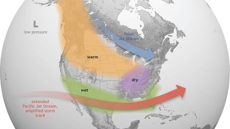
It also reported that April was the third-hottest month globally on record, sitting 1.43 degrees Celsius above the pre-industrial benchmark, which is the average temperature of the Earth between 1850 and 1900, before fossil fuels began warming the planet at scale. Turbulent Friday: Half of India will be on fire, other half to get drenched forecast thunderstorms, gusty winds and heatwave conditions across several parts of India on Friday. The warning underlines a sharp pre-monsoon split, with storms in the hills and south and rising heat in the west.
India is in for a turbulent Friday.
The India Meteorological Department (IMD) has forecast a dramatic mix of thunderstorms, lightning, gusty winds, and relentless heat for several parts of the country on Friday, May 8, as the pre-monsoon season gathers pace.
WHERE WILL THE STORMS STRIKE?
The most intense activity will unfold in the hills. A thundersquall, which is a sudden and violent burst of storm-force wind, is expected over Uttarakhand, with speeds reaching 50 to 60 kilometres per hour and gusts of up to 70 kmph. That is enough force to uproot trees, bring down branches, and damage weakly-built structures.
People in the region are advised to stay indoors, unplug electrical appliances, and keep away from trees.
Assam, Meghalaya, Nagaland, Manipur, Mizoram, and Tripura will see thunderstorm activity with gusty winds over the next two days.
Bihar, Odisha, Jharkhand, and the Andaman and Nicobar Islands are also set for stormy weather. Isolated thunderstorm activity is expected across Maharashtra and Madhya Pradesh as well.
WHICH STATES ARE FACING A HEATWAVE?
While storms sweep through some corners of the country, the Sun is doing its worst elsewhere.
Rajkot in Gujarat recorded a blistering 42.9 degrees Celsius on Thursday, the highest maximum temperature recorded in the country this year.
Scorching heat is set to intensify across Gujarat and Rajasthan, with Rajkot recording the country’s highest maximum temperature of 42.9 degrees Celsius on Thursday. Heat wave conditions are expected to grip West Rajasthan and Gujarat between May 9 and 13, with temperatures set to rise by two to three degrees Celsius across Gujarat in the coming days.
Delhi, meanwhile, gets a mild Friday. Maximum temperatures are expected to range between 35 and 37 degrees Celsius under a mainly clear sky.
WILL SOUTH INDIA GET RAIN?
The real relief lies in the south.
Kerala, Tamil Nadu, Puducherry, and Karaikal will receive isolated to scattered thunderstorms accompanied by heavy rainfall, and IMD says this wet spell will persist for the next seven days. These are the classic pre-monsoon showers that farmers across southern India depend on, popularly known as mango showers.
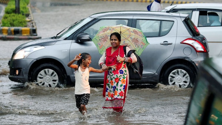
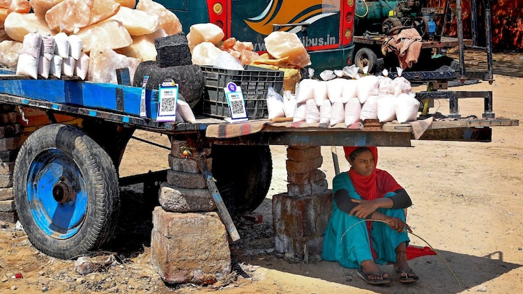
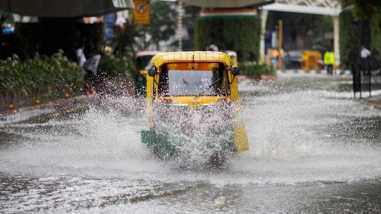
According to IMD, India’s national rainfall last week was 79 per cent above its long-period average, a remarkable statistic for early May.
The southwest monsoon is also expected to make its first landfall over the Andaman and Nicobar Islands by the end of the month.
If you are stepping out on Friday, do not leave home without that umbrella. It is the early signature of an El Nino, and this one could be a Super El Nino.
WHAT EXACTLY IS A SUPER EL NINO?
To understand a Super El Nino, you first need to understand El Nino itself.
Every few years, the central and eastern Pacific Ocean warms above its normal temperature.
This warming disrupts the trade winds, which are the steady easterly winds that blow across the tropics and keep global weather patterns in balance.
When those winds weaken, heat builds up across the Pacific, and weather systems across the entire planet shift in response.
Some regions flood. Others dry out. Temperatures climb.
For an event to be called an El Nino, ocean temperatures only need to rise 0.5 degrees Celsius above the historical average.
A Super El Nino is a far more extreme version, one where the warming exceeds 2 degrees Celsius. Think of the difference between a mild fever and a dangerously high one. The body looks the same from the outside, but the consequences are in a completely different league. Watch: Bright rainbow clouds light up skies in Indonesia. Know the science behind a viral video from Bogor, Indonesia, shows a rare iridescent cloud shimmering with rainbow colours. Learn the science behind this atmospheric phenomenon and how light diffraction creates these stunning visuals.

The sky over Bogor, Indonesia, recently transformed into a canvas of shimmering pastel hues, leaving locals and social media users in awe. This rare sight, often called a fire rainbow by those captivated by its beauty, is actually a complex atmospheric event known as cloud iridescence. While the visuals look like something out of a high-budget fantasy film, the science behind them is rooted in how sunlight interacts with water and ice.
WHAT ARE IRIDESCENT CLOUDS?
Cloud iridescence is a visual treat that occurs when thin clouds sit near the sun. These clouds are usually made of tiny water droplets or ice crystals of a very uniform size. When sunlight hits these uniform particles, it does not just reflect; it undergoes diffraction.

HOW DID THE INDONESIA RAINBOW CLOUD FORM?
The specific spectacle in Indonesia was linked to a phenomenon called a pileus cap. Imagine a massive, bubbling thunderstorm cloud, known as a cumulonimbus, rising rapidly through the atmosphere.
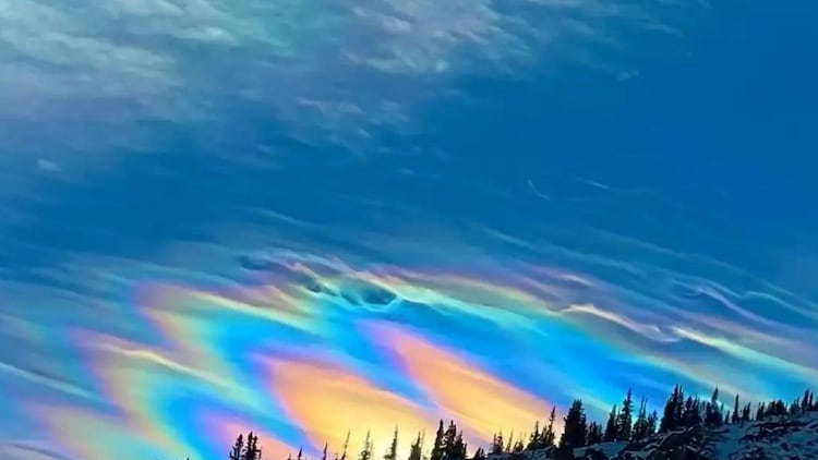
A smooth pileus cap cloud formed over a thunderstorm providing the perfect conditions for iridescence. As it pushes upwards, it forces the air above it to rise and cool quickly. This creates a smooth, cap like cloud that sits on top of the storm like a crown.
This pileus cloud is the perfect stage for iridescence because its droplets are fresh and all roughly the same size. When the sun hits this cap at just the right angle, usually within 10 to 40 degrees of the sun, the light shatters into a spectrum of colours.
ARE IRIDESCENT CLOUDS DANGEROUS TO LOOK AT?
While these clouds are stunning, they can be tricky to spot because they occur so close to the sun. Looking directly at them without protection can be harmful to your eyes.

Sunlight bends around tiny ice crystals to create a shimmering pastel effect in the atmosphere. The best way to catch a glimpse is to wait for a building, a tree, or even a thick cloud to block the main glare of the sun, allowing the delicate, shimmering edges of the iridescent cloud to pop against the blue sky.
Each one triggered droughts, floods, wildfires, and food crises across multiple continents.
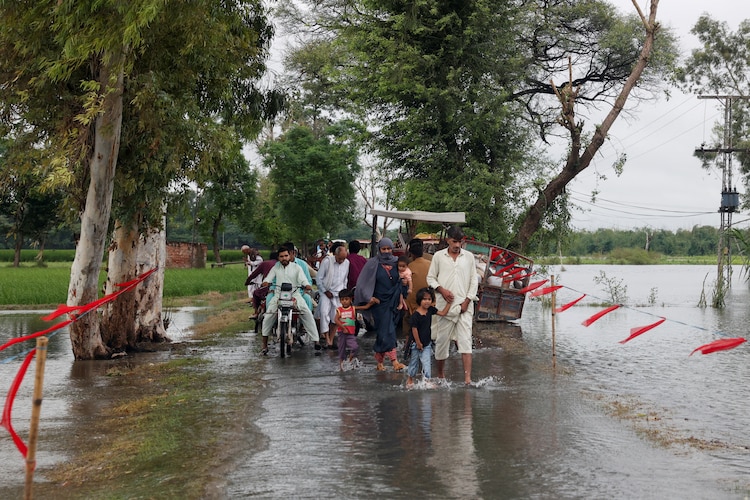
The 2015 to 2016 event alone pushed India into widespread drought conditions, with actual monsoon rainfall recording just 86 per cent of the historical average.
The World Meteorological Organization (WMO), which is the United Nations body that monitors global weather, confirmed last month that El Nino conditions could develop as early as May to July 2026.
Several major forecast models, including those from the ECMWF in Europe and Noaa, which is America’s primary ocean and weather agency, are now aligned on a trajectory that could push this event into Super El Nino territory. Zeke Hausfather, a scientist at Berkeley Earth, an independent climate research organisation, has written that a strong El Nino could significantly raise the chances of 2027 becoming the hottest year ever recorded.
Burgess echoed this, noting that El Nino’s impact on global temperatures typically arrives the year after it peaks. “We’re likely to see 2027 exceed 2024 for the warmest year on record,” she said.
WILL INDIA’S MONSOON BE HIT?
For India, the timing of this event is deeply concerning. The India Meteorological Department (IMD) officially forecast on April 13, 2026 that the southwest monsoon, which delivers over 70 per cent of India’s annual rainfall and is the lifeline of hundreds of millions of farmers, is likely to be below normal this year.
Rainfall is projected at just 92 per cent of the Long Period Average, or LPA. The LPA is the benchmark figure calculated by averaging 50 years of historical rainfall data, from 1971 to 2020, and works out to approximately 87 centimetres.
IMD’s forecast maps show that most of India, barring the extreme north, extreme west, the northeast, and parts of the southern peninsula, faces a genuine rainfall deficit this season.
The chances of a severely deficient monsoon, meaning rainfall below 90 per cent of the LPA, stand at 35 per cent. That is more than double the historical long-term probability of 16 per cent.
IS THERE ANY GOOD NEWS FOR INDIA?
There is one potential buffer: the Indian Ocean Dipole, or IOD.
The IOD measures the temperature difference between the western and eastern halves of the Indian Ocean.
When the western side is warmer, scientists call it a positive IOD, and it tends to push extra moisture towards India, sometimes offsetting El Nino’s drying influence.
This is precisely what happened in 1997, when a powerful positive IOD neutralised a Super El Nino and saved India from drought.
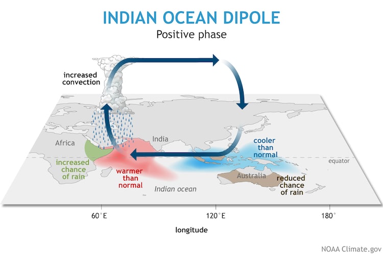
The Indian Ocean Dipole acts as a natural counterweight to El Nino’s drying effect on India. In 1997, a strong positive IOD saved India from drought despite a raging Super El Nino. In 2026, the IOD remains neutral and offers no such protection. However, IMD reports that the IOD is currently in a neutral state, meaning neither side of the Indian Ocean is significantly warmer than the other.
A positive phase is only expected towards the tail end of the monsoon season, arriving too late to meaningfully protect July and August, which are the two months that matter most for Indian agriculture.
As Burgess put it simply: “We just keep seeing extremes. Every month we have more data that climate change is creating these extreme events.”
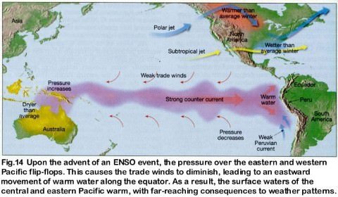
For India, 2026 may be one such extreme. As the global Pacific El Niño officially establishes itself and threatens to weaken the southwest monsoon, meteorologists are closely watching the Indian Ocean. While a powerful Pacific El Niño suppresses Indian rainfall by altering atmospheric circulation, a positive Indian Ocean Dipole works in the opposite direction. It can pump extra moisture into the subcontinent, occasionally saving India from a severe drought. India Meteorological Department has forecast ‘below-normal’ monsoon rainfall at 92% of Long Period Average (LPA).
Current Monsoon Deficit in India
- LPA Benchmark: LPA for India’s southwest monsoon (June–September) is 87 cm, based on the 1971–2020 average.
El Nino
- El Niño is the name given to the occasional development of warm ocean surface waters along the coast of Ecuador and Peru.
- When this warming occurs the usual upwelling of cold, nutrient rich deep ocean water is significantly reduced.
- El Niño normally occurs around Christmas and usually lasts for a few weeks to a few months.
- Sometimes an extremely warm event can develop that lasts for much longer time periods. In the 1990s, strong El Niños developed in 1991 and lasted until 1995, and from fall 1997 to spring 1998.
Normal Conditions
- In a normal year, a surface low pressure develops in the region of northern Australia and Indonesia and a high pressure system over the coast of Peru. As a result, the trade winds over the Pacific Ocean move strongly from east to west.
- The easterly flow of the trade winds carries warm surface waters westward, bringing convective storms (thunderstorms) to Indonesia and coastal Australia. Along the coast of Peru, cold bottom cold nutrient rich water wells up to the surface to replace the warm water that is pulled to the west.
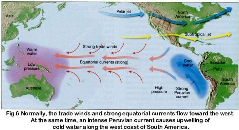
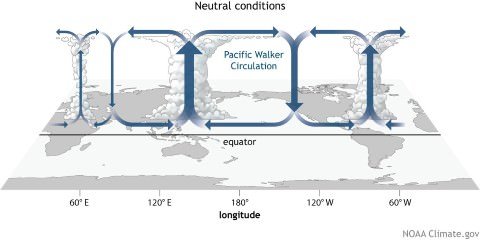
Walker circulation (Occurs during Normal Years)
- The Walker circulation (walker cell) is caused by the pressure gradient force that results from a high pressure system over the eastern Pacific ocean, and a low pressure system over Indonesia.
This cross-section of the Pacific Ocean, along the equator, illustrates the pattern of atmospheric circulation typically found at the equatorial Pacific. Note the position of the thermocline.
- Thermocline == noun a temperature gradient in a lake or other body of water, separating layers at different temperatures.
- The Walker cell is indirectly related to upwelling off the coasts of Peru and Ecuador. This brings nutrient-rich cold water to the surface, increasing fishing stocks.
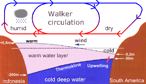
During El Nino year
- In an El Niño year, air pressure drops over large areas of the central Pacific and along the coast of South America.
- The normal low pressure system is replaced by a weak high in the western Pacific (the southern oscillation). This change in pressure pattern causes the trade winds to be reduced == Weak Walker Cell. Sometimes Walker Cell might even get reversed.
- This reduction allows the equatorial counter current (current along doldrums) to accumulate warm ocean water along the coastlines of Peru and Ecuador.
- This accumulation of warm water causes the thermocline to drop in the eastern part of Pacific Ocean which cuts off the upwelling of cold deep ocean water along the coast of Peru.
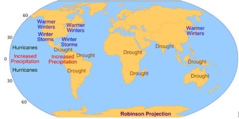
- Climatically, the development of an El Niño brings drought to the western Pacific, rains to the equatorial coast of South America, and convective storms and hurricanes to the central Pacific.
This cross-section of the Pacific Ocean, along the equator, illustrates the pattern of atmospheric circulation that causes the formation of the El Niño.
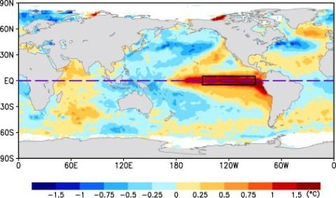
- In the image above, we can see the presence of a strong El Niño event (October, 1997).
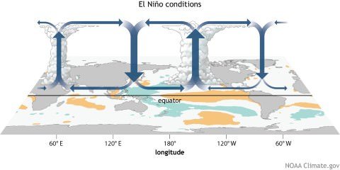
Effects of El Nino
- The warmer waters had a devastating effect on marine life existing off the coast of Peru and Ecuador.
- Fish catches off the coast of South America were lower than in the normal year (Because there is no upwelling).
- Severe droughts occur in Australia, Indonesia, India and southern Africa.
- Heavy rains in California, Ecuador, and the Gulf of Mexico.
Normal Conditions
Eastern Pacific == Coast of Peru and Ecuador == Cold Ocean Water == Good for Fishing.
Western Pacific == Indonesia and Australia == Warm Ocean Water == Plenty of rains.
El Nino Condition
Eastern Pacific == Coast of Peru and Ecuador == Warm Ocean Water == Fishing industry takes a hit.
Western Pacific == Indonesia and Australia == Cold Ocean Water == Drought.
How El Nino impacts monsoon rainfall in India
- El Nino and Indian monsoon are inversely related.
- The most prominent droughts in India – six of them – since 1871 have been El Nino droughts, including the recent ones in 2002 and 2009
- However, not all El Nino years led to a drought in India. For instance, 1997/98 was a strong El Nino year but there was no drought (Because of IOD).
- On the other hand, a moderate El Nino in 2002 resulted in one of the worst droughts.
- El Nino directly impacts India’s agrarian economy as it tends to lower the production of summer crops such as rice, sugarcane, cotton and oilseeds.
- The ultimate impact is seen in the form of high inflation and low gross domestic product growth as agriculture contributes around 14 per cent to the Indian economy.
El Nino Southern Oscillation [ENSO]
- The formation of an El Niño [Circulation of Water] is linked with Pacific Ocean circulation pattern known as the southern oscillation [circulation of atmospheric pressure]
- Southern Oscillation, in oceanography and climatology, is a coherent inter-annual fluctuation of atmospheric pressure over the tropical Indo-Pacific region.
- El Nino and Southern Oscillation coincide most of the times hence their combination is called ENSO – El Nino Southern Oscillation.
Only El Nino == [Warm water in Eastern Pacific + Cold water in Western Pacific].
Only SO == [Low Pressure over Eastern Pacific + High Pressure over Western Pacific]
ENSO = [Warm water in Eastern Pacific + Low Pressure over Eastern Pacific] + [Cold water in Western Pacific + High Pressure over Western Pacific].
Southern Oscillation Index and Indian Monsoons
- SO is a see-saw pattern of meteorological changes observed between the Eastern Pacific and Western Pacific.
- When the pressure was high over equatorial Eastern Pacific, it was low over the equatorial Western Pacific and vice versa.
- The pattern of low and high pressures gives rise to vertical circulation along the equator with its rising limb over low pressure area and descending limb over high pressure area. This is known as Walker Circulation.
- The location of low pressure and hence the rising limb over Western Pacific is considered to be conductive to good monsoon rainfall in India.
- Its shifting eastward from its normal position, such as in El Nino years, reduces monsoon rainfall in India.
- Due to the close association between an El Nino (E.N.) and the Southern Oscillation SO the two are jointly referred to as an ENSO event.
- The periodicity of SO is not fixed and its period varies from two to five years.
- Southern Oscillation Index (SOD) is used to measure the intensity of the Southern Oscillation.
- This is the difference in pressure between Tahiti in French Polynesia (Central Pacific), representing the Central Pacific Ocean and Port Darwin, in northern Australia representing the Eastern Pacific Ocean.
- The positive and negative values of the SOI i.e. Tahiti minus the Port Darwin pressure are pointers towards good or bad rainfall in India.
| Positive SOI | Negative SOI |
| Tahiti pressure greater than that of Port Darwin | Reverse |
| Pressure high over eastern Pacific and low over | Reverse |
| Drought conditions in Eastern Pacific and good rainfall in Western Pacific (Northern Australia and Indonesia) | Reverse |
| Good for Indian Monsoons | Bad for Indian Monsoons |
Indian Ocean Dipole effect (Not every El Nino year is same in India)
- Although ENSO was statistically effective in explaining several past droughts in India, in the recent decades the ENSO-Monsoon relationship seemed to weaken in the Indian subcontinent. For e.g. the 1997, strong ENSO failed to cause drought in India.
- However, it was later discovered that just like ENSO was an event in the Pacific Ocean, a similar seesaw ocean-atmosphere system in the Indian Ocean was also at play. It was discovered in 1999 and named the Indian Ocean Dipole (IOD).
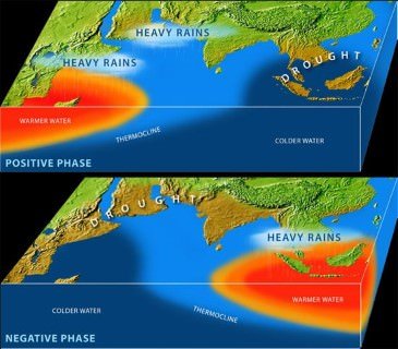
- The Indian Ocean Dipole (IOD) is defined by the difference in sea surface temperature between two areas (or poles, hence a dipole) – a western pole in the Arabian Sea (western Indian Ocean) and an eastern pole in the eastern Indian Ocean south of Indonesia.
- IOD develops in the equatorial region of Indian Ocean from April to May peaking in October.
- With a positive IOD winds over the Indian Ocean blow from east to west (from Bay of Bengal towards Arabian Sea). This results in the Arabian Sea (western Indian Ocean near African Coast) being much warmer and eastern Indian Ocean around Indonesia becoming colder and dry.
- In the negative dipole year (negative IOD), reverse happens making Indonesia much warmer and rainier.
- It was demonstrated that a positive IOD index often negated the effect of ENSO, resulting in increased Monsoon rains in several ENSO years like the 1983, 1994 and 1997.
- Further, it was shown that the two poles of the IOD – the eastern pole (around Indonesia) and the western pole (off the African coast) were independently and cumulatively affecting the quantity of rains for the Monsoon in the Indian subcontinent.
- Similar to ENSO, the atmospheric component of the IOD was later discovered and named as Equatorial Indian Ocean Oscillation [EQUINOO][Oscillation of warm water and atmospheric pressure between Bay of Bengal and Arabian Sea].
Impact on IOD on Cyclonogeneis in Northern Indian Ocean
- Positive IOD (Arabian Sea warmer than Bay of Bengal) results in more cyclones than usual in Arabian Sea.
- Negative IOD results in stronger than usual cyclonogenesis (Formation of Tropical Cyclones) in Bay of Bengal. Cyclonogenesis in Arabian Sea is suppressed.
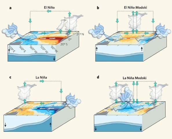
The El Niño Modoki
- El Niño Modoki is a coupled ocean-atmosphere phenomenon in the tropical Pacific.
- It is different from another coupled phenomenon in the tropical Pacific namely, El Niño.
- Conventional El Niño is characterized by strong anomalous warming in the eastern equatorial Pacific.
- Whereas, El Niño Modoki is associated with strong anomalous warming in the central tropical Pacific and cooling in the eastern and western tropical Pacific (see figure below).
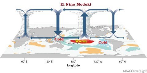
El Niño Modoki Impacts
- The El Niño Modoki phenomenon is characterized by the anomalously warm central equatorial Pacific flanked by anomalously cool regions in both west and east.
- Such zonal gradients result in anomalous two-cell Walker Circulation over the tropical Pacific, with a wet region in the central Pacific.
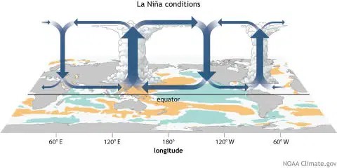
La Nina
- After an El Niño event weather conditions usually return back to normal.
- However, in some years the trade winds can become extremely strong and an abnormal accumulation of cold water can occur in the central and eastern Pacific. This event is called a La Niña.
- A strong La Niña occurred in 1988 and scientists believe that it may have been responsible for the summer drought over central North America. During this period, the Atlantic Ocean has seen very active hurricane seasons in 1998 and 1999.
- One of the hurricanes that developed, named Mitch, was the strongest October hurricane ever to develop in about 100 years of record keeping.