
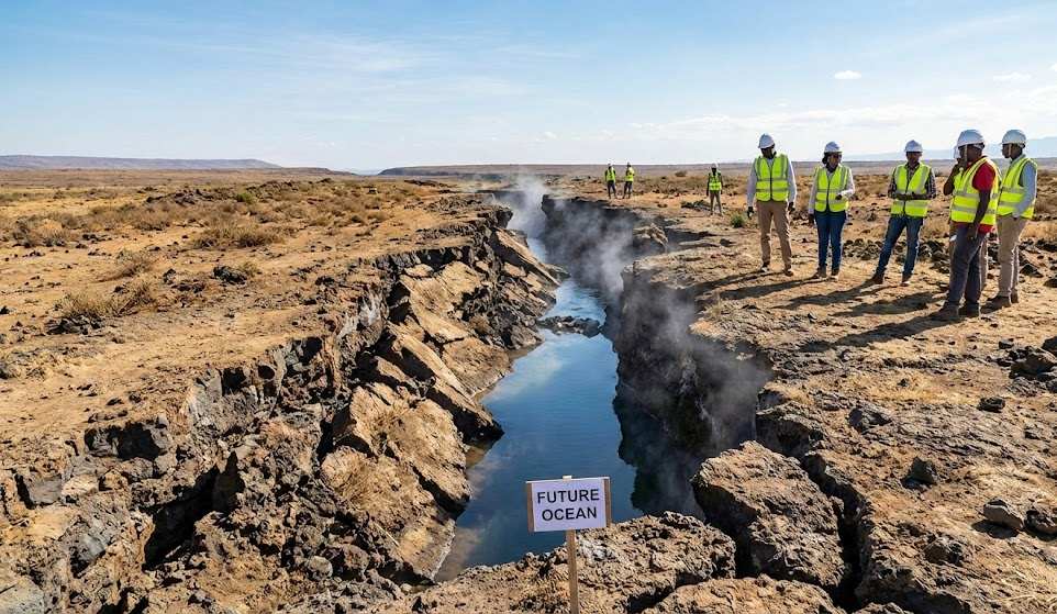
Africa, the second-largest continent in the world, is undergoing a significant and gradual transformation that could shape its future geography for millions of years. The East African Rift, a geological feature running from the Red Sea down to Mozambique, is slowly pulling the continent apart. Over millions of years, this rift is expected to split Africa into two separate landmasses, potentially giving birth to a new ocean. While this may seem like a distant event, the geological processes are already underway. In this article, we explore the science behind Africa’s slow split, the potential impacts on geography, ecosystems, and society, and what the future holds for the continent.
The East African Rift: A Slow Geological Transformation
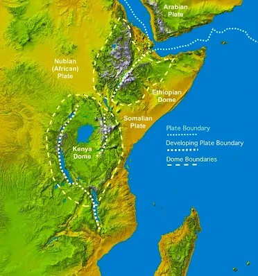
The East African Rift is a vast fault system that stretches across eastern Africa. This system extends from the northern Red Sea, through Ethiopia, Kenya, and Tanzania, and toward Mozambique in the south. It is one of the most active rift zones on Earth, where the Earth’s tectonic plates are gradually pulling apart. The process, known as rifting, is caused by the tension between the plates as they slowly drift apart. The African continent is made up of two primary tectonic plates: the Nubian Plate, which forms the bulk of the continent, and the Somali Plate, which includes the Horn of Africa. The rift system divides these two plates, and over time, the tension between them causes the land to crack, creating deep valleys and geological features, including volcanoes and fault lines. This ongoing geological activity is slowly pulling East Africa away from the rest of the continent.
What’s Causing the Split?
The Earth’s outer shell, the lithosphere, is divided into several large tectonic plates that float on the semi-fluid mantle beneath. These plates move very slowly—often just a few millimeters each year—but over millions of years, their movement has profound effects on the Earth’s surface. In East Africa, the Nubian and Somali plates are slowly pulling apart due to tectonic forces beneath the Earth’s crust.
As the plates drift apart, they create fissures, cracks, and deep valleys. The East African Rift is an example of an active continental rift, where the tectonic plates are being stretched, thinned, and pulled apart. This stretching and cracking of the crust is what eventually leads to the formation of a new ocean—a process that could take tens of millions of years.
How Did the Rift Begin?
The East African Rift didn’t form overnight. Geological evidence suggests that the rifting process began around 25 to 30 million years ago. As the tectonic plates in the region started to stretch, the Earth’s crust began to crack. This long process of rifting was further intensified by volcanic activity, which created the massive volcanoes and deep valleys that characterize the region today, such as the Great Rift Valley.
Over time, volcanic eruptions, earthquakes, and the gradual sinking of land have deepened the rift and caused the land to sink in some areas while rising in others. The East African Rift is not just a single crack; it’s a complex system of fault lines and volcanic activity, which makes the region one of the most geologically active places on Earth. A New Ocean on the Horizon?
As the rift continues to widen, scientists predict that it will eventually lead to the formation of a new ocean. Seawater from the Red Sea and the Gulf of Aden will eventually flood into the rift, forming a new body of water that will split East Africa from the rest of the continent. This process is gradual and will take millions of years to complete. However, it will completely reshape the geography of the continent.
The new ocean would likely begin as a narrow sea and gradually expand over time. While this process is happening slowly, it could eventually create two separate landmasses: one that includes much of the African continent and another that includes the islands of the Horn of Africa and the Arabian Peninsula.
How Long Will It Take?
The rifting process is incredibly slow, and it will take tens of millions of years for the rift to fully separate the continent. Experts predict that the rift will become a narrow sea or a series of smaller seas before eventually connecting to larger bodies of water. Although we may not live to witness this dramatic transformation, scientists are closely monitoring the area to understand the dynamics of plate tectonics and the formation of new oceans.
As the rift deepens and widens, the land along the rift will sink, and eventually, seawater will flow into the fissure. The result could be the birth of a new ocean that divides East Africa from the rest of the continent, creating a completely new coastline and changing the geography of the region.
Potential Impacts on Africa’s Future
The formation of a new ocean in East Africa raises several important questions for the future of the continent. As the geological process unfolds, it will have far-reaching consequences for Africa’s ecosystems, economy, and human society.
New Coastlines and Ecosystems
When the new ocean finally forms, it will create new coastlines along East Africa. As seawater moves into the rift, it will transform the surrounding ecosystems, possibly creating new marine life while disrupting existing terrestrial habitats. The formation of this ocean will alter the landscape of the region and may bring new challenges to agriculture, wildlife conservation, and human settlement.
The creation of new coastlines could also bring new opportunities. East African nations that are currently landlocked, like Ethiopia, could gain access to maritime trade routes, which would boost economic growth and global connectivity.
Changes to Climate and Environment
The creation of a new ocean would significantly alter the climate of East Africa. Oceans have a cooling effect on nearby land, and the formation of a large body of water between East Africa and the rest of the continent could alter weather patterns. The region might experience changes in rainfall, with some areas becoming wetter and others drier. This shift in climate could impact agriculture, biodiversity, and human livelihoods.
As the land continues to sink and move apart, new lakes, rivers, and valleys will likely form. These environmental changes will take place over millions of years, but they will ultimately reshape the entire region.
Impact on Human Populations
The splitting of Africa will have long-term effects on human populations in East Africa. The formation of new coastlines could lead to population displacement, especially in areas prone to flooding. Coastal cities and communities may need to adapt to rising sea levels and changing environmental conditions.
The shift in geography could also lead to the development of new trade routes, opening up new opportunities for economic growth and international exchange. However, it will also require significant adaptation in terms of infrastructure, agriculture, and social structures.
The Role of Scientists in Understanding the Rift
Studying the East African Rift is crucial for understanding how continents split and how new oceans form. Scientists use a combination of geological fieldwork, satellite data, and GPS monitoring to track the movement of tectonic plates and analyze the effects of rifting. These advanced technologies have provided real-time data on the rift’s expansion, helping researchers predict future seismic and volcanic activity in the region.
Conclusion: Africa’s Ongoing Evolution
The slow split of Africa is a fascinating and ongoing geological phenomenon that will continue to unfold over millions of years. While the immediate effects of the rift may not be visible, the long-term impact on Africa’s geography, ecosystems, and economy will be profound. As scientists continue to study the East African Rift, we gain valuable insights into the Earth’s dynamic nature and the ever-changing forces that shape our planet. While we may never see the new ocean form, the process reminds us that the Earth is constantly evolving, and Africa’s future will look radically different in the distant future. It’s fascinating to think about Earth as a living, moving puzzle. What you’re referring to is the East African Rift (EAR), a massive geological event that is literally reshaping the map of the world—though at a pace that makes “snail’s crawl” look like a sprint.
African Rift Valley: Splitting a Continent The Great Rift Valley is one of Earth’s most prominent geological features. It is not a single, continuous valley but rather a complex system of interconnected rifts, faults, and geographic depressions that span approximately 6,000 to 7,000 kilometers (3,700 to 4,300 miles). Scientists believe it may eventually split the African continent into two distinct landmasses—a transformation that could alter the geography of our world in millions of years. Rift Valleys: Formation, Pictures, and Examples Rift valley is a long, narrow depression in the Earth’s crust. They are formed by tectonic plates pulling away from each other, a process called rifting. The resulting valley is typically bordered by steep escarpments and can be the site of volcanic activity and earthquakes.
The Rift Valley is not a single valley, but rather a system of interconnected valleys, troughs, and lakes formed by the divergent movement of tectonic plates.
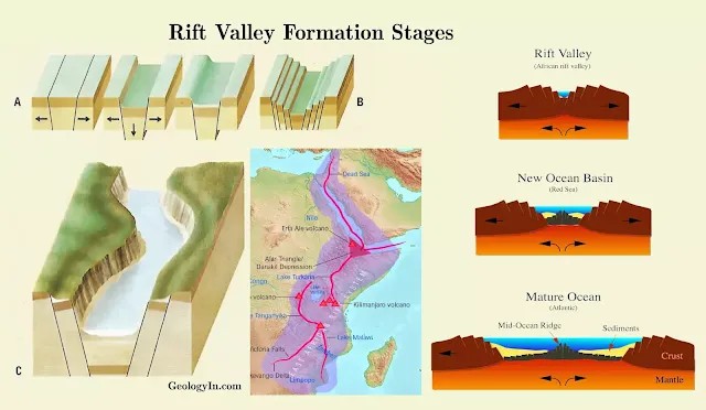
Divergent Boundary: Definition, Features, Examples Extensional Tectonic: Formation of Rift Valleys and Ocean Basins Extensional tectonics is a geological process associated with the stretching and thinning of the Earth’s crust or lithosphere.
Extensional tectonics occurs where tectonic plates are pulling apart, which can lead to the formation of structures like normal faults, rift valleys, and in larger scales, new oceanic crust at mid-ocean ridges. This process is fundamental at divergent plate boundaries.
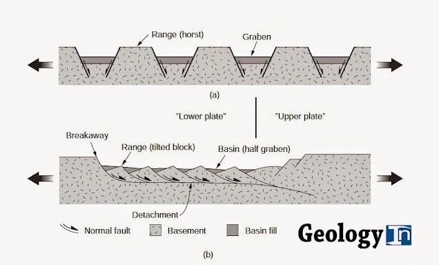
Geometry of normal fault arrays, in cross section. (a) Parallel rotational faults. Before faulting (top), the faults are parallel and not curved. After faulting (bottom), fault blocks are tilted. In reality, crushing and small-scale faulting at the base of the blocks fill the gaps.
Key Concepts in Extensional Tectonics
Rifting: This is perhaps the most direct manifestation of extensional tectonics, where the crust is stretched, leading to the formation of rift valleys. African Rift Valley: Splitting a Continent. The Great Rift Valley is one of Earth’s most prominent geological features. It is not a single, continuous valley but rather a complex system of interconnected rifts, faults, and geographic depressions that span approximately 6,000 to 7,000 kilometers (3,700 to 4,300 miles). Scientists believe it may eventually split the African continent into two distinct landmasses—a transformation that could alter the geography of our world in millions of years. How are rift valleys formed
Rift valleys are formed by the separation of tectonic plates. As the plates pull apart, the Earth’s crust stretches and thins, causing the land above to sink and form a long valley. Let’s examine the sequential stages involved in rift valley formation. Divergent Plate Boundaries and Extensional Tectonics
At divergent boundaries, tectonic plates slowly move away from each other. This movement creates extensional tectonics, a zone of stretching forces pulling the lithosphere, This stretching force thins and weakens the lithosphere, the rigid upper layer of the Earth composed of the crust and uppermost mantle.
Lithospheric Thinning and Normal Faulting
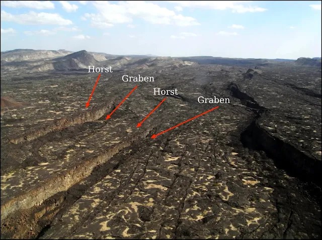
The extensional forces cause the lithosphere to thin and weaken. As it thins, the lithosphere experiences stress, eventually fracturing along normal faults. These are cracks in the Earth’s crust where the rock on either side is displaced vertically. The central block of crust between the normal faults sinks downwards due to the extensional forces. This creates a depressed area called a graben, relative to the uplifted sides (footwalls) due to the extensional forces. This subsidence creates the initial depression of the rift valley.
Erosion and Sedimentation
Over geological timescales, wind, rain, and other erosional processes widen and deepen the rift valley. Additionally, sediments eroded from the uplifted flanks (shoulders) of the valley can accumulate on the valley floor. Continued Divergence and Evolution
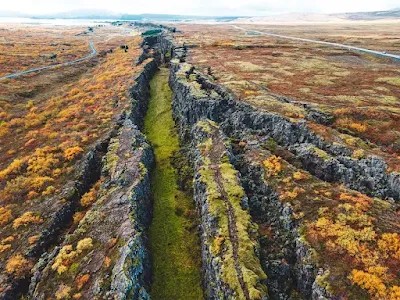
As the plates continue to diverge, the rift valley may widen and deepen. The graben floor may subside further, and volcanic activity might continue along the rift margins. In some instances, the rifting process may eventually lead to the formation of a new ocean basin if the divergence continues for millions of years (e.g., the Red Sea).
Types of Rift Valleys
Strictly speaking, there aren’t different types of rift valleys based on their formation process. Since they all originate from the same phenomenon – divergent plate boundaries – they share a common geological mechanism. However, geologists sometimes categorize rift valleys based on their stage of development or their location: Active Vs. Inactive Rift Valleys
Active Rift Valleys
Active rift valleys are those where the stretching and thinning of the crust is still happening. This is usually caused by the movement of tectonic plates at a divergent boundary. These areas are geologically young and are often characterized by:
Volcanic activity
Earthquakes
How was African Rift valley formed
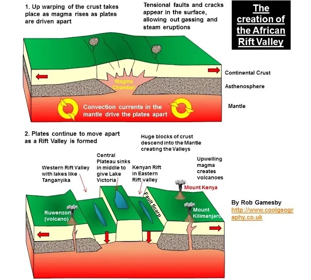
The African Rift Valley was formed through a process known as continental rifting, where the African Plate is gradually splitting into two smaller plates: the Nubian Plate to the west and the Somali Plate to the east. This rifting began approximately 20–25 million years ago, driven by several geological forces:
Plate Divergence
The divergence of the Nubian and Somali plates leads to the thinning of the Earth’s crust, with crustal thickness in some areas reduced to around 20 km—significantly thinner than the typical 30–50 km of continental crust. This thinning is primarily due to the stretching and extension of the crust as the plates move apart.
Tectonic Forces
The primary force behind this rifting is the upwelling of mantle plumes beneath East Africa. These plumes heat, thin, and weaken the lithosphere (the crust and the uppermost mantle), facilitating the rifting process.
Rifting Process
As the plates pull apart, several notable features emerge:
Faulting and Landscape Formation: The crust stretches and develops faults, where blocks of the Earth’s surface drop down relative to others, creating the characteristic landscape of the rift valley.
Volcanic Activity: The decompression melting of the mantle often accompanies rifting, allowing magma to rise and, in some cases, erupt at the surface.
Stages of Rifting
Rifting occurs in distinct stages along the valley. In areas like the Afar Triangle, the process is highly advanced, with an extremely thin crust and significant volcanic activity. This region offers a glimpse into what the area might look like millions of years from now if the plates fully separate, potentially forming a new ocean basin. Other areas of the rift are less intense, with fewer active volcanoes and broader, more subtle valleys.
Structural Features of the Rift Valley
Faulting and Escarpments
The tectonic divergence within the African Rift Valley creates normal faults, where one side of a fault line drops relative to the other. This faulting forms the valley’s iconic steep cliffs and escarpments, with towering walls surrounding the rift on either side. The faulting also generates frequent earthquakes throughout the valley.
Graben Structure
The rift valley consists of multiple elongated troughs, or grabens. These deep depressions, flanked by steep, faulted walls, form the valley’s core structure and extend for hundreds of kilometers, creating a rugged topography.
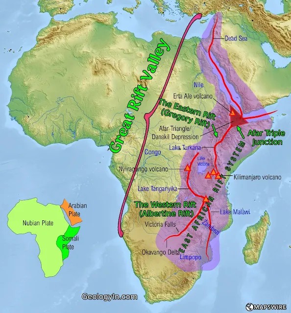
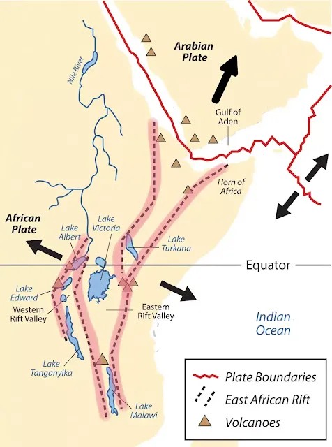
| The Great Rift Valley Map, including the Eastern and Western Rifts, which form part of the East African Rift System. |
The Eastern Rift (Gregory Rift)
The Eastern Rift stretches southward from the Afar Triangle in northern Ethiopia, through Kenya and Tanzania, and into northern Mozambique. This rift is highly tectonically active, with volcanic peaks like Mount Kilimanjaro and Mount Kenya highlighting its volcanic history. Its faulted valleys are often shallow and host numerous alkaline and saline lakes, such as Lake Turkana in Kenya, the world’s largest alkaline lake, and Lake Natron in Tanzania, known for its unique pink flamingo populations.
The Western Rift (Albertine Rift)
The Western Rift follows the rift’s western boundary and spans Uganda, Rwanda, Burundi, the Democratic Republic of the Congo, and parts of Tanzania. It is named after Lake Albert, a prominent lake within the rift. This rift branch has the world’s deepest and oldest freshwater lakes, including Lake Tanganyika and Lake Kivu, which have formed due to the subsiding rift floor. The Western Rift is rich in biodiversity and ecologically significant, home to rainforests and mountain gorillas. The active volcanic zones in the DRC, with volcanoes like Mount Nyiragongo and Mount Nyamuragira, make this rift branch prone to eruptions and seismic activity.
The Afar Triple Junction
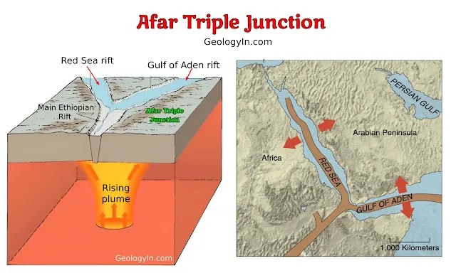
A Meeting Point of Three Rifts. At the Afar Triangle in northeastern Ethiopia, three rift systems converge in a unique geological feature known as the Afar Triple Junction. Here, the East African Rift, the Red Sea Rift, and the Gulf of Aden Rift meet, making it one of the most geologically active places on Earth. This convergence results in intense tectonic and volcanic activity, creating a distinct region where rifting processes can be observed in their early stages.
Red Sea Rift: This rift extends northward from the Afar Triangle into the Red Sea, marking the boundary between the Arabian Plate and the Nubian (African) Plate. As the Red Sea Rift continues to spread, it gradually widens, moving the Arabian Peninsula away from Africa.
Gulf of Aden Rift: Stretching eastward from the Afar Triangle, this rift separates the Arabian Plate from the Somali Plate, forming a spreading center in the Gulf of Aden. This ongoing rifting contributes to the tectonic movement within the region.
Main Ethiopian Rift (East African Rift): The East African Rift extends southward from the Afar region, crossing Ethiopia, Kenya, Tanzania, and other countries, marking the boundary between the Nubian and Somali Plates.
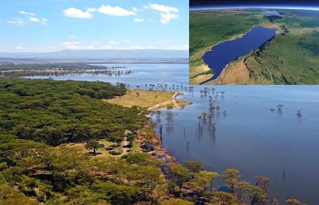
Geographical Features of the African Rift Valley
Volcanism and Magmatism: As the crust thins, magma rises, forming active volcanoes such as Mount Nyiragongo and Mount Fentale. This continuous volcanic activity makes the rift one of the most geologically dynamic regions in the world.
Valleys and Basins: The Rift Valley hosts numerous shallow basins and deep valleys, which contain essential freshwater and alkaline lakes like Lake Victoria and Lake Tanganyika. These bodies of water are vital for local ecosystems, providing habitats for a wide variety of flora and fauna.
Linear Lakes: The rifting process has created a chain of long, narrow lakes along the valley floor. Major examples include Lake Tanganyika, Lake Malawi, Lake Turkana, Lake Albert, and Lake Victoria (though its formation is complex and debated). These lakes are often deep and host significant biodiversity.
Mountains and Highlands: The uplifted flanks of the rift have created prominent mountains and highlands, adding dramatic contrast to the landscape of the valley floor. Notable ranges include the Ethiopian Highlands and the Rwenzori Mountains, with elevations exceeding 16,000 feet (4,876 meters).
Diverse Landscapes: The Rift Valley’s landscape is varied, encompassing grasslands, savannas, forests, and deserts, which reflect its changing altitudes, rainfall patterns, and geological history.
Hot Springs and Geysers: Due to extensive geothermal activity, the Rift Valley contains numerous hot springs and geysers, which present unique geothermal energy resources.
Desert Regions: Parts of the rift extend into desert regions, such as the Danakil Depression in Ethiopia, one of the hottest places on Earth. Future of African Rift: Africa splitting Is Africa Splitting Into Two Continents Africa is undergoing a process that may one day lead to it splitting into two continents, but it’s a very slow process that will take millions of years to unfold, if at all.
The East African Rift
The split in the African continent is a geological process that is currently underway.
Normal Faults: These faults occur when the crust is pulled apart, leading to one block slipping down relative to the other. This can create structures like half-grabens, where one side of the fault drops down, forming a basin.
Graben and Horst Structures: A graben is a down-dropped block between two normal faults dipping towards each other, while a horst is the elevated block between two normal faults dipping away from each other.
Metamorphic Core Complexes: In regions of significant extension, lower crustal rocks can be brought to the surface due to the isostatic rebound and the extensional unroofing. These rocks often show signs of ductile deformation due to the high temperatures and pressures at depth.
Basin Formation: Extensional regimes often lead to the formation of sedimentary basins where the stretched and thinned crust subsides, creating space for sediment accumulation.
Mid-Ocean Ridges: While primarily associated with sea-floor spreading, these are zones of extension where new crust is formed as plates move apart. The Mid-Atlantic Ridge is a classic example.
Back-arc Basins: These are formed by extension behind subduction zones, like in the case of the Sea of Japan, due to the rollback of the subducting slab.
Glossary of Extensional Tectonic
Accommodation zones Normal fault systems are not continuous along the length of a rift. Rather, rifts are divided intosegments, whose axes may be offset from one another. Further, the faults of one segment may dip in the opposite direction to the faults of another segment. An accommodation zone is the region of complex structure that links the ends of two rift segments. Accommodation zones typically include strike-slip faults.
Active margin A continental margin that coincides with either a strike-slip or convergent plate boundary, andthus is seismically active.
Aulacogen An unsuccessful rift that cuts across a continental margin at a high angle to the margin. Typically, aulacogens transect the grain of an orogen that borders the margin. Aulacogens may represent failed arms of three-armed rifts, or they may simply be older rifts (formed long before the development of the continental margin, during an earlier episode of rifting at a different orientation) that were cut off when the margin formed.
Axis (of rift or MOR)The center line along the length of a rift or a mid-ocean ridge (MOR). The trend of the axis is the overall trend of the rift.
Breakaway fault The normal fault that forms the edge of the rift. (A breakaway fault forms the boundary between stretched and unstretched crust).
Graben A narrow, symmetric trough or basin, bounded on both sides by normal faults that dip toward the center of the trough.
Half graben An asymmetric basin formed on the back of a tilted fault block; one border of the basin is a normal fault.
Horst An elongate, symmetric crustal block bordered on both sides by normal faults; both faults dip away from the center of the horst.
What is the East Africa Rift System
The oldest and best defined rift occurs in the Afar region of Ethiopia and this rift is usually referred to as the Ethiopian Rift. Further to the South a series of rifts occur which include a Western branch, the “Lake Albert Rift” or “Albertine Rift” which contains the East African Great Lakes, and an Eastern branch that roughly bisects Kenya north-to-south on a line slightly west of Nairobi.
These two branches together have been termed the East African Rift (EAR), while parts of the Eastern branch have been variously termed the Kenya Rift or the Gregory Rift (after the geologist who first mapped it in the early 1900’s). The two EAR branches are often grouped with the Ethiopian Rift to form the East Africa Rift System (EARS). The complete rift system therefore extends 1000’s of kilometers in Africa alone and several 1000 more if we include the Red Sea and Gulf of Aden as extensions. In addition there are several well-defined but definitely smaller structures, called grabens, that have rift-like character and are clearly associated geologically with the major rifts. Some of these have been given names reflecting this such as the Nyanza Rift in Western Kenya near Lake Victoria. Thus, what people might assume to be a single rift somewhere in East Africa is really a series of distinct rift basins which are all related and produce the distinctive geology and topography of East Africa.
How did these Rifts form
The exact mechanism of rift formation is an on-going debate among geologists and geophysicists. One popular model for the EARS assumes that elevated heat flow from the mantle (strictly the asthenosphere) is causing a pair of thermal “bulges” in central Kenya and the Afar region of north-central Ethiopia. These bulges can be easily seen as elevated highlands on any topographic map of the area. Most current geological thinking holds that bulges are initiated by mantle plumes under the continent heating the overlying crust and causing it to expand and fracture. Ideally the dominant fractures created occur in a pattern consisting of three fractures or fracture zones radiating from a point with an angular separation of 120 degrees. The point from which the three branches radiate is called a “triple junction” and is well illustrated in the Afar region of Ethiopia, where two branches are occupied by the Red Sea and Gulf of Aden, and the third rift branch runs to the south through Ethiopia.

The stretching process associated with rift formation is often preceded by huge volcanic eruptions which flow over large areas and are usually preserved/exposed on the flanks of the rift. These eruptions are considered by some geologists to be “flood basalts” – the lava is erupted along fractures (rather than at individual volcanoes) and runs over the land in sheets like water during a flood.
Such eruptions can cover massive areas of land and develop enormous thicknesses (the Deccan Traps of India and the Siberian Traps are examples). If the stretching of the crust continues, it forms a “stretched zone” of thinned crust consisting of a mix of basaltic and continental rocks which eventually drops below sea level, as has happened in the Red Sea and Gulf of Aden. Further stretching leads to the formation of oceanic crust and the birth of a new ocean basin. Here is a breakdown of what is actually happening deep beneath the surface and what the future might look like.
The Three-Way Split
Geologists have identified a specific region in Ethiopia called the Afar Triple Junction. This is where three tectonic plates are slowly pulling away from each other: Triple Junction: The Red Sea/East Africa
The Afar region in Northern Ethiopia is the centre of a “Y” shaped rift system, where the continental lithosphere is being stretched and is splitting.
The Arabian Plate is rifting away from the African plate along an active divergent ridge system, to form the Red Sea and Gulf of Aden. The rifting then extends southwards where the African Plate is itself becoming stretched along the line of the East African Rift Valley and is splitting to form two new plates; the Nubian and Somalian Plates.
In time, as Nubian and Somalian plates move further away from each other, the area between them will grow thinner and drop below sea level. New ocean lithosphere may form along the centre of the rift, producing a new narrow ocean basin with its own mid ocean ridge.
Divergent (Constructive) Margin A plate margin where two oceanic plates are moving away from each other. Divergent margins are responsible for the formation of ocean basins, which start out as rift valleys e.g. the African Rift. As the plates move apart, pressure on the underlying mantle is reduced and it partially melts to form basalt magma. New oceanic crust is formed at the ridge then moves away in both directions, cools and subsides. These margins are characterised by shallow focus earthquakes and basaltic volcanism. An example is the Mid Atlantic Ridge.
Dolerite A medium grained intrusive igneous rock, similar in composition to basalt, but with a slower rate of cooling. It is typically is associated with intrusive igneous bodies such as dykes and sills.
Flood basalts Flood basalts form as a result of large-scale volcanic eruptions of fluid basalt in the ocean or on the continent. They form extensive plateaus in many continents composed of multiple layers of basalt lava erupted over a relatively short time (1 million years or even less) to form a “trap” (step-like) landscape. They are associated with a rising mantle plume and continental rifting which leads to decompression melting. Examples include the Deccan Traps of India, Siberian Traps of Russia and flood basalts of Iceland. They are often suggested as the cause of mass extinction events in the fossil record.
Focus (earthquake) The point of fracture of rocks at depth within the Earth, giving rise to earthquakes. These are classified as shallow (<70 km), intermediate (70 – 300 km) and deep (>300 km).
Folding The process where rocks are deformed by compressional forces and associated with a shortening of the crust. The rocks show plastic deformation and flow to form anticlines (arch-shaped) and synclines (trough shaped, like kitchen sinks). Associated with convergent (destructive) plate margins.
Gabbro A coarse grained intrusive igneous rock, similar in composition to basalt, but which cool very slowly to produce large crystals. It is typically is associated with large scale intrusive igneous bodies (plutons and batholiths).
Gondwana Translated as ‘the forest of the Gonds’ (an Indian tribe) this is the name given to the large land mass of the southern hemisphere that consisted of South America, Africa, Arabia, Madagascar, India, Sri Lanka, Australia, New Zealand and Antarctica all joined as a single continent.
Granite A coarse grained igneous rock comprising the minerals quartz, feldspar, and mica. It corresponds to the average composition of the continental crust. It is formed at convergent (destructive) plate margins, typically in fold mountain (orogenic) belts.
Heat Flow A measure of the heat being conducted through the surface rocks of the Earth. Measurements are taken down boreholes and the highest values correspond to mid-ocean ridges (divergent plate margins), whilst the lowest values occur at ocean trenches (convergent plate margins).
Hess Harry Hess proposed the idea of Sea Floor Spreading, following echo sounding work to reveal the topography of the ocean basins.
Hot Spot An area of abnormally intense active volcanism thought to be underlain by a mantle plume. Many hot spots, for example Hawaii are located in the middle of a lithospheric plate whilst others such as Iceland are located on divergent (constructive) plate margins.
Iapetus Ocean The Palaeozoic ocean that existed in the southern hemisphere between the continents of Laurentia, Baltica and the micro-continent of Avalonia. Closure of this ocean resulted in the Caledonian Orogeny.
Intrusion Igneous rocks that crystallise beneath the Earth’s surface. Smaller scale intrusions may be called dykes and sills; the very largest are plutons and batholiths.
Laser Measurements A method that uses lasers to measure the distance between two or more points. Successive measurements are sufficiently accurate to show how fast plates are moving
Laurasia The name given to the large land mass of the northern hemisphere that consisted of North America, Greenland, Europe and Asia all joined as a single continent.
Laurentia An ancient continent, comprising what is now Scotland, Greenland and North America, on the western margin of the Iapetus Ocean during the Caledonian Orogeny.
Lithosphere The outer cool, rigid and brittle layer of the Earth. It comprises the crust (oceanic or continental) and part of the upper mantle. The base of the lithosphere is marked by a temperature of 1300o C. It has an average of thickness of 100 km but varies from just 1 to 2 km thick at mid-ocean ridges up to 300 km thick beneath mountain ranges. It is dived up into a number of lithospheric plates.
Lithospheric Plate A segment of the lithosphere which has earthquake activity along its margins and in certain situations, eg when associated with subduction zones. Lithospheric plates can consist of just oceanic areas (Nazca Plate) or a combination of oceanic and continental areas (Eurasian Plate). Seven major, eight minor and numerous micro plates have been identified.
Magnetic stripes Linear magnetic stripes, resembling a bar code, run parallel to mid ocean ridges. The stripes reflect repeated magnetic reversal of the Earth’s magnetic field. The magnetic anomalies are also symmetrical either side of the mid ocean ridges. The discovery of magnetic anomalies was crucial evidence for sea floor spreading.
Mantle The zone lying between the Earth’s crust and core. It includes the lower part of the lithosphere and all of the asthenosphere.
Mantle Decompression The process by which basaltic magma is generated at divergent (constructive) plate margins. As the plates move apart, pressure on the underlying mantle is reduced and it partially melts. Also known as decompression melting.
Mantle Plume Hot buoyant rock rising through the mantle from the core-mantle boundary. Thought by some geologists to rise beneath hot spots causing doming up of the crust. Cylindrical in shape, seem to be fixed in position and have a radius of around 150 km.
Matthews Drummond Matthews was the PhD supervisor of Fred Vine at Cambridge University. Together, they were the first to interpret correctly the pattern of normal and reversed magnetic anomalies in ocean floor basalts (eg in the Pacific Ocean floor next to California) as the result of sea floor (ocean-floor) spreading.
McKenzie Dan McKenzie is a Cambridge geophysicist who is known for his work on the structure and thermal properties of the mantle in relation to plate tectonics, and magma generation at mid ocean ridges and hot spots.
Metamorphism A ‘change in form’ as a result of the effects of mainly heat and/or pressure to produce a rock with a different texture and/or mineralogy.
Metamorphism, regional Large scale metamorphism (see above) involving heat and pressure. For example, at convergent (destructive) plate margins, and around large intrusions.
Mid Ocean Ridge The junction between two oceanic plates along a divergent (constructive) plate margin. The ridge comprises a submarine mountain chain of basaltic volcanoes and is up to 1.5 km higher than the adjacent abyssal plain. The central part of the ridge has a rift valley running through it and the ridge is offset sideways by transform faults eg the Mid Atlantic Ridge.
Mohorovičić discontinuity (Moho) The boundary between the crust and the mantle. The Moho exists at an average depth of 7 kms beneath the ocean basin and at an average depth of about 35 kms beneath the continents. It was discovered in 1909.
Mountain Building The process by which fold mountain belts are formed. These occur at convergent (destructive) plate margins. Another term for a fold mountain building period is an orogeny and the subsequent product is an Orogenic Belt. Evidence of past mountain building can be seen in the UK with the Caledonian and Variscan fold mountain belts.
Obduction The process whereby ocean crust (and even upper mantle) are scraped off the descending ocean plate at a convergent plate boundary and thrust onto the adjoining plate. Often associated with an accretionary wedge (prism).
Oceanic Crust The crust that forms the ocean basins. It is basaltic in composition, and comprises an upper layer of pillow lavas, a middle zone of vertical dolerite dykes and a lower layer of gabbro. The average thickness is 7 km and it is formed at mid-ocean ridges and subducted at ocean trenches. The oldest oceanic crust is less than 200 million years old.
Ocean Trench An elongate depression of the ocean floor which runs parallel to a volcanic island arc or mountain belt. Oceanic trenches are the deepest part of the oceans and can be up to 11 km. They are locations where oceanic lithosphere is being subducted back into the asthenosphere. An example is the Peru-Chile Trench which runs parallel to the west coast of South America.
Ophiolite A fragment of oceanic crust and mantle thrust onto a continental margin during ocean closure and at a convergent (destructive) plate margin. Examples in the UK include the Lizard Ophiolite in Cornwall (Variscan Orogeny) and the Ballantrae Ophiolite in Scotland (Caledonian Orogeny).
Orogenic belt A fold mountain belt such as the Andes or Himalayas.
Pangea The name given by Wegener to the supercontinent that he proposed to explain the ice distribution at 300 Ma. It came into being during the Permian and existed for around 40 million years. It was a single land mass comprising most of the world’s land areas joined as a single unit. It subsequently broke up into Laurasia and Gondwana.
Passive Margin An ocean-continent boundary that is not an active plate margin, i.e. there are no earthquakes at the margin. The east and west sides of the Atlantic are good examples at present. In the future, as the Atlantic continues to widen due to sea floor spreading in the centre, the ocean-continent boundaries will eventually become subduction zones with new convergent (destructive) margins being formed.
Palaeomagnetism The study of the fossil magnetism locked in rocks which record the inclination and direction of the Earth’s magnetic field at the time of their formation. Such data is used to determine the past arrangement of the continents over time and support the theories of continental drift and sea-floor spreading.
Peridotite A coarse grained, dark coloured igneous rock consisting mainly of olivine and pyroxene, which is believed to be the major constituent of the mantle.
Partial Melting Incomplete melting of rock to produce magma of a different composition from the original rock. Partial melting of the mantle produces basaltic magma. When partial melting occurs, the minerals with the lowest melting points will melt first, these tend to be the most silica rich minerals in the rock.
Pluton A medium sized igneous intrusion of up to 100 km² with a generally oval or circular shape in plan and steep or near vertical sides. The granite intrusions in South West England such as Bodmin Moor, Carnmanellis and Dartmoor are good examples. Most are associated with convergent (destructive) plate margins.
Polarity The Earth’s magnetic field is known to reverse periodically. When it reverses, what was the north magnetic pole becomes the south magnetic pole, and vice versa. The current period of normal polarity has lasted for 780,000 years. A polarity reversal gives rise to a distinctive magnetic pattern in ocean floor basalts, with the reversely magnetized ocean-floor usually portrayed as white/pale stripes in illustrations, and normal polarity in black. Reversals take place in less than 10,000 years. The length of a polarity interval, either normal polarity or reverse polarity, is highly variable, but is roughly 1 million years.
Radiometric Dating A technique for determining mineral ages from measuring the amount of a radioactive isotope that has remained in a mineral (such as feldspar) since it was first created. As the mineral decays, its decay products accumulate and they can also be measured. These measurements, together with knowledge of the rate of decay, enable its age to be estimated. The most widely used methods of dating are Argon-Argon and Uranium-Lead. Age-dating of basalts of the ocean floor revealed they increased in age away from the mid-ocean ridges, in both directions.
Rheic Ocean The ocean that opened between the continents of Gondwana and a collection of micro-plates including “Avalonia” during the Variscan Orogeny.
Rhyolite A fine grained igneous rock with the same mineral composition as granite. It is commonly associated with volcanoes at convergent (destructive) oceanic-continental plate margins. It is rich in silica, viscous, felsic and is characterised by infrequent but violent eruptions.
Ridge Push Mid-ocean ridges are sites where oceanic lithosphere is created. They are hotter and therefore stand higher than older, cooler lithosphere. As a result, the base of the lithosphere slopes away from the ridges. Under the influence of gravity, the lithosphere tries to move down this slope, creating a “ridge-push” force on the plate it is part of. The force is much smaller – perhaps only a tenth – of the force due to “slab pull”.
Rift Valley A central block down thrown between two normal faults that face one another. Continental rift valleys represent areas where continents are being stretched (extended), as in the case of the East African Rift Valley. They may eventually extend to the point where new ocean-floor is created, as in the Red Sea. Slowly spreading mid-ocean ridges, such as the Mid-Atlantic Ridge, may also have rift valleys running down their centres, but fast spreading ridges such as the East Pacific Rise, do not.

Alright, b77bet is legit. Put down a few bets last night and won some serious dough. Give it a spin: b77bet