The Indian monsoon, crucial for the country’s agriculture, has experienced a sluggish start this year, leading to a significant rainfall deficit. This situation raises concerns for the farm economy, as unpredictable monsoons can cause economic distress for smallholder farmers.
The Indian monsoon system is characterized by winds that reverse direction seasonally, bringing substantial rainfall from June to July. However, factors like El Niño can disrupt this pattern, leading to erratic monsoons and decreased summer rainfall, which negatively impacts crops and the economy.
While agriculture’s share of India’s GDP has decreased, it remains a vital sector, employing about 40 percent of the population and ensuring food security. The country is a leading producer of various agricultural products, including milk, rice, and wheat. Despite technological advancements and government support, challenges such as climate change, unpredictable monsoons, and water availability continue to affect agricultural productivity. A monsoon is a significant wind system characterized by a seasonal reversal of direction, typically blowing from the northeast for about six months and then from the southwest for the remaining six months. While prominent monsoons are found in South Asia, Africa, Australia, and the Pacific coast of Central America, regions like the Gulf Coast of the United States and central Europe experience monsoonal tendencies but not true monsoons.
The primary driver of monsoons is the differential warming between land and sea. Land heats up and cools down more rapidly than oceans. Consequently, monsoon winds generally blow from cooler, high-pressure areas to warmer, low-pressure areas. This means winds typically move from sea to land in the summer and from land to sea in the winter.
Summer monsoons often feature a dominant western component and tend to ascend, producing substantial rainfall due to the condensation of water vapor in rising air. Conversely, winter monsoons have a prevailing easterly component and tend to diverge and subside, leading to dry conditions and drought. In South Asia, the monsoon is critical, delivering the majority of rainfall between May and September, which is vital for agriculture and water supply. The global monsoon engine plays a critical role in agricultural productivity, water security, and ecosystem health for billions of people across the planet.
What Are Monsoons and Why Do They Happen?
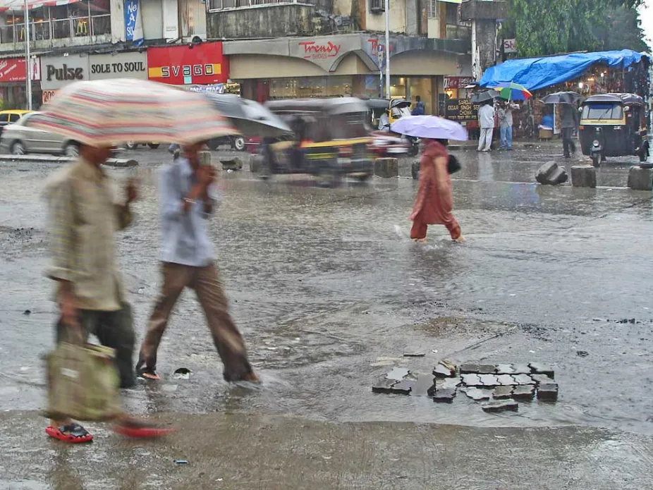
On the evening of June 11, 2015, it began to rain in Mumbai, India, and it did not stop until the next day. Trains were delayed. A wall collapsed with the added weight of water. Notices were posted about the risk of landslides in hilly areas of the city. Two people died as a result of the rainfall. Yet there was a feeling of relief in the city. As a news article in the New Indian Express put it, “Mumbai smiled as heavy showers lashed the city.”
The city was smiling, so to speak, because this storm ended a long heat wave. Before the rain began, it was so hot during May that asphalt roads were melting. In many places in India, humid conditions made the heat feel much hotter. In one location, the heat index, which takes both heat and humidity into account to describe how hot it feels, was over 140°F (60°C). After the rain started, temperatures dropped as clouds shaded Mumbai from the sweltering sun. It was still warm — with high temperatures above 80°F (27°C) — but was much cooler than during the heat wave. The start of rains in early June marked the end of the dry winter and the onset of the wet summer monsoon.
Weather and climate are very different in the tropics and mid-latitudes, and it is not just a matter of the tropics being warmer. In Europe, North America, and other mid-latitude regions, temperatures undergo large changes over the seasonal cycle, and weather events in these regions last a few days as high- and low-pressure systems drift slowly eastward, rearranging the locations of warmer and colder air masses as they go. This might make it cool and rainy one day and warm and sunny the next. In contrast, tropical temperatures don’t change much throughout the year. The seasonal cycle over tropical continents is marked by an oscillation between dry and wet periods brought about by monsoons. Weather events in the tropics, such as typhoons, thunderstorms, and other rainstorms, are actually embedded within the much larger monsoons. Billions of people live in the monsoon climates of South Asia, Africa, and the tropical Americas, and every spring they wait for the monsoon rains that will end the winter dryness even though they might also cause disastrous floods. There is often too little water or too much.
Where Monsoons Are Found
If you are looking for monsoons, you’ll need to head to the tropics. That’s where rain is produced as warm and humid air rises in the Intertropical Convergence Zone (ITCZ), which swings north and south in a seasonal cycle, causing patterns of distinctly wet and dry seasons (explore the Why Monsoons Happen section below to learn more about how this works).
However, monsoons are not the same throughout the tropics, because the specific locations of continents and oceans influence the regional patterns of winds and rain. Classic conditions for strong monsoons are found where the Indian Ocean and the Pacific Ocean meet. This region includes India and South Asia to the north of the equator and Australia south of the equator. Strong swings between wet summers and dry winters are found in those places as the ITCZ moves back and forth across the equator. The South Asian monsoon, which includes the Indian monsoon, is especially strong because the Himalayas and other mountains block dry air in the north from getting to the humid monsoon region. The seasonally wet and dry region just south of the Sahara Desert in West Africa and the Sahel is another classic monsoon region. Monsoons occur in the Americas too, but tend to be weaker than in other regions.
The animated map below shows how precipitation varies through a typical year. Notice that most precipitation occurs in the tropics and swings north and south of the equator with the seasons. This seasonal shift in the location of tropical precipitation indicates a shift in the location of the ITCZ and is the reason why there are distinct wet and dry seasons on tropical continents.
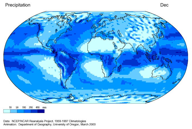
Patterns of precipitation through the year
University of Oregon
Asia, India, and Australia
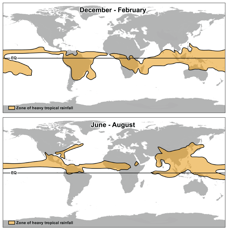
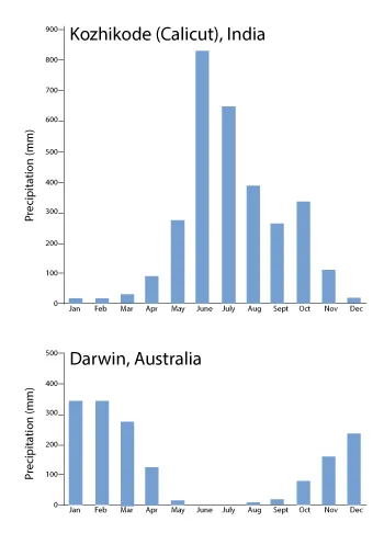
With the world’s strongest monsoons, this region stretches from the South China Sea into the Indian Ocean and includes Asia and the northern end of Australia. From June until September, summer monsoon rains occur in South Asian countries such as Vietnam, Thailand, Cambodia, Bangladesh, Laos, India, and Pakistan. From December until February, the monsoon rains move south of the equator toward Australia while South Asia experiences dry monsoon conditions. There is even an East Asian monsoon that brings summer rain to China, Japan, and Korea, but it is caused by a different type of wind pattern that is associated with the jet stream.

Monsoons bring large amounts of rain to a location, often leading to large-scale vegetation growth.
University of Oregon
The Americas
Monsoon winds in the tropical parts of North America, Central America, and South America cause the amount of rainfall to vary with the seasons, even in areas where precipitation is plentiful and rainforests thrive. From June to August, which are summer months in the Northern Hemisphere, there is more rainfall north of the equator in Costa Rica, Nicaragua, Panama, and western Mexico. From December to February there is more rainfall south of the equator in Brazil. The North American monsoon does bring moisture from the warm waters of the Pacific into the US Southwest, but its peak rainfall occurs in Mexico, and the US states of Arizona and New Mexico lie on its periphery. These areas are typically dry but can receive enough rainfall to quell a wildfire if moist monsoon winds blow in summer. An area of summer rainfall along the US East Coast is associated with what some might call a mid-latitude version of monsoon rainfall.
Africa
During Northern Hemisphere summer, the Intertropical Convergence Zone (ITCZ) over Africa lies far north of the equator, just south of the Sahara Desert in an area known as sub-Saharan Africa. Moist winds blow from the Atlantic and produce rain once they reach West Africa in countries such as Mali, Niger, Ghana, and the Ivory Coast. During Southern Hemisphere summer, the ITCZ lies south of the equator and brings rain to southern African countries such as Zimbabwe, Tanzania, Zambia, Malawi, Mozambique, and Uganda. Meanwhile, sub-Saharan Africa becomes particularly hot and dry in winter as air descends from high in the atmosphere to the ground as part of the Hadley Circulation.
Coriolis force changes direction on the equator: It turns winds toward the right in the Northern Hemisphere and to the left in the Southern Hemisphere. So when air crosses the equator as it flows from the cold winter hemisphere toward the ITCZ in the summer hemisphere, it experiences a change in the Coriolis force. This causes the trade winds to reverse direction and blow toward the west in the winter hemisphere and to the east in the summer hemisphere. This seasonal reversal of the winds was historically very important for trade between Africa and Asia. Ships would sail from Asia to Africa in winter and then undertake their return voyage when the summer monsoon changed the wind from westward to eastward.
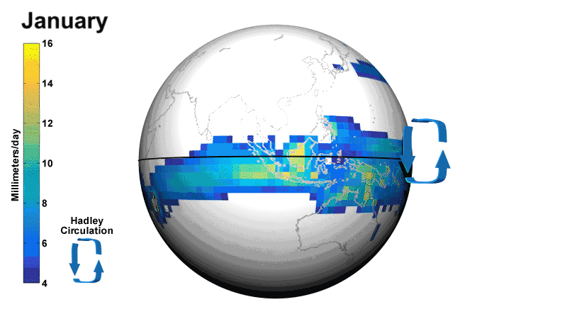
The animation above shows how the ITCZ, winds, and rain patterns change through the months of the year. The summer monsoon is what people often think of as monsoon conditions: large amounts of rain. But the winter monsoon, where dry conditions prevail, is part of the pattern too. During winter, air descends over tropical continents as the part of the Hadley Circulation that is outside of the ITCZ. Descending air causes high pressure and makes clouds and rain uncommon. The dry conditions during winter can even lead to drought if they are too intense or persist for too long.
Monsoons are affected by geography.
Geography affects the amount of rainfall that an area receives as the ITCZ moves through the seasons. For example, during Northern Hemisphere winter, the ITCZ is south of the equator and monsoon rains fall in northern Australia. Low-level winds blow south toward the ITCZ, picking up moisture as they move over the warm, tropical ocean. Meanwhile in India, dry air descending over land means there is little precipitation.
During Northern Hemisphere summer, the ITCZ is north of the equator and monsoon rains fall in India and other parts of South Asia as winds blow north from the tropical ocean to the land, while northern Australia experiences very dry conditions as air descends.
The location of monsoon rainfall is affected by the fact that land can’t hold onto heat as well as the ocean. When intense summer sunlight hits land, its energy is absorbed and transferred quickly back into the atmosphere. When summer sunlight hits the ocean, the Sun’s energy is held by water and can be mixed downward and stored tens to hundreds of feet below the surface. This means that in summer, air over land is heated more than air over ocean, which shifts the ITCZ toward land regions. In regions where continents lie north or south of the equator, as in Asia and Australia, this causes the ITCZ to shift farther off the equator during the summer season.
What affects the amount of rain?
There is year-to-year variation in the amount of monsoon rainfall during summer. For example, researchers have found that during El Niño conditions, when the Pacific Ocean is particularly warm near the equator, there is typically less rainfall during the summer monsoon in India. During La Niña conditions, when the Pacific Ocean is cool, there is more rain during the summer monsoon in India. While this is a general pattern, it cannot be used to indicate exactly how much rain will fall in India in any particular summer. In fact, the strongest El Niño event in the 20th century (1997 – 1998) had little effect on the Indian monsoon. So, there must be other influences on the amount of rainfall, too. This is an area of active research.
Climate change may be changing monsoons.
According to most computer simulations of Earth’s climate over the next 50 to 100 years, there will be an increase in rainfall in most monsoon regions as climate warms due to the rising levels of atmospheric greenhouse gases such as carbon dioxide. Rains will likely increase in wet regions as the climate warms if the wind patterns do not change, because warm air can hold more water and more water vapor in the atmosphere will produce more rain in the ITCZ. Over ocean, where there is abundant water supply for the atmosphere, this is quite likely, but it is less clear how the amount of rain may change over land as the climate warms. Whether or not winds will change enough to have a large effect on the rainfall is also unclear. During the dry season, land is expected to become drier because evaporation from land will increase in a warmer climate.
At the same time that rainfall is changing due to global climate change, natural year-to-year variability is happening as well. Other changes to the amount of rainfall may be caused by air pollution (such as tiny particles released as coal, oil, and gas are burned). The amount of monsoon rain that falls each year is highly variable, according to records of rain in India collected since the 1880s. In parts of India monsoon rainfall has decreased since 1950. Meanwhile, in the Philippines and other areas of the western North Pacific, the amount of monsoon rain has increased. Weak monsoon rains produced drought and famine over large parts of Africa in the 1970s and 1980s, but the West African monsoon rains have recovered somewhat since then. So there is evidence that monsoons are changing, but researchers are still investigating how the amount of monsoon rainfall will be affected by climate change in the future.
Monsoons Impact People
Impacts on agriculture and economy
Farmers in monsoon regions rely on the wet summer months to grow crops. However the summer monsoon does not always bring the same amount of rainfall, and variations in rain have implications for agriculture and the economy.
For example, in 2009, very little rain fell during the summer monsoon in India. In some areas rainfall was half of what is typical during the wet season and farmers could not plant their crops. Farm animals starved; many were sold for a fraction of what they would have normally been worth because farmers were desperate.
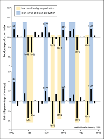
From wheat and rice to vegetables, cotton, and tea, Indian farmers grow a wide range of crops and the country uses more land for crops than any other country in the world (215 million acres, or 87 million hectares). Crops depend on rain and, in India, more than three quarters of the annual rainfall occurs during the four months of the summer monsoon season. But during years when there is less rainfall than usual, crops die in the fields or cannot be planted at all. The graph at the left shows how the amount of grain crops produced by farmers in India (including wheat, rice, and barley) relates to the amount of rainfall. Over half of India’s population works in agriculture, and monsoon rains directly affect their incomes and livelihood. Agriculture adds up to more than 15% of India’s Gross Domestic Product (GDP), which means that when crops fail because of too little rain, the economy suffers.
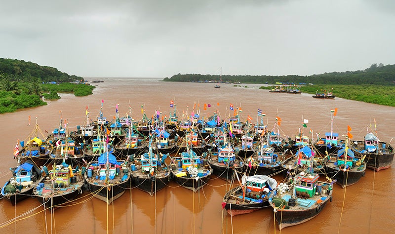
While too little rainfall during the summer monsoon can cause dire conditions for farmers on land, too much rainfall and overly strong winds can make coastal waters unsafe, preventing fishermen throughout South Asia from heading to sea to catch the fish they depend on for income.
Monsoon rains can be harnessed as hydropower, a valuable energy resource. Hydropower currently provides 25% of India’s electricity. Reservoirs are filled during the summer monsoon rains and then the water is gradually released through dams, turning turbines to create electricity year-round. During years when there is little monsoon rainfall, the reservoirs are not replenished, limiting the amount of hydroelectric power produced during the year.
Monsoons and health
Because regions with a monsoon climate have distinctly wet and dry seasons, they are prone to floods and droughts, both of which are hazardous to health.
During summer monsoons, heavy rainfall can cause flooding. Powerful floodwaters can drown victims and damage buildings, leaving people without homes and vulnerable to the elements. During the 2014 summer monsoon in Pakistan and India, nearly 300 people lost their lives because of landslides and home collapses. Australia’s 2011 monsoon flooding caused about US$4.5 billion in damage.
Yet the main health hazards during summer monsoon season are diseases like cholera, dengue, chikungunya, and malaria, as well as stomach and eye infections. Each year, as the summer monsoon season approaches, Indian hospitals prepare for high numbers of patients with these illnesses.
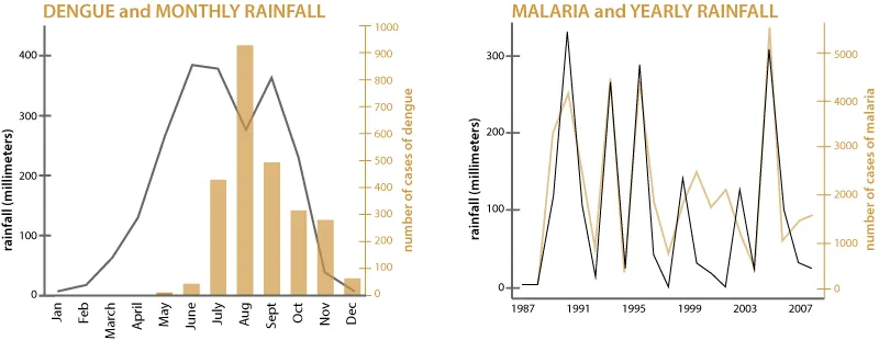
When floods cause water purification systems to become compromised, diseases like cholera can spread through unclean drinking water. Also, mosquitos that carry disease breed in open containers that fill with rainwater — from large water barrels and ponds to small coconut shells. Mosquitos that spread malaria, dengue, and chikungunya are common in the tropics. Because mosquitoes have more places to breed during the summer monsoon rains, there are more mosquitos. That leads to more mosquito bites that spread disease.
During the winter, clouds rarely provide shade and the dry land surface can’t cool off by evaporation, so heat waves are common. At least 2,500 people died in a major heat wave that swept across India in 2015, and over 1,000 died about a month later from a heat wave in Pakistan. Temperatures in New Delhi were near 120°F (almost 50°C). Water is scarce at this time of year, which causes to become common; these diseases spread when there is too little water for proper hygiene.
Meningitis, which kills one in ten victims, spreads during the dry season in sub-Saharan Africa when desert dust becomes airborne and is inhaled. Typically the number of cases drops with the first monsoon rains.
The number of people affected by both the wet and dry monsoon seasons depends on the population of the affected region. For example, Mali in West Africa has a fast-growing population and researchers are investigating how people will cope with the same limited water resources during the dry season as the country’s population grows. Changing Climate, Changing Water Availability, and Human Health
Because the world’s human population is growing rapidly (it is estimated to be between 8 and 11 billion people within the next 50 to 100 years), and all people need clean freshwater to survive, there will be an increasing human demand for freshwater supplies in the future. Because Earth’s climate is warming, freshwater availability may change in the future. Predictions indicate that some regions may have more precipitation, while others may have less. Both situations can lead to changes in human health. Less rainfall may lead to water scarcity. More rainfall may lead to flooding and compromised water treatment systems.
Changes in rainfall, water availability, and water quality occurring because of climate change can lead to changes in the risk of both water-borne and water-washed diseases. In some regions, extreme rainfall events will increase the chances of flooding and the risk of water-borne disease. In some regions, conditions are expected to become more arid with increased rates of evaporation limiting water supply and increasing the risk of water-washed disease. Below is information about both water-borne and water-washed diseases and a summary of how climate change can impact their prevalence according to the IPCC Fourth Assessment Report on Climate Impacts.
Water-Borne Diseases
Water-borne diseases include a variety of ailments that are spread via water containing human or animal waste. Drinking unclean water or eating food that has been cleaned with unclean water can cause a person to ingest the bacteria, viruses, or other microbes that cause water-borne diseases. The culprits that may be present in unclean water include well-known bacteria such as E.coli and Vibrio cholerae, the protozoan Giardia, and the hepatitis A virus. It does not take a huge amount of contamination to impact human health. According to UNICEF, a mere gram of human feces can contain 10000 viruses, 1000000 bacteria, 1000 parasites, 100 parasite eggs.
For example, the illness cholera is caused when Vibrio cholerae bacteria (see image at left) is consumed. The bacteria produce toxins that irritate the small intestine causing diarrhea. Contaminated water is a primary source of Vibrio cholerae bacteria. Cholera is one of the many bacterial infections, collectively known as “diarrheal diseases”, that are prevalent in regions without systems for adequately treating drinking water and dealing with sewage. While diarrhea is, of course, unpleasant, it can also be deadly. If the case of diarrheal disease is severe and left untreated the patient can die from dehydration. Rehydration therapy has decreased the number of deaths from diarrheal diseases, yet the diseases are still a problem in many areas of the world.
The science of water-borne diseases was first recognized in the mid-19th century when the link between cholera and London, England’s untreated water supply became clear. Today, we are aware of the risks of unclean water, yet safe drinking water is still a problem in many areas of the world. According to UNICEF, diarrheal diseases are responsible for about 17% of deaths among children worldwide.
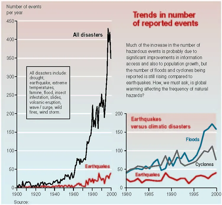
In Africa, the cholera epidemic has lasted for more than 30 years. In North America, Western Europe, and other locations with advanced water treatment systems, the threat of diarrheal diseases is not normally present. However, diarrheal diseases can become a problem in any region of the world if seasonal changes, storms, or other natural disasters compromise water or sewage treatment systems. After Hurricane Katrina caused levees to fail and massive flooding of New Orleans, LA in the fall of 2005, E.coli levels in the floodwaters were of concern and public health officials warned of the threat of diarrheal diseases. At least five people died of diarrheal diseases after the event. The number of reported hazardous events (including severe storms and natural disasters) has increased over the past century (see graph below). There is evidence that weather-based extreme events might increase in frequency, intensity, or both, as our planet continues to warm, thus increasing the threat of water-borne diseases in the future.
Climate change is expected to change the amount of rainfall in areas of the world and to make areas more prone to extreme rainfall events or extreme drought, according to the IPCC Fourth Assessment Report. Extreme events can facilitate water-borne disease outbreaks. Infection with water-borne pathogens has been shown to be higher during the rainy season. Blocked drains, flooded sewers, and other compromised systems during extreme rainfall events can cause an increase in disease. However, there is also evidence that the transmission of water-borne diseases can be higher in the dry season. For example, during the low flow dry season in the Amazon, cholera outbreaks are more likely because stagnant water allows more pathogens to come aboard.
Water-Washed Diseases
In general, washing helps to prevent disease. Diseases that spread because of a lack of washing (i.e., proper hygiene) are called water-washed diseases because they could be washed away. Water-washed diseases include the eye infection trachoma that causes blindness, skin mites called scabies, conjunctivitis, typhus, and lice.
Preventing water-washed diseases in regions of the world where clean water is readily available usually involves educating people on proper hygiene. However, in parts of the world where water is scarce, there may not be enough clean water for adequate washing of people, their clothing, and homes. And washing with unclean water can also cause disease.
More than two billion people live currently in hot and arid regions of the world. In these areas, people are more likely to suffer from higher rates of water-washed diseases related to contamination or insufficient water (as well as a variety of other health issues such as malnutrition.) Many regions that are currently arid are projected to become more arid in the future, increasing the risk of water-washed diseases in these areas.
How Monsoons Form
Monsoons act like giant sea breezes that reverse direction with the changing seasons.
Anatomy of a cyclone
Tropical cyclones are compact, circular storms, generally some 320 km (200 miles) in diameter, whose winds swirl around a central region of low atmospheric pressure. The wind field of a tropical cyclone may be divided into three regions. First is a ring-shaped outer region, typically having an outer radius of about 160 km (100 miles) and an inner radius of about 30 to 50 km (20 to 30 miles). In this region the winds increase uniformly in speed toward the centre. At the centre of a tropical cyclone, however, it is typically around 960 millibars, and in a very intense “super typhoon” of the western Pacific it may be as low as 880 millibars. In addition to low pressure at the centre, there is also a rapid variation of pressure across the storm, with most of the variation occurring near the centre. This rapid variation results in a large pressure gradient force, which is responsible for the strong winds present in the eyewall (described below). Horizontal winds within the eye, on the other hand, are light. In addition, there is a weak sinking motion, or subsidence, as air is pulled into the eyewall at the surface. As the air subsides, it compresses slightly and warms, so that temperatures at the centre of a tropical cyclone are some 5.5 °C (10 °F) higher than in other regions of the storm. Because warmer air can hold more moisture before condensation occurs, the eye of the cyclone is generally free of clouds. Reports of the air inside the eye being “oppressive” or “sultry” are most likely a psychological response to the rapid change from high winds and rain in the eyewall to calm conditions in the eye. The eyewall is the most dangerous and destructive part of a tropical cyclone. It is a ring-shaped region surrounding the eye of the storm, typically located 15 to 30 km (10 to 20 miles) from the center. Within the eyewall, winds reach their maximum speeds, and rainfall is heaviest due to deep convective clouds that rise from near the surface to high altitudes. These strong winds are caused by rapid changes in atmospheric pressure near the eye, creating a significant pressure gradient force. Friction at the surface, in addition to lowering wind speeds, causes the wind to turn inward toward the area of lowest pressure. Air flowing into the low-pressure eye cools by expansion and in turn extracts heat and water vapour from the sea surface. Areas of maximum heating have the strongest updrafts, and the eyewall exhibits the greatest vertical wind speeds in the storm—up to 5 to 10 metres (16.5 to 33 feet) per second, or 18 to 36 km (11 to 22 miles) per hour. While such velocities are much less than those of the horizontal winds, updrafts are vital to the existence of the towering convective clouds embedded in the eyewall. Much of the heavy rainfall associated with tropical cyclones comes from these clouds.
The upward movement of air in the eyewall also causes the eye to be wider aloft than at the surface. Therefore, horizontal circulation in the upper levels of a tropical cyclone is opposite to that near the surface. In addition to deep convective cells (compact regions of vertical air movement) surrounding the eye, there are often secondary cells arranged in bands around the centre. These bands, commonly called rainbands, spiral into the centre of the storm. In some cases the rainbands are stationary relative to the centre of the moving storm, and in other cases they seem to rotate around the centre. The rotating cloud bands often are associated with an apparent wobbling of the storm track. If this happens as the tropical cyclone approaches a coastline, there may be large differences between the forecast landfall positions and actual landfall.Also called: typhoon or hurricaneRelated Topics: rainbandoutflowinfloweyewalleye
As a tropical cyclone makes landfall, surface friction increases, which in turn increases the convergence of airflow into the eyewall and the vertical motion of air occurring there. The increased convergence and rising of moisture-laden air is responsible for the torrential rains associated with tropical cyclones, which may be in excess of 250 mm (10 inches) in a 24-hour period. At times a storm may stall, allowing heavy rains to persist over an area for several days. In extreme cases, rainfall totals of 760 mm (30 inches) in a five-day period have been reported.
Life of a cyclone

A circulation system goes through a sequence of stages as it intensifies into a mature tropical cyclone. The storm begins as a tropical disturbance, which typically occurs when loosely organized cumulonimbus clouds in an easterly wave begin to show signs of a weak circulation. Storms showing counter-clockwise rotation with wind speeds up to 38 km (23.6 miles) per hour are classified as a tropical depressions. If the circulation continues to intensify and the wind speeds exceed 63 km (39 miles) per hour, then the system is called a tropical storm. Once the maximum wind speed exceeds 119 km (74 miles) per hour, the storm is classified as a tropical cyclone.
There are six conditions favourable for this process to take place. The conditions are listed first below, and then their dynamics are described in greater detail:
- The temperature of the surface layer of ocean water must be 26.5 °C (80 °F) or warmer, and this warm layer must be at least 50 metres (150 feet) deep.
- A preexisting atmospheric circulation must be located near the surface warm layer.
- The atmosphere must cool quickly enough with height to support the formation of deep convective clouds.
- The middle atmosphere must be relatively humid at a height of about 5,000 metres (16,000 feet) above the surface.
- The developing system must be at least 500 km (300 miles) away from the Equator.
- The wind speed must change slowly with height through the troposphere—no more than 10 metres (33 feet) per second between the surface and an altitude of about 10,000 metres (33,000 feet).
Formation
As the warm, moist air rises, it expands and cools, quickly becoming saturated and releasing latent heat through the condensation of water vapour. The column of air in the core of the developing disturbance is warmed and moistened by this process. The temperature difference between the warm, rising air and the cooler environment causes the rising air to become buoyant, further enhancing its upward movement.
If the sea surface is too cool, there will not be enough heat available, and the evaporation rates will be too low to provide the tropical cyclone enough fuel. Energy supplies will also be cut off if the warm surface water layer is not deep enough, because the developing tropical system will modify the underlying ocean. If the resulting mixing brings cool water from below the surface layer to the surface, the fuel supply for the tropical system will be removed.
The vertical motion of warm air is by itself inadequate to initiate the formation of a tropical system. However, if the warm, moist air flows into a preexisting atmospheric disturbance, further development will occur. The decreasing pressure causes the surface winds to increase, which in turn increases the vapour and heat transfer and contributes to further rising of air. The warming of the core and the increased surface winds thus reinforce each other in a positive feedback mechanism.
Intensification
The dynamics of a tropical cyclone rely on the exterior of a storm being cooler than its core, so it is necessary that the temperature of the atmosphere drop sufficiently rapidly with height. The warm, saturated air rising in the centre of the circulation tends to keep rising as long as the surrounding air is cooler and heavier. This vertical movement allows deep convective clouds to develop. The rising air in the core also draws in some air from the surrounding atmosphere at altitudes of around 5,000 metres (16,000 feet). If this external air is relatively humid, the circulation will continue to intensify. If it is sufficiently dry, then it may evaporate some of the water drops in the rising column, causing the air to become cooler than the surrounding air. This cooling will result in the formation of strong downdrafts that will disrupt the rising motion and inhibit development.
For the development of the rapid rotation characteristic of tropical cyclones, the low-pressure centre must be located at least 500 km (300 miles) away from the Equator. A final requirement for the intensification of tropical cyclones is that there must be little change in the wind speed with height above the surface. If the winds increase too much with altitude, the core of the system will no longer be vertically aligned over the warm surface that provides its energy. The area being warmed and the surface low-pressure centre will move apart, and the positive feedback mechanism described above will be suppressed. Conditions in the tropics that encourage the development of tropical cyclones include a typically minor north-to-south variation in temperature. This relative lack of a temperature gradient causes wind speed to remain relatively constant with height.
Dissipation
Tropical cyclones dissipate when they can no longer extract sufficient energy from warm ocean water. As mentioned above, a tropical cyclone can contribute to its own demise by stirring up deeper, cooler ocean waters. In addition, a storm that moves over land will abruptly lose its fuel source and quickly lose intensity.
A tropical cyclone that remains over the ocean and moves into higher latitudes will change its structure and become extratropical as it encounters cooler water. An extratropical cyclone typically has a higher central pressure and consequently has lower wind speeds. Extratropical cyclones, which are fueled by a north-to-south variation of temperature, weaken and dissipate in a few days.
Tropical cyclone damage
Horizontal wind
In the most intense tropical cyclones, sustained winds may be as high as 240 km (150 miles) per hour, and gusts can exceed 320 km (200 miles) per hour. The length of time that a given location is exposed to extreme winds depends on the size of the storm and the speed at which it is moving. During a direct hit from a tropical cyclone, an area may endure high winds for several hours. In that time even the most solidly constructed buildings may begin to suffer damage. In the most intense tropical cyclones, sustained winds may be as high as 240 km (150 miles) per hour, and gusts can exceed 320 km (200 miles) per hour. The length of time that a given location is exposed to extreme winds depends on the size of the storm and the speed at which it is moving. During a direct hit from a tropical cyclone, an area may endure high winds for several hours. In that time even the most solidly constructed buildings may begin to suffer damage. The force of the wind increases rapidly with its speed. A building with a large surface area facing the wind may be subjected to immense forces. Some of the local variability in damage that is often observed during tropical cyclones is due to the direction that buildings face relative to the prevailing wind.
Horizontal winds associated with a tropical cyclone vary in strength depending on the area of the storm in which they occur. The strongest winds are located in the right-forward quadrant of the storm, as measured along the line that the storm is moving. The intensification of winds in this quadrant is due to the additive effect of winds from the atmospheric flow in which the storm is embedded. For example, in a hurricane approaching the East Coast of the United States, the highest and most damaging winds are located to the northeast of the storm centre. The horizontal winds within a tropical cyclone vary in intensity based on their location within the storm. The most powerful winds are found in the right-forward quadrant, relative to the storm’s direction of movement.
The force exerted by wind increases significantly with speed. Winds of 100 km/h exert a pressure of 718 pascals, while doubling the wind speed to 200 km/h increases the pressure nearly fivefold to 3,734 pascals. Buildings with large surface areas facing the wind can experience immense forces. Localized variations in damage during tropical cyclones are often attributed to the orientation of buildings relative to the prevailing winds. A tornado is a violently rotating column of air that is in contact with both the surface of the Earth and a cumulonimbus cloud or, in rare cases, the base of a cumulus cloud. Tornadoes are often referred to as twisters or cyclones, although the word cyclone is used in meteorology to name a storm system with a closed circulation around a center of low atmospheric pressure.
Characteristics of Tornadoes
- Formation: Tornadoes typically form during severe thunderstorms, particularly supercells, which are thunderstorms characterized by a deep, persistently rotating updraft called a mesocyclone. The exact mechanisms that cause a mesocyclone to spawn a tornado are still an area of active research, but they often involve complex interactions of wind shear, temperature gradients, and atmospheric instability.
- Appearance: Tornadoes can vary greatly in appearance. They are most often visible as a condensation funnel extending from the cloud base to the ground. This funnel is made visible by condensed water vapor and debris picked up from the ground. Some tornadoes are narrow and rope-like, while others can be wide and wedge-shaped. In some cases, the rotating column of air may not be visible, but its presence is indicated by the swirling debris at ground level.
- Wind Speeds: Wind speeds within a tornado can range from about 40 mph (64 km/h) to over 200 mph (322 km/h), and in extreme cases, can exceed 300 mph (483 km/h). These extreme wind speeds are what give tornadoes their destructive power.
- Size: Tornadoes can range in width from a few yards to over a mile (1.6 km). Their path length can also vary significantly, from a few hundred yards to over 100 miles (160 km).
- Duration: The lifespan of a tornado can range from a few seconds to over an hour.
Tornado Intensity and Measurement
The intensity of a tornado is measured using the Enhanced Fujita (EF) Scale, which rates tornadoes on a scale from EF0 (weakest) to EF5 (strongest) based on the damage they cause. The scale estimates wind speeds based on the observed damage to structures and vegetation.
- EF0: Light damage, broken branches, loose signs. (65-85 mph)
- EF1: Moderate damage, overturned mobile homes, damaged roofs. (86-110 mph)
- EF2: Considerable damage, unroofed houses, large trees snapped or uprooted. (111-135 mph)
- EF3: Severe damage, entire stories of well-constructed houses destroyed, trains overturned. (136-165 mph)
- EF4: Devastating damage, well-constructed houses leveled, cars lifted and thrown. (166-200 mph)
- EF5: Incredible damage, strong frame houses swept away, steel-reinforced concrete structures badly damaged. (>200 mph)
Tornado Occurrence
Tornadoes can occur in many parts of the world, but they are most common in the United States, particularly in a region known as Tornado Alley, which stretches across the central plains. Other areas with significant tornado activity include parts of Canada, Australia, Europe, and Asia. The peak season for tornadoes in the United States is typically spring, from March to May, but they can occur at any time of year.
Tornado Safety
When a tornado warning is issued, it is crucial to take immediate action to ensure safety. This typically involves seeking shelter in a basement, storm cellar, or an interior room on the lowest floor of a sturdy building, away from windows. Most tropical disturbances that reach storm intensity have tornadoes associated with them when they make landfall, though the tornadoes tend to be weaker than those observed in the Midwestern United States. The number of tornadoes varies, but about 75 percent of tropical cyclones generate fewer than 10. The largest number of tornadoes associated with a tropical cyclone was 141, reported in 1967 as Hurricane Beulah struck the Texas Gulf Coast in the United States.
Tornadoes can occur in any location near the centre of the storm. At distances greater than 50 km (30 miles) from the centre, they are confined to the northeast quadrant of Northern Hemisphere storms and to the southwest quadrant of Southern Hemisphere storms. How the tornadoes are generated is not clear, but surface friction probably plays a role by causing the wind to slow as the tropical cyclone makes landfall. Wind speeds near the surface decrease while those at higher levels are less affected, setting up a low-level horizontal rotation that becomes tilted into the vertical by updrafts, thus providing the concentrated spin required for a tornado.
tropical cyclone
A tropical cyclone is an intense circular storm that forms over warm tropical oceans. It is characterized by low atmospheric pressure, high winds, and heavy rain, drawing energy from the sea surface. When wind speeds exceed 119 km (74 miles) per hour, a weaker tropical storm matures into a tropical cyclone, also known as a hurricane, typhoon, or cyclone depending on the region. These storms can have winds exceeding 240 km (150 miles) per hour and can cause a devastating storm surge, an elevation of the sea surface that can reach 6 meters (20 feet).
The formation of a tropical cyclone requires specific conditions:
- Ocean surface temperatures of at least 26.5 °C (80 °F) to a depth of 50 meters (150 feet).
- A pre-existing atmospheric circulation near the warm ocean layer.
- An atmosphere that cools quickly with height to support deep convective clouds.
- A relatively humid middle atmosphere at about 5,000 meters (16,000 feet).
- A location at least 500 km (300 miles) from the Equator.
- Slow wind speed changes with height through the troposphere.
The storm begins as a tropical disturbance, evolving into a tropical depression with winds up to 38 km (23.6 miles) per hour, then a tropical storm with winds over 63 km (39 miles) per hour, and finally a tropical cyclone when winds surpass 119 km (74 miles) per hour. More specifically, wind speed must temporarily peak above 16 knots (about 30 km per hour) after accelerating by at least 9–10 knots (about 17–19 km per hour) to qualify as a gust. Wind shear, rapid change in wind velocity or direction. A very narrow zone of abrupt velocity change is known as a shear line. Sometimes thunderstorms will produce intense downdrafts that create damaging winds on the ground. Downbursts are a serious hazard to aircraft, especially during takeoffs and landings, because they produce large and abrupt changes in the wind speed and direction near the ground. Occasionally the momentum of an updraft carries it into the stratosphere, but after a short distance the air in the top of the updraft becomes cooler and heavier than the surrounding air, and the overshoot ceases. When a cumulonimbus cloud reaches a capping inversion or the tropopause, it spreads outward and forms the anvil cloud so characteristic of most thunderstorms. The winds at anvil altitudes typically carry cloud material downwind, and sometimes there are weak cells of convection embedded in the anvil. Turbulence can be quantified in various ways, but frequently a g unit, equal to the acceleration of gravity (9.8 metres per second squared, or 32.2 feet per second squared), is used. A gust of 1 g will cause severe aircraft turbulence. In the upper part of violent thunderstorms, vertical accelerations of about 3 g have been reported.
Movement of thunderstorms
The motion of a thunderstorm across the land is determined primarily by the interactions of its updrafts and downdrafts with steering winds in the middle layers. When winds are light, an individual cell may move very little, less than two kilometres, during its lifetime; however, in a larger storm, new cells triggered by the outflow from downdrafts can give the appearance of rapid motion. In large, multicell storms, the new cells tend to form to the right of the steering winds in the Northern Hemisphere and to the left in the Southern Hemisphere. A rough estimate of the total energy in a thunderstorm can be made from the total quantity of water that is precipitated by the cloud. In a typical case, this energy is about 107 kilowatt-hours, roughly equivalent of a 20-kiloton nuclear explosion (though it is released over a broader area and in a longer span of time). A large, multicell storm can easily be 10 to 100 times more energetic. When such air hits the ground, it usually moves outward ahead of the storm at a higher speed than the storm itself. The outspreading downdraft air forms a pool some 500 to 2,000 metres (about 1,600 to 6,500 feet) deep, and often there is a distinct boundary between the cool air and the warm, humid air in which the storm developed. The passage of such a gust front is easily recognized as the wind speed increases and the air temperature suddenly drops. Over a five-minute period, a cooling of more than 5 °C (9 °F) is not unusual, and cooling twice as great is not unknown. In extreme circumstances, the gust front produced by a downburst may reach 50 metres (about 160 feet) per second or more and do extensive damage to property and vegetation. Severe winds occur most often when organized lines of thunderstorms develop where the middle-level winds are very strong. Under such conditions, people might think the winds were caused funnel cloud is not observed, the character of the wind damage can indicate the source. Tornadoes blow debris in a tight circular pattern, whereas the air from a thunderstorm outflow pushes it mostly in one direction.
By the time the cool air arrives, usually is reaching the surface. Sometimes all the raindrops evaporate while falling, and the result is a dry thunderstorm. At the other extreme, severe multiple-cell and supercell storms can produce torrential rain and and cause flash floods.