The number of tourists coming to the Himalayas is very high, and the pressure is also high,” Dr Mehta said.

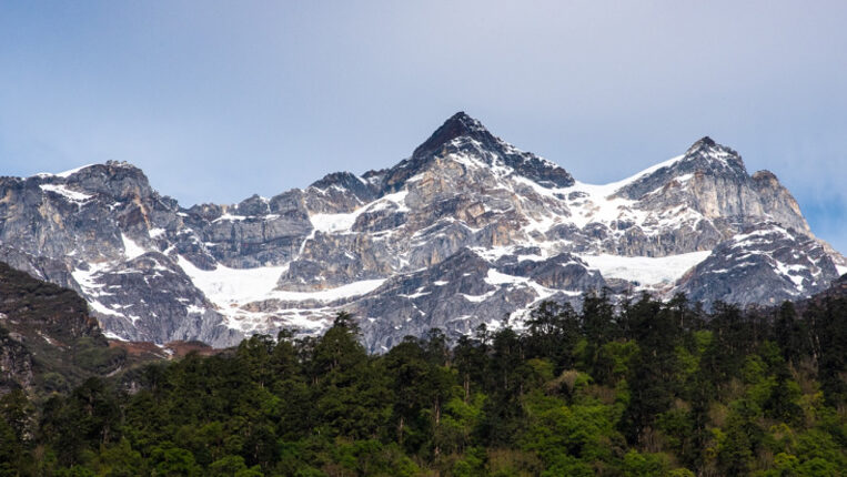
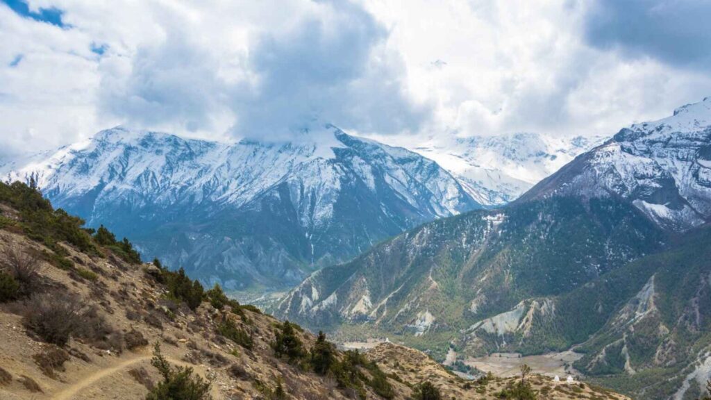
DEHRADUN: Often described as the world’s “Third Pole”, the Himalayas are showing signs of stress, with rising temperatures, erratic snowfall, shrinking glaciers and growing human pressure threatening one of Asia’s most vital ecological systems.
Environmental scientist and academic Prof SP Sati said the health of the Himalayas is deteriorating rapidly due to a combination of climate change, altered weather patterns and mounting pollution.
“The Himalayas today face several major challenges. Climate change, changes in the seasonal cycle and plastic waste are directly affecting the glaciers,” Prof Sati said.
Scientists warn that the crisis is not confined to the mountains alone. Himalayan glaciers feed several major Asian rivers and support millions of people downstream. Any disruption in this fragile system could have serious consequences for water security, agriculture, weather patterns and disaster risks across the region. Dr Manish Mehta, senior scientist and glaciologist at the Wadia Institute of Himalayan Geology, said tourist pressure has increased sharply across the Himalayan belt, including Uttarakhand, Himachal Pradesh and Ladakh.
“The number of tourists coming to the Himalayas is very high, and the pressure is also high,” Dr Mehta said.
According to experts, nearly 12,000 small and large glaciers exist across the Himalayan region. Many of them are retreating at an alarming pace. Studies have shown that glaciers are shrinking by 1 to 20 metres every year, depending on their size, location and exposure.
Dr Mehta said glaciers from Uttarakhand and Himachal Pradesh to Ladakh and the North-East are retreating.
One of the biggest concerns is the change in snowfall patterns. Earlier, heavy snowfall during December, January and February helped glaciers accumulate and retain ice. Now, snowfall is shifting towards March, April and May. The Himalayas are warming faster than the global average, driving rapid glacial retreat, expanding hazardous glacial lakes, and causing ecological shifts. These changes threaten the water security of 1.3 billion people living downstream and amplify the risk of catastrophic flash floods and landslides across the region. Climate Change Impacts on the Himalayas and Community Solutions in South Asia greater Himalayan region’s vast glaciers and permafrost are crucial for ten major Asian rivers, supporting over 1.3 billion livelihoods. The Intergovernmental Panel on Climate Change (IPCC) has confirmed significant snow cover and glacier declines since the 1970s, with further reductions expected. These impacts are already being seen, with glacial retreat, water scarcity, biodiversity loss, and natural disasters such as floods, landslides, and droughts threatening the fragile ecosystems of the region and the livelihoods of millions who depend on it.
The #Himalayas often referred to as the “Third Pole,” are inherently vulnerable to heavy rains, flash floods, landslides, and other hazards due to being new mountains that are still growing and are seismically active. Climate change has exacerbated this vulnerability, acting as a force multiplier and making natural disasters more severe. The rapid reduction in glaciers, in particular, has profound implications for downstream water resources and the region’s environment.
Warming has surpassed the global average, particularly in Nepal, where extreme weather events like hailstorms, floods, landslides, and droughts are increasingly common. Climate-induced migrations are rising, leading to losses in human life, crops, and infrastructure. These impacts are superimposed on a variety of other environmental and social stresses, many of which are already severe. Human interventions such as dams, hydropower projects, highways, mining, deforestation, buildings, unregulated tourism, and pilgrimage have further increased the fragility of the mountains. The Himalayas are inherently vulnerable to heavy rains, flash floods, landslides, etc., as these are new mountains which are still growing and are seismically very active. Climate change has added another layer of vulnerability. It is acting as a force multiplier and making landslides, flash floods and cloudbursts more disastrous. The most widely reported impact is the rapid reduction in glaciers, which has profound future implications for downstream water resources. The impacts of climate change are superimposed on a variety of other environmental and social stresses, many already recognized as severe. The Himalayan region is the source of ten of the largest rivers in Asia. The basins of these rivers are inhabited by 1.3 billion people and contain seven megacities. Natural resources in these basins provide the basis for a substantial part of the region’s total GDP and important environmental services, which are also of importance beyond the region. Due to ill-thought human interventions – dams, hydropower projects, highways, mining, deforestation, buildings, unregulated tourism, and pilgrimage – the fragility of the mountains has increased.
Key Indicators of Climate Breakdown
- Shrinking and Retreating Glaciers: Glaciers across the region are deteriorating at alarming rates. For example, the Gangotri Glacier has retreated over 1,500 meters since 1935, drastically altering seasonal water availability. Climate change in the Himalayan region: susceptible impacts on environment and human settlements the Himalayan region, home to the world’s highest mountain ranges, is an ecological and cultural hotspot crucial for the livelihood of nearly two billion people downstream. However, it faces significant vulnerabilities due to climate change, which threatens its fragile ecosystems and socio-economic frameworks. Notably, environmental risks include glacier retreat, biodiversity loss, and shifting water supplies, with adverse consequences for water availability and agricultural productivity. These climatic shifts exacerbate social and economic pressures, disrupting agro-based livelihoods, damaging infrastructure, and intensifying the frequency and severity of extreme weather events. This study highlights the urgent need for region-specific, sustainable development policies that integrate improved climate monitoring, ecosystem-based adaptation, and the synergy between indigenous knowledge and scientific advancements. A comprehensive framework is proposed to safeguard both ecological and socio-economic resilience in the face of ongoing climate change challenges in the Himalayas.
Himalayan glaciers store and release seasonal meltwater that feeds into river flow in its dry season, reduces the availability of water supply and helps mitigate against drought. This supports food security for millions through agricultural irrigation and hydropower generation. The region also has a hand in the monsoon, which acts as a climatic buffer by moderating seasonal rainfall patterns across Asia. Wadia Institute of Himalayan Geology”’, Dehradun is an autonomous research institute for the study of under the Department of Science and Technology (India) Department of Science and Technology, Ministry of Science and Technology (India)|Ministry of Science and Technology, Government of India. It was established in June 1968 in the Botany Department of Delhi University, the Institute was shifted to Dehradun, Uttarakhand during April 1976. Institute of Himalayan Geology, Dehradun, Uttarakhand (INDIA) Wadia Institute of Himalayan Geology, Dehradun. Department of Science and Technology (India), Department of Science and Technology, Govt. of India. Status of geo-scientific research at Wadia Institute of Himalayan Geology, Dehradun during 2020–2023. Proceedings of the Indian National Science Academy of the institute also has three field search stations, at Naddi-Dharamshala, Dokriani Bamak Glacier Station and itanagar in Arunachal Pradesh. The institute has its origins in department of Geology at University of Delhi, after being shifted to dehradun it was initially named as the Institute of Himalayan Geology, renamed in 1976 as the Wadia Institute of Himalayan Geology in memory of its founder, late Prof. Darashaw Nosherwan Wadia (F.R.S. and National Professor), in honor to his contributions to the geology of the Himalayas. During the last quarter century the Institute has grown as a center of excellence in the field Himalayan Geology and is recognise as a National Laboratory of international repute with advanced laboratories and other infrastructural facilities for undertaking higher level of research in the country. The institute is involved in both basic and applied research to unravel the Geodynamics of the mighty Himalaya, which covers a wide spectrum of Geoscientific disciplines: petrology, geochemistry, structural geology, geophysics, sedimentology, biostratigraphy, earthquake geology, geomorphology, environment & engineering geology, quaternary geology, hydrology, glaciology, etc. Wadia Institute alone studies Himalayan rocks, relics.
The museum offers a glimpse of the mighty Himalaya; its origin, evolution in time and space, natural resources, life in the geological past, earthquakes and environmental aspects. Basic objective in organizing the museum is to educate students and general public as well as to highlight the Institute activities. The museum is very popular among children and tourists and is a center of attraction of large number of student visitors from different universities, local schools general public as well as international visitors. Students in large groups from different schools, universities, colleges and from other institutions visited the Museum and guided tours were provided to them. A relief model of the Himalaya and paintings depicting the impact of human activities on the environment displayed in the Museum remained a point of attraction for the visitors. Also, over the years visitors from US, Austria, U.K, Ukraine, Thailand, Australia, England, Japan, Nepal, France, Russia, Moscow, Israel and Canada visited the Museum.
Center for Glaciology
The Centre for Himalayan Glaciology was inaugurated by the Hon’ble Minister for Science and Technology and Earth Sciences, Shri Prithviraj Chavan on 4 July 2009 in the benign presence of the Secretary, DST, Dr. T. Ramasami and Joint Secretary, Shri Sanjiv Nair. In addition, the Centre shall take up programmes of capacity building in this very specialized field, which will eventually nurture the independent Indian Institute of Glaciology.
Student Programmes/Fellowships
- Fellowships
- Institute Fellowships:
The Institute provides two categories of Institute Fellowships every year: a) Junior Research Fellowship b) Institute Research Associate
- Project Fellowship
Project assistantships are advertised as and when vacancies in Institute projects or externally funded projects arise.
Consultancy & Advisory Services
The Wadia Institute of Himalayan Geology provides consultancy and advisory services on small scale to various organisations for purpose of road alignment, site selection for bridges and their foundation, slope stability and control of landslides, site selection for deep tubewells, geotechnical feasibility of major and minor hydel projects and related structures, passenger and haulage ropeways, seismotectonics of hydel projects and environmental feasibility of developmental projects etc. Scientists Warn Himalayan Rivers Are Becoming Increasingly Unstable new study suggests changes in Himalayan rivers could reshape river channels, increase hazards, and create new challenges for communities and infrastructure that depend on meltwater-fed river systems.
Warming is making Himalayan rivers more unstable, with potentially serious consequences downstream.
The Himalayas do more than tower over Asia. They help store and release the water that feeds some of the continent’s most important rivers, supporting nearly 2 billion people from mountain valleys to densely populated plains. Now, a new study suggests that this frozen water system is becoming less stable as the climate warms. Using satellite images and field observations from 1980 to 2020, researchers found that Himalayan rivers are shifting more quickly as glaciers melt and frozen ground thaws. These changes can make rivers more unpredictable, increasing the risk of flooding, erosion, and damage to roads, bridges, farms, and riverside communities.
Temperatures in the Himalayas have climbed nearly twice as fast as the global average since the 1980s. That warming is changing how water and sediment move through the mountains. More meltwater can give rivers extra energy, while thawing ground can weaken the banks that help keep channels in place.
Professor Chengshan Wang and Dr. Zhongpeng Han of the China University of Geosciences, Beijing, worked with Dr. Lin Zhipeng of Sichuan University to investigate how these changes are affecting three major Himalayan river basins.
Tracking River Movement Over Four Decades
In a study published in Science on May 14, 2026, the researchers examined Himalayan river changes from 1980 to 2020. They investigated whether glacier melt and thawing frozen ground driven by climate change are speeding up river movement and reshaping channels. River movement offers clues about how waterways respond to environmental pressure. It also influences flooding, erosion, sediment transport, and riverbank stability. “The upper high Himalayas stand out as a region where climate warming and channel migration interact strongly, providing an opportunity to study the effects of a warming climate on river dynamics such as river meandering and planform morphodynamics,” says Dr. Han.
The team used satellite imagery and field observations to study 1,079 river bends along about 1,582 km (983 miles) of river channels flowing through frozen ground. Many of these bends could shift freely because nearby landforms did not restrict them. The researchers measured how far the bends moved and documented other changes, including cutoffs, in which a river carves a shorter path and leaves part of its old channel behind; avulsions, in which a river abruptly moves into a new channel; and channel-pattern transitions, in which rivers shift between single channels and networks of interconnected channels.
The results showed a sharp rise in river movement over the 40-year study period. Overall migration rates increased by 33% from 1980 to 2020, while freely moving river bends increased by nearly 97%. Cutoffs, avulsions, and channel-pattern changes also became more common during the period studied.
Why Himalayan Rivers Are Becoming More Unstable
The researchers linked these shifts to rising temperatures, glacier melt, and thawing frozen ground across the Himalayas. Warmer conditions are sending more water and sediment into rivers while also weakening frozen riverbanks. Together, these effects appear to be making rivers less stable and more likely to move. The study also found that Himalayan rivers respond to warming differently than Arctic rivers. In Arctic regions, vegetation can help stabilize riverbanks and slow channel movement. In the Himalayas, sparse vegetation leaves thawing riverbanks more exposed to erosion and collapse, making the region especially vulnerable to climate-driven river changes.
The researchers warn that faster river movement could affect water security, flood hazards, sediment-related risks, and infrastructure built along riverbanks. “For the billions who rely on Himalayan water sources, the acceleration of river dynamics documented in our study poses implications for water security, sediment-related hazards, and the stability of riparian infrastructure,” says Prof. Wang.
The findings point to a growing need for long-term planning that accounts for climate-driven river changes, especially in water management, flood control, and infrastructure development across the Himalayan region.
Reference: “Accelerated Himalayan river meandering and dynamics due to climate change” by Zhipeng Lin, Zhongpeng Han, David R. Montgomery, Waqas Ul Hussan, Lars Lønsmann Iversen, Mette Bendixen, Xu Xu, Ling Yao, Yalige Bai, Xinhang Wang, Er Huang, Xingnian Liu and Chengshan Wang, 14 May 2026, Science. This research was supported by the National Natural Science Foundation of China (grant no. 42488201); the Second Tibetan Plateau Scientific Expedition and Research Program (grant no. 2019QZKK0204); the Fundamental Research Funds for the Central Universities (grant no. 2652023001) grants; the National Natural Science Foundation of China (grant no. 42402127); the Postdoctoral Fellowship Program and China Postdoctoral Science Foundation (grant no. BX20240237); the Sichuan Provincial Natural Science Foundation (grant no. 2026NSFSC1158); the IAS Postdoctoral Grant Scheme, the Sichuan Science and Technology Program (grant no. 2023NSFSC1989); the Sichuan University Postdoctoral Interdisciplinary Innovation Fund; and the Sichuan University SKHL Open Fund (grant no. SKHL2221).
Erratic Snowfall Patterns: Historically, heavy snowfall in December and January sustained glacier accumulation. Precipitation has increasingly shifted toward rain, or late-season snow in March and May. This severely diminishes natural water storage capacity.
Scientists concerned as Himalayas show signs of climate breakdown number of tourists coming to the Himalayas is very high, and the pressure is also high,” Dr Mehta said.
DEHRADUN: Often described as the world’s “Third Pole”, the Himalayas are showing signs of stress, with rising temperatures, erratic snowfall, shrinking glaciers and growing human pressure threatening one of Asia’s most vital ecological systems.
Environmental scientist and academic Prof SP Sati said the health of the Himalayas is deteriorating rapidly due to a combination of climate change, altered weather patterns and mounting pollution.
“The Himalayas today face several major challenges. Climate change, changes in the seasonal cycle and plastic waste are directly affecting the glaciers,” Prof Sati said.
Scientists warn that the crisis is not confined to the mountains alone. Himalayan glaciers feed several major Asian rivers and support millions of people downstream. Any disruption in this fragile system could have serious consequences for water security, agriculture, weather patterns and disaster risks across the region.
Unstable River Systems: Research analyzing forty years of satellite imagery reveals a 33% increase in river migration rates. Thawing frozen ground weakens riverbanks, turning predictable waterways into erratic hazards.
The “Greening” of High Altitudes: Alpine vegetation is creeping higher up the mountains as snow cover thins. While seemingly positive, this invasive greening disrupts natural snowpack storage and shifts fragile high-altitude biodiversity. Scientists see more vegetation in the Himalayas, but it is not good news, because that extra “green” can disrupt water, snow, and high-mountain biodiversity the biggest climate warning from the Himalaya was easy to picture because glaciers were shrinking on the roof of Asia. Now, researchers are pointing to a quieter signal, one that can look almost harmless from a distance.
The planet’s green belt is shifting, and scientists are concerned: terrestrial vegetation is moving northeast at an accelerating rate what if you could weigh every leaf on Earth and watch the balance point wander across the oceans? Using decades of satellite data, researchers say that point swings seasonally from the North Atlantic near Iceland in mid-July to waters off Liberia around March, and its long-term path has been drifting toward the northeast.

Global greening: The Earth’s green wave is shifting develop a novel method to track global vegetation states – and discover a shift towards the north-east. A team of scientists led by the German Centre for Integrative Biodiversity Research (iDiv), the Helmholtz Centre for Environmental Research (UFZ), and Leipzig University has developed a new method to track the Earth’s greenness – a key indicator of vegetation health and activity – by calculating its centre of mass.
Lead author Prof. Miguel Mahecha explains: “Imagine holding a perfectly round globe in your hands and attaching small weights to it, each representing the green leaves at every point on the Earth’s surface. If you then carefully place this globe into calm water, the centre of mass will always point downward.” Mahecha is a researcher at Leipzig University, the Helmholtz Centre for Environmental Research (UFZ), and a member of iDiv.
Earth’s green centre shifts continuously
Using satellite observations and model data, the researchers tracked how this “green centre” shifts over time. In rhythm with the seasons, vegetation greenness moves like a green wave from north to south and back each year. By tracking the centre of this wave – its direction and velocity – the team found it oscillating between its northernmost position in mid-July in the North Atlantic near Iceland and its southernmost position off the coast of Liberia in March.
The study, published in the journal PNAS, sheds new light on global greening – a less widely known aspect of global change referring to the overall increase in vegetation density worldwide. Like climate and biodiversity change, global greening is largely driven by human activities. Rising atmospheric CO₂ acts as a fertiliser, enhancing photosynthesis, while higher temperatures extend growing seasons in many regions.
When analysing changes in the green wave over several decades, the researchers detected a consistent northward shift across all seasons. Contrary to their expectations, they did not observe a southward shift during the Southern Hemisphere summer.
Unexpected shift to the north
“This was a huge surprise to us,” says Mahecha. “Longer growing seasons and warmer winters in the Northern Hemisphere, which allow vegetation to remain slightly greener for longer, may be driving the Earth’s overall greening shift throughout the year. However, this is a hypothesis that we need to explore further.”
In addition to the northward movement, the team also identified a distinct eastward shift. According to the researchers, this pattern is likely linked to pronounced greening hotspots in eastern regions such as India, China, and Russia.
Tracking the Earth’s seasonal greening and effectively measuring how fast and in which direction it is changing connects multiple facets of global change, including climate–biosphere interactions, land-use change, fire dynamics, droughts, and animal migration. The new method therefore provides a powerful tool for understanding how the living surface of our planet is reorganising in a warming world.
Global greening: The Earth’s green wave is shifting a team of scientists led by Leipzig University and the German Centre for Integrative Biodiversity Research (iDiv) in collaboration with the University of Valencia and others have developed a new method to track the Earth’s greenness – a key indicator of vegetation health and activity – by calculating its centre of mass.

“Imagine holding a perfectly round globe in your hands and attaching small weights to it, each representing the green leaves at every point on the Earth’s surface. If you then carefully place this globe into calm water, the centre of mass will always point downward.”
Using satellite observations and model data, the researchers tracked how this “green centre” shifts over time. In rhythm with the seasons, vegetation greenness moves like a green wave from the Northern Hemisphere to the Southern Hemisphere and back each year. By tracking the centre of this wave – its direction and velocity – the team found it oscillating between its northernmost position in mid-July in the North Atlantic near Iceland and its southernmost position off the coast of Liberia in March.
A New Theoretical Frontier
The methodology behind this discovery relies on a novel theoretical framework designed to capture the pulse of the entire planet. Miguel Mahecha described the approach as “holding a globe and attaching small weights to it,” each weight standing in for green leaves, while Gustau Camps-Valls called the result “a single, moving heartbeat.”
What the planet’s “green wave” is
The “green wave” is the planet-scale pattern of plants leafing out, growing, and then slowing down again as seasons change. It is basically spring and summer sweeping across land – the same cycle you notice when parks go from bare branches to full shade.
Some scientists describe this moving burst of growth as Earth’s green belt, because it is a broad band of activity that shifts with the seasons. They also use the word “phenology,” meaning the calendar of nature, and that calendar matters more than it sounds. When the timing changes, the impacts can show up in everyday life, from planting schedules to pollen-filled mornings. The new study treats this global pattern like a pulse you can measure, not just a pretty map.
Turning Earth’s vegetation into a balance point
Instead of tracking every forest, field, and shrubland separately, the researchers looked for a single balance point for global greenness. Picture a seesaw that would tip unless the “weight” of leaves on each side is balanced, and you get the basic idea.
Leaf Area Index Data Access and Tools
NASA has leaf area index datasets that help researchers characterize vegetation around Earth. Access a range of data and data tools to make the most of leaf area index data. AppEEARS allows users to subset data by defining specific point(s) or area(s) of interest, and output data can be downloaded in csv (point), GeoTIFF (area) or NetCDF4 (area) format. Once you can compute that balance point over time, you can track its path like a flight line on a map. It turns millions of satellite pixels into one moving signal, and it is much easier to compare across decades.

A global map tracks changes in leaf area over three decades, highlighting widespread greening alongside pockets of vegetation loss.
A seasonal migration you can map
In a typical year, the green center swings north and south in step with changing sunlight. Long summer days in the north pull the balance point upward, while the opposite season tugs it back.
The researchers combined long satellite records with Earth system model data to measure not only where the green center goes, but also how fast it travels. A change in speed can be revealing even when a map still “looks” normal. Think of it like watching a heart monitor. The line is expected to rise and fall, but the real story is in how the rhythm changes over time.
The northeast drift and the surprise in the data
Based on earlier reports of global greening, the researchers expected the green center to shift northward in Northern Hemisphere summer and to shift southward during Southern Hemisphere summer.
Instead, they found it moves northward in both summer periods, with the Southern-summer northward shift often larger, and they also detected an accelerating eastward drift. In practical terms, that means the green wave is not swinging as far south as it used to, because both ends of its journey are being pulled north. The study says this shrinking swing, called a reduced amplitude, is likely to intensify through this century.
So what could be pushing it? One likely factor is that plants are staying active longer in the north thanks to longer growing seasons and milder winters, but the researchers stress this remains a hypothesis.
Why CO2 can make Earth look greener
The northeast drift sits on top of a broader trend called “global greening,” meaning more leaf growth in many regions over recent decades. Carbon Dioxide Fertilization Greening Earth, Study Finds From a quarter to half of Earth’s vegetated lands has shown significant greening over the last 35 years largely due to rising levels of atmospheric carbon dioxide, according to a new study published in the journal Nature Climate Change on April 25.
An international team of 32 authors from 24 institutions in eight countries led the effort, which involved using satellite data from NASA’s Moderate Resolution Imaging Spectrometer and the National Oceanic and Atmospheric Administration’s Advanced Very High Resolution Radiometer instruments to help determine the leaf area index, or amount of leaf cover, over the planet’s vegetated regions. The greening represents an increase in leaves on plants and trees equivalent in area to two times the continental United States. Green leaves use energy from sunlight through photosynthesis to chemically combine carbon dioxide drawn in from the air with water and nutrients tapped from the ground to produce sugars, which are the main source of food, fiber and fuel for life on Earth. Studies have shown that increased concentrations of carbon dioxide increase photosynthesis, spurring plant growth.
However, carbon dioxide fertilization isn’t the only cause of increased plant growth—nitrogen, land cover change and climate change by way of global temperature, precipitation and sunlight changes all contribute to the greening effect. To determine the extent of carbon dioxide’s contribution, researchers ran the data for carbon dioxide and each of the other variables in isolation through several computer models that mimic the plant growth observed in the satellite data.
Results showed that carbon dioxide fertilization explains 70 percent of the greening effect, said co-author Ranga Myneni, a professor in the Department of Earth and Environment at Boston University. “The second most important driver is nitrogen, at 9 percent. So we see what an outsized role CO2 plays in this process.”
From a quarter to half of Earth’s vegetated lands has shown significant greening over the last 35 years largely due to rising levels of atmospheric carbon dioxide. About 85 percent of Earth’s ice-free lands is covered by vegetation. The area covered by all the green leaves on Earth is equal to, on average, 32 percent of Earth’s total surface area – oceans, lands and permanent ice sheets combined. The extent of the greening over the past 35 years “has the ability to fundamentally change the cycling of water and carbon in the climate system,” said lead author Zaichun Zhu, a researcher from Peking University, China, who did the first half of this study with Myneni as a visiting scholar at Boston University.
Every year, about half of the 10 billion tons of carbon emitted into the atmosphere from human activities remains temporarily stored, in about equal parts, in the oceans and plants. “While our study did not address the connection between greening and carbon storage in plants, other studies have reported an increasing carbon sink on land since the 1980s, which is entirely consistent with the idea of a greening Earth,” said co-author Shilong Piao of the College of Urban and Environmental Sciences at Peking University.
While rising carbon dioxide concentrations in the air can be beneficial for plants, it is also the chief culprit of climate change. The gas, which traps heat in Earth’s atmosphere, has been increasing since the industrial age due to the burning of oil, gas, coal and wood for energy and is continuing to reach concentrations not seen in at least 500,000 years. The impacts of climate change include global warming, rising sea levels, melting glaciers and sea ice as well as more severe weather events.
The beneficial impacts of carbon dioxide on plants may also be limited, said co-author Dr. Philippe Ciais, associate director of the Laboratory of Climate and Environmental Sciences, Gif-suv-Yvette, France. “Studies have shown that plants acclimatize, or adjust, to rising carbon dioxide concentration and the fertilization effect diminishes over time.”
“While the detection of greening is based on data, the attribution to various drivers is based on models,” said co-author Josep Canadell of the Oceans and Atmosphere Division in the Commonwealth Scientific and Industrial Research Organisation in Canberra, Australia. Canadell added that while the models represent the best possible simulation of Earth system components, they are continually being improved. The same NASA summary also reported that rising atmospheric CO2 plays an outsized role, because plants use it in photosynthesis. The catch is that CO2 fertilization is not a free lunch forever, since nutrients, water, and heat stress can limit how much extra growth is possible. Global environmental change is rapidly altering the dynamics of terrestrial vegetation, with consequences for the functioning of the Earth system and provision of ecosystem services. Yet how global vegetation is responding to the changing environment is not well established. Here we use three long-term satellite leaf area index (LAI) records and ten global ecosystem models to investigate four key drivers of LAI trends during 1982–2009. We show a persistent and widespread increase of growing season integrated LAI (greening) over 25% to 50% of the global vegetated area, whereas less than 4% of the globe shows decreasing LAI (browning). Factorial simulations with multiple global ecosystem models suggest that CO2 fertilization effects explain 70% of the observed greening trend, followed by nitrogen deposition (9%), climate change (8%) and land cover change (LCC) (4%). CO2 fertilization effects explain most of the greening trends in the tropics, whereas climate change resulted in greening of the high latitudes and the Tibetan Plateau. LCC contributed most to the regional greening observed in southeast China and the eastern United States. The regional effects of unexplained factors suggest that the next generation of ecosystem models will need to explore the impacts of forest demography, differences in regional management intensities for cropland and pastures, and other emerging productivity constraints such as phosphorus availability. It found CO2 was the dominant push, but climate, nitrogen pollution, and land-use change also mattered in different places.
What this shift could mean for people and ecosystems
A shifting green center is not just an academic curiosity, because it hints at changes in where and when plants are most active. That can feed into water demand, crop timing, wildfire fuel buildup, and even how animals track food and shelter across seasons. It is also worth remembering that “greener” does not automatically mean “healthier.” A region can look greener because of irrigation, fertilizer, fast-growing plantations, or a longer growing season, while still losing biodiversity or becoming more vulnerable to drought.
A 2023 Nature Climate Change study estimated that CO2 fertilization increased global photosynthesis by about 13% between 1981 and 2020, but it also highlighted how uncertain the size of that effect can be. In other words, the green wave may be strengthening in some ways even as the risks and trade-offs rise in others. It is also worth remembering that “greener” does not automatically mean “healthier.” A region can look greener because of irrigation, fertilizer, fast-growing plantations, or a longer growing season, while still losing biodiversity or becoming more vulnerable to drought. That might sound like nature recovering, but in this fragile landscape, more plant cover at extreme heights may change how snow is stored, how water runs downhill, and how rivers behave for communities far below.
Plants are moving uphill
The study examined the alpine “vegetation line,” meaning the upper limit of continuous plant growth. Researchers tracked that line from Ladakh in India to Bhutan, and in every region they studied, plants were climbing higher.
Downstream and Local Repercussions
- Water Scarcity: Glacial meltwater sustains major rivers like the Indus, Ganges, and Brahmaputra. The depletion of these reserves threatens irrigation, drinking water, and domestic supplies for a quarter of the global population.
Abstract
The Himalayan region, home to the world’s highest mountain ranges, is an ecological and cultural hotspot crucial for the livelihood of nearly two billion people downstream. However, it faces significant vulnerabilities due to climate change, which threatens its fragile ecosystems and socio-economic frameworks. Notably, environmental risks include glacier retreat, biodiversity loss, and shifting water supplies, with adverse consequences for water availability and agricultural productivity. These climatic shifts exacerbate social and economic pressures, disrupting agro-based livelihoods, damaging infrastructure, and intensifying the frequency and severity of extreme weather events. This study highlights the urgent need for region-specific, sustainable development policies that integrate improved climate monitoring, ecosystem-based adaptation, and the synergy between indigenous knowledge and scientific advancements. A comprehensive framework is proposed to safeguard both ecological and socio-economic resilience in the face of ongoing climate change challenges in the Himalayas.
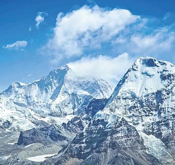
The Himalayan region is known as the “Third Pole” of the world, which rivals those of the polar regions, making it an essential environmental and ecological zone of global importance. This region is also called the “water tower of Asia,” because it serves as the primary source of freshwater for approx. 1.65 billion people, feeding into ten major river systems like the Ganges, Brahmaputra, Indus and Mekong.
- 1. Hydrology and Science Communication Research Lab, Department of Zoology and Environmental Science, Gurukula Kangri (Deemed to be University), Haridwar, India
- 2. School of Hydrology and Water Resources, Nanjing University of Information Science and Technology, Nanjing, China
- 3. School of Chemical Engineering and Physical Sciences, Lovely Professional University, Phagwara, India
- 4. Jindal Global Business School (JGBS), O P Jindal Global University, Sonipat, Haryana, India
These systems are closely integrated with the livelihoods and agricultural, energy, and biodiversity systems throughout South and Southeast Asia, and this region’s cryospheric, hydrological, and ecological systems. But this vital lifeline is facing unprecedented challenges due to climate change, a force that threatens its ecosystems, water resources and the human community that depends on them all. The Himalayas hold about 14% of the world’s ice reserves, after the Arctic and Antarctic. Its glaciers, snowpacks, and rivers serve as critical reservoirs regulating water flow to population centers downstream, including megacities. Himalayan glaciers store and release seasonal meltwater that feeds into river flow in its dry season, reduces the availability of water supply and helps mitigate against drought. This supports food security for millions through agricultural irrigation and hydropower generation. The region also has a hand in the monsoon, which acts as a climatic buffer by moderating seasonal rainfall patterns across Asia. The health of these natural systems is critical to regional stability, so the Himalayas are at the center of global concern over water security and climate resilience.
1 Introduction
The Himalayan region is known as the “Third Pole” of the world, which rivals those of the polar regions, making it an essential environmental and ecological zone of global importance. This region is also called the “water tower of Asia,” because it serves as the primary source of freshwater for approx. 1.65 billion people, feeding into ten major river systems like the Ganges, Brahmaputra, Indus and Mekong (Yao et al., 2012; Immerzeel et al., 2010). These systems are closely integrated with the livelihoods and agricultural, energy, and biodiversity systems throughout South and Southeast Asia, and this region’s cryospheric, hydrological, and ecological systems. But this vital lifeline is facing unprecedented challenges due to climate change, a force that threatens its ecosystems, water resources and the human community that depends on them all (Sati, 2020). The Himalayas hold about 14% of the world’s ice reserves, after the Arctic and Antarctic. Its glaciers, snowpacks, and rivers serve as critical reservoirs regulating water flow to population centers downstream, including megacities. Himalayan glaciers store and release seasonal meltwater that feeds into river flow in its dry season, reduces the availability of water supply and helps mitigate against drought. This supports food security for millions through agricultural irrigation and hydropower generation. The region also has a hand in the monsoon, which acts as a climatic buffer by moderating seasonal rainfall patterns across Asia. The health of these natural systems is critical to regional stability, so the Himalayas are at the center of global concern over water security and climate resilience (Shrestha et al., 2015).
An extension of the arc of great mountains in the world (like right now, a multi-continental outfit), the Himalayan range spans over 2,400 Km across India, Nepal, Bhutan, China, and Pakistan and supports a diverse array of ecosystems, from alpine tundra to subtropical forests. Mountain altitudinal gradients harbor remarkable biodiversity, featuring endemic plant and animal communities, and provide critical habitats for flagship terrestrial species of global importance (e.g., snow leopard, red panda). The interconnected ecosystems provide crucial ecological services in carbon crediting, soil stabilization, and biodiversity conservation (Kumar and Murugesh Prabhu, 2012). Not until you pause to think a little, the area’s socio-cultural diversity is truly remarkable. The Himalayas are home to over 50 million people of various ethnicities, customs, languages, and lifestyles. Traditional Indigenous systems offer resource management models, and solutions adapted to the harsh mountainous herding ecologies they have mastered. They provide ideas and information about how to live sustainably. Yet, given how climate alteration pressures exacerbate socio-economic demands, city activities must be balanced against the equilibrium and interlinkage of urban systems with the environment (Rana et al., 2021).
Despite growing recognition of the Himalayan region’s importance, several critical research gaps remain. First, there is a need for more localized and high-resolution climate models to predict regional impacts more accurately, as current models often fail to capture the complexity of microclimates and diverse landscapes within the region. Second, data on glacier retreat and hydrological changes in the context of future climate scenarios remain limited, hindering precise assessments of water availability in the region. Moreover, research on the socio-economic implications of these environmental changes—particularly in relation to livelihoods, agriculture, and infrastructure—lacks a comprehensive, integrated approach that accounts for both short-term and long-term impacts. Additionally, while indigenous knowledge systems offer valuable insights into climate adaptation, their integration with modern scientific techniques remains underexplored. Finally, there is a critical need for robust monitoring systems to track both environmental changes and socio-economic outcomes in real-time, enabling timely and effective policy interventions. Addressing these gaps is essential to building a resilient, adaptive framework for the region. The primary objective of this study is to assess the vulnerability of the Himalayan region’s ecosystems and socio-economic systems to climate change, with a particular focus on glacier dynamics, biodiversity, and water resource availability. This research aims to identify the key environmental and socio-economic risks posed by climate change, particularly those affecting water resources, agriculture, and infrastructure. Additionally, the study seeks to develop a comprehensive framework for region-specific, sustainable development policies that integrate climate resilience strategies, ecosystem-based adaptation, and the effective use of both indigenous knowledge and scientific innovations. This framework will help guide decision-making processes aimed at reducing the impacts of climate change and enhancing adaptive capacity in the Himalayas.
2 Climate change impacts on the Himalayan environment
The Himalayan region, crucial for its ecological and hydrological function, is highly sensitive to climate change, with significant impacts on the environment and human communities. Scientists and policymakers recognize the region as one of the world’s most vulnerable ecosystems, undergoing unprecedented changes in its cryosphere, hydrology, biodiversity and ecosystems that will ripple through water resources, agriculture and livelihoods. The details of climatic indicators have been discussed in below sub-sections.
2.1 Glacier retreat and cryosphere changes
Himalayan glaciers are retreating at an alarming rate due to global warming and impacting millions across Afghanistan, India, Nepal and Pakistan by threatening water supplies to major rivers, namely, the Ganges, Indus and Brahmaputra. The Gangotri Glacier has retreated over 1,500 m since 1935. With accelerated melting initially boosts runoff but leads to extreme water scarcity for millions far upstream once critical thresholds are crossed (Kumar and Murugesh Prabhu, 2012). Glacier retreat also expands glacial lakes, which heightens the risk of GLOFs. These floods can decimate infrastructure, communities, and ecosystems. For example, the 1985 Dig Tsho GLOF devastated Nepal’s villages, hydropower plants, and farmlands. Similar events, along with the growing risk from expanding high-altitude lakes such as Tsho Rolpa in Nepal, necessitate immediate plans for risk mitigation, including solid early warning systems and glacial lake monitoring.
2.2 Hydrological alterations
Changes in precipitation patterns due to climate change represent a major shift in the hydrology throughout the Himalayan region. Increasing temperatures have resulted in less snowfall and altered seasonal runoff dynamics, fundamentally changing river flows. The Melting of snow and glaciers has brought on the river peaks (flow) at an earlier time of year, with rivers such as the Indus facing changed seasonal streams. This change interrupts the flow of water needed for agriculture, drinking and utility-scale hydropower generation in downstream areas, especially during dry summer when water demand is at its peak. Climate change increases the variability of the South Asian monsoon, a key driver of Himalayan hydrology. Erratic monsoons — with heightened spates of rainfall and extended dry periods — exacerbate the potential for flooding and drought. For example, the 2013 floods in Uttarakhand were attributed to extreme rainfall due to changing monsoon dynamics, which caused severe infrastructural and human losses. The nexus of monsoon variability and glacial melt also has downstream impacts on sediment transport, groundwater recharge, and ecosystem health, exacerbating the water crisis in the region (Lepcha et al., 2021).
2.3 Biodiversity and ecosystem changes
The Himalayan region, renowned for its unique biodiversity and endemic species, faces significant threats from climate change, leading to habitat loss, species extinction, and shifts in ecosystem composition. Increased temperatures and changes in vegetation zones are causing habitat fragmentation, particularly in alpine ecosystems, which adversely affect species like the endangered snow leopard and red panda, reducing prey availability and pushing them toward extinction. Phenological changes, such as altered flowering times in Rhododendron arboreum and disrupted migration patterns in birds, are also impacting ecological interactions and food webs. For instance, the mismatch in the timing of plant flowering and herbivore grazing patterns destabilizes ecosystems. Furthermore, vital ecosystem services provided by the Himalayas, including water purification, soil stabilization, and carbon sequestration, are increasingly threatened by climate change and unsustainable land use. The degradation of forests and alpine meadows undermines their role in climate regulation and human livelihoods, while also negatively affecting the regional economy, particularly in agriculture, tourism, and disaster resilience. This underscores the need for integrated conservation efforts that prioritize both biodiversity preservation and human health (Yadav et al., 2021).
FIGURE 1

3 Impacts on human settlements and migration
The Himalayan region is sensitive to climate change and anthropogenic influences because of its fragile ecosystem and active geological processes. Such impacts degrade the environment and have broader consequences for human settlements, livelihoods, economic vulnerability, forced migration and human health and infrastructure.
3.1 Livelihoods and economic vulnerabilities
Himalayan communities rely heavily on climate-sensitive sectors such as agriculture, forestry and tourism for their livelihoods, but these are increasingly threatened by climate change. Shifting precipitation patterns, glacial retreat, and erratic monsoon seasons reduce agricultural productivity, and worsen food insecurity, and force migration, disrupting community structures (Vargas-Burgos et al., 2023). Forestry faces threats from altered vegetation cycles, biodiversity loss, and more frequent forest fires impacting timber and non-timber forest products (NTFPs) like medicinal herbs, which are crucial for income generation and subsistence for many communities. Tourism, a key economic driver, declines due to reduced snow cover and climate-induced disasters like GLOFs and landslides. These challenges exacerbate economic inequity, hitting the hardest of those most disadvantaged, including women and indigenous peoples, who directly depend on natural resources for food and livelihoods (Malik and Ford, 2024).
3.2 Displacement and migration
The rise in natural disasters in the Himalayan zone, such as landslides, floods and earthquakes, has led to the displacement of communities. Deforestation and unsustainable construction destabilize slopes and, with erratic rainfall, plunge them into devastating landslides that engulf entire communities. Likewise, river floods also displace thousands, making them homeless and vulnerable to secondary disasters such as epidemics and economic collapse. Increasingly, the movements have been driven by climate: entire communities have left for urban settlements looking for safety and livelihoods. This has flooded cosmopolitan centers with unregulated urbanization processes, shanty town expansion and scant access to basic needs such as potable drinking water, sanitation and medical services. Xenophobia, racism, and various forms of cultural alienation and isolation are also psychosocial risks carried by migrant groups due to socio-cultural struggles like loss of identity and social cohesion. Moreover, the migration of working-age populations can make rural settlements susceptible to labor shortages, hampering agricultural productivity and local economic development (Bhusal et al., 2021).
3.3 Infrastructure and health risks
The Himalayan region’s socio-economic development is highly impacted by climate-related hazards that damage critical infrastructure, such as roads, frequently destructed by landslides and floods, and hydropower plants increasing vulnerability through dam failures and downstream flooding. These challenges result in significant economic costs and hinder disaster recovery efforts. Additionally, climate change exacerbates health risks, including the spread of vector-borne diseases such as malaria and dengue to higher altitudes, increased respiratory illnesses due to declining air quality, and unaddressed mental health issues stemming from climate-induced displacement and livelihood disruptions. The uncertainty and violence around climate-induced displacement and livelihood disruptions make mental health issues—anxiety, depression, trauma—soaring. However, high burdens of disease already exist and the fragile healthcare infrastructure further struggles to address these emerging health challenges, placing vulnerable populations at greater risk (Alam et al., 2022).
4 Adaptation strategies and policy recommendations
Adaptation infrastructure in the Himalayan region must recognize that the interlinked crises of climate change, biodiversity loss and socio-economic vulnerability must come together (Figure 2).
FIGURE 2

Understanding people’s intentions to adapt to climate change is critical for designing effective interventions, as these intentions are shaped by risk perception, access to resources, and socio-cultural dynamics (Arunrat et al., 2017). Adaptation measures such as adopting climate-resilient agricultural practices, improving water management, and enhancing community-based disaster preparedness can strengthen resilience and reduce vulnerability. A core strategy is ecosystem-based adaptation (EbA), which harnesses the resilience of natural systems to insulate against climate impacts and support biodiversity. Transboundary conservation initiatives can help protect critical habitats and migratory corridors by strengthening protected area networks. Restoration with native species, land-use techniques, and soil conservation can reduce floods and erosion and be useful for carbon sequestration. Incorporating traditional ecological knowledge with scientific approaches ensures solutions that are culturally sensitive to the local populations, who remain an integral steward of the region.
Regarding policy recommendations, the involvement of the local community in decision-making must take precedence, reinforced by capacity-building initiatives and, potentially, sustainable livelihood avenues like agroforestry and ecotourism. Governments should establish strict constraints on uncontrolled urbanization, the overdevelopment of hydropower and resource overhunting. Even though the Himalayan ecosystem is transnational, collaboration between countries is necessary for sharing climate data and disaster management. In addition, robust climate financing mechanisms must be used to incentivize sustainable practices and deploy early warning systems to mitigate risk from glacial lake outbursts of floods and landslides. Such an inclination towards integrating these strategies to ensure the health and survival of the fragile Himalayan ecosystem would boost resilience, biodiversity, and livelihoods for millions of people (Kattel, 2022).
4.1 Community-based adaptation
Community-based adaptation emphasizes participatory approaches that integrate Nature-Based Solutions (NbS) to enhance resilience against climate change (Sultan et al., 2022). NbS, such as wetland restoration, afforestation, and sustainable agricultural practices, not only address local vulnerabilities but also ensure ecological sustainability while empowering communities to adapt effectively. Traditional irrigation systems like the kuhl in Himachal Pradesh and zabo in Nagaland are proven examples of sustainable water use that enhances resilience towards changing precipitation patterns. Likewise, the agroforestry techniques of Bhutanese farmers, who intersperse food crops with soil-stabilizing tree species, improve food security and mitigate the risk of landslides. This NbS approach enhances soil health, carbon sequestration, and biodiversity, while also providing multiple livelihood benefits. Many success stories illustrate the efficacy of community-based adaptation. In Ladakh, for instance, engineer Chewang Norphel created artificial glaciers that preserve winter snowmelt to supply summer drinking water and agricultural requirements. Grassroots women’s groups in Nepal have also adopted rotational grazing systems, and there is evidence that this reduces overgrazing and improves the grassland ecosystem. This is only a small sample of how empowering local communities and preserving traditional practices can lead to innovative, low-cost, sustainable solutions to climate resilience (Adhikari et al., 2018).
4.2 Technological innovations
New technologies are enhancing community-based adaptation in the Himalayas. Remote sensing (RS) and Geographic Information Systems (GIS) allow scientists to monitor near real-time monitoring of climatic variables for early warning systems help to facilitate risk assessments for landslides, glacial lake outburst floods (GLOFs), and other climate-induced disasters (ICIMOD’s satellite-based GLOF prediction systems. Climate-resilient agriculture practices are more and more vital for protecting livelihoods. Drought-resistant crops, precision irrigation techniques and crop diversification have all provided some success against erratic rainfall patterns. Renewable energy initiatives, such as micro-hydropower and solar energy farms, provide clean energy to remote settlements and contribute to decarbonizing the economy, as seen in Bhutan and Indian Himalayan villages (Kaku, 2019).
4.3 Policy frameworks and governance
Addressing the complex challenges in the Himalayan region requires comprehensive policy frameworks and effective governance mechanisms. The environmental impacts are transboundary in nature and the ecosystem is collective; therefore, it is essential to reinforce regional cooperation among Himalayan countries. Some initiatives, such as the Hindu Kush Himalayan Monitoring and Assessment Program (HIMAP), act as platforms for collaborative research and data-sharing between countries, creating collective approaches to adaptation. Integrating climate risks in national and local development plans Includes climate-proofing infrastructure projects, endorsing ecosystem-based adaptation, and integrating vulnerability assessments into land-use planning. Such initiatives are seen in actions, such as India’s own National Mission for Sustaining the Himalayan Ecosystem (NMSHE), which focuses on scientific research and policy measures based on the region’s requirements. International support is also crucial for making adaptation efforts possible. United Nations initiatives, notably the Green Climate Fund (GCF) and the Adaptation Fund support vulnerable communities with financial and technical assistance. Such resources can be redirected to strengthen capacity-building, promote technological innovations, and replicate successful community-based practices. But, these funds must be distributed equitably and used transparently to maximize the impact of the investment (Kotru et al., 2020).
5 Future research directions
The Himalayan region is home to complex geophysical and ecological systems that are becoming increasingly susceptible to cascading climate impacts on social and health systems, and thus, urgent and interdisciplinary research acts are required. One key direction is encouraging interdisciplinary approaches combining glaciology, hydrology, ecology, and socio-economic sciences to fully grasp interactions and feedback shaping environmental and societal vulnerabilities. These approaches are crucial for disentangling the complex impacts of glacier retreats, changes in hydrological regimes, and biodiversity shifts on human settlements and ecosystems. Participatory transition pathways (or collaborative frameworks that integrate climate science, local knowledge systems, and socio-economic analyses) reveal actionable insights that help communities construct adaptive capacity to their complex threat environments (Kumar et al., 2023).
Improving data availability is critical for advancing predictive modelling and evidence-based policymaking in the Himalayas. The substantial data gaps in areas such as glaciology, hydrology, and biodiversity hinder vulnerability and resilience assessments of the region. Investments in observational networks, including automated weather stations, satellite remote sensing, and field-based monitoring, are essential to create high spatial and temporal resolution datasets. Long term studies on glacier mass balance, hydrological flows, and biodiversity are needed, alongside cross-border data-sharing platforms to ensure inclusivity (Xenarios et al., 2019). Incorporating socio-economic indicators like migration, diversification of livelihoods, and poverty dynamics into climate resilience frameworks will guide context-specific, culturally appropriate adaptation strategies. The groundwork for future research must be laid in the form of interdisciplinary approaches, better data systems and ongoing socio-economic assessments, enabling an integrated response to the region’s emerging environmental challenges (Matta et al., 2022).
Climate change poses significant socio-economic challenges in the Himalayan region, particularly for communities that depend on agriculture, forestry, and tourism. Marginalized groups face more vulnerability due to limited adaptive capacity, poverty, and inadequate infrastructure. Addressing these environmental and socio-economic challenges requires coordinated local, national, and global efforts. Key strategies include strengthening early warning systems, supporting community-led adaptation initiatives, and funding region-specific climate research to enhance understanding of local climate dynamics (Jha et al., 2021). International cooperative frameworks are vital for transboundary resource management and disaster risk reduction. Sustainable development must balance environmental preservation with socio-economic upliftment through measures like sustainable infrastructure development, renewable energy adoption, and the enforcement of stringent environmental policies to mitigate the adverse impacts of climate change and ensure resilience without compromising natural resources or livelihoods (Matta G., 2020).
6 Conclusion
The Himalayan region, with its fragile ecological systems and reliance on seasonal climate patterns, is highly vulnerable to the cascading impacts of climate change, including melting glaciers, altered precipitation, and increased extreme weather events. These environmental stresses threaten freshwater availability, biodiversity, and increase the risk of natural disasters like landslides and floods. Adapting to climate change in the Himalayan region requires a combination of ecosystem-based approaches, such as afforestation and watershed management, alongside community-driven initiatives like sustainable agriculture and disaster preparedness programs. These measures can enhance resilience, safeguard critical ecosystem services, and ensure the sustainable livelihoods of vulnerable mountain communities.
To address these challenges, local communities must be empowered through education, capacity building, and access to green technologies, enabling them to contribute to sustainable, region-specific solutions. Moving forward, a collaborative, scientifically informed, and equity-centered approach is essential to developing policies that balance ecological preservation with the wellbeing of local populations. Such an approach will help safeguard the Himalayas, creating a climate-resilient model that can inform sustainable development globally. Researchers and policymakers must work together to ensure the long-term viability of both the region and its interconnected ecosystems.